Biosphere, hydrosphere and cryosphere models
PDF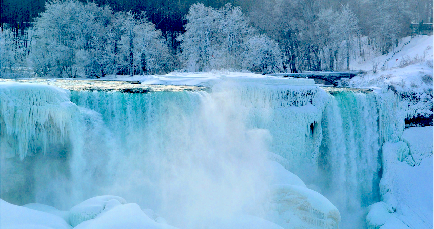
This article presents the importance of taking into account the Earth’s surfaces in Numerical Weather Forecasting, a step towards a more complete representation of the “Earth System”, with its living component (the biosphere), water exchanges between surfaces and the atmosphere (the hydrosphere), and ice surfaces (the cryosphere). This diverse and complex system is in continuous evolution, including man-made surface changes and the effects of climate change.
1. Introduction
The importance of an accurate description of land surfaces for numerical weather prediction is well established in the scientific community. Although the complexity of the Earth System requires conceptual and practical simplifications, the fundamental elements are configured to simulate reservoirs and flows (describing exchanges between reservoirs) at the interface between surface and atmosphere. The improvement of forecasts and their reliability at finer spatial and temporal scales and at longer time scales (monthly and seasonal) have motivated the progressive inclusion of surface processes in numerical weather prediction models, as well as for climate simulations and environmental applications.
Ocean surfaces, and more generally all open water surfaces, represent an energy storage that determines the temperature of the surface water and the exchanges of amount of movement between winds, waves, and currents [1]. This is important, especially in the tropical band because this mechanism is able to modulate the evolution of weather and climate on a large scale. Local-scale impacts are also visible at all latitudes, including breeze forecasting, atmospheric boundary layer development, fog formation, intense and localized precipitation and interaction with waves and sea ice.
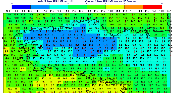
Continental surfaces are characterized by high variability in day and seasonal cycles, strong surface-atmosphere coupling, and the memory effect of water and energy stocks [2]. The role of land surfaces in prediction models is to provide a consistent description of water and energy cycles at time scales ranging from minutes to decades. The modelling of continental surfaces [3], [4] is therefore a necessary subject of study, to better represent the different physical processes in order to extend the reliability of weather forecasts. It is based first of all on an increasingly precise knowledge of physiographic characteristics such as terrestrial relief, the nature of the soil and vegetation, or ocean bathymetry [5] (illustration of relief in the ECMWF model, Figure 1).
At mid-latitudes, the coupling mechanism between the Earth’s surface and the atmosphere is represented by the evaporation-precipitation feedback [6], which influences meteorological parameters such as temperature, lower tropospheric humidity, and clouds. At high latitudes and in mountainous areas, the presence of snow affects the evolution of atmospheric temperatures because of its high albedo [7] and its thermal insulating power allowing decoupling between the surface and the atmosphere, causing strong temperature inversions observed near the surface in winter.
In addition to being a condition at the lower limit of the atmosphere for weather forecasting, continental surfaces also host the resources on which local populations depend (agriculture, transport, renewable energy production). In the case of extreme events, there is a direct danger to life and property and this increases the impact and importance of localized and reliable forecasting for risk prevention.
It is this dual role that has recently prompted meteorological centres to develop digital platforms dedicated to modelling and assimilating surface observation data. Their objective is not only to provide better surface characterization in weather and climate prediction models, but also to directly disseminate useful information on the present and future states of these resources, in the same way as what is done in weather forecasting.
In these platforms, the most realistic physical and biological processes are parameterized by diagrams describing the flows of matter, energy and amount of movement between the surface components (biosphere, hydrosphere and cryosphere) and the atmosphere.
2. The biosphere
The biosphere includes the bio-geo-physical processes of land surfaces including living species, and in particular the vegetation ecosystem. Numerous sensitivity studies have shown that the description of biophysical processes on continental surfaces can significantly affect the prediction of meteorological variables, such as precipitation, low-level wind or sheltered temperature.

The surface patterns adopted are representative of various spatial scales such as plant, field, watershed in the continental case, or an ocean basin with point observations. They are simplified representations of physical processes that describe the main feedback mechanisms, which can therefore be affected by systematic errors that are sometimes significant.
The main objective of surface schematics used in numerical weather prediction is to calculate the temperature and specific humidity at the lower limit of atmospheric models. These variables are necessary in the estimation of the flows, heat, water, quantity of movement, exchanged with the atmosphere.
Recently, the concept of time scale has been introduced into surface schematics. It distinguishes between surface layers that react directly to surface forcing, and deeper, less reactive layers that act as buffers for the surface and are more important for simulating anomalies in the water cycle (read : Do we risk having a water shortage?) and different soil temperatures, for example to represent the evolution of permafrost (read The permafrost).
The carbon cycle, in which all living species on the planet participate (read A Carbon Cycle Disturbed by Human Activities), is essentially reduced to the vegetation cycle in numerical weather prediction models. It plays an important role in the balance of energy and amount of movement on the surface. In climate modelling, the representation of the bio-geochemical processes of vegetation, soils and oceans is fundamental because it regulates the content of atmospheric carbon dioxide, for example through the photosynthesis process, which is a powerful mechanism for absorbing atmospheric CO2.
As part of the European Copernicus programme [8], an operational service for monitoring surface CO2 exchanges has been set up at the ECMWF. Its purpose is to provide objective information complementary to the forest inventories that currently allow the Intergovernmental Panel on Climate Change (IPCC) to monitor changes in CO2 flows (link to article on the IPCC).
The description of vegetation and other biologically related aspects, such as response to water stress conditions and bio-geochemical aspects (stock and biomass variations), are therefore important to facilitate monitoring activities and improve the quality of forecasts. Several studies have demonstrated the impact of a description of the seasonal vegetation cycle on evaporation. The leaf index [9], which changes with the season and water stress conditions, is often specified from satellite data (e.g. MODIS sensor). These data make it possible to construct a more realistic monthly climatology of the state of vegetation and to improve the simulation of water and CO2 exchanges with the atmosphere.
3. The hydrosphere
The main natural water flows are precipitation, evaporation, and runoff. The main water reservoirs in continental areas can be divided into four categories:
- soil (containing water in the root zone and often lower in the groundwater table, in liquid or ice form)
- vegetation (which has a high water content)
- snow (with a liquid water content varying from 10% to 50% by volume) and glaciers
- water reservoirs such as lakes and rivers.
Surface hydrologic diagrams describe the exchange of water between surfaces, the lower atmosphere and water infiltration into the soil. Manabe [10] introduced the first surface scheme into a general circulation model for climate study, in order to represent the water reservoir in the soil. This simple model considers a single water reservoir, allowing the evaporation of continental surfaces to be regulated according to their water content. These schemas then evolved into two-layer [11] or multi-layer models with finer vertical discretization. Infiltration is often represented according to Darcy’s law [12] generalized for unsaturated soils by Richards 13] with several developments from the watershed hydrology study. This allows the use of soil models, as in the case of the ECMWF [14], coupled with river routing models in flood forecasting, as in the Global Flood Awareness System project [15].
The oceans (read The marine environment) exchange heat

and momentum with the atmosphere. They influence the numerical weather forecast at all times. Heat exchange with the atmosphere depends on the surface temperature of the sea, which is itself influenced by weather conditions but also by ocean currents (e.g. Gulf Stream and Kuroshio in the northern hemisphere), and by climatic phenomena such as ENSO (El Niño Southern Oscillation), with strong consequences on atmospheric circulation at regional and continental scales.
The need to model the ocean is particularly evident at large temporal scales and in interaction with global warming [16], but also in prediction at a few days for extreme weather events such as tropical cyclones [17] (read Tropical Cyclones: Development and Organization). Often meteorological studies focus on surface exchanges in interaction with wind, waves and the ocean boundary layer. These developments are aimed at improving marine forecasting, particularly wave height, which is a prerequisite for all ocean resource transport and extraction activities.
Most meteorological centres are not yet considering the use of evolving ocean models coupled with the atmosphere in their operational chains. However, their introduction into meteorological forecasting represents an important development perspective that would respond to the challenges of coupled seasonal forecasting, for which the ocean is one of the main sources of predictability.
4. The cryosphere
Snow and ice (marine and continental) are important energy reservoirs that can delay the warming or cooling of the atmosphere and ground by releasing or absorbing latent heat. The snowpack is a very effective thermal insulator, as it can contain up to 90% air (for a density of about 100 kg/m3 in the case of freshly deposited snow). The processes that govern the evolution of the snow cover are complex and the schemes used in numerical models for weather forecasting only describe the effects of temperature and compaction related to mass, leading to an increase in density, as well as changes in albedo. Snow is also a very important reservoir of fresh water that modulates river flows, especially at high latitudes.
Snow cover and ice have a strong impact on the quality of weather and climate forecasts. Indeed, the absorption of solar radiation at the earth-atmosphere interface can be modified by a factor of up to four by the presence of snow following a variation in albedo (read The atmosphere and the gaseous envelope of the Earth). This albedo, which retroacts with surface temperature, helps to accelerate seasonal and climatic changes.
In high latitudes and mountainous regions, snow also acts as an important reservoir of energy and water. Therefore, an accurate representation of snow mass is crucial at all forecast times, with direct consequences for hydrology and temperature of the underlying surfaces.
Many snow models have been developed for various applications, such as snow process studies, runoff, and avalanche forecasting, and for atmospheric models. Brun et al [18] conducted a detailed analysis of existing models and their applications, which resulted in schemes for atmospheric models (global and regional). The purpose of these schemes is to provide conditions at the lower limit of the atmosphere for coupling over snow-covered areas. The water content of the snow and the energy flows between the snow cover and the ground are also important to achieve this goal. Particular attention should also be paid to the thermal insulation role of snow in controlling ground-ice atmosphere-coupling.
A better representation of the snow-atmosphere coupling [19], [20] has led to improvements in the prediction of surface flows at time scales from day to season. Similarly, sea ice modelling has been important in representing interannual evolution [21] and the significant reduction in ice extent and thickness due to global warming.
5. The Earth system
The representation of surface-atmosphere exchange processes for energy, water and carbon (among other components) is essential to model, and thus predict, the evolution over time of the Earth System state.
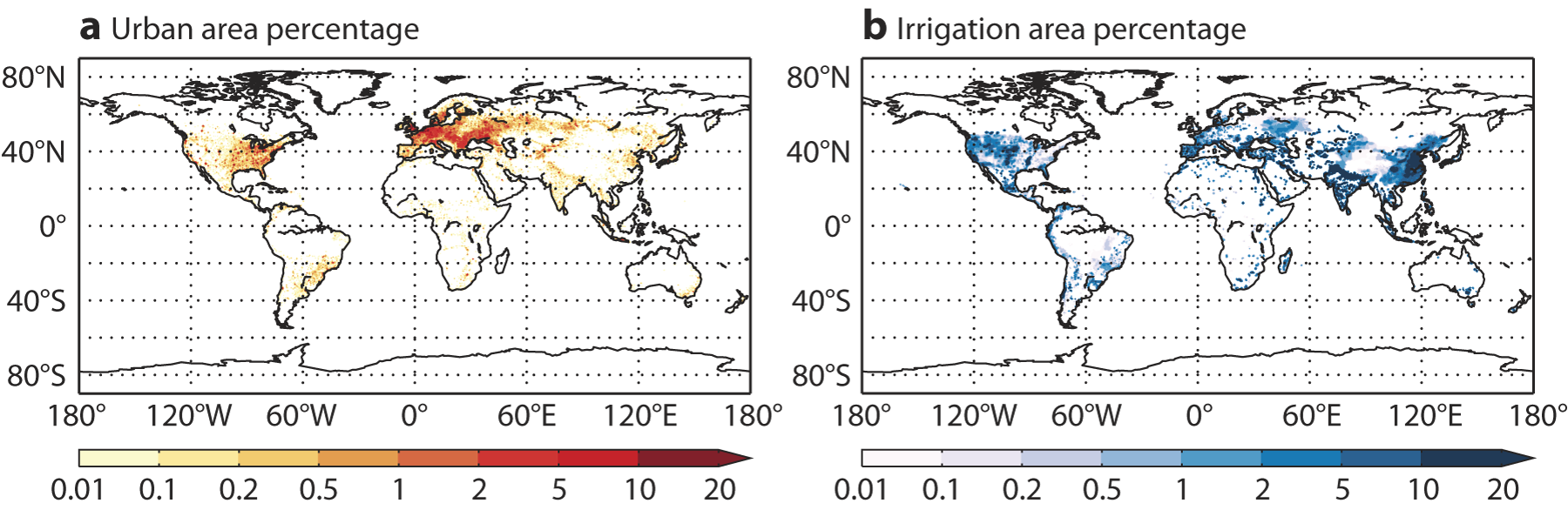
The study of terrestrial ecosystems is a priority in scientific research and its operational monitoring because sustainable development and the economy of societies depend heavily on it. Man himself is part of it by occupying a majority of the urban ecosystem, which is often poorly represented in meteorological-hydrological models, because urbanized areas occupy a fraction of the continental surface area of less than 1%.
Earth System modelling will soon have to consider the various anthropogenic changes affecting natural cycles, not only at the climate scale where the greenhouse effect is already being considered in a simplified way, but at all spatial and temporal scales. In this context, the modelling of global cycles of surface water, energy and biomass, at spatial resolutions high enough to represent the main physical processes, is a priority topic for Earth-System-Modelling research in numerical modelling.
The agro-ecosystem is particularly solicited, as it interacts most directly with society, through food production, which is strongly influenced by meteorological and climatic variability. Agricultural and forest land, most of which is managed by humans for resource production, must be modelled and monitored regularly to replicate irrigation and logging processes. These are able to induce significant atmospheric feedback in local and regional forecasting by changing the availability of water for evapotranspiration and by changing the surface roughness in interaction with winds.
Research progress on these components of the Earth System surface is based on the availability of observational data and in particular satellite remote sensing, which is the most appropriate means to achieve global and homogeneous coverage with sufficient frequency to describe processes. The remote sensing data available for real-time global monitoring of continental surfaces will increase thanks to the Copernicus Sentinels programme and the BIOMASS earth exploration mission of the European Space Agency ESA. This will make it possible to identify weaknesses in forecasting models and correct random and systematic errors in analyses as part of data assimilation (read Assimilation of meteorological data).
Despite the availability of these data sets, each of them will not be sufficient to fully characterize the condition of the surface. This requires an integrated approach to hydrometeorological and climatic surface assessment, as proposed to document the quality of climate re-analyses [22].
In the coming years, surface modelling platforms such as SURFEX [23] will enable the scientific community to make more federated progress in the representation of the natural and anthropogenic complexity of the Earth’s surface. These are very important efforts by weather services to meet the growing needs of environmental prediction.
References and notes
Cover image. Niagara Falls in winter, USA side
[1] Belcher SE, Hewitt HT, Beljaars A, Brun E, Fox-Kemper B, Lemieux JF, Smith G, Valcke S. 2015: Ocean-waves-sea-ice-ice-atmosphere interactions. In: Seamless Prediction of the Earth System: from Minutes to Months, WMO-No. 1156. World Meteorological Organization.
[2] Dirmeyer, P., C. Peters-Lidar, G. Balsamo, 2015: Land Atmosphere Interactions and the Water Cycle, In: Seamless Prediction of the Earth System: from Minutes to Months, WMO-No. 1156 2015. World Meteorological Organization.
[3] Balsamo, G., S. Boussetta, E. Dutra, A. Beljaars, P. Viterbo, and B. Van den Hurk, 2011: Evolution of land surface processes in the IFS, ECMWF Newsletter, 127, 17-22.
[4] Balsamo, G., A. Agusti-Panareda, C. Albergel, A. Beljaars, S. Boussetta, E. Dutra, T. Komori, S. Lang, J. Munoz-Sabater, F. Pappenberger, P. de Rosnay, I. Sandu, N. Wedi, A. Weisheimer, F. Wetterhall, E. Zsoter, 2014: Representing the Earth surfaces in the Integrated Forecasting System: Recent advances and future challenges, ECMWF Tech. Memo. 729 October 2014. http://doi.org/10.13140/2.1.4248.0324
[5] Bathymetry determines both the relief of the oceans and their local depth.
[6] Beljaars A., Viterbo P., Miller M. and Betts A. 1996. The anomalous rainfall over the United States during July 1993: Sensitivity to land surface parameterization and soil anomalies. My. Weather Rev., 124, 362-383.
[7] Albedo is the fraction of solar radiation reflected and not absorbed by the Earth’s surface.
[9] The leaf index represents the area of green leaves per unit of soil area.
The atmospheric circulation and the hydrology of the earth’s surface. My. Wea. Rev., 97, 739-774.
[11] Noilhan J. and Planton S., 1989: A simple parametrization of land surface processes for meteorological models. My. Wea. Rev. 117, 536-549.
[12] Darcy H., 1856: Les fontaines publiques de la ville de Dijon, V. Dalmont, Paris.
[13] Richards, L. A., 1931: “Capillary conduction of liquids through porous mediums”. Physics. 1 (5): 318-333.
[14] Balsamo, G., P. Viterbo, A. Beljaars, B. van den Hurk, M. Hirschi, A. K. Betts, and K. Scipal, 2009: A Revised Hydrology for the ECMWF Model: Verification from Field Site to Terrestrial Water Storage and Impact in the Integrated Forecast System. J. Hydrometeor, 10, 623-643.
[15] GloFAS, | http://globalfloods.jrc.ec.europa.eu/
[16] Balmaseda, M.A., K.E. Trenberth, and E. Källén, 2013: Distinctive climate signals in reanalysis of global ocean heat content, Geophys. Res. Lett., vol. 40, pp. 1754-1759. http://dx.doi.org/10.1002/grl.50382
[17] Glenn, S. M., Miles, T. N., Seroka, G. N., Xu, Y., Forney, R. K., Yu, F., et al. 2016: Stratified coastal ocean interactions with tropical cyclones, 7 SP. http://doi.org/10.1038/ncomms10887
[18] Brun, E., Z. Yang, R. Essery, and J. Cohen, 2008: Snow-cover parameterization and modeling. Snow and Climate, R. L. Armstrong and E. Brun, Eds., Cambridge University Press, 125-180.
[19] Boone, A., and P. Etchevers, 2001: An intercomparison of three snow schemes of varying complexity coupled to the same land-surface model: Local scale evaluation at an Alpine site. J. Hydrometeor, 2, 374-394.
[20] Dutra, E., P. Viterbo, P. M. A. Miranda, G. Balsamo, 2012: Complexity of snow schemes in a climate model and its impact on surface energy and hydrology. J. Hydrometeor, 13, 521-538. doi:10.1175/JHM-D-11-072.1.
[21] Vihma, T., 2014: Effects of Arctic Sea Ice Decline on Weather and Climate: A Review. Surv Geophys. 35: 1175. doi:10.1007/s10712-014-9284-0.
[22] Balsamo, G., Albergel, C., Beljaars, A., Boussetta, S., Brun, E., Cloke, H., Dee, D., Dutra, E., Muñoz-Sabater, J., Pappenberger, F., de Rosnay, P., Stockdale, T., and Vitart, F.: ERA-Interim/Land: a global land surface reanalysis data set, Hydrol. Earth Syst. Sci. 19, 389-407, doi:10.5194/hess-19-389-2015. 2015. http://www.hydrol-earth-syst-sci.net/19/389/2015/hess-19-389-2015.html
[23] Masson, V., Le Moigne, P., Martin, E., Faroux, S., Alias, A., Alkama, R., Belamari, S., Barbu, A., Boone, A., Bouyssel, F., Brousseau, P., Brun, E., Calvet, J.-C, Carrer, D., Decharme, B., Delire, C., Donier, S., Essaouini, K., Gibelin, A.-L., Giordani, H., Habets, F., Jidane, M., Kerdraon, G., Kourzeneva, E., Lafaysse, M., Lafont, S, Lebeaupin Brossier, C., Lemonsu, A., Mahfouf, J.-F., Marguinaud, P., Mokhtari, M., Morin, S., Pigeon, G., Salgado, R., Seity, Y., Taillefer, F., Tanguy, G., Tulet, P, Vincendon, B., Vionnet, V., and Voldoire, A.: The SURFEXv7.2 land and ocean surface platform for coupled or offline simulation of earth surface variables and fluxes, Geosci. Model Dev. 6, 929-960, doi:10.5194/gmd-6-929-2013, 2013.
The Encyclopedia of the Environment by the Association des Encyclopédies de l'Environnement et de l'Énergie (www.a3e.fr), contractually linked to the University of Grenoble Alpes and Grenoble INP, and sponsored by the French Academy of Sciences.
To cite this article: BALSAMO Gianpaolo (March 7, 2024), Biosphere, hydrosphere and cryosphere models, Encyclopedia of the Environment, Accessed April 23, 2024 [online ISSN 2555-0950] url : https://www.encyclopedie-environnement.org/en/air-en/biosphere-hydrosphere-and-cryosphere-models/.
The articles in the Encyclopedia of the Environment are made available under the terms of the Creative Commons BY-NC-SA license, which authorizes reproduction subject to: citing the source, not making commercial use of them, sharing identical initial conditions, reproducing at each reuse or distribution the mention of this Creative Commons BY-NC-SA license.