与河流共存:一个地貌学问题

drôme reserve ramieres

  河床是如何变化的?为何会发生变化?这是一个多学科交叉问题。对此,本文从地貌学角度进行研究,并给出几条基本建议。每条河流面对的威胁是什么?影响河流输沙量的原因是什么?威胁河流灌溉区生态环境的又是什么?这一系列问题倍受关注,尤其是对于罗纳河等配备了大型设施的大型河流。为促进河流的可持续化管理,专家们对河床的演变过程进行了模拟。

1. 什么是河床?
环境百科全书-地貌学-河床及其水位
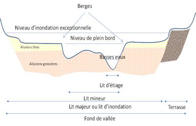
图1. 不同的河床及相应的水位。[©H.Piegay]
Berges 河岸;Niveau d’inondation exceptionnelle 异常洪水位;Niveau de plein bord 中枯水位;Alluvions fines 细冲积层;Alluvions grossières 粗冲积层;Basses eaux 枯水位;Lit d’étiage 枯水河床;Lit mineur 中枯水河床;Lit majeur ou lit d’inondation 洪水河床;Terrasse 河岸;Fond de vallée 谷底

  河道通常被定义为在一个几何形状中集中流动的运动水体,该几何形状即河床(图1)。河床的形状并不单一,水位亦是变化多端。大多数情况下,河流都处于中枯水河床中。中枯水河床的两侧是两个明显的斜坡地形,即河岸。中枯水河床中可容纳一个更小的河床——枯水河床,它所能携带的河流量是最小的。如果河岸足够陡峭,中枯水河床和枯水河床便会合并。否则,中枯水河床通常是湿河床,且河岸上存在着在枯水期留下的暴露底泥。在高水位乃至洪水时期,河水溢出至更宽阔的河床,即盛水河床或洪水河床,通常由历史最高水位或百年一遇、两百年一遇甚至更罕见的洪水对应的断面进行确定。
环境百科全书-地貌学-弧河和伊塞尔河的汇合处
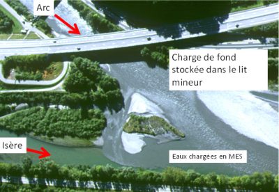
图2. 弧河和伊塞尔河的汇合处。弧河给伊塞尔河带来了大量的悬移质,在图中即水体颜色突出部分。伊塞尔河有大量由洪水带来的鹅卵石。[©EDF]
Arc 弧河;Charge de fond stockée dans le lit mineur 储存在中枯水河床中的推移质;Isère 伊赛尔河;Eaux chargées en MES 含悬浮固体的水体

  河床不仅能携带水,还能携带泥沙和漂浮物。漂浮物主要是有机质、植物碎片或树干。它们附着在河床上,有时交错成块,一旦形成冰堵塞,就可能阻碍水流甚至致灾粘土、淤泥和沙子等这些物质可以在水中移动,被称为悬移质。而一些更粗的物质(主要包括砂、砾石、鹅卵石乃至石块)只在河床底部运输,即推移质(图2)。中枯水河床及其河岸正是由推移质积淀而成。高水位期间,水流携带着较细的泥沙悬移,而后在宽阔的河床上沉淀,从而导致盛水河床的抬升。因此,冲积平原通常是砂质和粉砂质的。

  泥沙和漂浮物以不同的速度向下游移动。推移质(底泥)很少移动,甚至不动;唯有在山洪和洪水事件中,它可以移动得稍频繁且更远。推移质在洪水中能移动几百米,而悬移质在洪水中可移动几百公里。泥沙输送受水体的物理特性控制。较快的流速可以使泥沙颗粒保持悬浮、防止其沉积;河床底部的粗糙度决定了推移质移动过程中受到的牵引力和摩擦力。

  河床有不同的种类,坡度和流量的不同,决定了它们的水流速率和推移质输沙率也不同。地质环境也可改变河床的阻力,从而影响河床的特性。河床可由推移质或基岩构成。由推移质构成的河床被称为冲积河床,由基岩构成的则被称为基岩河床。

  河床有不同的样式,而且河床样式关系到航道的规划。在平原地区,由于侵蚀、沉积和推移质输送过程更活跃,河道更容易被冻结,河床更容易移位。河道所表现出的运动敏感性反映了一个事实——河道本身具有能量,且河床并非一成不变。

  河道可以是单通道,或多或少都有弯曲,连续的弯曲使河道呈蜿蜒之势,在平原上弯道更为明显(图3)。当河流蜿蜒时,河道中的流速是不对称的。在凹岸流速很快,所以凹岸常发生侵蚀。在凸岸流速较慢,有利于从上游凹岸剥离的泥沙在此沉积,进而形成河岸。山麓地区河流,如阿列河[1]或艾因河,因为河岸坡度更大,更容易形成蜿蜒的走势。这些河流到了平原地区以后,河道更易移动。

环境百科全书-地貌学-辫状河
图3. 左图:艾因河的低河谷部分,呈现出蜿蜒的走势,河道的移动造就了附近的植被。[©S.Dufour]。右图:阿拉斯加的谢里丹河。[©T.都柏林]

  河床的位移每年可以达到几米,河床逐渐移走留下一片新土地,植被在这片土地上生长。因此河岸植被很好地记录下了河床位移的过程。岸边植被是独特的景观单元,由凸岸边向外,逐渐向更老的景观过渡。河道也可以是多通道。当推移质很重时,难以将其搬移至岸边,便会形成辫状河。辫状河流是高山河流的典型风格。卵石为岸,组成数个中枯水河床,水流便在这些河床共同组成的多个通道中流动(图3)。

  河流是嵌套生态系统,包括水体、河岸环境和地下空间。河流也可作为附属的地理空间,归属于私人或市政当局,或用作公共活动场所。河流富含资源,如河沙、水源及水电能。河流用途广泛,可供钓鱼、航运,以及休闲娱乐。在水资源共享和发展选择等方面,河流的发展也存在冲突。河流也会存在污染、洪水或河岸侵蚀的风险。这些问题受到多种复杂因素的影响,如河流的地貌学特征、冲积平原的大小、环境的动态变化以及河道的不稳定性。

2. 从河床到河流地貌

  河流地貌学涉及三个方面,河床的几何形状,水、泥沙和漂浮物的组合形式,以及控制该组合形式的泥沙侵蚀、沉积和运输过程(见焦点1:什么是地貌)。

  初步的工作表明,中枯水河床主要受近期洪水的影响。利奥波德和沃尔曼作为先驱,开启了关于水体几何的研究领域。这在1964年出版的《地质学河流过程》一书中也有所提及[2]。形成中枯水河床或改变地貌水流被称为满溢流,即那些临时溢出河岸、在一两年内便会回到河床内的水流。因此,冲积河流的河床并没有特殊的形成机制,而是由近期发生的洪水控制的

环境百科全书-地貌学-河流地貌学
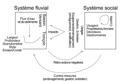
图4. 左边是河流系统两个等级(河段及其上游流域)的简化表示和基本交互参数,包括上游的控制参数和下游的调节参数。这一河流系统的演变与人类行为密切相关。[©H.Piegay]
Système fluvial 河流系统;Flux d’eau et de sédiments 水流和泥沙流;Bassin Versant 分水岭;Largeur Profondeur 宽度和深度;Granulométrie Style Erosion/Constr. 颗粒样式侵蚀/沉积;Tronçon 河段;Impacts 影响;Usages Gestion, Entretien Equipement/aménagement (endiguement, rectification) 使用管理维护设备/开发(遏制,整改);Système social 社会制度;Usagers Propriétaires fonciers Décideurs Gestionnaires 用户 土地所有者 决策者 管理者;Conflits 冲突;Rétro-actions négatives 负反馈;Contre-mesures (aménagements, gestion, entretien) 对策(改善、管理、维护)

  这些研究更新了我们对河床的看法。河流地貌学如今已是一门交叉学科(见焦点2:地貌学中的不同分支)(图4)。河流地貌学得到了S.舒姆的支持,他于1977年出版了《河流系统》一书[3],可作为参考。基于系统研究方法,学者借用了水文系统[4]这一概念。这一概念有助于构建河流地貌学和生态学之间的学科桥梁,并有助于将河流地貌学这一概念引荐到其它领域。因此,无论是2000年发布并同时开始记录数据的欧洲水资源框架指令(WFD)[5],还是1997年在法国发布的旨在指导和规划各种大型流域水资源政策的SDAGE(水资源开发和管理总体规划)[6],都提出了水文形态学这一术语,该术语即水文系统与河流地貌的结合体。

  长期以来,学者都认为河床是一个受控于水和泥沙的物理实体。上游汇流区的泥沙输送、水文气象循环,乃至人为扰动,决定了河床的发展条件。除此之外,生物成分也影响着河床的形成(见高山冲积景观和生物多样性)。

  河床的形成是流动力和阻力之间复杂平衡的结果。水流的能量主要取决于水位和河道的坡度河床的阻力则取决于构成河床的推移质的形态。推移质的比重越大、粘性越大、牵连结构越复杂,则越不容易被水流输送或侵蚀。河床及其边缘植被也增添了部分阻力,植被不论死活,其根系结构或多或少能有效地保护河岸,阻留推移质,限制侵蚀。

  植物的根植和生长也是影响河床阻力的重要因素。物种之间的竞争以及生物入侵机制,导致水土保持性强的物种更易于在岸边生存。这说明,河道的形状并不仅仅是一个物理问题生物和生态机制在其中也起着不可忽视的作用。在温暖的环境中,植物的生命力更顽强,生物和生态机制的重要性更明显,因而人类的行为对河道形状的间接作用也更明显。为此,我们必须认真考虑砍伐森林的后果。砍伐植被破坏河床斜坡的稳定性,显著增加河流的推移质输入,从而进一步改变河流的几何形状。在平原地区,单行、稳定和蜿蜒的河床更易于被移动性强的辫状河床取代。

环境百科全书-地貌学-于拜河与吉梅特河交汇处
图5. 于拜河(迪朗斯河的一条支流)与吉梅特河交汇处,左图摄于1895年[来源:RTM服务],右图摄于1996年。[©H.Piegay]

  新西兰北岛山脉和美国阿巴拉契亚山脉的森林砍伐活动,造成了壮观的河流变迁。科学文献中屡次提及这两个案例。而20世纪中期,欧洲退耕退牧活动对山脉的影响则可作为这两个案例的反例,情景同样壮观。退耕退牧使得流域和冲积平原的树林重建,植被的水土保持能力减少了下游的推移质输入促使河道下沉,辫状河卵石河岸逐渐被切断。这样一来,该处洪水和河床移动现象减少,同时表现出高度的植被化,长满了柳树和杨树。在某些情况下,退耕退牧还林会促使高山河流的典型风格(图5)(参考阅读材料:冲积高山景观和生物多样性)——辫状河的消失[7]。另外,19世纪中期引入的入侵物种造成美国西部的犹他州和亚利桑那州的河床急剧收缩[8],也是一个被频繁提及的案例。

3. 地貌学、风险管理、环境质量和可持续发展

环境百科全书-地貌学-河床演变及其对桥的影响
图6. 河床演变及其对桥的影响的两个例子。左图:河床的下沉会导致桥身结构不稳定[©F.Liebault,IRSTEA-ETNA];右图:河床上升阻碍了部分桥洞,促进局部洪水外溢[©H.Piegay]。

  河流风险管理[9]的公共服务部门越来越多地考虑地貌动态(见焦点3)。一些保护性的构筑物往往处于不断变化的河流环境中。河床的变化会逐渐改变建筑结构的稳定性,甚至可能演变为洪水和侵蚀[10]。随着时间的推移,河床不断位移,河岸的稳固性下降,进一步推动河床位移,加剧河岸侵蚀。

  洪水也在发生改变。由于城市化的推进,流域下垫面的渗水性能变差,洪水出现得更为频繁。城市化增加了地表径流,使得水流向下游的汇流速度加快,洪水也变得更为猛烈。如此一来,河床反复下沉上升,缩窄变宽,加剧破坏了建筑结构的稳定性。从另一个角度看,河床的变化也反映了河道正常容水量的变化(图6)。这些因素导致洪水或侵蚀对人类造成的危害风险增加,而非一成不变。
环境百科全书-地貌学-费雷特兰的杜河
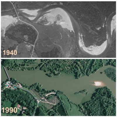
图7. 费雷特兰的杜河。1940年,它形成了一条蜿蜒美丽的河流,鹅卵石河岸表现出其活跃的泥沙输送。在20世纪90年代,经过几年的激烈采矿工程,它的河床成为一个巨大的湖泊,中断了沉积物的输送长达几十年。[资料来源:地质信息,IGN]

  砂石等建筑骨料的开采也影响了河流的几何形状(图7)。出于对河流效益及稳定发展的考虑,1994年起禁止在中枯水河床上进行建筑骨料的开采[11]

  这一禁令为承认河道的自由空间[12]铺平了道路。上述地区的开发旨在长期满足用户需求,确保流域发展,同时保护河流的自然基础设施。这一切都是为了可持续发展。河道的横向侵蚀以往一直被当作破坏河道的元凶;河道横向侵蚀的恢复需对河道的功能有所了解。横向侵蚀现在被认为是一个驱动生态和景观发展、保证环境质量和流域吸引力(图8)的良好契机。

  自由空间为河道功能优化创造了条件[13]。2016-2021年的罗纳-地中海SDAGE[14]定义了河道功能优化的空间,对包括开发、恢复、维护和保护等方面在内的人类干预活动进行了规划。这使得流域的利益相关者足以适应河流的动态性质,并尽可能地从河流自然基础设施中获益。这种对河流系统功能的适应性与如今被热议的人类社会在气候变化背景下的适应性产生了共鸣。
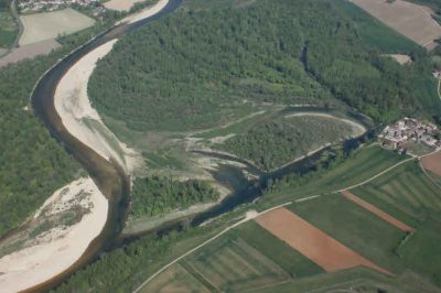
环境百科全书-地貌学-艾因河
图8. 艾因河:一条横向流动活跃、特种植物的生物多样性良好的河流,是保护河床移位工作的擎旗手。[资料来源:R.蒙塔格农UMR 5600 EVS]

  地表水地下水息息相关,地下水是供应饮用水和灌溉的真正水库。地表水和地下水之间通过河流的调蓄作用进行交换。地表水和地下水的交换正是一些具有巨大生态价值的水生栖息地的起源。在炎热季节,这种交换活动对某些物种非常重要。譬如地下水在夏季是河流的冷水源,是鳟鱼非常重要的避暑场所。许多生态栖息地实际上依托于某些特定的地貌功能,比如推移质在河床底部沉积,使得河床底部交替出现深区和浅区,紊乱的水流搅动流动的泥沙,避免底部出现阻塞。这些特点维持了地表水和地下水之间的水交换

  固体物质输送的中断或河床底部推移质的单一化可能会阻碍地表水与地下水的交换,并直接影响河流的生态营养。此外,水交换过程也驱动了天然的过滤作用,可部分净化农业排水中的硝酸盐,对水体的自净十分重要。如果同时存在河床下沉的情况,那么这一影响将会扩大至邻近的地下水水库。因此一些与河道接壤的城市不得不加深集水井,以满足用水需求。水资源的日益短缺也加剧了渔民、灌溉者、工厂等用户之间的矛盾。

4. 为罗纳河及其居民服务的地貌学

  越来越多的科学团队正在对大型河流的演变进行监测,以寻找那些复杂问题的答案。这些科研活动在美国科罗拉多州、密西西比州以及欧洲的莱茵河、多瑙河和罗纳河都有所开展,罗纳河在10年前建立了罗纳河泥沙监测站[15]

  罗纳河的诸多问题备受使用者、沿河地方当局、国家政府、水务局、主要运营商、CNR(罗纳河国家公司)和EDF等多方关注。罗纳河是否有可能支撑起在海洋的侵蚀下日渐撤退的卡马格三角洲,甚至朗格多克海滩呢?罗纳河沿岸修建的大坝是否充满了泥沙?推移质沉淀对罗纳河的管理或河流走廊是否有影响?经过一个世纪的发展,罗纳河能否做到改善河流的生态,使其满足通航与水电生产要求?罗纳河是否可能通过扩大其流量以防止洪水?罗纳河的开发是否会导致储存在主河床底泥中近一个世纪的污染物重新释放?这些都是来自罗纳河泥沙监测站(OSR)的研究人员、地貌学家、水力学家以及地球化学家们正在研究的问题。要想回答好这些问题,需要确定河流的演化轨迹,了解河流的功能,评估泥沙的输送能力,以及模拟河流的演变趋势

环境百科全书-地貌学-罗讷河上进行的修复工作示例
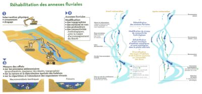
图9. 在罗纳河上进行的修复工作示例。[资料来源:RhonEco计划,免版税]

  开发罗纳河是一个长期项目,全长近500公里,涉及排水面积近10万平方公里。如今地貌学已发展为集体化、组织化和结构化的一门学科,且做到数据共享、结果公开且相互探讨。在河流研究上,地貌学与生态学、化学、生态毒理学、社会学和经济学相联系,采取一种多学科交叉的方法,帮助公民理解流域的演变。这项工作由罗纳河商业工作室(ZABR)[16]承担,具体来说,主要由负责日内瓦到地中海河流走廊的罗纳河谷人与环境观察所(OHMVR)[17]承担。

  保证生物栖息地的多样性是20世纪90年代开始的罗纳河恢复计划的一部分。实施过程中将一些次要支流与主河床重新连接在一起,并复活一些已经死亡的支流。开发者发现,对罗纳河恢复情况的科学监测[18](图9),可以评估这些支流的寿命,证明恢复计划实施的可持续性,并确认栖息地的多样性。


参考资料及说明

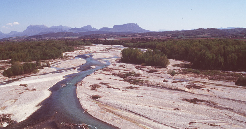
封面图片:拉米埃保护区的德罗姆河 [©H.Piegay]

[1] http://www.reserves-naturelles.org/val-d-allier

[2] Leopold L.B., Wolman M.G., Miller, J.P. (1964). Fluvial processes in geomorphology. Courier Corporation.

[3] Schumm S.A. (1977). The fluvial system. J. Wiley.

[4] Amoros C., Petts G.E. (1993). River hydrosystems. Masson, Paris.

[5] http://www.eaufrance.fr/comprendre/la-politique-publique-de-l-eau/la-directive-cadre-sur-l-eau

[6] http://www.gesteau.fr/presentation/sdage

[7] Liébault F., Piégay H. (2002). Causes of 20th century channel narrowing in mountain and piedmont rivers of southeastern France. Earth surface processes and landforms 27, 425-444.

[8] Gaskin J.F., Schaal B.A., (2002). Hybrid Tamarix widespread in US invasion and undetected in native Asian range. Proceedings of the National Academy of Sciences 99, 11256-11259.

[9] https://fr.wikipedia.org/wiki/Risque_naturel

[10] https://fr.wikipedia.org/wiki/Al%C3%A9a_(natural_risk)

[11] https://www.legifrance.gouv.fr/affichTexteArticle.do;jsessionid=7C92280118C88D99523A184D3D96E6B0.tpdjo03v_3?idArticle=LEGIARTI000022746086&cidTexte=LEGITEXT000021263114&dateTexte=20131208

[12] http://sierm.eaurmc.fr/sdage/documents/guide-tech-2.pdf

[13] http://www.gesteau.fr/sites/default/files/guide-technique-sdage-rmc.pdf

[14] https://www.eaurmc.fr/le-bassin-rhone-mediterranee/le-sdage-du-bassin-rhone-mediterranee.html

[15] http://www.graie.org/osr/

[16] http://www.graie.org/zabr/index.htm

[17] http://ohm-vr.org/index.php

[18] https://restaurationrhone.univ-lyon1.fr/


环境百科全书由环境和能源百科全书协会出版 (www.a3e.fr),该协会与格勒诺布尔阿尔卑斯大学和格勒诺布尔INP有合同关系,并由法国科学院赞助。

引用这篇文章: PIEGAY Hervé (2024年3月9日), 与河流共存:一个地貌学问题, 环境百科全书,咨询于 2024年10月4日 [在线ISSN 2555-0950]网址: https://www.encyclopedie-environnement.org/zh/eau-zh/learning-live-with-rivers-a-matter-of-geomorphology/.

环境百科全书中的文章是根据知识共享BY-NC-SA许可条款提供的,该许可授权复制的条件是:引用来源,不作商业使用,共享相同的初始条件,并且在每次重复使用或分发时复制知识共享BY-NC-SA许可声明。

Learning to live with rivers, a matter of geomorphology

drôme reserve ramieres

How and why do river beds change? At the interface of several disciplines, geomorphology studies this very particular environment and leads to essential recommendations. What are the threats to this or that river, to the quantities of solid materials it transports, to its ecological environment in the valley it irrigates? The case of large rivers, such as the Rhone, equipped with major facilities, attracts constant attention. It now leads specialists to simulate their evolution in order to promote sustainable management.

1. What is a river bed?

schema lit fluvial - river beds
Figure 1. The different river beds and associated water levels. [© H. Piegay]
A watercourse is generally defined as a body of water in motion concentrated in a geometry, a well-defined shape, in this case a river bed (Figure 1). The bed of a watercourse is a complex form. The water level is indeed very variable. The minor bed concentrates flows most of the time. It is limited by two well marked topographical slopes, the banks. It can house a smaller bed, the low water bed, which carries the lowest water. If the banks are steep, the low water bed and the minor bed merge. Otherwise, the minor bed has a wet bed and banks of exposed sediments at the low water level. In periods of high water, or even floods, the river overflows into a wider bed, the major bed or flood bed whose outer limits are arbitrarily defined as those of the highest known waters or a flood of a certain frequency (100 or 200 years, sometimes more).

confluence arc isere
Figure 2. Confluence of the Arc and the Isère rivers. The Arc brings to the Isère large quantities of suspended matter as highlighted by the colour of its waters. The Isère has large banks of pebbles that are set in motion during floods. [© EDF]
The bed not only carries water but also sediments and floats. Floaters are primarily organic matter, plant debris, sometimes tree trunks. When they settle in the bed or sometimes against structures, they can form ice jams that influence flows and can cause damage. Suspended solids, often consisting of clays, silts or even sands, can pass through the water while the coarser bottom load, mainly sands, gravel and cobbles, sometimes blocks, is carried on the bottom (Figure 2). It is in this bottom load that the river draws its minor bed and forms sediment banks. The major bed generally rises due to the finer sediments that arrive in suspension and settle by settling. Alluvial plains are thus often sandy and silty.

Sediments and floats move downstream at variable speeds. The bottom load may not move or very rarely. In mountain rivers, it can move much more frequently and farther, travelling several hundred metres during a flood. On the other hand, suspended or floating matter will travel several hundred km during the same event. This solid transport is governed by the physical properties of the water body, such as the flow velocities that keep particles in suspension, preventing their deposition, or the tractive forces or friction stresses that allow the movement and transport of the coarser sediments on the bottom.

There are a variety of river beds depending on the slope and flow rate that control the power of the current and the sediment load transported. The geological environment crossed also influences the characteristics of the river beds by influencing their resistance. The bed can be drawn in the sediments it carries (alluvial beds) or in the bedrock (rocky beds).

The bed has style! The river style corresponds to the plan of the channel. The channel may be frozen or more mobile in its plain, as the processes of erosion, deposition and sediment transport are more active. This sensitivity to movement is related to the fact that the watercourse has energy and its bed is not very resistant.

The watercourse can be single-channel and more or less sinuous, forming meanders, large curves in the plain (Figure 3). When the river has a winding or meandering bed, flow velocities are then asymmetric in the channel. Strong in concave banks, they favour their erosion. Weaker on the convex shoreline, they favour the formation of a bank resulting from the deposition of sediments torn from the concave bank immediately upstream. On meandering rivers in foothills areas such as the Allier [1] or the Ain, this meandering dynamic is active because the slope is still marked, and the channel thus moves in its plain.

riviere meandres - riviere tresses
Figure 3. Left: The Ain river in its low valley, a river with meanders whose mobility has generated the nearby vegetation. [© S. Dufour]. Right: the Sheridan river in Alaska. [© T. Dublin]
This movement, which can reach several metres per year, is well transcribed by the riparian vegetation that is gradually establishing itself in the newly created environments. It is characterized by distinct landscape units, which become older and older as we move away from the convexity bench. The watercourse can also be composed of multiple channels. When the bottom load is very heavy, it cannot easily evacuate it and forms braids. The braided style is typical of alpine rivers. The water then flows through several channels in a minor bed dominated by pebble banks (Figure 3).

The river is also a mosaic of ecosystems (water body, riparian environments, underground compartment). It is also a geographical space that belongs to someone, to a private person, to a municipality, and to the State for the older ones. The river has specific resources (aggregates, water, hydroelectricity). It is a space on which uses are exercised (fishing, navigation, leisure) and where there are sometimes conflicts (water sharing, development choices). It is also a risk area (pollution, flooding, bank erosion). The issues are more or less complex depending on the geomorphology of the river, the size of the alluvial plain, the dynamics of environmental renewal and the sensitivity of the channel to change.

2. From riverbed to river geomorphology

River geomorphology is concerned with geometry, the forms in which water, sediments and floats pass through, but also the processes of erosion, deposition and transport of sediments that govern these forms (See Focus 1, What is geomorphology).

Initial work has thus shown that the minor bed is primarily conditioned by current floods. This gave rise to a field of research around hydraulic geometry following work carried out by Leopold and Wolman. These authors are often considered to be the pioneers in the field. The book Fluvial Processes in Geomorphology [2], first published in 1964, is a reference. The flow that shapes the minor bed or morphogenic flow has since been considered as the full-body flow, i.e. the flow that just overflows over the banks and has a return period of 1 to 2 years. The bed of an alluvial river is thus shaped by current floods and not by exceptional events.

schema lit fluvial - representation rover system
Figure 4. Simplified representation of the river system (left) with its two levels of scale (the river section and its upstream catchment) and the elementary interacting parameters, both upstream (control parameters) and downstream (adjustment parameters). The evolution of this river system is closely linked to the system of actors. [© H. Piegay]
These approaches have renewed the vision we had of a riverbed. River geomorphology is thus nowadays part of a systemic perspective (see Focus 2, Different branches within geomorphology) (Figure 4). This school of thought was supported by S. Schumm, whose book “the fluvial system [3] published in 1977 is also a reference. The concept of hydrosystem [4], which stems from the systems approach, has helped to promote bridges with ecology and to introduce river geomorphology outside the academic field. The European Water Framework Directive (WFD) [5], which dates from 2000, thus refers to hydromorphology, as do the SDAGE [6] (Water Development and Management Master Plans) published in France since 1997 to guide and plan water policy in the various major river basins.

Long considered as a physical entity governed by water and sediments, conditioned by upstream controls (sediment sources and hydro-climatic cycle of the catchment area and their anthropogenic disturbances), the river bed also has a biological component that influences its form (read Alpine alluvial Landscape and biodiversity)

A bed is the result of a complex balance between flow and resistance forces. The energy of the water depends mainly on the water level and the slope of the channel. The resistance of the bed depends on the size of the sediments that make up the bed. These are more or less heavy, cohesive, nested, and therefore more or less difficult to move by flow, to erode. Resistance also depends on the living and dead vegetation in the bed and on its margins. Root systems are more or less effective in arming the banks, retaining sediments and thus limiting erosion.

The dynamics of plant colonization and growth is also an important factor that controls the resistance of a riverbed. Competition between species or biological invasion mechanisms may favour individuals that may be more or less resistant to flow. These factors are ecological and biological mechanisms that explain why the shape of a watercourse is not only a matter of physics. This is particularly the case in temperate environments where plant dynamics are active and where human actions have a significant influence on these dynamics. We are obviously thinking of deforestation, which can completely destabilize the slopes, significantly increase sedimentary inputs to rivers and profoundly transform their geometry. Single, stable and winding beds can thus give way in the plain to very mobile braided beds.

Figure 5. The Ubaye, a tributary of the Durance at the confluence with the Gimette in 1895 on the left [sources: RTM services] and in 1996 on the right. [© H. Piegay]
Deforestation in the New Zealand mountains of the North Island or the American Appalachians are examples of spectacular river adjustments, widely described in the scientific literature. The agricultural and pastoral decline that affected the European mountains in the mid-20th century is another equally spectacular example. The reforestation of watersheds and alluvial plains resulting from this diversion has helped to reduce sedimentary inputs downstream, promote channel sinking and disconnect cobble banks. As they were less often flooded and remobilized, they showed a strong vegetalization by willows and poplars. In some cases, this has contributed to the disappearance of braiding, an emblematic style of alpine rivers [7] (Figure 5) (read Alluvial Alpine Landscapes and Biodiversity). The effect of colonization of rivers in the western United States (Utah, Arizona) by the Tamaris [8], an invasive species introduced in the mid-19th century, is also a widely described case that has led to a dramatic retraction of river beds.

3. Geomorphology, risk management, environmental quality and sustainable development

exemples lit fluvial - evolution of river bed consequences on bridge
Figure 6. Two examples of the evolution of a river bed and its consequences on a bridge: on the left, the sinking of the bed can lead to destabilization of the structure, Pont des Chaines à Die. [©F. Liebault, IRSTEA-ETNA], on the right, the raising obstructs the section and can locally promote overflows. [© H. Piegay]
Public services in charge of river risk management [9] are increasingly taking into account geomorphological dynamics (see Focus 3). Protective structures are installed in changing environments even though they are fixed. These changes can thus destabilize them. These changes are also at the origin of an insidious evolution of the hazard [10] (flooding, erosion). A river can become more mobile over time and thus erode its banks more. This may be related to the fact that the banks are less resistant, as they have been de-vegetated, for example.

The flood regime may also have changed. Flooding is more frequent because the watershed has become less permeable due to urbanization. This urbanization favours surface runoff, a faster concentration of these runoffs downstream and more intense floods. If the bed deepens or, on the contrary, rises, retracts or widens, it can thus pose problems for the stability of the structures. It may also record a change in its flow capacity before overflowing and the frequency of flooding of the plain may itself change (Figure 6). Long considered as invariant, the hazard evolves and sometimes explains an increase in the risk of flooding or erosion to which populations are exposed.

Figure 7. The Doubs at Fretterans: in 1940, it formed a beautiful winding river with banks of pebbles underlining an active solid transport. In the 1990s, after several years of intense mining activity, its bed became a vast lake zone interrupting sediment transit for several decades. [Source: Géoportail, IGN]
The impact of aggregate extraction on the geometry of the river (Figure 7), the exercise of certain uses and the stability of certain developments led in 1994 to the prohibition of such extraction in minor beds [11].

This paved the way for the recognition of a space of freedom [12] for watercourses. This area aims to satisfy users in the long term and ensure territorial development while protecting the river’s natural infrastructure. It is an operational tool for sustainable development. Understanding the functioning of certain watercourses has thus made it possible to rehabilitate lateral erosion, long considered a scourge to be fought. This erosion is now perceived as an opportunity, an ecological and landscape driver, guaranteeing environmental quality and territorial attractiveness (Figure 8).

The space of freedom has paved the way for the space of good functioning [13]. This new envelope is defined in the SDAGE Rhône-Méditerranée [14] of 2016-2021 It is truly a tool for planning human interventions (development, restoration, maintenance, preservation). It allows local stakeholders to adapt to the dynamic nature of the river and to benefit as much as possible from all the advantages provided by this natural infrastructure. This adaptation to the functioning of river systems resonates with the adaptation of human societies that is being discussed today to cope with the consequences of climate change.

Figure 8. The Ain, an active lateral mobility, guarantees an exceptional plant biodiversity. A pioneering river in terms of conserving its mobility space. [Source: R. Montagnon for UMR 5600 EVS]
Surface water is often associated with groundwater, a real reservoir for drinking water supply or irrigation. There are also exchanges between this groundwater and the surface water drained by the river. These exchanges are at the origin of aquatic habitats of great ecological richness. They are sometimes extremely important for some species during hot periods. The groundwater supply is a cold water pocket in the river in summer. They are therefore very important thermal refuges for trout, for example. Many of these habitats are in fact the result of a particular geomorphological functioning with alternating deep (wet) and shallow (threshold) reaches drawn in the bottom load. The mobility of sediments limits the clogging of the bottom by stirring them at regular intervals. This mobility also maintains water exchanges between the two compartments.

The interruption of solid transport or the simplification of the bed bottom can alter this operation and have a direct impact on the ecological richness of the river. This operation is also very important for the natural filtration of water and thus makes it possible to ensure a certain self-purification with regard to nitrates of agricultural origin. If these changes are accompanied by bed sinking, the impact on the adjacent groundwater reservoir can also be significant. It is common that some municipalities, bordering sinking watercourses, have had to deepen their catchment wells in order to meet the demand for water. The increasing scarcity of water resources is also causing tensions between users (fishermen, irrigators, industrialists).

4. Geomorphology at the service of the Rhône and its residents

More and more scientific teams are organizing themselves to monitor the evolution of large rivers and answer sometimes complex questions. This is the case in Colorado, Mississippi but also in Europe, the Rhine, the Danube or the Rhône, on which a Rhône Sediment Observatory [15] was created 10 years ago.

There are many questions about the Rhône. They are of interest to users, local authorities along the river, the State, the Water Agency, and major operators, the CNR (Compagnie Nationale du Rhône) and EDF. Is it possible to supply the Camargue delta or even the Languedoc beaches, which are retreating under the influence of marine erosion, with fluvial sandy inputs? Do the dams built along its course fill with sediment? Does this have an impact on their management or on other parts of the river corridor? Is it possible to improve the ecological state of the river after a century of development to make it navigable and produce hydroelectricity? Is it possible to also improve its flow capacity by widening it to protect against flooding? Is there a risk of reintroducing into the river contaminants stored for a century in the sediments of its major bed? These are all questions on which researchers from the Observatoire des Sédiments du Rhône (OSR), geomorphologists, hydraulics, geochemists are currently working. The objective is to determine the evolutionary trajectory of the river, understand its functioning, evaluate its solid transport, simulate its evolution, and ultimately answer these questions.

travaux restauration rhone
Figure 9. Example of restoration work carried out on the Rhône. [Source: RhonEco Programme, royalty-free]
This is a long-term project, over a length of nearly 500 km that drains a catchment area of nearly 100,000 km2. Geomorphology today is done collectively, organized, structured, data is shared, results are public and discussed. Today, it is linked to ecology, chemistry, ecotoxicology, sociology and economics and contributes to an interdisciplinary approach that helps citizens to understand the evolution of their territory. This is the work of the Zone Atelier Bassin du Rhône (ZABR) [16] and more particularly of the Observatoire Homme-Milieu Vallée du Rhône (OHM VR) [17] on the river corridor from Geneva to the Mediterranean.

As part of the Rhône restoration plan initiated in the 1990s, remedial work has led to the reconnection of some secondary branches and the recreation of dead branches along the river in order to diversify habitats. Scientific monitoring of the restoration of the Rhône [18] (Figure 9) has thus made it possible to assess the lifespan of these arms, to demonstrate the sustainability of the actions undertaken and to confirm the diversity of the habitats created.


References and notes

Cover image. The Drôme in the Ramières reserve [© H.Piegay]

[1] http://www.reserves-naturelles.org/val-d-allier

[2] Leopold L.B., Wolman M.G., Miller, J.P. (1964). Fluvial processes in geomorphology. Courier Corporation.

[3] Schumm S.A. (1977). The fluvial system. J. Wiley.

[4] Amoros C., Petts G.E. (1993). River hydrosystems. Masson, Paris.

[5] http://www.eaufrance.fr/comprendre/la-politique-publique-de-l-eau/la-directive-cadre-sur-l-eau

[6] http://www.gesteau.fr/presentation/sdage

[7] Liébault F., Piégay H. (2002). Causes of 20th century channel narrowing in mountain and piedmont rivers of southeastern France. Earth surface processes and landforms 27, 425-444.

[8] Gaskin J.F., Schaal B.A., (2002). Hybrid Tamarix widespread in US invasion and undetected in native Asian range. Proceedings of the National Academy of Sciences 99, 11256-11259.

[9] https://fr.wikipedia.org/wiki/Risque_naturel

[10] https://fr.wikipedia.org/wiki/Al%C3%A9a_(natural_risk)

[11] https://www.legifrance.gouv.fr/affichTexteArticle.do;jsessionid=7C92280118C88D99523A184D3D96E6B0.tpdjo03v_3?idArticle=LEGIARTI000022746086&cidTexte=LEGITEXT000021263114&dateTexte=20131208

[12] http://sierm.eaurmc.fr/sdage/documents/guide-tech-2.pdf

[13] http://www.gesteau.fr/sites/default/files/guide-technique-sdage-rmc.pdf

[14] https://www.eaurmc.fr/le-bassin-rhone-mediterranee/le-sdage-du-bassin-rhone-mediterranee.html

[15] http://www.graie.org/osr/

[16] http://www.graie.org/zabr/index.htm

[17] http://ohm-vr.org/index.php

[18] https://restaurationrhone.univ-lyon1.fr/


环境百科全书由环境和能源百科全书协会出版 (www.a3e.fr),该协会与格勒诺布尔阿尔卑斯大学和格勒诺布尔INP有合同关系,并由法国科学院赞助。

引用这篇文章: PIEGAY Hervé (2019年2月7日), Learning to live with rivers, a matter of geomorphology, 环境百科全书,咨询于 2024年10月4日 [在线ISSN 2555-0950]网址: https://www.encyclopedie-environnement.org/en/water/learning-live-with-rivers-a-matter-of-geomorphology/.

环境百科全书中的文章是根据知识共享BY-NC-SA许可条款提供的,该许可授权复制的条件是:引用来源,不作商业使用,共享相同的初始条件,并且在每次重复使用或分发时复制知识共享BY-NC-SA许可声明。