Tornadoes: powerful devastating eddies
PDF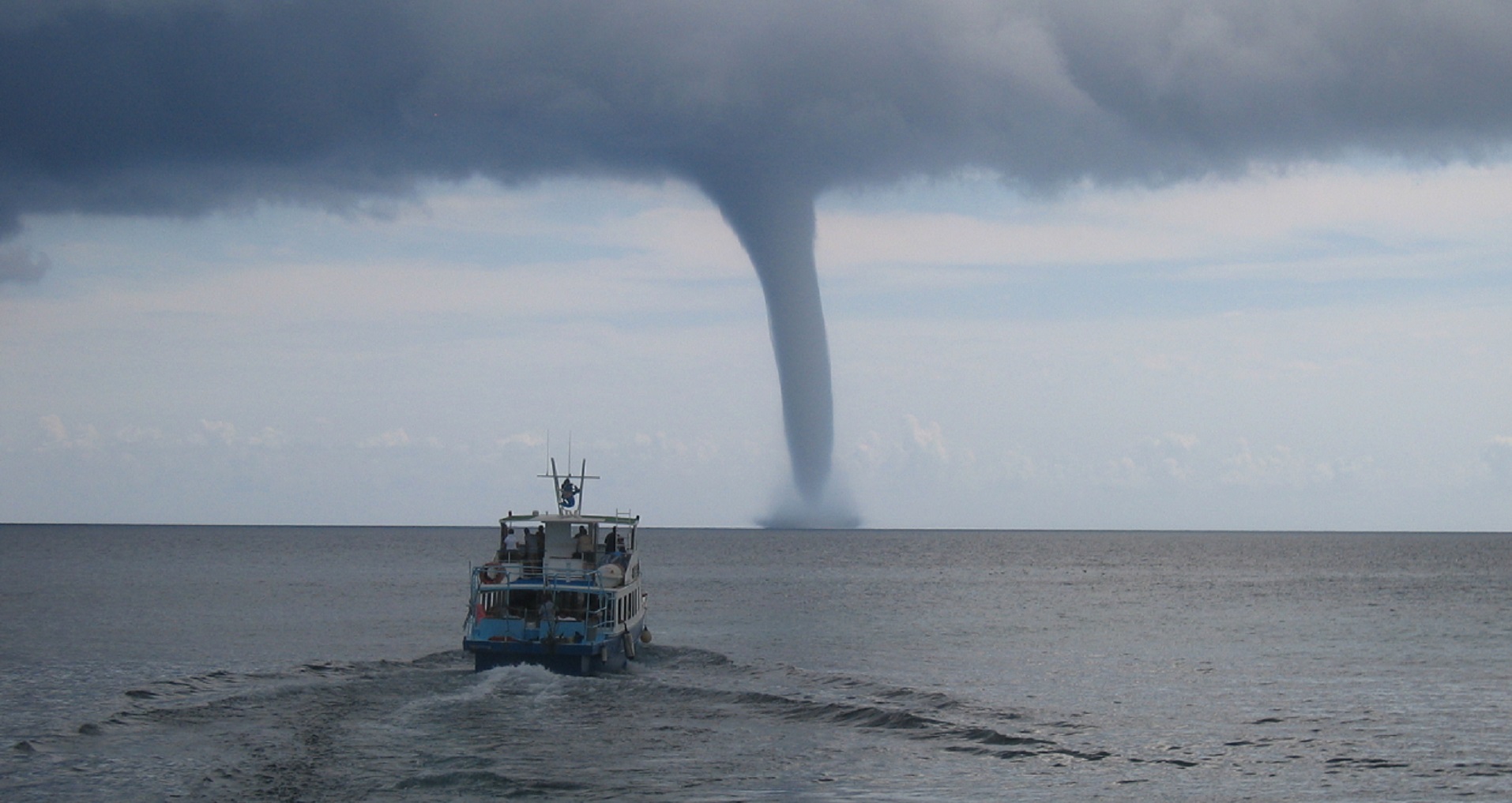
The strongest winds on Earth are due to tornadoes, causing devastation unmatched by any other phenomenon where they strike. The thunderstorms that give rise to them have very specific characteristics that are found in the central United States, but also in other mid-latitude regions. Most of the physical mechanisms that contribute to the intensification of these powerful atmospheric eddies are known. This makes it possible to predict the risks fairly accurately. However, the exact location and actual strength of tornadoes generated by a storm cannot be known precisely in advance. Also, although these extreme events are rare, it is useful to know how to protect yourself in the event of a possible encounter with such weather monsters.
1. A phenomenon as brief as it is intense
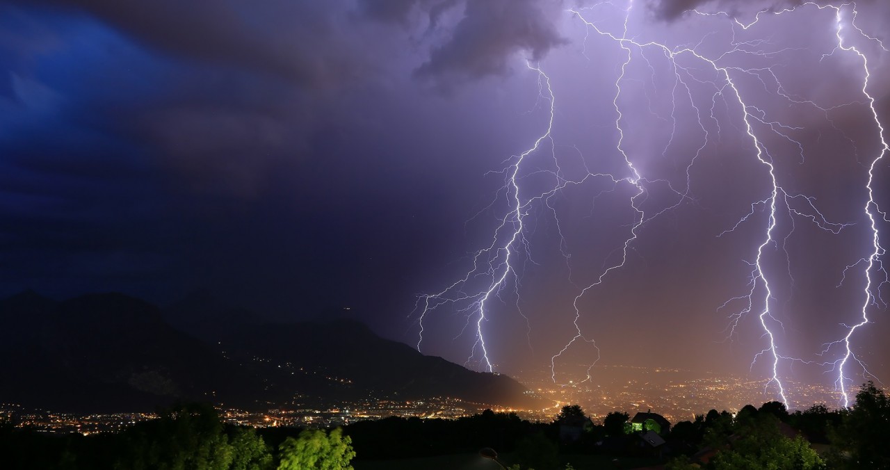
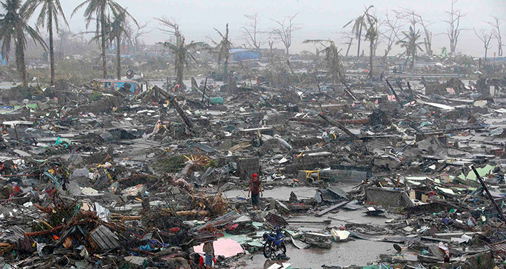
The strongest winds on Earth, with speeds up to and even exceeding 400 km/h, are due to tornadoes. These violent phenomena leave impressive traces of torsion, suction, tearing, lifting, signs of converging, ascending and swirling movements. The destruction that accompanies them is always considerable, sometimes with loss of human life. Tornado detection is difficult, which does not allow effective alerts to be issued, but it is possible to identify a potential risk when the atmosphere is very unstable with a very changing wind depending on altitude.
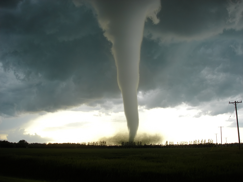
The diameter of the tuba varies from a few ten to a few hundred meters. Its visible vertical extension ranges from a few hundred metres to 2-3 kilometres, but its upper part hidden in the cloud mass extends much higher, up to altitudes of 8-10 kilometres. The lifecycle of a tornado is quite short, a few minutes at most, but the rapid movement of the violent storms that give rise to them explains why their impact on the ground can extend over several kilometres. In addition, storms often go through cycles of dissipation and redevelopment. They can thus successively give birth to several tornadoes, more or less powerful.
How do you recognize the birth of a tornado? One of the main warning signs of tornado development is the almost simultaneous appearance of an outgrowth below the base of the cloud and a strong swirl of dust on the ground. A snorkel then appears between these two points. It is made visible by the condensation of atmospheric humidity into liquid water droplets due to the pressure drop associated with the vortex. Initially fluctuating, the tuba stabilizes in a vertical position and widens as it intensifies. The most powerful tornadoes have a very turbulent appearance, accompanied by a dark mass of debris of all kinds raised by strong winds. Waterspouts are tornadoes that occur over liquid surfaces (seas or lakes), they follow about the same evolution as low-intensity tornadoes. The foot of a waterspout is surrounded by a foam ring about ten metres high, similar to the bush of dust and debris at the base of ground tornadoes.
2. More or less significant damage
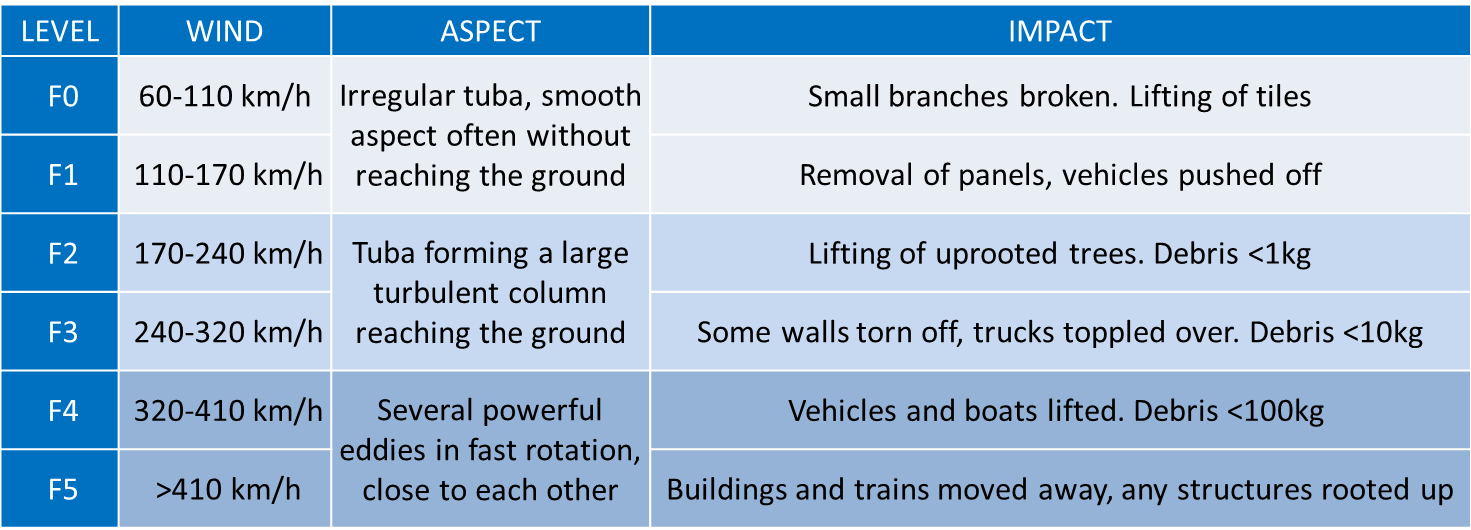
In 1981, American meteorologist Theodore T. Fujita proposed an intensity scale to classify tornadoes based on the damage and destruction they cause.
Table: Tornado intensity scale according to T.T. Fujita (1981) [1]
3. Global distribution of tornadoes
The great plains that stretch across the central North American continent, between the Gulf of Mexico, the Appalachians and the Rockies, are the region in the world where tornadoes are most frequent, associated with very high storm activity in the spring and early summer. They are responsible for the deaths of an average of 100 people per year and cause hundreds of millions of dollars in damage each year. In northern Texas, Oklahoma, Kansas and Nebraska, an area at risk is known as Tornado Alley, where 5 events per year can occur per 10,000 km2 area.
Globally, the areas affected by tornadoes are mainly in mid-latitudes. In the northern hemisphere, these phenomena are observed in Europe and Russia, east of India and Bangladesh, in the coastal part of China and in Japan. In the southern hemisphere, tornadoes occur in South and Eastern Australia, South Africa and between northern Argentina and southern Brazil. Tropical and equatorial areas are more spared, but waterspouts are sometimes observed.
In France, the climatological study by Jean Dessens and John T. Snow [2], published in 1989, reveals three more exposed areas: the northwest in a strip of land from Poitou to Picardy and Champagne, the east between Lyonnais and Jura, and the Mediterranean coast. Most tornadoes occur between May and September, a period of frequent thunderstorm activity. However, some of them are observed in winter, in connection with the passage of particularly active cold fronts. On average, there are one to two weak tornadoes (of F0 or F1 intensity) per year and per department. The risk of strong tornadoes (F3, F4 or F5) seems limited to the most active regions, with an average frequency of one event every 5 years or so.
The event that struck the Val de Sambre, in the northern department, on the evening of 3 August 2008 was thus analysed as a tornado of category F3 or F4. Following a trajectory of about twenty kilometres, the tornado hit several municipalities, with maximum intensity in Boussières-sur-Sambre and Haumont. Three people died, eighteen were injured, and many homes were destroyed. The amount of the devastation was estimated at around € 2 million. To date, it is the most violent tornado to hit France in more than 30 years.
4. In the heart of the whirlpools
What is the mechanism of the vortices? Everything is based on vorticity, a vectorial quantity that measures locally the rotation of a fluid flow, in this case air (see Focus); it is measured in revolutions per second. A vortex is a region of fluid with a strong vorticity. The vortex axis is the direction towards the vortex vector points. Transverse variations in wind speed or direction can also lead to ambient vorticity.
Vorticity can vary in direction or intensity for several reasons. First this quantity can be transported horizontally or vertically by the movements of the air as a characteristic of the fluid, this is called advection. Speed variations play a dual role in the evolution of the vortex: much as skaters accelerate (or slow down) their rotation by tightening (or widening) their arms, vorticity intensifies (or decreases) when there is convergence (or divergence) of the wind, it is the convergence effect. On the other hand, horizontal or vertical shearings, i.e. transverse variations of wind components, cause changes in the direction of vorticity without modifying its intensity, we call it inclination. Thus a vortex of horizontal axis transported by a horizontal flow sees its axis gradually become vertical when the flow tilts towards the vertical. The vortex can also intensify in the presence of simultaneous variations, and in different directions, of the air velocity and temperature, through the baroclinic effect. It is also necessary to take into account the dissipation effect due to turbulent processes and surface friction that tend to reduce spatial variations in vorticity.
Studying the formation and evolution of tornadoes requires describing the sources of vorticity in the atmosphere and then their concentration in eddies with horizontal dimensions less than one kilometre. Several phenomena follow one another. The first source of vorticity is the rotation of the Earth and is a source of vertical axis vorticity whose intensity varies with latitude. It is maximum at the poles with a rotation per 24 hours, and zero at the equator. But the tornadoes cannot be explained by the concentration of this ambient vorticity because the time required to reach the typical values of tornadoes – 1 rotation per few seconds, i.e. amplification by a factor greater than 10,000 – by one of the processes mentioned above would require much longer times than the average lifetime of storms (a few hours at most).
The second source of vorticity, which is a more important reservoir is the vertical shear of the horizontal wind, in intensity or direction. Thus, a wind speed variation of 20 m/s over a vertical distance of 10,000 m gives a vorticity of 2 10-3 s-1. This value is equivalent to a period of about one hour to complete a complete lap. This is already 25 times faster than the Earth’s rotation at the pole. The powerful vortex motion associated with tornadoes results from the vertical inclination of this ambient horizontal vorticity, then its amplification by converging movements, and its transport to altitude or to the ground by ascending and descending currents.
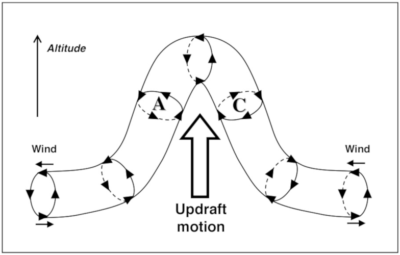
In terms of vorticity, the development of an updraft – such as that accompanying the development of a thunderstorm – in an environment subject to vertical shear of the horizontal wind produces a deformation of the axis of the ambient vortex by the tilting effect (Figure 2). The updraft is then associated with a doublet of cyclonic and anticyclonic eddies. But these two whirlwinds of opposite directions do not have the same destiny. Indeed, wind shear is generally not constant, often changing direction with altitude. Thus, in the northern hemisphere the wind can come from the southeast in the lower layers, from the southwest in the middle troposphere and from the northwest with a higher intensity at high altitude. In such a situation, the pressure disturbances associated with cyclonic movements generate a vertical force that amplifies the updraft, while they attenuate it on the high-pressure side, which disappears quite quickly. Soon the vorticity of the updraft angles parallel to its speed, forming a stable Beltrami flow stable and resistant to turbulent dissipation.

After an initial phase of concentration and vertical transport of the cyclonic vortex associated with the updraft, the development of the downdraft opens a new phase. On the one hand, the maximum vorticity ceases to ascend and descends to lower altitudes. On the other hand, the strong contrast of horizontal wind and temperature between warm and cold updrafts strengthens the vortex at their interface (Figure 3).
At this moment the wall cloud appears, a rotational growth that develops under the base of the cloud and whose rotation begins to be visible to the naked eye. This structure, a few hundred meters wide, is the mark of a powerful whirlwind ready to give birth to a tornado. Its rotation period is a few minutes, with a vorticity of 10-2 to 10-1 s-1 (10 to 100 times more intense than that associated with wind shear, and a swirling wind speed of 50 to 100 km/h). The tornado forms between the cloud wall and the ground by concentrating the vortex between updrafts and downdrafts in an area of heavy precipitation, violent gusts, and generally sustained electrical activity.
The gradual intensification of the downdraft during the evolution of the storm increases the amount of cold air in the lower layers, which further reduces the supply of warm, moist air to the updraft. The latter gradually fades away, and the intensity of the vortex decreases within the storm. Deprived of its amplifier mechanism and deformed by the progression of cold air, the tornado gradually dissipates after being stretched and undulated. But thunderstorm activity can redevelop a little later and generate again the process of inclination, concentration and transport of ambient vorticity related to wind shear. Thus, it is not uncommon to observe successive occurrences of tornadoes during the propagation of the same thunderstorm, multiplying the damage caused.
5. Anatomy of tornadoes
The appearance and destructive power of a tornado depends on the intensity of the vortex generated by the storm. However, due to its small size (a few dozen to a few hundred metres at most), and the strong winds blowing there, it is not easy to make accurate observations. Current knowledge therefore comes mainly from remote observations by optical means (photogrammetry) or by means of mobile meteorological radars deployed in the vicinity of these dangerous phenomena by intrepid experimenters. In recent years, very high resolution numerical simulations have also provided useful information.
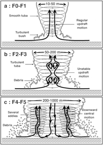
Low intensity tornadoes (F0 to F1 scale) have a smooth looking tuba with an upward flow in their center (Figure 4a). The flow is rather regular and the air is rotated at a constant angular velocity, like that of a solid body. This situation is called the Rankine vortex.
For medium tornadoes (F2 to F3 scale), the tuba has a more turbulent appearance (Figure 4b). Areas of disbonding where vertical velocity becomes downward along the central axis are formed at high elevations. As intensity increases, these regions become more numerous and progress towards the ground surface, associated with tuba expansion and ripples.
In high-intensity tornadoes (F4 or F5 scale), the flow is downward to the centre of the circulation (Figure 4c). The cylindrical symmetry of the flow gradually disappears and secondary eddies frequently form a few tens or hundreds of metres from the axis, rotating around the central axis. Their number increases with the intensity of the tornado, up to six can be counted at the same time for the most powerful tornadoes. Nevertheless, it is difficult to visually distinguish these multiple eddies within the vast set of debris of all kinds ripped off the surface by strong winds. In such situations, winds result from the combination of all these rotational movements, which explains the importance of the devastation caused by the most powerful tornadoes.
6. How to protect yourself?
Even if the probability of encountering a tornado is quite low – unless you live in the Tornado Alley in the central United States of America – it is useful to know what to do about these dangerous phenomena. While low-intensity tornadoes (F0 and F1) are in fact only slightly violent swirling gales, they are nevertheless likely to cause material or physical accidents through falling branches or tiles, or overturning light constructions. When, during a storm, a conical growth develops from the base of a cloud to the ground, a sign of the formation of a tornado, it is therefore advisable to seek the shelter of a solid construction.
Tornadoes of medium (F2 and F3) and especially strong (F4 and F5) intensity have much more serious material consequences and can endanger human lives. They are mainly distinguished by the turbulent nature of the tuba and the width of the debris vortex. They are also accompanied by loud noise, similar to that of a train passing or an aircraft taking off. First of all, tornado storms spread very quickly, at speeds of up to 100 km/h. Also, when a tornado occurs nearby, it is always better to protect yourself on the spot, rather than trying to escape, even in a vehicle, because the tornado can eventually catch up with it.
The best protection is that provided by the foundations of a building or cellars. If this is not possible, seek shelter in the most central room, protecting yourself with blankets or mattresses. Above all, avoid standing near doors and windows, which are easily torn off and sprayed by strong winds, and which expose you to debris thrown into the air at very high speeds. When there is no hard shelter, some protection can be found by lying down in a trough and protecting your head with your arms to provide as little grip as possible in strong winds. In any case, it is especially important to avoid staying in a structure that does not offer sufficient protection, such as cars, trucks, caravans, mobile homes, easily carried away and destroyed by tornadoes. Unfortunately, this is the fatal mistake made by most victims who mistakenly believe they are seeking refuge there.
References and notes
[1] T.T. Fujita, 1981: Tornadoes and Downbursts in the Context of Generalized Planetary Scales. J. Atmos. Sci. , 38, 1511-1534.
[2] J. Dessens and J.T. Snow, 1989: Tornadoes in France. Weather Forecasting, 4, 110-132
The Encyclopedia of the Environment by the Association des Encyclopédies de l'Environnement et de l'Énergie (www.a3e.fr), contractually linked to the University of Grenoble Alpes and Grenoble INP, and sponsored by the French Academy of Sciences.
To cite this article: ROUX Frank (January 5, 2025), Tornadoes: powerful devastating eddies, Encyclopedia of the Environment, Accessed August 2, 2026 [online ISSN 2555-0950] url : https://www.encyclopedie-environnement.org/en/air-en/tornadoes-powerful-devastating-eddies-2/.
The articles in the Encyclopedia of the Environment are made available under the terms of the Creative Commons BY-NC-SA license, which authorizes reproduction subject to: citing the source, not making commercial use of them, sharing identical initial conditions, reproducing at each reuse or distribution the mention of this Creative Commons BY-NC-SA license.