龙卷风:强大的毁灭性涡旋

Encyclopédie environnement - tornades - couverture

  龙卷风系统可以产生地球上最强的风,造成的破坏是任何其他现象所无法比拟的。在美国中部以及其他中纬度地区,引起龙卷风的雷暴极具特点。作为一种强大的大气涡旋,龙卷风背后存在一系列物理强化机制,其中大多数已为人所知,较准确地预测龙卷风险情因而成为可能。然而,我们目前仍无法精准预判风暴中形成的龙卷风的确切位置和实际强度。此外,虽然龙卷风很罕见,但了解面对这种凶险的极端天气现象时的自保措施还是非常有用的。

1. 一种短暂但剧烈的现象

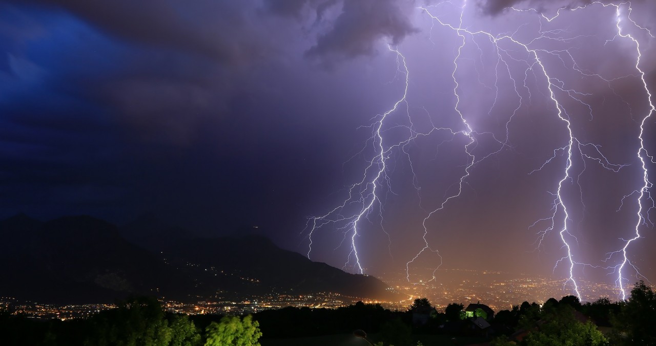
  龙卷风系统可以产生地球上最强的风,风速高达甚至超过400 km/h。这种天气现象堪称残暴,所过之处皆是扭曲、抽吸、撕裂、掀举的残迹,令人触目惊心。龙卷风以辐合且螺旋上升的气流运动为标志性特征,往往伴随着严重破坏,有时甚至会造成人员伤亡。探测龙卷风十分困难,所以很难及时发出有效的警报,但是当大气垂直风切变很大,大气结构非常不稳定时,我们可以发现潜在的风险。

环境百科全书-龙卷风-高强度龙卷风。
图1. 2007年6月22日,加拿大曼尼托巴省伊利村附近的一场高强度龙卷风。[来源:贾斯汀·霍布森(Justin Hobson)摄影作品]

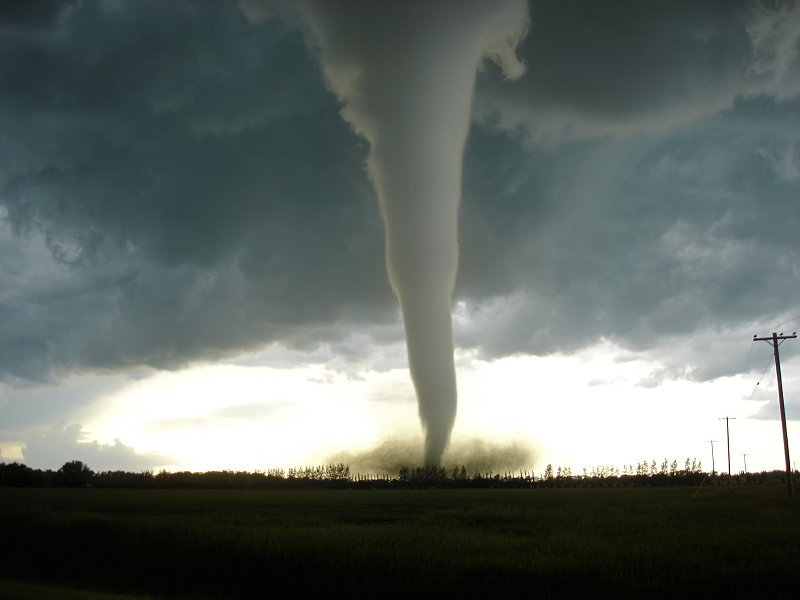
  龙卷风是一种大气旋风,具备强风、近乎垂直的旋转轴和气旋性旋转(北半球逆时针方向,南半球顺时针方向)等特点。其可见部分呈垂直圆柱或圆锥状延伸,形成一种喇叭状系统。龙卷常见于发达的对流云、积雨云或更少见的浓积云(图1)底部,一般发生在风暴的中心区,且经常伴随着暴雨、冰雹和强雷电。

  龙卷风喇叭状部分的直径从几十米到数百米不等,垂直可见部分的范围从几百米到2至3公里不等,但其隐藏在云层中的部分可上延至8至10公里的高空。虽然龙卷风的生命周期相当短,最多只有几分钟,但引起龙卷风的强烈风暴可迅速移动,龙卷对地面的影响因而可达数公里之远。此外,风暴往往会经历多轮消散和再生,在此过程中可以先后创造多个强度不一的龙卷风。

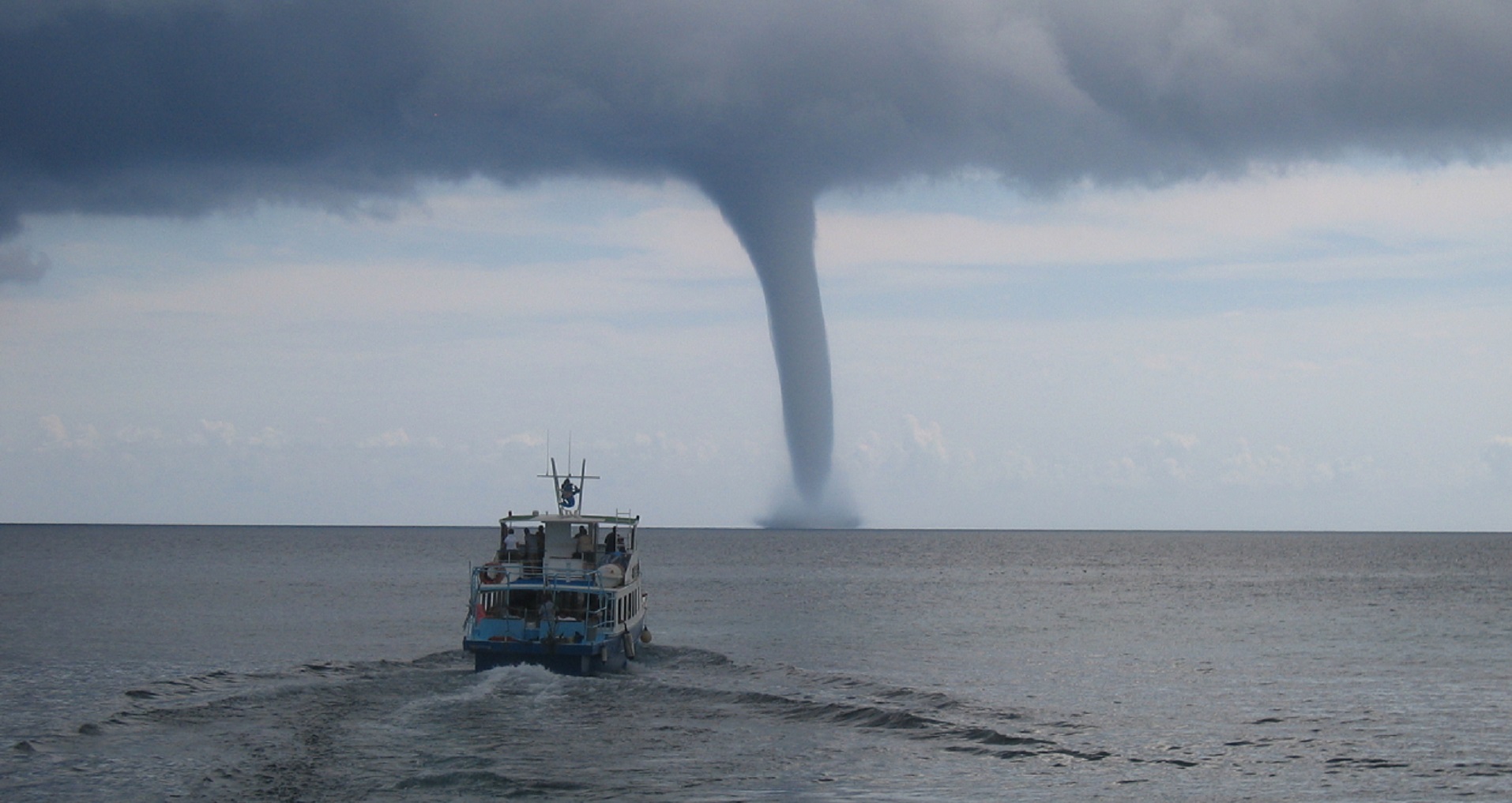
  怎样察觉龙卷的产生?龙卷发展初期,会发出一个警告信号——云底和地面几乎同时出现异动,云底的一部分向下旋转延伸,地面上的尘土相应形成强烈的漩涡。随后,二者逐渐连通,涡旋使气压降低,大气中的水汽凝结成液态水滴,龙卷因此变得清晰可见。初期波动后,龙卷的喇叭状系统将以垂直姿态稳定存在,并随着涡旋的加强而扩大。强龙卷的外观可见强烈的湍流,大量各种各样的碎片被强风卷起,形成一个黑色的云团。海龙卷(waterspout)则是发生在液体表面(海洋或湖泊)上的龙卷,其演变过程与低强度龙卷大致相同。海龙卷的底部被一个约10米高的泡沫环包围,类似于地面龙卷底部的灰尘和碎片团。
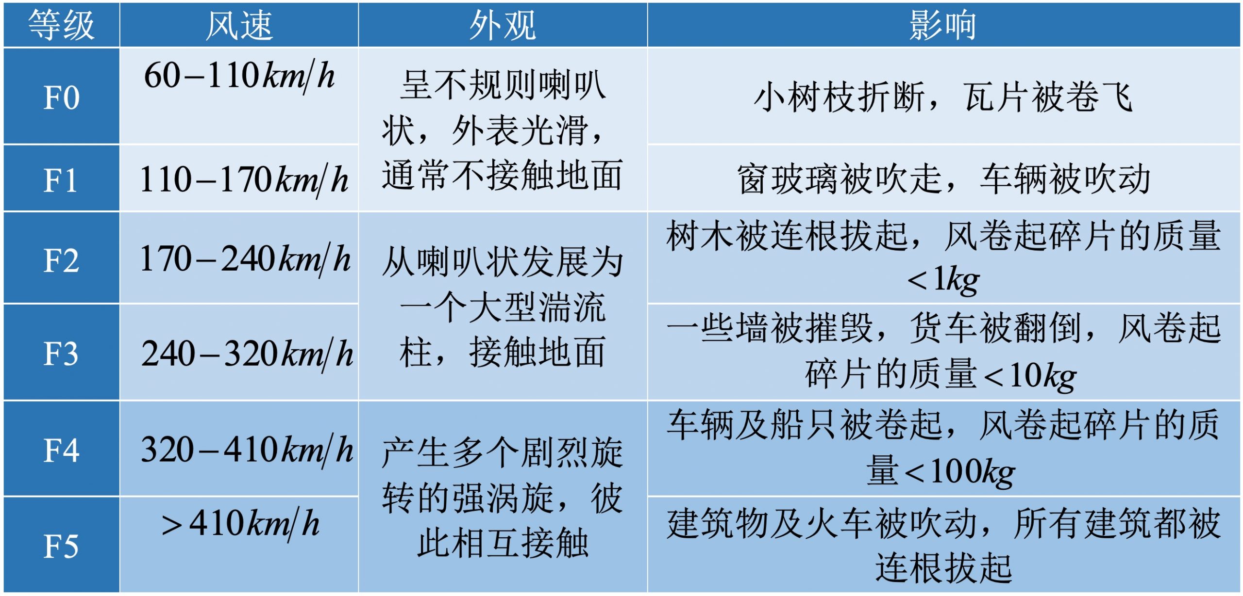
2. 不同程度的损害

  1981年,美国气象学家西奥多·T·藤田(Theodore T. Fujita)根据龙卷风造成的破坏和灾害,提出了一种强度等级表。

  表:T·T·藤田(1981)[1]提出的龙卷风强度分级

环境百科全书-龙卷风-龙卷风强度分级

3. 龙卷风的全球分布

  拜春季和初夏活跃的风暴活动所赐,横跨北美大陆中部,位于墨西哥湾、阿巴拉契亚山脉和落基山脉之间的大平原,是世界上龙卷风最频繁的地区,平均每年造成100人死亡,财产损失高达数亿美元。这一覆盖德克萨斯州北部、俄克拉荷马州、堪萨斯州和内布拉斯加州的危险地带被称为“龙卷风走廊”(Tornado Alley),每10000 km2的地区每年可发生5起龙卷事件。

  在全球范围内,受龙卷风影响的地区主要集中在中纬度。在北半球,欧洲、俄罗斯、印度和孟加拉国东部、中国沿海以及日本都曾观察到龙卷事件。在南半球,龙卷多发于澳大利亚南部和东部、南非,以及阿根廷北部和巴西南部之间。热带和赤道地区几乎不受龙卷风侵袭,但有时也会观察到海龙卷。

  在法国,让·德森斯(Jean Dessens)和约翰·T·斯诺(John T. Snow)[2]于1989年发表的气候学研究揭示了法国的三个龙卷高危地区:从普瓦图(Poitou)到皮卡第(Picardy)和香槟(Champagne)的西北狭长地带,东部的里昂(Lyonnais)和汝拉(Jura)之间,以及地中海沿岸。大多数龙卷风发生在5月到9月之间,此时雷暴活动较为频繁。但是,也有一些龙卷出现在冬天,这种龙卷一般与活跃的冷锋有关。平均而言,法国各省每年都会发生一到两次弱龙卷风(F0或F1等级)。强龙卷风(F3、F4或F5等级)险情似乎只在最活跃的地区出现,平均频率约5年一次。

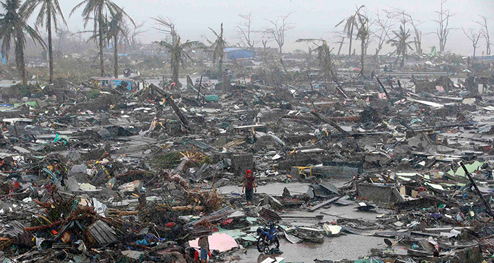
  2008年8月3日晚袭击法国北部省萨姆布雷山谷地区(Val de Sambre)的龙卷被列为F3或F4等级。其移动距离长达20 km,袭击了沿线多个城市,并在萨姆布雷河畔(Boussières-sur-Sambre)和豪蒙特(Haumont)达到最大强度。此次龙卷灾害造成3人死亡,18人受伤,大量房屋被毁,经济损失约200万欧元。这是30多年来袭击法国最猛烈的龙卷风。

4. 旋风中心

  涡旋的运行机制是什么?在当前的空气情况下(详见《焦点》),涡度是最根本的机制。涡度(vorticity)是一种矢量,是局地流体旋转速度的量度,单位为转每秒。涡旋就是流体中具有较大涡度的区域,涡旋轴是指向涡旋矢量点的方向。风速或风向的横向变化也会产生环境涡度。

  涡度在方向或强度上发生变化,有以下几个原因。首先,涡度可以通过空气运动水平或垂直地输送,这是流体的一个特征,称为平流(advection)。速度变化在涡旋的演变中起着双重作用:一方面,就像滑冰者会通过收紧或伸长手臂来加快或减缓其旋转一样,当风有辐合或辐散时,涡度也会增大或减小,这就是辐合效应(convergence effect)。另一方面,水平或垂直切变,即风分量的横向变化,会导致涡度方向的变化,但不会改变其强度,我们称之为倾侧(inclination)。因此,假定有一个由水平气流输送的水平轴涡旋,当气流向垂直方向倾斜时,其轴也逐渐垂直。如果空气的流动速度和温度在不同方向上同步发生变化,由于斜压效应(baroclinic effect),涡旋也会增强。此外,还要考虑由于湍流过程和地面摩擦而产生的耗散(dissipation)效应,其往往会减少涡度的空间变化。

  要研究龙卷风的形成和演变,首先要探究大气中涡度的来源,以及其如何集中于水平尺寸小于一公里的涡旋中。以下几种现象相伴出现。第一个来源是地球的自转,能够产生垂直方向的涡度,其强度随纬度而变化,最大值在两极点,每24小时旋转一圈,最小值在赤道,每24小时旋转零圈。但仅凭环境涡度的大小远不足以解释龙卷,因为典型的龙卷风涡度为每几秒钟旋转1次,是地球环境涡度的10000倍。要想在此基础上通过上述过程产生龙卷,需要的时间比风暴的平均寿命(最多几个小时)长得多。

  涡度的第二个来源,也是更重要的能量源,是水平风在风速和风向上的垂直切变。水平风速在垂直10000米的距离内变化20 m/s,即可产生2 10-3 s-1的涡度。这个涡度值意味着约一小时便可完成一次旋转,是地球在极点自转速度的25倍。这种水平环境涡度如发生垂直倾斜,即可激发有利于龙卷产生的强大涡旋运动,然后通过辐合运动,进一步加强涡旋运动,并通过上升和下沉气流将涡旋上下输送。

环境百科全书-龙卷风-成对的气旋和反气漩涡的形成
图2.在水平风垂直切变的环境中,上升气流的发展导致了成对的气旋和反气旋涡的形成。
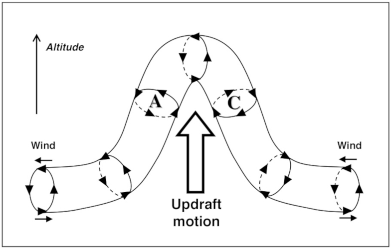
(altitude海拔高度,wind风,updraft motion上升运动)

  在涡度方面,在水平风垂直切变的环境中,上升气流的发展(如雷暴过程的上升气流)通过倾侧效应,造成环境涡旋轴的变形(图2),产生一对气旋和反气旋涡。但这两个方向相反的旋风的命运却各不相同。事实上,风切变一般不是恒定的,往往随着高度的变化,风向也发生转变。因此,北半球对流层低层的东南风,到了中层可发展为西南风,到了高空则可发展为风速更高的西北风。在此情况下,气旋移动造成的气压扰动,会产生一种垂直驱动力,该驱动力在低压侧增加上升气流,同时在高压侧减弱上升气流,直至其迅速消失。很快,上升气流的涡度就与其速度平行,形成稳定的贝尔特拉米流动(Beltrami flow),其不仅稳定,而且抗湍流耗散。

环境百科全书-龙卷风-龙卷风出现在上升气流和下沉气流的交界处
图3.龙卷风出现在上升气流和下沉气流的交界处,风和温度梯度最大的位置。
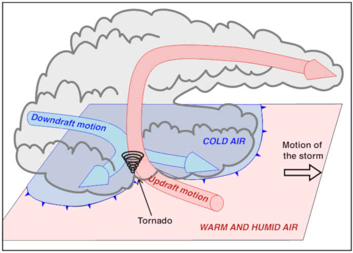
(downdraft motion下沉运动,updraft motion上升运动,tornado龙卷,motion of the storm风暴运动,warm and humid air暖湿空气,cold air冷空气)

  在初始阶段,上升气流改变涡旋的初始涡度,并对其进行垂直输送。而后,下沉气流的发展标志着涡旋发展开始了一个新的阶段。在这一阶段,一方面,涡度中心停止上升,并下降到较低的高度。另一方面,冷暖空气间水平方向上的风和温度的梯度均变大,加强了冷暖交界处的涡旋(图3)。

  这时,云墙出现,从云底开始发育,向着地面旋转生长,并逐渐演变为肉眼可见的旋转状态。这一结构宽约几百米,其出现标志着强旋风即将发展为龙卷。云墙旋转周期为几分钟,涡度为10-2至10-1 s-1,是风切变阶段的10到100倍,旋转风速达到50-100 km/h。涡旋被集中于上升气流和下沉气流之间、云墙和地面之间的区域,并在这一充满强降水、强阵风和持续雷电活动的区域形成龙卷。

  风暴演化过程中,下沉气流不断向下输送较冷的空气团,使得低层冷空气增加,进一步抑制了上升气流向上输送的温暖潮湿的空气。随着后者逐渐消失,风暴内的涡旋强度逐渐减小。失去了其强化机制的涡旋因冷空气的发展而变形,龙卷风也由此在拉伸和波动后逐渐消散。然而,短暂的间隔后,雷暴活动便可卷土重来,并由于风切变再次产生环境涡度的倾侧、辐合和输送。因此,在同一雷暴活动的传播过程中,经常观察到连续发生的龙卷风,这也使得龙卷造成的灾害更为可怖。

5. 龙卷的剖面

  风暴产生的涡旋的强度,决定了龙卷风出现的可能性和破坏力。然而,由于涡旋尺度过小(最多几十到数百米),再加上附近呼啸的强风,很难对其进行准确的观测。因此,目前与其有关的资料主要是通过光学手段(摄影测量),以及勇敢的实验人员在周边部署的移动气象雷达获得的。近年来,高分辨率的数值模拟也为研究人员提供了有用的信息。

环境百科全书-龙卷风-低、中和高强度龙卷风
图4.低(图a)、中(图b)和高强度龙卷风的特征。
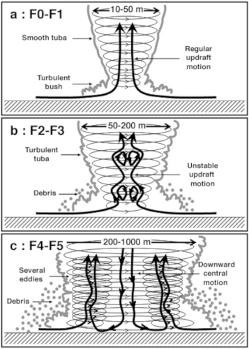
(smooth tuba光滑喇叭状外表,regular updraft motion规则上升运动,turbulent bush湍流层,turbulent tuba出现湍流的喇叭状外表,unstable updraft motion不稳定上升运动,debris碎片,several eddies多个漩涡,downward central motion中心下沉运动)

  低强度龙卷(F0到F1等级),外表光滑,呈喇叭状,其中心有一个上升气流(图4a)。气流流动非常规则,空气以恒定的角速度旋转,就像固体一样。这种情况称为朗肯涡旋(Rankine vortex)。

  中等强度龙卷(F2到F3等级),喇叭状的外表开始出现湍流(图4b)。在高空形成数个非连续区域,这些区域具有沿中轴向下的垂直速度。随着强度的增加,这类区域的数量也不断增加,并朝着地面方向发展,喇叭状外观也随之开始扩张、产生波纹。

  高强度龙卷(F4或F5等级),下沉气流向下运动到环流中心(图4c),气流的圆柱对称性逐渐消失,通常会在距轴几十米或几百米处形成围绕中心轴旋转的次级涡旋。龙卷强度越大,次级涡旋的数量越多,在最强大的龙卷中,最多可同时出现六个次级涡旋。然而,它们被裹挟于强风从地表卷起的各种碎片中,很难从视觉上分辨。强风是这些涡旋共同作用的结果,这也解释了高强度龙卷强大的破坏力。

6. 如何自保?

  除非你住在美国中部的“龙卷风走廊”,否则遇到龙卷风的概率很低。但即便如此,知道如何处理这些危险现象也是非常有用的。虽然低强度龙卷风(F0和F1)的旋风较为不剧烈,但它们可能吹落树枝或瓦片,甚至推翻轻型建筑物,依然容易引发人身或财产事故。如果你在风暴中看见一个圆锥形旋风从云底向地面发展,那便是龙卷形成的迹象,此时,最好的方法就是寻求一个坚实建筑的庇护。

  中等强度(F2和F3)和高强度(F4和F5)的龙卷风具有更严重的实质性后果,甚至可能危及人的生命。它们的主要特征是旋转开始出现湍流,以及碎片涡旋宽度增加。同时,该强度的龙卷还伴有类似于火车经过或飞机起飞的巨大噪音。首先,龙卷风风暴蔓延非常迅速,速度高达100 km/h。所以,当附近发生龙卷风时,最好是在现场保护自己,而不是试图逃跑。哪怕你能够开车逃离,龙卷风最终也会赶上你。

  建筑物的地基和地窖可提供最好的保护。如果没有条件,可以退而求其次,躲藏在最中间的房间,用毯子或床垫保护自己。最重要的是,避免站在门窗附近,因为门窗很容易被强风刮掉或砸碎,而后将你暴露在高速飞舞的碎片中。如实在找不到坚实的庇护所,可以躺进槽状物体,用手臂护住头,越紧越好。无论如何,切忌呆在容易被龙卷风带走和摧毁的物体中,如汽车、卡车、大篷车、移动房屋等,这些地方不能为你提供足够的保护。然而不幸的是,这是大多数受害者犯下的致命错误,他们错误地认为这些地方是安全的。


参考资料及说明

[1] T. Fujita, 1981: Tornadoes and Downbursts in the Context of Generalized Planetary Scales. J. Atmos. Sci. , 38, 1511-1534.

[2] Dessens and J.T. Snow, 1989: Tornadoes in France. Weather Forecasting, 4, 110-132


环境百科全书由环境和能源百科全书协会出版 (www.a3e.fr),该协会与格勒诺布尔阿尔卑斯大学和格勒诺布尔INP有合同关系,并由法国科学院赞助。

引用这篇文章: ROUX Frank (2024年2月24日), 龙卷风:强大的毁灭性涡旋, 环境百科全书,咨询于 2024年7月27日 [在线ISSN 2555-0950]网址: https://www.encyclopedie-environnement.org/zh/air-zh/tornadoes-powerful-devastating-eddies/.

环境百科全书中的文章是根据知识共享BY-NC-SA许可条款提供的,该许可授权复制的条件是:引用来源,不作商业使用,共享相同的初始条件,并且在每次重复使用或分发时复制知识共享BY-NC-SA许可声明。

Tornadoes: powerful devastating eddies

Encyclopédie environnement - tornades - couverture

The strongest winds on Earth are due to tornadoes, causing devastation unmatched by any other phenomenon where they strike. The thunderstorms that give rise to them have very specific characteristics that are found in the central United States, but also in other mid-latitude regions. Most of the physical mechanisms that contribute to the intensification of these powerful atmospheric eddies are known. This makes it possible to predict the risks fairly accurately. However, the exact location and actual strength of tornadoes generated by a storm cannot be known precisely in advance. Also, although these extreme events are rare, it is useful to know how to protect yourself in the event of a possible encounter with such weather monsters.

1. A phenomenon as brief as it is intense

The strongest winds on Earth, with speeds up to and even exceeding 400 km/h, are due to tornadoes. These violent phenomena leave impressive traces of torsion, suction, tearing, lifting, signs of converging, ascending and swirling movements. The destruction that accompanies them is always considerable, sometimes with loss of human life. Tornado detection is difficult, which does not allow effective alerts to be issued, but it is possible to identify a potential risk when the atmosphere is very unstable with a very changing wind depending on altitude.

Encyclopédie environnement - tornades - tornadoes
Figure 1. A high-intensity tornado on June 22, 2007, near the village of Elie in Manitoba, Canada. [Source: Photograph of Justin Hobson]
A tornado is an atmospheric whirlwind of strong winds, near-vertical axis and cyclonic direction (counter-clockwise in the northern hemisphere, clockwise in the southern hemisphere), whose visible part extends like a vertical column or cone, the Tuba. This vortex is located under the base of a developed convective cloud, cumulonimbus or more rarely cumulus congestus (Figure 1). Tornadoes occur in the central part of storms, and are often accompanied by heavy rains, hail and intense electrical activity.

The diameter of the tuba varies from a few ten to a few hundred meters. Its visible vertical extension ranges from a few hundred metres to 2-3 kilometres, but its upper part hidden in the cloud mass extends much higher, up to altitudes of 8-10 kilometres. The lifecycle of a tornado is quite short, a few minutes at most, but the rapid movement of the violent storms that give rise to them explains why their impact on the ground can extend over several kilometres. In addition, storms often go through cycles of dissipation and redevelopment. They can thus successively give birth to several tornadoes, more or less powerful.

How do you recognize the birth of a tornado? One of the main warning signs of tornado development is the almost simultaneous appearance of an outgrowth below the base of the cloud and a strong swirl of dust on the ground. A snorkel then appears between these two points. It is made visible by the condensation of atmospheric humidity into liquid water droplets due to the pressure drop associated with the vortex. Initially fluctuating, the tuba stabilizes in a vertical position and widens as it intensifies. The most powerful tornadoes have a very turbulent appearance, accompanied by a dark mass of debris of all kinds raised by strong winds. Waterspouts are tornadoes that occur over liquid surfaces (seas or lakes), they follow about the same evolution as low-intensity tornadoes. The foot of a waterspout is surrounded by a foam ring about ten metres high, similar to the bush of dust and debris at the base of ground tornadoes.

2. More or less significant damage

In 1981, American meteorologist Theodore T. Fujita proposed an intensity scale to classify tornadoes based on the damage and destruction they cause.

Table: Tornado intensity scale according to T.T. Fujita (1981) [1]

3. Global distribution of tornadoes

The great plains that stretch across the central North American continent, between the Gulf of Mexico, the Appalachians and the Rockies, are the region in the world where tornadoes are most frequent, associated with very high storm activity in the spring and early summer. They are responsible for the deaths of an average of 100 people per year and cause hundreds of millions of dollars in damage each year. In northern Texas, Oklahoma, Kansas and Nebraska, an area at risk is known as Tornado Alley, where 5 events per year can occur per 10,000 km2 area.

Globally, the areas affected by tornadoes are mainly in mid-latitudes. In the northern hemisphere, these phenomena are observed in Europe and Russia, east of India and Bangladesh, in the coastal part of China and in Japan. In the southern hemisphere, tornadoes occur in South and Eastern Australia, South Africa and between northern Argentina and southern Brazil. Tropical and equatorial areas are more spared, but waterspouts are sometimes observed.

In France, the climatological study by Jean Dessens and John T. Snow [2], published in 1989, reveals three more exposed areas: the northwest in a strip of land from Poitou to Picardy and Champagne, the east between Lyonnais and Jura, and the Mediterranean coast. Most tornadoes occur between May and September, a period of frequent thunderstorm activity. However, some of them are observed in winter, in connection with the passage of particularly active cold fronts. On average, there are one to two weak tornadoes (of F0 or F1 intensity) per year and per department. The risk of strong tornadoes (F3, F4 or F5) seems limited to the most active regions, with an average frequency of one event every 5 years or so.

The event that struck the Val de Sambre, in the northern department, on the evening of 3 August 2008 was thus analysed as a tornado of category F3 or F4. Following a trajectory of about twenty kilometres, the tornado hit several municipalities, with maximum intensity in Boussières-sur-Sambre and Haumont. Three people died, eighteen were injured, and many homes were destroyed. The amount of the devastation was estimated at around € 2 million. To date, it is the most violent tornado to hit France in more than 30 years.

4. In the heart of the whirlpools

What is the mechanism of the vortices? Everything is based on vorticity, a vectorial quantity that measures locally the rotation of a fluid flow, in this case air (see Focus); it is measured in revolutions per second. A vortex is a region of fluid with a strong vorticity. The vortex axis is the direction towards the vortex vector points. Transverse variations in wind speed or direction can also lead to ambient vorticity.

Vorticity can vary in direction or intensity for several reasons. First this quantity can be transported horizontally or vertically by the movements of the air as a characteristic of the fluid, this is called advection. Speed variations play a dual role in the evolution of the vortex: much as skaters accelerate (or slow down) their rotation by tightening (or widening) their arms, vorticity intensifies (or decreases) when there is convergence (or divergence) of the wind, it is the convergence effect. On the other hand, horizontal or vertical shearings, i.e. transverse variations of wind components, cause changes in the direction of vorticity without modifying its intensity, we call it inclination. Thus a vortex of horizontal axis transported by a horizontal flow sees its axis gradually become vertical when the flow tilts towards the vertical. The vortex can also intensify in the presence of simultaneous variations, and in different directions, of the air velocity and temperature, through the baroclinic effect. It is also necessary to take into account the dissipation effect due to turbulent processes and surface friction that tend to reduce spatial variations in vorticity.

Studying the formation and evolution of tornadoes requires describing the sources of vorticity in the atmosphere and then their concentration in eddies with horizontal dimensions less than one kilometre. Several phenomena follow one another. The first source of vorticity is the rotation of the Earth and is a source of vertical axis vorticity whose intensity varies with latitude. It is maximum at the poles with a rotation per 24 hours, and zero at the equator. But the tornadoes cannot be explained by the concentration of this ambient vorticity because the time required to reach the typical values of tornadoes – 1 rotation per few seconds, i.e. amplification by a factor greater than 10,000 – by one of the processes mentioned above would require much longer times than the average lifetime of storms (a few hours at most).

The second source of vorticity, which is a more important reservoir is the vertical shear of the horizontal wind, in intensity or direction. Thus, a wind speed variation of 20 m/s over a vertical distance of 10,000 m gives a vorticity of 2 10-3 s-1. This value is equivalent to a period of about one hour to complete a complete lap. This is already 25 times faster than the Earth’s rotation at the pole. The powerful vortex motion associated with tornadoes results from the vertical inclination of this ambient horizontal vorticity, then its amplification by converging movements, and its transport to altitude or to the ground by ascending and descending currents.

updraft - tornadoes
Figure 2. The development of an updraft in an environment subject to vertical shear of the horizontal wind leads to the formation of a doublet of cyclonic and anticyclonic eddies.

In terms of vorticity, the development of an updraft – such as that accompanying the development of a thunderstorm – in an environment subject to vertical shear of the horizontal wind produces a deformation of the axis of the ambient vortex by the tilting effect (Figure 2). The updraft is then associated with a doublet of cyclonic and anticyclonic eddies. But these two whirlwinds of opposite directions do not have the same destiny. Indeed, wind shear is generally not constant, often changing direction with altitude. Thus, in the northern hemisphere the wind can come from the southeast in the lower layers, from the southwest in the middle troposphere and from the northwest with a higher intensity at high altitude. In such a situation, the pressure disturbances associated with cyclonic movements generate a vertical force that amplifies the updraft, while they attenuate it on the high-pressure side, which disappears quite quickly. Soon the vorticity of the updraft angles parallel to its speed, forming a stable Beltrami flow stable and resistant to turbulent dissipation.

tornadoes
Figure 3. A tornado appears at the interface between the updrafts and downdrafts, at the location of the high contrast of wind and temperature.

After an initial phase of concentration and vertical transport of the cyclonic vortex associated with the updraft, the development of the downdraft opens a new phase. On the one hand, the maximum vorticity ceases to ascend and descends to lower altitudes. On the other hand, the strong contrast of horizontal wind and temperature between warm and cold updrafts strengthens the vortex at their interface (Figure 3).

At this moment the wall cloud appears, a rotational growth that develops under the base of the cloud and whose rotation begins to be visible to the naked eye. This structure, a few hundred meters wide, is the mark of a powerful whirlwind ready to give birth to a tornado. Its rotation period is a few minutes, with a vorticity of 10-2 to 10-1 s-1 (10 to 100 times more intense than that associated with wind shear, and a swirling wind speed of 50 to 100 km/h). The tornado forms between the cloud wall and the ground by concentrating the vortex between updrafts and downdrafts in an area of heavy precipitation, violent gusts, and generally sustained electrical activity.

The gradual intensification of the downdraft during the evolution of the storm increases the amount of cold air in the lower layers, which further reduces the supply of warm, moist air to the updraft. The latter gradually fades away, and the intensity of the vortex decreases within the storm. Deprived of its amplifier mechanism and deformed by the progression of cold air, the tornado gradually dissipates after being stretched and undulated. But thunderstorm activity can redevelop a little later and generate again the process of inclination, concentration and transport of ambient vorticity related to wind shear. Thus, it is not uncommon to observe successive occurrences of tornadoes during the propagation of the same thunderstorm, multiplying the damage caused.

5. Anatomy of tornadoes

The appearance and destructive power of a tornado depends on the intensity of the vortex generated by the storm. However, due to its small size (a few dozen to a few hundred metres at most), and the strong winds blowing there, it is not easy to make accurate observations. Current knowledge therefore comes mainly from remote observations by optical means (photogrammetry) or by means of mobile meteorological radars deployed in the vicinity of these dangerous phenomena by intrepid experimenters. In recent years, very high resolution numerical simulations have also provided useful information.

tornadoes
Figure 4. Characteristics of tornadoes of low (a), medium (b) and high intensity.

Low intensity tornadoes (F0 to F1 scale) have a smooth looking tuba with an upward flow in their center (Figure 4a). The flow is rather regular and the air is rotated at a constant angular velocity, like that of a solid body. This situation is called the Rankine vortex.

For medium tornadoes (F2 to F3 scale), the tuba has a more turbulent appearance (Figure 4b). Areas of disbonding where vertical velocity becomes downward along the central axis are formed at high elevations. As intensity increases, these regions become more numerous and progress towards the ground surface, associated with tuba expansion and ripples.

In high-intensity tornadoes (F4 or F5 scale), the flow is downward to the centre of the circulation (Figure 4c). The cylindrical symmetry of the flow gradually disappears and secondary eddies frequently form a few tens or hundreds of metres from the axis, rotating around the central axis. Their number increases with the intensity of the tornado, up to six can be counted at the same time for the most powerful tornadoes. Nevertheless, it is difficult to visually distinguish these multiple eddies within the vast set of debris of all kinds ripped off the surface by strong winds. In such situations, winds result from the combination of all these rotational movements, which explains the importance of the devastation caused by the most powerful tornadoes.

6. How to protect yourself?

Even if the probability of encountering a tornado is quite low – unless you live in the Tornado Alley in the central United States of America – it is useful to know what to do about these dangerous phenomena. While low-intensity tornadoes (F0 and F1) are in fact only slightly violent swirling gales, they are nevertheless likely to cause material or physical accidents through falling branches or tiles, or overturning light constructions. When, during a storm, a conical growth develops from the base of a cloud to the ground, a sign of the formation of a tornado, it is therefore advisable to seek the shelter of a solid construction.

Tornadoes of medium (F2 and F3) and especially strong (F4 and F5) intensity have much more serious material consequences and can endanger human lives. They are mainly distinguished by the turbulent nature of the tuba and the width of the debris vortex. They are also accompanied by loud noise, similar to that of a train passing or an aircraft taking off. First of all, tornado storms spread very quickly, at speeds of up to 100 km/h. Also, when a tornado occurs nearby, it is always better to protect yourself on the spot, rather than trying to escape, even in a vehicle, because the tornado can eventually catch up with it.

The best protection is that provided by the foundations of a building or cellars. If this is not possible, seek shelter in the most central room, protecting yourself with blankets or mattresses. Above all, avoid standing near doors and windows, which are easily torn off and sprayed by strong winds, and which expose you to debris thrown into the air at very high speeds. When there is no hard shelter, some protection can be found by lying down in a trough and protecting your head with your arms to provide as little grip as possible in strong winds. In any case, it is especially important to avoid staying in a structure that does not offer sufficient protection, such as cars, trucks, caravans, mobile homes, easily carried away and destroyed by tornadoes. Unfortunately, this is the fatal mistake made by most victims who mistakenly believe they are seeking refuge there.


References and notes

[1] T.T. Fujita, 1981: Tornadoes and Downbursts in the Context of Generalized Planetary Scales. J. Atmos. Sci. , 38, 1511-1534.

[2] J. Dessens and J.T. Snow, 1989: Tornadoes in France. Weather Forecasting, 4, 110-132


环境百科全书由环境和能源百科全书协会出版 (www.a3e.fr),该协会与格勒诺布尔阿尔卑斯大学和格勒诺布尔INP有合同关系,并由法国科学院赞助。

引用这篇文章: ROUX Frank (2019年7月16日), Tornadoes: powerful devastating eddies, 环境百科全书,咨询于 2024年7月27日 [在线ISSN 2555-0950]网址: https://www.encyclopedie-environnement.org/en/air-en/tornadoes-powerful-devastating-eddies/.

环境百科全书中的文章是根据知识共享BY-NC-SA许可条款提供的,该许可授权复制的条件是:引用来源,不作商业使用,共享相同的初始条件,并且在每次重复使用或分发时复制知识共享BY-NC-SA许可声明。