Riparian vegetation communities along watercourse provide specific habitats at the land-water boundary, where water, sediment and energy flows interact with the vegetation itself. River dynamics is at the origin of ecological and hydromorphological processes responsible for the high spatial and temporal variability of environmental factors. Biodiversity varies longitudinally from source to mouth and transversely from open water areas to backwaters periodically flooded by floods. It is also closely dependent on underground flows. As rivers are highly responsive to climate change and human activities affecting watersheds, most rivers have been artificially regulated over the past two centuries. The result has been a significant erosion of biodiversity, the restoration and management of which nowadays requires the search for a sustainable river dynamic and guaranteeing the regular renewal of riverine habitats.
Alluvial plant communities are transitional areas between aquatic and terrestrial environments that are constantly being remodelled by river activity [1]. Under the pressure of imposed constraints, plants have developed adaptive responses that allow them to settle, develop and reproduce in these habitats subject to the influence of water, energy and material flows [2]. Adaptive responses are expressed as:
highly developed root systems that effectively fix deposits and resist erosion and current;
an ability to recover from the stems and branches buried in the sediments;
an ability to rapidly colonize favourable environments by vegetative reproduction (rhizomesA more or less elongated perennial underground stem, branched or not, provided with leaves reduced to the state of very small scales, emitting adventitious roots each year and an apical bud that gives rise to an aerial stem, slightly buried in the ground in which it grows horizontally or flush with the surface.) and by dispersing many seeds by water and wind.
physiological adaptations to withstand prolonged periods of anoxia.
Plants thus resist the stress imposed by floods, whose frequency, intensity, extent and timing of the biological year in which they occur are highly variable. The ability of the river to create new environments through river dynamics explains the high biodiversity because various habitats are then made available. The plants found there, such as willows and poplars for example, are closely dependent on disturbance for their spread and reproduction. Plant development after germination is linked to the presence of exuberant depositsto be exempted: to emerge after a flood and to be stable over periods ranging from the biological year for annual pioneer species to the century for perennial species in mature hardwood alluvial forest.
2. Spatial and temporal organization of the riparian landscape
In addition, the riparian landscape is still in a state of transition between an old state that can be reconstructed and a future state that is difficult to predict.
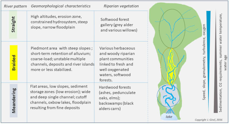
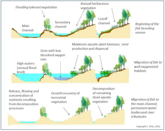
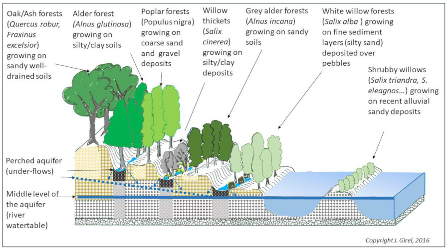
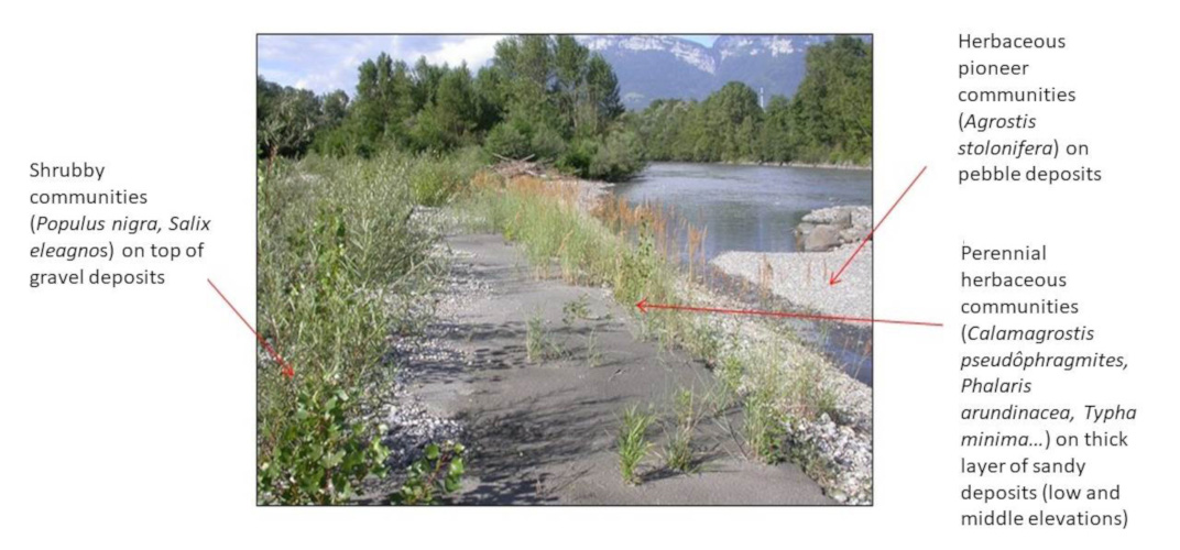
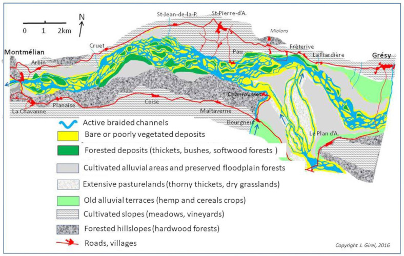
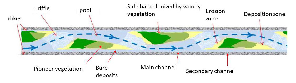
The zonation. The deposits produced by a dynamic watercourse are composed of clay, silt, sand, gravel and pebbles in varying proportions. They have thicknesses and structures that explain the presence of a mosaic of habitats also characterized by surface and subsurface hydrology (see also Figure 4). Species replace and organize themselves according to local environmental conditions. As with succession, the areas are highlighted by one or more dominant species (Figure 6).
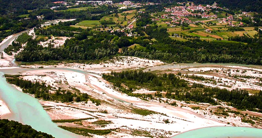
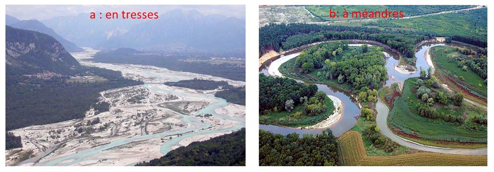
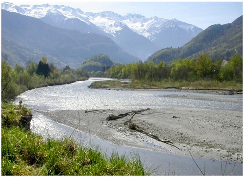
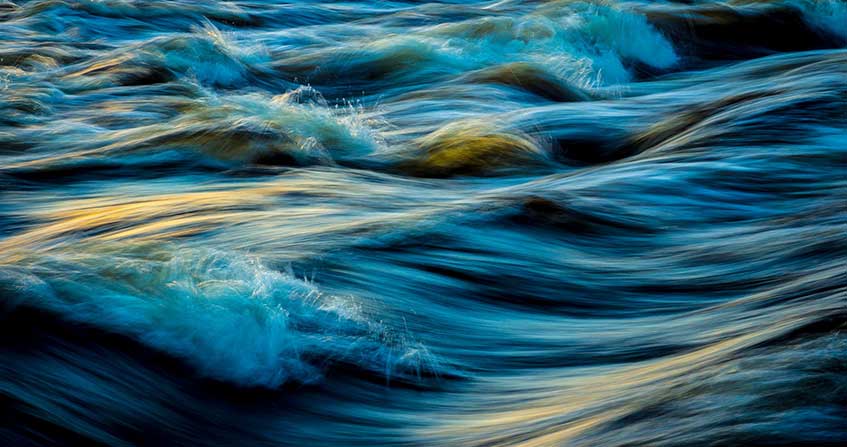
Figure 7. Tagliamento, Italy, braided stream (a, left); La Morava, Czech Republic, meandering stream (b, right). [Source: photographs J. Girel and X]When the river discharges are high and bedload material in small quantities, the transport capacity of the watercourse exceeds the energy consumed. This results in a deepening of the bed, an elongation of the river course, a lowering of the slope and the formation of meanders. Floods deposit fine materials from the suspended load. This river pattern is characterized by habitats that support species such as black alder, alder buckthorn or grey willow, adapted to slow, low-oxygenated waters and compact soils (Figures 2 and 7b).
19th century: modifications to the structure of the alluvial landscape. In the 19th century, braided rivers were diked and fluxes (water, sediment and energy) were controlled by diversion, warping and drainage works that altered the floodplain area located outside the diked channel [9].
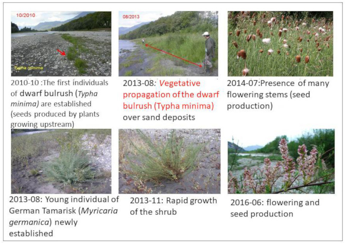
20th century: erosion of biodiversity. In watersheds, declining precipitation and the vegetalization of bare land have had an impact on river dynamics since the beginning of the 20th century. Reduced runoff on stabilized slopes limits erosion; in addition, much of the sediment is stored upstream in hydroelectric reservoirs. The result is a coarse load deficit that results in bed deepening, accentuated by gravel extraction from rivers. There is then a stabilization of lateral deposits. The annual floods, mitigated by dams, are no longer sufficient to mobilize the bedload that can renew hydromorphological landforms. On the other hand, ten-years floods occurring during the vegetative period create spectacular aggradation increasing the stability of river islands and side bars. This results in a loss of biodiversity by homogenization of vegetation remaining at the woody stages characteristic of the end of the plant-succession. Early succession plants such as the dwarf bulrush, linked to dynamic watercourses, are threatened with extinction. The same applies to willows (six species present), german tamarisk, sea buckthorn, black poplar and grey alder, a tree typical of the Alpine foothills. Heterogeneously structured alluvial communities, composed of native species with natural self-regeneration, are giving way to homogeneous, stable and highly exotic species-impregnated communities.
21st century: revitalizing watercourses. Afforestation of river islands and side bars reduces the capacity of the diked channel, which is no longer able to provide transit during exceptional floods. The protection of highly anthropized alluvial floodplains requires appropriate development. Where possible, the river’s freedom space can be extended or retention basins can be created outside the dikes in areas reserved for alluvial forest, poplar plantations or wet grasslands and marshes. However, deforestation and levelling of river islands remains a necessary step to ensure the safety of people and property and the conservation of biodiversity. Within the channel, biological richness effectively depends on the creation of bare spaces where the initial phases of plant succession will begin. Large trees that can generate big debris jams are prohibited.
Climate, alpine colonization and development of braiding. In the case of alpine rivers, there has been shown a significant increase in the volume of coarse materials transported during the Iron Age (2700/2400 BP), the post-Roman period (500-700 AD) and the Little Ice Age (1550-1850). With the increase in rainfall, human activities, such as deforestation and the development of agriculture on the slopes, were the main causes. These changes were then at the origin of the braiding process proved by the paleochannels recorded in the sediment levels dated from these periods [14].
Old maps and representation of a reference state. During the Little Ice Age, the piedmont rivers presented the full range of habitats (about forty plant communities) associated with the so-called “braided system with vegetated islands”. This diversity represented by the 18th and 19th century maps (see Figure 8 and [9]) suggests that the braided system offers all the features of the reference mode [15] for the renaturation of the Alpine floodplains. Returning to a natural state is highly debatable here because many communities with high biodiversity are the result of human exploitation of plants [16]. Moreover, for socio-economic reasons, restoring the landscape prior to diking works is utopian.
Future of alpine alluvial biodiversity. One of the major issues related to global warming will be water management and its impacts on river ecology. If the policy of renaturation of the alluvial plains by increasing the reserved flows [12] was not pursued, it would be necessary to expect a significant change in the spatial organization and biodiversity of riparian landscapes.
[1] Concept of permanent habitat renewal in the mosaic (Shifting Habitat Mosaïc = SHM); Stanford J.A., Lorang M.S. & Hauer F.R. (2005) The shifting habitat mosaic of river ecosystems. Verhandlungen der Internationalen Vereinigung für theoretische und Angewandte Limnologie, 29, 123-136.
[2] Hauer F.R., Locke H., Dreitz V.J., Hebblewhite M., Lowe W.H., Muhlfeld C.C., Nelson C.R., Proctor M.F. & Rood S.B. (2016) Gravel-bed river floodplains are the ecological nexus of glaciated mountain landscapes. Science Advances, 2(6), 1-13.
[3] Intermediate disturbance hypothesis; Wilkinson D.M. (1999) The Disturbing History of Intermediate Disturbance. Oikos 84(1), 145-147.
[4] River Continuum Concept (RRC); Vannote R.L., Minshall G.W. & Cummins K.W. (1980) The river continuum concept. Canadian Journal of Fisheries and Aquatic Sciences, 37, 130-137.
[5] Prunier P., Bonin L. & Frossard P.-A. (2013) Guide des espèces in: Interreg France-Suisse, Programme “GeniAlp” Génie végétal en rivière de montagne, 318 pages.
[6] Flood Pulse Concept (FPC); Junk W.J., Bayley P.B. & Sparks R.E. (1989) The flood-pulse concept in river-floodplain systems. Canadian Special Publication of Fisheries and Aquatic Sciences, 106, 110-127.
[7] Bravard J.-P. (2016) La longue durée des métamorphoses fluviales, in Bethemont J. & Bravard J.-P. « Pour saluer le Rhône », Ed. Libel, Lyon, 50-61
[8] Beechie T.J., Liermann M., Pollock M.M., Baker S. Davies J.R. (2006) Channel pattern and river-floodplain dynamics in forested mountain river systems. Geomorphology, 78(1-2):124-141.
[9] Girel J. (2016) La vallée de l’Isère entre Albertville et Grenoble: un paysage alluvial lié aux aménagements hydrauliques du XIXe siècle et à leurs impacts. in : P. Fournier & G. Massard-Guilbaud, (Dir), Aménagement et Environnement, Perspectives historiques, Collection “Histoire”, Presses Universitaires de Rennes, 149-161.
[10] Girel J., Garguet-Duport B. Pautou G. (1997) Present structure and construction processes of landscapes in Alpine floodplains. A case study: the Arc-Isère confluence (Savoie, France). Environmental Management, 21(6), 891-907.
[11] Girel J. (2010) Histoire de l’endiguement de l’Isère en Savoie : conséquences sur l’organisation du paysage et la biodiversité actuelle. Géocarrefour, 85(1), 2010, p. 41-54.
[12] Mandatory minimum water flow (expressed as a percentage of the average total flow) that the managers of a hydraulic structure (dam, weir, hydroelectric unit, etc.) must reserve for the watercourse and the minimum functioning of ecosystems.
[13] Merritt D.M., Scott M.L., Leroy-Poff N., Auble G.T. & Lytle D.A. (2010) Theory, methods and tools for determining environmental flows for riparian vegetation: riparian vegetation-flow response guilds. Freshwater Biology, 55(1), 206-225.
[14] Salvador P.-G. (1991) La métamorphose des cours du Drac et de l’Isère à l’époque moderne dans la région grenobloise (Isère, France). Physio-Geo. (Paris), 22/23, 173-178.
[15] Ward J.V., Tockner K., Edwards P.J., Kollmann J., Bretschko G., Gurnell A., Petts G.E. & Rossaro B. (1999) A reference river system for the Alps: the “Fiume Tagliamento”. Regulated Rivers: Research & management, 15, 63-75.
[16] Girel J. (2011) Les communaux dans une vallée alpine au XIXe siècle : Impacts de l’endiguement sur le statut, la productivité et les usages des délaissés alluviaux (exemple de l’Isère dans la Combe de Savoie) in: C. Beck, J.-M. Derex & B. Sajaloli (eds), Usages et espaces communautaires dans les zones humides, Collection Journées d’études, GHZH, P. de Maisonneuve, Vincennes, 89-106. http://ghzh.free.fr/.
[17] Galat D.L., Fredrickson L.H., Humburg D.D., Bataille K.J., Bodie J.R., Dohrenwend J. et al (1998) Flooding to restore connectivity of regulated large-river wetlands. BioScience, 48, 721-733. According to the concept of “String-of-Beads Restoration Concept” presented in this article, successively enlarged alluvial zones (such as pearls in a necklace) allow the proper functioning of the hydrogeomorphological and ecological processes at the origin of biodiversity.
[18] Till-Bottraud I., Poncet B.-N., Rioux D. & Girel J. (2010) Spatial structure and clonal distribution of genotypes in the rare Typha minima Hoppe (Typhaceae) along a river system. Botanica Helvetica, 120, 53-62.
The Encyclopedia of the Environment by the Association des Encyclopédies de l'Environnement et de l'Énergie (www.a3e.fr), contractually linked to the University of Grenoble Alpes and Grenoble INP, and sponsored by the French Academy of Sciences.
The articles in the Encyclopedia of the Environment are made available under the terms of the Creative Commons BY-NC-SA license, which authorizes reproduction subject to: citing the source, not making commercial use of them, sharing identical initial conditions, reproducing at each reuse or distribution the mention of this Creative Commons BY-NC-SA license.
Predicting and managing river flows is a necessity for flood control, water supply, agriculture and…
Christian LALLEMENT, Hydraulic engineer, retired from EDF, former Director of the Unité de Production Hydraulique Alpes, former President of the Commission Française de Normalisation de mesures de débits en rivière.
Crystalline rocks or “hard” rocks are generally ancient rocks of two main types: plutonic rocks,…
Patrick LACHASSAGNE, Head of Science and Expertise Water Resources. Water Resources and Sustainability Division. Danone Waters. Director of the Water Institute by Evian. Evian-les-Bains, France