The permafrost
PDF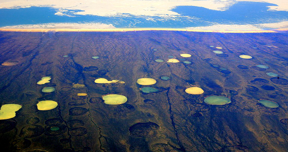
Permafrost is present on the Earth’s surface, particularly in the Northern Hemisphere. Its thickness and continuity depend on latitude and altitude. There are two main categories of permafrost: a thick, continuous permafrost that occupies the large areas of the continental shelves of Alaska, Canada and Siberia; and a thinner, often discontinuous or even sporadic permafrost, which concerns mountain ranges, particularly the alpine ranges. In these, rocky glaciers constitute a remarkable form, whose genesis and behaviour are the subject of special studies, different from those traditionally carried out on “real” glaciers. This article also discusses the risks associated with mountain permafrost in the context of climate change.
1. Definition and distribution of permafrost
The concept of permafrost (English name) or pergelisol (French name) was first defined in 1947 [1] and has since been an important part of cryospheric studies.
Permafrost is a thermal and temporal phenomenon that refers to subsurface terrain whose temperature never rises above 0°C for at least one year. It can affect all types of materials: bedrock, surface formations, soils. It may or may not contain ice: in rock, the amount of ice is generally limited to filling cracks, while in surface formations it may be important: fill the entire interstitial space (saturated permafrost), include small layers or lenses of ice, and exceed the proportion of rock material (supersaturated permafrost) by volume.
Permafrost represents about 20% of the Earth’s continental surface, or 25 million km2, a quarter of the land area of the Northern Hemisphere. By way of comparison, continental ice (excluding sea ice) covers 16 million km2.
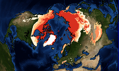
- the continuous permafrost zone (more than 80% of the surface area),
- the discontinous permafrost zone (between 30 and 80% of the surface area),
- sporadic permafrost (less than 30% of the surface),
- permafrost in isolated spots.
While most permafrost occurs at high latitudes, it is also found at high altitudes in mountainous areas. Thus in the Alps, a discontinuous permafrost is potentially present above about 2500 m in a northerly direction, a more continuous permafrost above 3500 to 4000 m. According to model calculations, permafrost could cover an area of 1300 km² in the French Alps [2], more than twice the surface area of glaciers (about 500 km²).
2. Structure of the permafrost
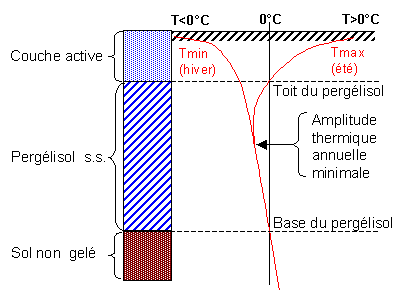
The formation, persistence or disappearance of permafrost depends very closely on the climate. Its distribution, temperature and thickness respond to changes in the natural environment and anthropogenic disturbances, resulting in a change in the ground’s thermal regime. The vertical structure of permafrost, in particular its ice content, is dependent on both climate and topographic, geological and geomorphological conditions (Figure 2).
On the typical thermal profile, three levels are clearly visible:
The surface layer, whose temperature exceeds 0°C in summer (and therefore thaws seasonally), is called the active layer. Strictly speaking, permafrost therefore only concerns the layer below the active layer, whose temperature remains permanently below 0°C. The active layer can be a few tens of centimetres thick in the peaty soils of the Arctic tundra, and up to 3 to 7 metres thick in ice-poor rocky terrain in the Alps.
The layer that never thaws is the permafrost in the strict sense. Below the level at which the maximum and minimum temperature curves meet (Tmin and Tmax) the terrain does not undergo annual oscillations in air temperature. This maximum penetration depth of annual variations is highly dependent on ice content. It can be as short as a few metres in ice-rich terrain, and as long as 20 to 30 metres in rocky terrain in the Alps.
The depth of the permafrost base is determined by the mean local air temperature, which conditions the permafrost air temperature, and by the geothermal gradient: the deepest permafrost thus corresponds to the coldest and driest climates (low snowfall shortens the insulating effect provided by snow). For example, the permafrost is several hundred metres deep in the far north of Canada or in Siberia. In the Alps, drilling carried out between 1998 and 2010 has shown that at an altitude of 3000 metres, permafrost can reach a thickness of more than 100 metres.
The interaction between the climate above the ground and the climate below its surface is complex and depends on multiple factors, many of which are sensitive to climate change. Thermal oscillations in the atmosphere are generally damped with depth due to the thermal conductivity of the subsoil and the snow cover. There is generally a time lag between changes in ground surface temperature and changes in depth in permafrost; in the case of a thick permafrost (North America, Siberia…), this lag can be in the order of hundreds to thousands of years, in that of a thin permafrost (Alps,…), it is counted in years or decades.
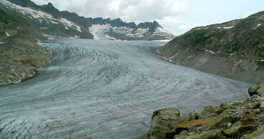
3. Permafrost and alpine rock glaciers
Any type of land is likely to be affected by permafrost, whether it is bedrock or sediment.
In the case of a rocky massif, we will be dealing with a rock that is more or less fractured and “cemented” by ice. The proportion of ice is limited to crack filling and may be almost nil in the case of a poorly fractured rock, but it can play a significant role in the stability of rock masses.
In the case of surface formations, permafrost is likely to be formed from rock debris (colluvium, moraine and scree) and ice (from snow compaction and avalanche flows and infiltration water freezing). The conditions under which this permafrost can form depend on the altitude (generally higher than 2500 metres in our temperate latitudes), the exposure and the geomorphological context (presence of glacier; presence of coarse detrital deposits acting as thermal insulation, or even as a cold trap, for the ground) and topography (shading effect, cold air bowl, etc.).
The standard structure of a permafrost in surface formations is composed of:
- a permanently unfrozen surface layer that can reach a thickness of a few metres, which is not very thermally conductive and corresponds to the active layer,
- a layer of permafrost, a mixture of ice and rock debris, sometimes homogeneous (“ice concrete” saturated with 30 to 40% ice), also including local heterogeneities (permafrost “supersaturated” with ice lenses, permafrost “undersaturated” containing a little air and melting ice; channels and pockets” of melting water…),
- the bedrock itself (rarely frozen) or a third layer of unfrozen and unsaturated debris.
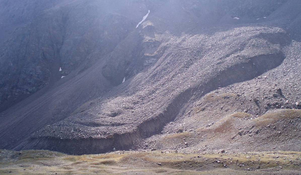
The proportion of ice in the ice concrete layer is a determining factor in geomorphological dynamics. If this concrete is saturated or supersaturated with ice, permafrost is likely to flow by creep on the slopes, which allows it to be found at lower altitudes, particularly in forms called rock glaciers, which are very numerous in the French Alps, from Mercantour to Vanoise.
The presence or absence of rock glaciers, their morphology and functioning depend on the variable balance between the supply of rock debris and ice, which in turn are conditioned at the regional level by the climatic and geological context and, at a more local level, by the topo-climatic and geomorphological context [3].
The diversity of situations observed shows that most of the rock glaciers have a periglacial origin (i.e., the ice comes from burying snow under debris and freezing deep water), which does not exclude the presence of glacial ice (formed initially at the surface by the compaction of a neve). Finally, it should be noted that, regardless of the origin of the ice, only permafrost thermal conditions will allow the development and maintenance of a rocky glacier.

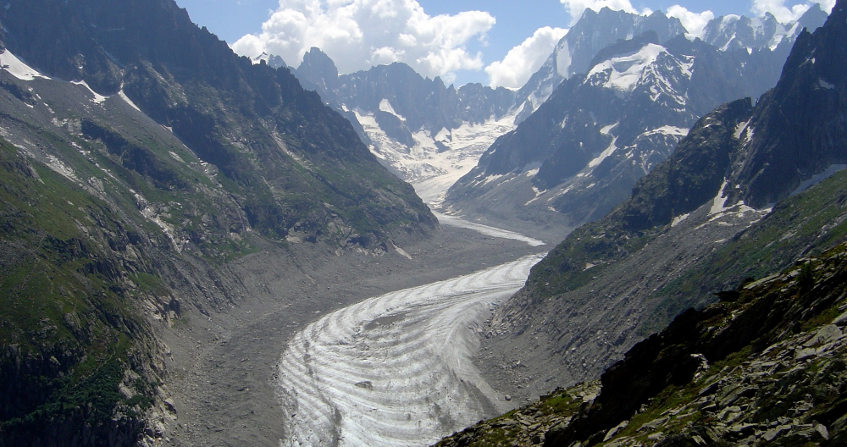
Rock glaciers, developed at varying rates depending on Quaternary climates, flow on the slopes and fill the high valleys, displacing considerable masses of material. Like glaciers, which are made up entirely of ice, rocky glaciers are subject to the vagaries of the climate in the medium and long term and leave obvious traces in the landscape. While glacial moraines are small in size, often dismantled by glacial meltwater, rocky glaciers remain in place and now spread their tongues up to 1500 metres above sea level in the Alps. However, only the highest of them, and therefore the most recent, still contain ice and may be in motion. It is generally accepted that the “activity” limit altitude of these rock glaciers (between 2500 and 3000 metres in the Alps) roughly corresponds to the lower limit of the discontinuous permafrost. A possible permafrost found at a lower altitude will be described as “sporadic” or in “isolated spots”. It can only correspond to very specific morphological and thermal situations, for example those linked to cold drafts in porous or karstified systems [4] : “cold scree”, “ice boxes” identified for example in the pre-Alpine mountains of the Chartreuse and Vercors.
Just as glaciers are retreating, alpine permafrost is responding to climate change that has been underway for several decades. First, its temperature rises to and approaches 0°C in many alpine sites. At the same time, the active layer, this surface portion that thaws in summer, thickens and the rheology of the frozen levels in the ground changes significantly. In the end, the lower limits of the alpine permafrost are expected to gradually increase in altitude.
It is the evolution of this margin (roughly located between 2300 and 3200 metres above sea level in our latitudes), which is out of balance with the climate, that raises major questions in terms of hazards and associated risks. Indeed, the degradation of permafrost could play a significant role in the upsurge of gravity, periglacial and torrential phenomena, due to the loss of the cohesive role of ice in stabilizing the upper slopes.
The consequences of permafrost warming that could affect our territories are of four kinds:
- the subsidence of detrital deposits, linked to ice melt, has already affected some ski resorts and high altitude installations in Switzerland and France [5];
- the destabilisation of frozen detrital deposits located on marked slopes would initially result in a significant acceleration of internal deformations (many known cases in the Alps), then in a rupture likely to mobilise the entire deposit (probable case of the rock glacier of Le Bérard in Ubaye [6]);
- the increase in the frequency of different gravity processes affecting high-altitude rock walls; the melting of the ice contained in the wall joints is probably the cause of the recent collapses at the Brenva Spur and Drus [7];
- the increase in the frequency of torrential lava and mud flows, either by deepening the active layer of permafrost (case of Ritigraben, Valais, Swiss Alps [8], and the rock glacier of the Col du Lou in Lanslevillard, Savoie) or by increasing sedimentary inputs from the walls, which can therefore be mobilized during major rain events (case of the Armancette torrent, Haute-Savoie).
References and notes
Cover photo: Permafrost thaw ponds on peat bogs in Hudson Bay, Canada in 2008. [Source: Steve Jurvetson[CC BY 2.0], via Wikimedia Commons ]
[1] Müller S.W. (1947) Permafrost and permanently frozen ground and related engineering problems. J.W. Edwards ed., 231 p.
[2] Bodin X., Lhotellier R., Schoeneich P., Gruber S., Deline P., Ravanel L. & Monnier S. (2008) Towards a first assessment of the permafrost distribution in the French Alps. Swiss Geoscience Meeting, 21-23 November 2008, Lugano
[3] Local terrain and slope exposure conditions
[4] with open cracks and dissolution cavities, as can be found in limestone rocks
[5] Fabre D., Cadet H., Lorier L. & Leroux O. (2014) Detection of permafrost and foundation related problems in high mountain ski resorts. IAEG Congress Torino, in Lollino et al, Springer, vol 1, paper 60, 321-324
[6] Schoeneich P., Bodin X., Echelard T., Kaufmann V., Kellerer-Pirklbauer A., Krysiecki J.-M. & Lieb G.K. (2014) Velocity changes of rock glaciers and induced hazards. in Lollino G., Manconi A., Clague J., Shan W., Chiarle M. (eds): Engineering Geology for Society and Territory – Volume 1, Springer, pp. 223-227. DOI: 10.1007/978-3-3-319-09300-0_42
[7] Ravanel L., Deline P. et al (2007) Ecroulement en haute montagne à permafrost : l’exemple du petit Dru (Massif du Mont-Blanc). Annual meeting of the Société Hydrotechnique de France (Nivologie-Glaciologie), Grenoble
[8] Rebetez M., Lugon R. et al (1997) Climatic changes and debris flows in high mountain regions: the case study of the Ritigraben Torrent (Swiss Alps) – Climatic Change 36, 371-389
The Encyclopedia of the Environment by the Association des Encyclopédies de l'Environnement et de l'Énergie (www.a3e.fr), contractually linked to the University of Grenoble Alpes and Grenoble INP, and sponsored by the French Academy of Sciences.
To cite this article: SCHOENEICH Philippe, FABRE Denis (January 5, 2025), The permafrost, Encyclopedia of the Environment, Accessed July 5, 2026 [online ISSN 2555-0950] url : https://www.encyclopedie-environnement.org/en/soil/permafrost/.
The articles in the Encyclopedia of the Environment are made available under the terms of the Creative Commons BY-NC-SA license, which authorizes reproduction subject to: citing the source, not making commercial use of them, sharing identical initial conditions, reproducing at each reuse or distribution the mention of this Creative Commons BY-NC-SA license.