


Overview of cloud classification
PDF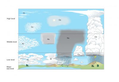
The main reference for cloud definitions and classification is the Cloud Atlas, published by the World Meteorological Organization. WMO is a specialized agency of the United Nations and currently has 193 Member States and territories. It is the authoritative authority on the state and evolution of the Earth’s atmosphere, its interaction with land and oceans, the weather and climate it generates and the resulting distribution of water resources. This Atlas presents with remarkable illustrations the cloud classification and naming system used by all WMO Members. It is based on a vocabulary that is both precise and specialized. At the root of this abundant vocabulary, two words seem indispensable:
- Meteor, used to designate any object or phenomenon that is not transparent and therefore observable in the atmosphere, such as a suspension or any form of precipitation,
- Hydrometeor, used to designate any object containing water, in a liquid or solid state, falling into the atmosphere.
In the classification established by the WMO, clouds are grouped into 10 genera, which in turn are subdivided into species and varieties. Let us limit ourselves here to the list of these 10 genera that are fairly easy to recognize in the atmosphere, which excludes those present beyond the troposphere: Altocumulus (Ac), Altostratus (As), Cirrus (Ci), Cirrocumulus (Cc), Cirrostratus (Cs), Cumulus (Cu), Cumulonimbus (Cb), Nimbostratus (Ns), Stratocumulus (Sc), Stratus (St). For each, the abbreviation in parentheses is the one shown in the Table.
Table. Approximate heights of each level, and the genera occurring in each.
| Level | Genera | Polar region | Temperate region | Tropical region |
| High | Cirrus Cirrocumulus Cirrostratus |
3 – 8 km (10 000 – 25 000 ft) |
5 – 13 km (16 500 – 45 000 ft) |
6 –18 km (20 000 – 60 000 ft) |
| Middle | Altocumulus Altostratus Nimbostratus |
2 – 4km (6 500 – 13 000 ft) |
2 – 7 km (6 500 – 23 000 ft) |
2 – 8 km (6 500 – 25 000 ft) |
| Low | Stratus Stratocumulus Cumulus Cumulonimbus |
From the Earth’s surface to 2 km (0 – 6 500ft) |
From the Earth’s surface to 2 km (0 – 6 500ft) |
From the Earth’s surface to 2 km (0 – 6 500ft) |
Each type of cloud falls within a fairly well-defined range of altitudes, called a level, and does not emerge from it, although some may straddle two decks (see Figure 1). This is particularly the case for Cumulonimbus (Cb), which leads to the formation of thunderstorms and whose anvil-like structure can peak at altitudes close to 10 km, and Nimbostratus (Ns), which can produce abundant precipitation. Usually three stages are distinguished to locate their approximate altitudes, which vary quite significantly with latitude.