


The Messinian Salinity crisis and its consequences on karst
PDF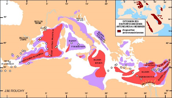
At the end of the Miocene, in Messinian (from -7.246 to -5.333 Million years ago), an event exceptional in its scale and short duration affected only the Mediterranean basin: the Messinian Salinity Crisis (CMS). The closure of the Strait between the Atlantic and the Mediterranean has caused the basin to gradually dry up, with significant gypsum-salt deposits [2]. The maximum reduction was 1500 to 2500 m below the current level, depending on the residual basins, for about 600,000 years. CMS has forced all flows, both surface and underground, to adapt to this very low baseline level. The rivers have dug deep valleys going up very far upstream, the Nile to Aswan or the Rhône to Lyon. In carbonate rocks, karst has developed to their base, sometimes several hundred metres below current sea level [3]. The opening of the Strait of Gibraltar, marking the beginning of the Pliocene, caused the almost instantaneous flooding of the entire basin, favouring a thick sedimentation fed by the rivers, consisting of blue marine clays of the Zanclaean, surmounted by the deltaic and alluvial formations of the Astien.
These sources are supposed to discharge considerable volumes of fresh water directly into the sea; they are also the subject of abstraction projects, such as those in Port Riou [6] or La Mortola [7]. The detailed study of certain sources [4] [5] [6] shows that the natural salinization of groundwater is inherent in the very functioning of these coastal karst aquifers and that the capture of these sources at sea can only facilitate marine intrusion. This is why it is preferable to seek to capture fresh water from boreholes on land, by monitoring the operation of these sources to provide an “alarm” in the event of overexploitation [8].
References and notes
[1] Dromart, G. (2005) http://planet-terre.ens-lyon.fr/article/paf-2005-variations-niveau-marin-dromart-conf.xml.
[2] Rouchy, J. M., Suc, J. P., Ferrandini, J., Ferrandini, M. (2006). The Messinian Salinity Crisis revisited. Sedimentary Geology, 188-189, 1-8.
[3] Arfib, B., de Marsily, G., Ganoulis, J. (2002). Coastal karst sources in the Mediterranean: study of the saline pollution mechanisms of the Almyros of Heraklion (Crete), observations and modelling. Bull. So. Geol. France, 173 (3), 245-253.
[4] Fleury, P., Bakalowicz, M., de Marsily, G. (2007). Submarine springs and coastal karst aquifers: a review. J. Hydrology, 339, 79-92.
[5] Fleury, P. (2005). Mediterranean underwater springs and coastal aquifers. Operation and characterization. PhD thesis, Earth Sciences, University of Paris-6.
[6] Cavalera, T. (2007). Study of the functioning and supply basin of the underwater spring of Port Miou (Cassis, Bouches-du-Rhône): Multi-criteria approach. PhD thesis. University of Provence, Marseille.
[7] Fleury, P., Bakalowicz, M., Becker P. (2007). Characterization of a karst system with an underwater outlet, example of the Mortola (Italy). Geoscience reports, 339, 407-417.
[8] Bakalowicz, M. (2015). Karst and karst groundwater resources in the Mediterranean. Environmental Earth Sciences, 74, 5-14.