The impact of climate change on snow cover and Alpine glaciers: consequences on water resources
PDF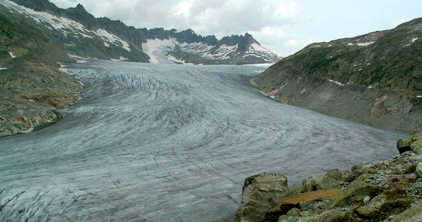
The Alpine Rhône illustrates how global warming could influence river flow, not only through changes in precipitation patterns but also through the effect on snow and glaciers, essential elements of the hydrological cycle in mountain regions such as the Alps. Projections of future climates, based on simulations by regional climate models, suggest an increase in winter precipitation, a sharp decrease in summer rainfall, a significantly reduced volume of snow, and a sharp decline in most alpine glaciers. As a result, by the end of the 21st century, flows are expected to be strongly influenced by these changes, with an increase in winter flows due to early snowmelt and increased precipitation, but a reduction in flows during the rest of the year. Seasonal changes imposed by a warmer climate will require a transformation of current water governance to allow for equitable sharing for the economic sectors concerned.
1. The Swiss Alps, Europe’s water tower
Many of the rivers that supply Western and Central Europe originate in the Alps. The Alps in general and Switzerland in particular have often, and rightly, been called Europe’s water tower. And for good reason, Switzerland receives an average of nearly 1500 mm of precipitation per year: one third is lost through evaporation when nearly two thirds feed streams and rivers on the surface. A small fraction is temporarily stored in lakes or groundwater.
According to the Swiss Climatological Atlas [1], the Central Swiss Alps region within a radius of 30 km around the Gotthard Pass alone irrigates four major basins. It supplies the North Sea through the Rhine basin (this basin accounts for about two thirds of all water exported by Switzerland). It supplies the Mediterranean through the Rhône basin (18% of Switzerland’s water exports). It feeds the Adriatic through the Po basin (Ticino, a tributary of the Po in Italy, accounts for 10% of the flow from Switzerland). It finally feeds the Black Sea through the Inn which flows into the Danube in Germany, which represents 5% of the flows leaving Switzerland. More than 150 million people live in these different basins and depend on water originating in the central Alps.
2. The role of snow
Snow is an essential component of the mountain hydrological system. Any change in the quantity, duration and seasonality of snow cover can have lasting environmental and economic consequences [2]. The timing of snowmelt in the mountains strongly influences the seasonal peak of flows in an alpine river. The late melting that persists in the high mountains makes it possible to maintain a minimum flow even during the hot and dry periods of the year.
3. The effects of climate
According to climate predictions, warmer winter conditions combined with higher precipitation in the Alps will contribute to an increase in the amount of snow at high altitudes. As a corollary, they will result in a significant decrease in snow cover in low- and mid-altitude regions, where precipitation will tend to fall as rain. There could also be more rain-on-snow events, including in mid-winter. This could result in flash floods [5].
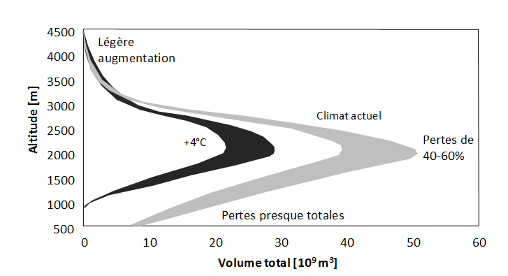
According to many climate models, if winter minimum temperatures were to increase by 4°C, it is estimated that snow cover would decrease by more than 100 days in the altitude range between 1500 and 2500 m asl. The increase in winter precipitation would therefore only slightly offset the effect of temperature on snow cover. At low elevations, increased temperatures would result in almost no snow during most winters, while changes at very high elevations would be minimal.
4. What are the impacts on glaciers?
The volume of a glacier, which is reflected in its surface and thickness, is determined by the balance between snow accumulation and glacier melt. If the climate changes, this balance will change. This will disrupt the altitude of the glacier’s equilibrium line, the altitude at which accumulation and ablation are in equilibrium. This will result in a change in thickness and the advance or retreat of the glacier. Most alpine glaciers except those at very high altitudes (above 3500-4000 m) have surface and internal temperatures very close to the freezing point. Therefore, any increase in temperature above this 0°C threshold can lead to a very pronounced glacier response.
Between 1850 and 2000, the glaciers of the European Alps lost between 30 and 40% of their surface area and about half of their volume [1]. A similar finding has been made on many mountain glaciers around the world, both in mid-latitudes and in the tropics.
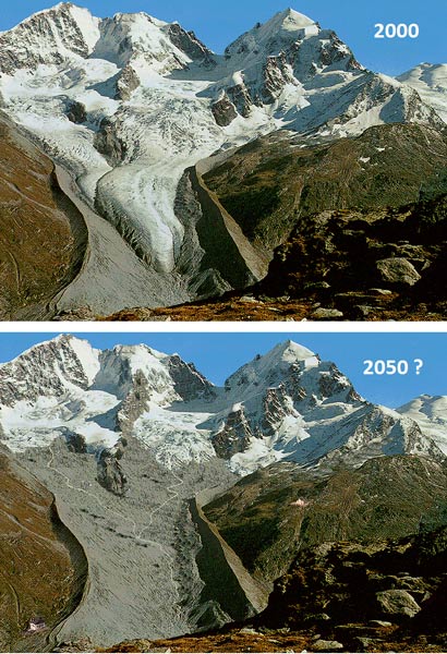
Assuming a warming of +3°C by the second half of the 21st century, Maisch [10] calculated for several glaciers in the Swiss Alps the future altitude of the equilibrium line (i.e. the transition level between the ablation and accumulation zones of the ice). Using computer-generated images and Geographic Information Systems (GIS) techniques, he was able to highlight the future morphology of the glaciers, their volume, and the position of their frontal tongue, as in the case of the Tshierva glacier (Bernina massif) in south-eastern Switzerland (Figure 3).
5. What are the consequences on the flow rates of the Alpine Rhône?
For a river like the Rhone, flows and their interannual variability are influenced by evaporation, precipitation, storage of water in artificial reservoirs and melting snow and ice. Precipitation throughout the year, as well as snow and ice melting areas between May and October, contribute mainly to flows in the alpine part of the Rhône basin [11] [12] [13]. In addition, the use of hydropower modulates flows in the Rhône in certain seasons and sometimes significantly: water is retained, especially during summer and autumn during snowmelt and summer melting of glaciers, and released to produce electricity, especially during winter when energy demand is at its highest. However, this water retained by dams represents only a small fraction of the total quantities of water at stake in the Rhône basin
The snowpack in the mountains is a much larger water supply. It is retained between November and May, while evaporation reaches its maximum during the summer months. Since, in the current climate, precipitation is relatively well distributed throughout the year, it is the melting of the snowpack that has the greatest influence on flows during the year. This surface runoff in late spring and part of summer is a function of the amount of snow accumulated in the mountains during the previous winter.
Whatever the nature of the change in the hydrological characteristics of many rivers with their source in the Swiss Alps, changes in mountain climate patterns will have an impact on the regions with low altitude populations. These depend on water resources from the Alps for their domestic, agricultural, energy and industrial uses. For example, according to various studies mentioned above, the Rhône, at its alpine outlet in Lake Geneva, could see its winter flows increase from 100 m3/s in the reference climate (1961-1990 period) to 200 m3/s by 2100, but decrease from 350 to 200 m3/s in the middle of summer (see Figure 4).
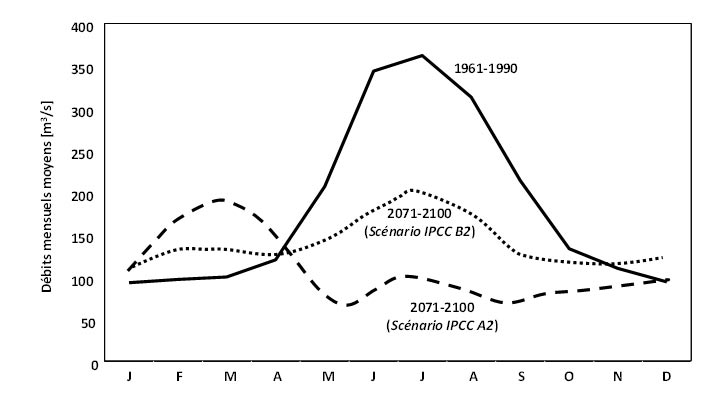
This figure shows that, for the 1961-1990 reference period, the flow of the Rhône is strongly influenced by the melting of the snowpack between spring and mid-summer, whereas after this melting and during the generally hottest and driest period of summer (between mid-July and early September), it is the flows linked to the summer melting of glaciers that continue to provide significant quantities of water in the Rhône.
What about flow forecasts according to climate change? By the end of the 21st century, profound changes are expected in the flows of the alpine part of the Rhône. Indeed, climate model projections [14] suggest that the central Alps will experience atmospheric warming in all seasons, but a seasonal shift in precipitation patterns, with a 10-20% increase in winter precipitation and a 10-40% decrease in summer rainfall [9].
Since glaciers are likely to have almost completely disappeared by the end of the century [1], there will no longer be this essential water supply which, in the current climate, serves to avoid severe low water levels. In a situation of high heat waves and significant water deficits, as in 2003, it is even possible that a river like the Rhône may dry up during part of the summer and autumn. For, unlike what happened in 2003 in Western and Central Europe, where an accelerated melting of glaciers has maintained a good flow in the Rhône despite the heat and drought, the glaciers would no longer be there to provide this relay. The future hydrological characteristics illustrated in Figure 4 are not unlike those already observed in the Mediterranean parts of the Alps, such as the Provençal Alps or the Italian slopes of the Alpine massifs.
Under the selected greenhouse gas emission scenario, maximum flows could occur two to three months earlier in the year due to earlier melting of the snowpack, while the maximum amount of water would be reduced because the total volume of the snowpack would be severely restricted by 2100. Despite the sharp decrease in flows during the summer (around 50 to 75% compared to the 1961-1990 reference curve), Figure 4 shows a slight peak in flow in mid-summer. This is due to convective rains that would appear from time to time despite the likely decrease in global summer precipitation. But we also note [15] [16] that even with some heavy rainfall in summer, the hydrological regimes of the Rhône will be much weaker than at present because of the virtual disappearance of alpine glaciers, as well as earlier snowmelt.
6. What are the environmental and economic impacts?
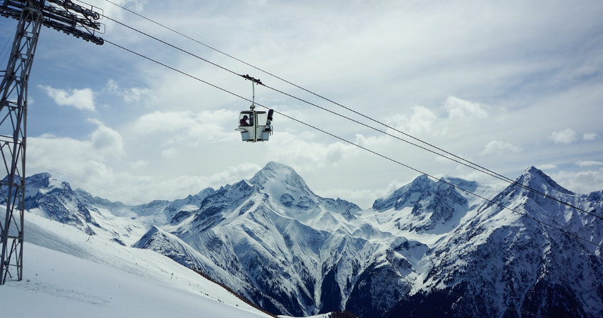
- The multiplication of winters with little snow will cause economic problems for low- and mid-altitude resorts (up to around 1,200-1,800 metres above sea level). A diversification of the tourist offer beyond the ski industry will be necessary for most alpine mountain resorts.
- In areas where agricultural irrigation is practiced (e.g. in the Rhône Plain of the Canton of Valais in Switzerland, and in the South of France), the demand for water could exceed the resources during very hot and dry summers. In addition, mountain farming is increasingly under pressure due to agricultural production at more competitive prices in lowland regions. It is likely to cause serious damage if, in addition to these economic pressures, extreme events such as droughts or floods were to increase. New regulations on the allocation of water resources to different users, the installation of new reservoirs, and technical improvements will have to be put in place.
- The large Alpine dams will be affected by the expected strong retreat of glaciers from the second half of the 21st century, as meltwater no longer fills the reservoirs as much as it does now. As a result, storage capacities could be reduced, resulting in a decrease in hydroelectric production. This will make it difficult to meet electricity demand, which will gradually shift from winter (peak energy demand) to summer due to air conditioning requirements. This will require optimal water management in the interconnected network of large dams, as well as economic mechanisms to influence supply and demand. This could challenge various strategies, both Swiss and European, to reduce dependence on fossil fuels in order to accelerate the implementation of the Paris Climate Agreement (COP21), signed in December 2015 and since then ratified by many countries. This would also affect the electricity grid not only in the Alps, where the problem originates, but also throughout Europe.
Finally, in terms of natural hazards in the Alps, the cumulative effect of heavy rainfall in low- and mid-altitude regions would lead to high rates of slope erosion. The expected increase in extreme precipitation is expected to lead to an increase in flood frequency and severity [25]. When these events occur in late summer, when soils are dry and have difficulty absorbing large and sudden amounts of surface water, many watersheds respond by overflowing. At other times of the year, flooding potential may also increase when precipitation, combined with snowmelt during winter and early spring, releases unusual amounts of water. This kind of situation has prevailed in the recent past, for example in February 1995 when the early melting of the snowpack in the Alps, combined with heavy rains in Germany, led to flooding along the Rhine route.
References and notes
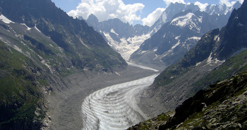
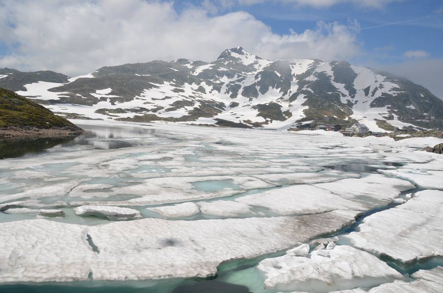
Cover image. The Rhone glacier [Source: Beniston]
Note: this text is based on extensive extracts from Chapter 8 of Martin Beniston’s book (“Climate Change and Impacts: From Global to Local”, 2012), reproduced with the kind permission of Presses Polytechniques et Universitaires Romandes in Lausanne, Switzerland
[1] Swiss Climate Atlas (2015). http://www.hydrologischeratlas.ch/fr
[2] Dedieu JP, Lessard-Fontaine A, Ravazzani G, Cremonese E, Shalpykova G, Beniston M. (2013). Shifting mountain snow patterns in a changing climate from remote sensing retrieval. Science of the Total Environment, 493, 1267-1279
[3] Haeberli, W., and Beniston, M. (1998). Climate change and its impacts on glaciers and permafrost in the Alps. Ambio, 27, 258 – 265
[4] Beniston, M., Keller, F., Koffi, B., and Goyette, S. (2003). Estimates of snow accumulation and volume in the Swiss Alps under changing climatic conditions. Theoretical and Applied Climatology, 76, 125-140
[5] Beniston, M., and Stoffel, M. (2016). Rain-on-snow events, floods and climate change in the Alps: Events may increase for warming up to 4°C and decrease thereafter. Science of the Total Environment, 571, 228-236
[6] Jouvet, G., Picasso, M., Rappaz, J., Huss, M., and Funk, M. (2011). Modelling and numerical simulation of the dynamics of glaciers including local damage effects. Mathematical Modeling of Naural Phenomena, 6, 263-280.
[7] Bonanno R, Ronchi C, Cagnazzi B, Provenzale A. (2014). Glacier response to climate change in northwestern Italian Alps. Regional Environmental Change, 14, 633-643.
[8] Six D. and Vincent C. (2014). Sensitivity of mass balance and equilibrium line elevation to climate change in the French Alps. Journal of Glacioogy, 60, 223
[9] Gabbi, J., Carenzo, M., Pellicciotti, F., Bauder, A., and Funk, M. (2014). A comparison of empirical and physically-basedglacier surface melt models for long-term simulations of glacier response. Journal of Glaciology, 60, 1140-1154
[10] Maisch, M. (1992). Die Gletcher Graubündens – Rekonstruktion und Auswertung der Gletscher und deren Veränderungen seit dem Hochstand von 1850 im Gebiet der östlichen Schweizer Alpen (Bündnerland und angrenzende Regionen). Publication Series of the Department of Geography of the University of Zurich, Switzerland
[11] Beniston, M. (2012a) Impacts of climatic change on water and associated economic activities in the Swiss Alps. Journal of Hydrology, 412-413, 291-296
[12] Uhlmann B, Jordan F, Beniston M. (2012a). Modelling runoff in a Swiss glacierized catchment – Part I: methodology and application in the Findelen basin under a long-lasting stable climate. International Journal of Climatology, 33, 1293-1300.
[13] Rahman K, Maringanti C, Beniston M, Widmer F, Abbaspour K, Lehmann A. (2013). Streamflow modeling in a highly managed mountainous glacier watershed using SWAT: the upper Rhone River watershed case in Switzerland. Water Resources Management, DOI: 10.1007/s11269-012-012-0188-9.
[14] Gobiet, A., Kotlarski, S., Beniston, M., Heinrich, G., Rajczak, J., and Stoffel, M. (2014). 21st century climate change in the European Alps: A Review. Science of the Total Environment, DOI: 10.1016/d.scitotenv.2013.07.050
[15] Beniston, M. (2012). Is snow in the Alps receding or disappearing? WIRES Climate Change (Wiley Interdisciplinary Reviews / Climate Change), DOI: 10.1002/wcc.179.
[16] Uhlmann B, Jordan F, Beniston M. (2012b). Modelling runoff in a Swiss glacierized catchment – Part II: daily discharge and glacier evolution in the Findelen basin in a progressively warmer climate. International Journal of Climatology, 33, 1301-1307.
[17] Hill Clarvis, M., Fatichi, S., Allan, A.A., Fuhrer, J., Stoffel, M., Romerio, F., Gaudard, L., Burlando, P., Beniston, M., Xoplaki, E., and Toreti, A. (2014). Governing and managing water resources under changing hydro-climatic contexts: The case of the Upper Rhone Basin. Environmental Science and Policy, DOI: 10.1016/day approx. 2013.11.005
[18] Quevauviller P, Barcelo D, Beniston M, Djordjevic S, Froebrich J, Harding RJ, Ludwig R, Navarra A, Ortega AN, Roson R, Sempere D, Stoffel M, van Lanen H, Werner M. (2012). Integration of research advances in modelling and monitoring in support of WFD river basin management planning in the context of climate change. Science of the Total Environment, 440, 167-177.
[19] Beniston, M., and Stoffel, M. (2014). Assessing the impacts of climatic change on mountain water resources. Science of the Total Environment, DOI: 10.1016/d.scitotenv.2013.11.122
[20] Finger D, Heinrich G, Gobiet A, Bauder A. (2012). Projections of future water resources and their uncertainty in a glacierized catchment in the Swiss Alps and the subsequent effects on hydropower production during the 21st century, Water Resources Research, 48, W03
[21] Gaudard L, Romerio F, Dalla Valle F, Gorret R, Maran S, Ravazzani G, Stoffel M, Volonterio M (2014). Climate Change Impacts on Hydropower in the Swiss and Italian Alps. Science of the Total Environment, 493, 1211-1221.
[22] Beguería S., López Moreno J.I., Gómez Villar A., Rubio V., Lana-Renault N. y García Ruiz J.M. (2006). Fluvial adjustment to soil erosion and plant cover changes in the Central Spanish Pyrenees. Geografisker Annaler, 88A, 177-186
[23] Stoffel M, and Wilford DJ. (2012). Hydrogeomorphic processes and vegetation: Disturbance, process histories, dependencies and interactions. Earth Surface Processes and Landforms, 37, 9-22.
[24] Wolf A. (2011). Estimating the potential impact of vegetation on the water cycle requires accurate soil water parameter estimation. Ecological Modelling, 222, 2595-2605
[25] Beniston, M., and Stoffel, M. (2016). Rain-on-snow events, floods and climate change in the Alps: Events may increase for warming up to 4°C and decrease thereafter. Science of the Total Environment, 571, 228-23
The Encyclopedia of the Environment by the Association des Encyclopédies de l'Environnement et de l'Énergie (www.a3e.fr), contractually linked to the University of Grenoble Alpes and Grenoble INP, and sponsored by the French Academy of Sciences.
To cite this article: BENISTON Martin (January 5, 2025), The impact of climate change on snow cover and Alpine glaciers: consequences on water resources, Encyclopedia of the Environment, Accessed July 30, 2026 [online ISSN 2555-0950] url : https://www.encyclopedie-environnement.org/en/water/impact-of-climate-change-on-snow-cover-and-alpine-glaciers-consequences-on-water-resources-2/.
The articles in the Encyclopedia of the Environment are made available under the terms of the Creative Commons BY-NC-SA license, which authorizes reproduction subject to: citing the source, not making commercial use of them, sharing identical initial conditions, reproducing at each reuse or distribution the mention of this Creative Commons BY-NC-SA license.