Karst, a renewable water resource in limestone rocks
PDF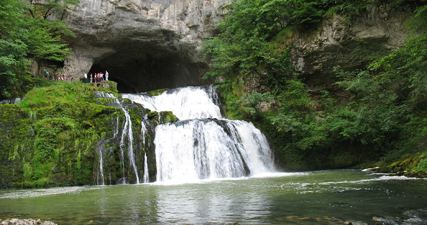
Studied in the 19th century for its hydrology and particular forms, the Karst region of Slovenia is considered the world reference for landscapes and underground flows in carbonate, limestone and dolomite rocks. Karst is defined as any region of the world where these rocks have an essentially underground hydrography, consisting of cavities that can be penetrated by man. These pipes lead to often spectacular springs used since ancient times for water supply. Karst and the processes of its genesis and evolution are aquifers with interesting resources and reserves to exploit. Its hydrogeological characteristics and functioning make it possible to understand its specificities in order to take better advantage of them without overexploiting its resources.
1. Karst, an important but complex geological medium
Well known and described as a landscape, karst is a geological formation established in carbonate, limestone and dolomite rocks. It is first and foremost an aquifer, a formation in which groundwater accumulates, circulates and emerges at often important sources. It is often a remarkable and very special groundwater reservoir.
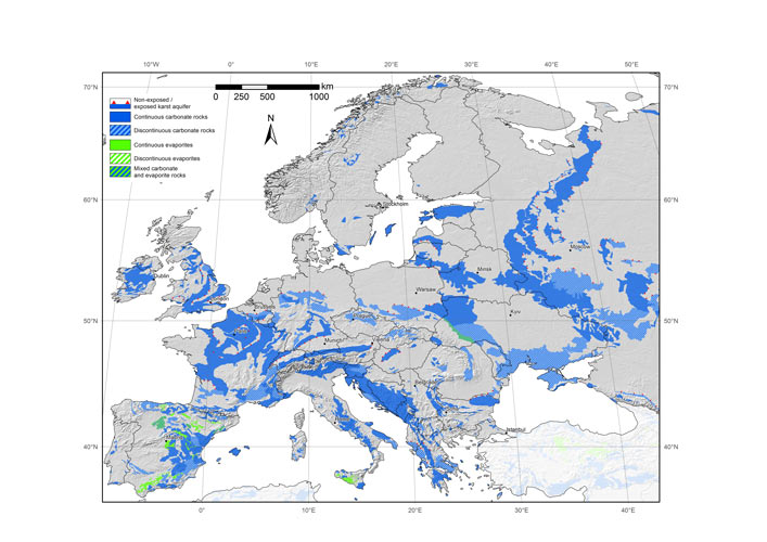
On a global scale, these karst formations cover 12 to 15% of the continental surface. In France, they occupy 35% of the territory’s surface area, which should make them play a major role in terms of water resources; the extension of carbonate rocks under other geological formations leads us to consider that these karst aquifers are even more extensive. Thus, according to the most recent estimate (Figure 1), nearly 50% of the territory is affected by karst formations. Karst aquifers contribute 40% of the total drinking water supply (DWF) of the French. It is estimated that about ,25% of the world’s population is supplied with domestic water from groundwater extracted from the karst [1].
In most aquifers, water circulates and accumulates in the original voids of the rock: the pores or discontinuities produced by the deformations. Karst aquifers are distinguished from them by the fact that the water that flows through these original voids deeply modifies some of them to the point of creating conduits and cavities that are sometimes penetrable by humans. This transformation takes place in a short period of time on a geological scale: a few thousand to a few tens of thousands of years. More than an aquifer, the karst is therefore a geosystem.
Its economic interest is not limited to the consumption of drinking water; it is also used for irrigation and industry. It is also associated with a large number of thermo-mineral springs. In addition, karst is frequently the site of oil deposits, including those on the Arabian platform. It may also contain metal deposits: aluminium (bauxite), iron, lead and zinc ores. Finally, it regularly poses problems during civil engineering works, including dams and their reservoirs.
This article limits itself to showing what karst is, how it is set up, what are the characteristics of the structure and functioning of the aquifers it forms, and finally how it can be managed.
2. A very specific landscape
Karst consists of surface and underground forms resulting from the dissolution of carbonate rocks (limestone, dolomite) by water made acidic by carbon dioxide in the soil air. The voids thus created allow the flow and storage of groundwater. This set of processes that transform a simple limestone or dolomitic formation into a karst massif with dolines, chasms, caves, underground river and well individualized spring is called karstification (read Focus 1: Mechanisms of karstification).
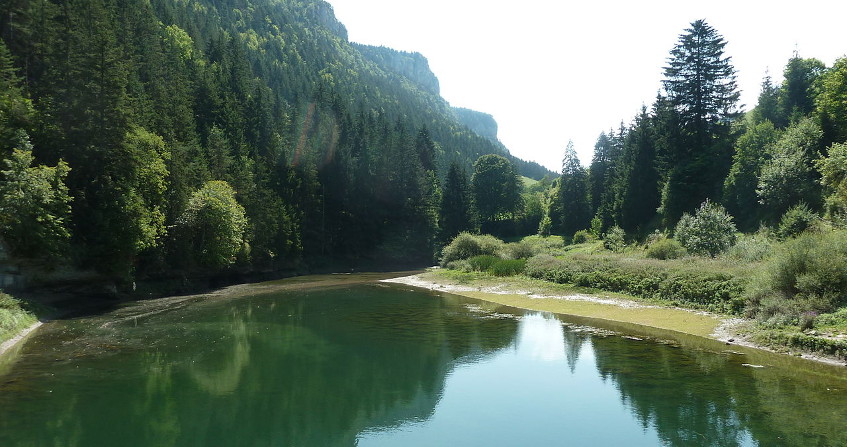
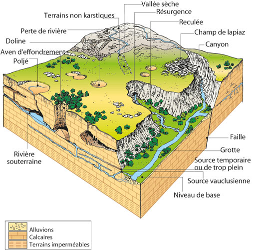
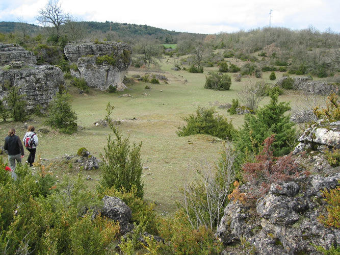
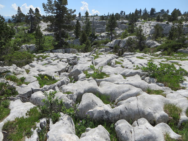
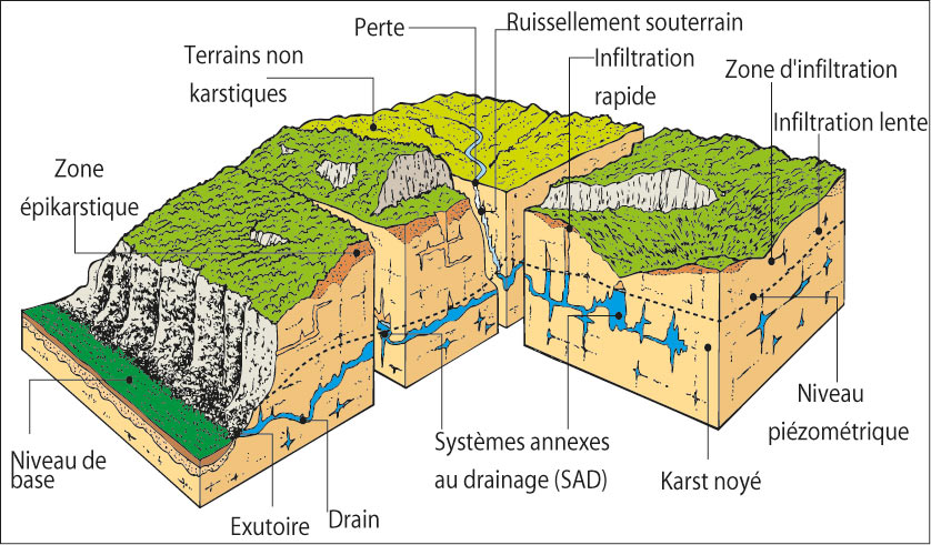
As shown in the diagram in Figure 2 and in the photo and Figure 3, the karst landscape is marked on the surface by closed depressions, ranging from a few metres to several kilometres, generally marked by areas favourable to rapid water absorption. The smaller of these depressions, called dolines (Figure 4), sometimes open into a cave, a chasm (or cave) that quickly absorbs rainwater. The largest of these depressions, the poljés, receive large volumes of water from rivers flowing over impermeable terrain. Losses, or ponors, absorb these watercourses into the limestone and feed the springs. Downstream of the losses, the valleys are dry most of the time; their bottoms are marked by closed depressions, inherited from former losses.

When the rock is bare, the initial fractures appear more or less widened, creating waves, peaks, corridors or simply more or less deep grooves: it is the lapiaz, which retains the soil and sediments provided by runoff, precipitation and winds. When such a sedimentary cover settles permanently, the lapiaz evolves into more rounded shapes due to the effect of a better distributed dissolution.
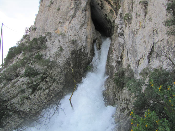
The karst are also spectacular sources, such as the Fontaine de Vaucluse or the source of the Loiret. This water concentration in the valleys contrasts with the apparent dryness of the karst massifs. The karst system is the set of water catchment areas of a karst spring, formed by surface runoff feeding losses and all calcareous outcrops where precipitation water infiltrates. The position of the source is determined by the base level of the system, the lowest point of the limestone formation at the outcrop. It can be the contact with the impermeable formation under the limestones; it is most often the bottom of river valleys of regional importance.
3. The result of a long geological and climatic history
Once the pipes have been created to drain groundwater to the source, the karst system is subject to changes in climatic and geological conditions, as are all hydrosystems. The geological history of the continents is marked by permanent changes in regional baselines. This may be related to a change in sea level (for example, during the Quaternary ice ages, the global ocean was 120 m below current levels), or to movements imposed by plate tectonics, such as subsidence and over-reaction that cause mountain ranges and basins to form. These variations modify external conditions by increasing or decreasing the ability of underground flows to create a network of conduits, known as the Karstification Potential or KP (read Focus 1:The mechanisms of karstification).
The over-reaction produces a lowering of the base level and an increase in the KP which allows the creation of a new network of pipes, the old network being abandoned at least in part and incorporated into the infiltration zone: this is how caves that can be penetrated by man are created. The consequences are varied, depending on the geometry of the aquifer formation: capture of neighbouring karst systems, fragmentation into several systems, migration of the source to another valley, appearance of overflow sources, etc., leading to a more complex drainage and therefore to the functioning of the system.
Subsidence, on the other hand, causes a rise in the base level and a reduction in the KP, producing a flooding of the karst structure by blocking or even clogging. The former networks of pipes thus submerged (see figure 2) give the aquifer a high inertial behaviour [2] because they constitute storage structures of several hundred million m3.
In coastal areas, a marine transgression due to sea level rise has a different effect depending on whether or not it is accompanied by impermeable marine sediment deposits. In the first case, the situation is identical to that of sediment filling a basin. In the second case, in the absence of marine sedimentation, the networks of pipes leading to the sea allow exchanges with sea water. These exchanges are variable according to the hydraulic load (pressure) relationships between freshwater in the aquifer and seawater. Fresh water can escape from the aquifer when the hydraulic load is high. Seawater can enter the aquifer when the load is low.
Indeed, the difference in density between fresh water and seawater is the predominant factor in the respective movements of the two fluids. Due to the difference in density between fresh water (1.0) and salt water (1.025 on average), the fresh water column in the pipes must be sufficiently above sea level to push the salt water out of the pipes. The aquifer then discharges its fresh water into the sea. As soon as this charge decreases (no recharge or rising tide), sea water gradually enters the pipes from submerged karst forms and mixes with fresh water: the discharge at sea is that of brackish water, whose salinity increases with the decrease in the hydraulic charge in the aquifer. This mechanism also concerns coastal springs on land, whose water is brackish because of the natural intrusion of salt water into the pipes; this is the case of the Fontestramar spring in Roussillon [3]. This natural intrusion of seawater is obviously aggravated by water withdrawals by pumping, from boreholes on land, even if they are far away [4].
The global ocean was subjected to slow and limited sea level variations; during the last glaciation, it descended and then rose by about 120 m. But the Mediterranean basin has been subjected to a particular geological event, the Messinian Salinity Crisis, which, by its scale, is at the origin of the great concentration of underwater sources of karst origin (Read Focus 2: The Messinian Salinity Crisis and its consequences on the karst).
4. Above all an aquifer
The karst is therefore first and foremost an aquifer hydrological system, and not just a landscape. Shaped according to subterranean flows, with closed depressions and abysses, places of preferential absorption, the surface landscape may have remains of a fluvial organization of past flows, such as dry valleys and alluvial veneers. This organization is gradually being dismantled in favour of underground traffic in fractures and conduits of varying sizes.
Compared to other aquifers, karst has the following specificities:
- A network of conduits that leads to sources. Water flows create and modify voids permanently, which results in their organization into a drainage network, feeding often spectacular springs (Fontaine de Vaucluse, source of the Lez, source of the Loiret, etc.).
- Sources with very variable flow rates (see Figure 5). Depending on the season, the natural flow of the source of the Lez River, for example, varies from a few hundred litres per second in low water to 30 m3/s in high water [5].
- Stoned galleries accessible to man. The dimensions and shape of these voids change over time, to the point that they are partly penetrable. Caves (e.g. Armand cave, Padirac abyss, Clamouse caves, des Demoiselles, de la Cocalière) are old networks abandoned, at least in part, by underground flows.
- Complex underground circulations. The karst aquifer is characterized by considerable heterogeneity, both in terms of the size of its voids (from a few micrometers to several kilometres in length) and in terms of water flow rates (from a few tens of m per year to a few km per hour).
The karst aquifer is therefore much more complex than porous or fractured aquifers, both in the infiltration zone and in the flooded zone.
4.1. A privileged area of infiltration

From the dolines, more or less wide vertical ducts develop, such as chasms and avens, crossing the infiltration zone forming a “doline – well” system (Figure 3). Between these axes draining water directly and rapidly into the flooded area, the cracks in the rock are more or less widened by a simple mechanical relaxing effect, especially on the slopes of the valleys, then by the action of the tree roots, reinforced by the dissolution. This is the lapiaz domain (Figures 7 and 8).
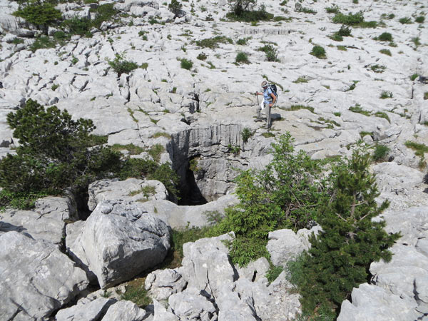
The permeability of this near-surface area is then increased compared to that of the deeper rock. As a result, the infiltration water is locally retained and constitutes a saturated zone at shallow depth, i.e. an area where all voids are filled and traversed exclusively by water, while above it a mixture of air and water circulates. This area is discontinuous because it is laterally drained by the doline – well system. It is also extracted by slow infiltration into the cracks in the rock, feeding underground concretions, including those in caves.
This “perched saturated zone” provides water for the evapotranspiration of the often abundant vegetation cover, which can withstand a prolonged dry season. This aquifer is called epikarstic [6]. It was once used, as evidenced by the capture of small springs and abandoned tank wells. It is a link between surface and underground communities: animals, such as microcrustaceans, beetles and more generally soil fauna, living on the surface colonize and gradually adapt to the underground environment [7]; it is also where underground populations find their food in abundance. The maintenance of vegetation and soil cover and therefore biological diversity also depend heavily on these epikarst aquifers. The “lapiaz – doline – perched aquifer” ensemble constitutes the epikarst.
The infiltration zone of the karst [5] is therefore subject to several flow modalities:
- delayed infiltration by storage near the surface in the epikarst, where the water is subjected to biogeochemical processes in the soil (concentration by evapotranspiration of dissolved salts from precipitation, exchanges of dissolved elements with the clay-humic complex, CO2 production);
- direct, rapid infiltration by the doline system – wells and the most widely open fractures, real underground runoff, responsible for the dissolution of the rock at depth;
- a slow, two-phase infiltration, i.e. a mixture of air and water that travels through the fine cracks and porosity of the rock. It dissolves the carbonate rock near the surface and is responsible for transporting dissolved and gaseous CO2 throughout the infiltration zone;
- concentrated and rapid infiltration, fed by rivers flowing over non-karst terrain, lost in contact with limestone (Figure 2).
These different infiltration modalities contribute to the recharge of the saturated zone, or drowned karst, in variable proportions in space and time.
4.2. A drowned area organized around drainage and storage
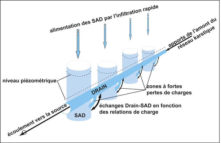
The drowned karst has a very high heterogeneity of permeability, with permeability coefficients [8] ranging from 10-7 to 10-1 m/s. This heterogeneity is not randomly distributed. It is organised around ducts (see Figures 4 and 5), axes with very high permeability, in a hierarchical network, in the same way as river networks. Water flows between these drains and their environment where water flows less quickly and is stored. These are areas of lower permeability, consisting of pores and cracks in the rock, in what is called a “matrix” or “matrix blocks”. They are also large karst voids, constituting elementary reservoirs, independent of each other. A. Mangin [9] referred to these reservoirs as Drainage Ancillary Systems (DAS).
As shown in Figure 9, DSS are cavities created in the flooded area at the base of the rapid infiltration axes. They are connected to the ducts by draining zones with high pressure drops due either to the complexity of the ducts or to the fact that only the original cracking ensures hydraulic continuity. This situation favours large amplitude piezometric variations in DSS and raster blocks, ranging from several tens to a few hundred metres between the flood and low water levels, while they are much lower in the pipes. Flows occur according to the respective load relationships, sometimes from the ducts to the DSS or raster blocks, sometimes in the opposite direction. Thus, the karst environment has two types of voids performing different hydrodynamic functions, drainage and storage, of which Margin [9] has proposed a schematic representation (Figure 10).
5. Groundwater exploitation in karst
It is around karst springs that some of the great ancient civilizations of the Mediterranean regions were created and developed. Large ancient cities in the Middle East, Greece, Rome and their colonies have developed through the exploitation of karst springs: sites such as Baalbek, Damascus, Tyre, Athens, Rome, Carthage or Nîmes have radiated through the collection of karst springs, aqueducts and urban distribution networks [10]. These run-of-river operations are limited by the low water flow. The increase in cities’ needs is then met by seeking new resources and carrying out new developments, such as in Rome or Lyon, where new water catchments and aqueducts have been built.
Karst waters were then used without taking into account the particular characteristics of karst and without any concern for water quality [11]. It was only at the end of the 19th century that the first speleologists in France and Austria showed the relationships between springs and certain abysses used as mass graves, establishing the link between these pollutions and certain epidemics (diphtheria, typhoid…). In France, strict regulations marginalized the exploitation and study of karst groundwater. They have pushed communities to prefer other groundwater and surface water to them.
The karst was then considered as a desolate landscape, consisting of a few large conduits at depth directly connecting the avens to the springs [12]. The Bramabiau underground river, which resulted from the rush of the waters of Happiness in the Causse de Camprieu, on the edge of the Cévennes, was even taken as a model of all the underground flows in the karst. For this reason, the Causses were considered in France as the reference in terms of karst and for a long time the qualification of karst emergencies as a source was refused.
5.1. An environment particularly sensitive to human activities
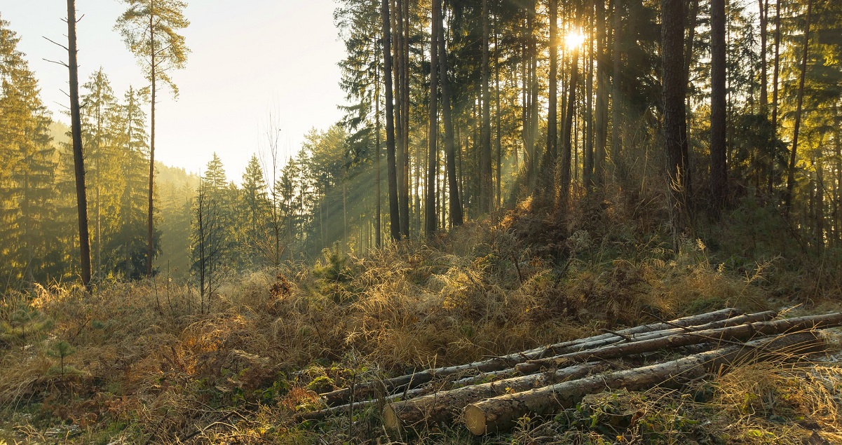
Soils, which are generally thin and discontinuous, are very sensitive to erosion. Deforestation, grazing or fires promote the erosion and destruction of lapiaz, whose disappearance then prevents vegetation from re-establishing itself. These bare and dry landscapes resulting from human actions do not allow the natural filtration of water.
In addition, large voids and high flow velocities are at the origin of the rapid transfer, without dilution or filtration of pollutants to the sources. The karst aquifer is therefore often considered to be unfavourable for drinking water abstraction for drinking water supply (WSP). It is also difficult to provide effective protection measures for karst EAF catchments. The main obstacle is the large size of source water basins requiring long and costly hydrogeological studies. The vulnerability of karst is logically deduced from a series of unfavourable characteristics, such as rapid flow rates, lack of filtration and self-purification, limited effects of dilution or dispersion.
But on the other hand, this vulnerability has some interesting characteristics such as:
- the generally rapid elimination of accidental pollution, in connection with the short residence times of groundwater,
- retarding effects (adsorption, dispersion) which are usually negligible,
- a rapid change in water quality at the scale of the hydrological cycle as a result of changes in chronic or seasonal pollution discharges,
- the main reasons for this are the long periods of low water levels during which the water is of good to excellent quality, due to its slow flow, as opposed to floods that can be subject to bacteriological and/or chemical contamination and frequent turbidity).
An approach and methodology have been proposed [13] for the establishment of catchment protection perimeters in karst regions. Multi-criteria analysis methods are now being applied to characterize the vulnerability of the captured sources. The main criteria considered are soil and epikarst, infiltration patterns and the degree of functionality of the drainage system. These methods propose a systematic analysis of the karst system, divided into small mesh sizes. Vulnerability maps are obtained after weighting and combining all these criteria.
The systematic water treatment imposed on karst EPAs generally avoids bacteriological risks. Chemical risks, such as excess nitrates, are reduced because they are rare in these areas with low anthropogenic pressure, or without cumulative pollution, by rapid elimination during floods. Turbidity [14], on the other hand, is a recurrent problem, particularly in Normandy, in chalk, or when the aquifer is massively fed by river losses. Settling and filtration systems are required. A temporary alternative resource or a catchment by a borehole located away from the karst conduit can be put in place while waiting for a return to normal.
5.2. Drinking water supplies in quantity
In Mediterranean countries, karst is often the only usable aquifer formation, although its waters are sometimes contaminated by natural intrusion of seawater or pollution. Finally, karst is most often the only and exclusive aquifer that feeds the rivers of these regions: it plays an essential role in many hydrosystems and must therefore be taken into account in the exploitation and protection of water resources.

Increasing needs and technological developments have led to the need to pump groundwater from the sources themselves (Figure 11), where possible, or through drilling [15]. But the heterogeneous distribution of voids in the aquifer means that the probability of a well reaching a cavity is extremely low. There is no geophysical method that would certainly locate a cavity more than 30 or 40 m below the surface [16], given their small relative dimensions (a few metres, exceptionally a few dozen metres). The magnetic locating method allows a conduit to be located below 300 to 400 m, provided that an operator can enter it with a fairly powerful transmitter. This is the method that has been used to position the drilling for the exploitation of the Lez spring in Montpellier [17]. In other cases, the relief is used to reach the area drowned by galleries, as has been done in the Swiss Jura [18].
In view of their complexity and diversity of organization and functioning and because of their often large extent, karst aquifers require detailed studies, based on a specific multidisciplinary methodology. Hydrogeologists now have the necessary tools to characterize their functioning, identify the most productive areas and properly evaluate their resources and reserves [19].
It is then possible to exploit in low water a flow higher than the natural flow, by taking from the aquifer reserves, which are replenished during recharge in the rainy season. Compared to the storage of surface water in artificial reservoirs, the advantage of exploiting karst groundwater is that it is not affected by evaporation and, above all, it is much less sensitive to pollution. But, as with an artificial tank, it is necessary to know how to evaluate the conditions of supply (refilling) and emptying (discharging). Thus, the source of the Lez, in Montpellier, was captured, following studies conducted by J.V. Avias and his team [18] [5]. This capture is considered a global model. Studies show that rigorous management, based on detailed knowledge and an appropriate network of measures, is sustainable and makes it possible to limit the effects of major floods downstream. Finally, the feasibility of artificially replenishing karst aquifers is now considered as part of a proactive management approach to karst aquifers [20],[21].
6. Prospects for water resource management
Karst systems can provide considerable groundwater resources and supplies, easily exploited from a single site, which can be a high flow source or well. But their aquifers are very sensitive to pollution, as they generally have little natural filtering protection and reduced dispersive effects. However, due to rapid flows and average residence times that are often less than one year, they renew much more quickly than porous and fractured aquifers: they retain little or no memory of events that have occurred in previous hydrological cycles, such as drought, temporary overexploitation or accidental or seasonal pollution. Finally, they can be artificially recharged by river water inflows.
Hydrogeologists and water resource managers now have an effective methodology to identify all their characteristics and models to manage them. Karst must be considered as a particularly interesting geological environment in water policy, often offering drinking water resources and reserves, drought inputs and flood control opportunities without major hydraulic works.
References and notes
Cover image. Source of Lison (Doubs) [Source: photo M. Bakalowicz]
[1] Chen, Z., Auler, A. S., A. S., Bakalowicz, M., Drew, D., et al. (2017). The World Karst Aquifer Mapping project: concept, mapping procedure and map of Europe. Hydrogeology J. , 25, 771-785.
[2] El Hakim, M., Bakalowicz, M. (2007). Significance and origin of very large regulating power of some karst aquifers in the Middle East. Involvement on karst aquifer classification. J. Hydrology, 333, 329-339.
[3] Fleury, P. (2005). Mediterranean underwater springs and coastal aquifers. Operation and characterization. PhD thesis, Earth Sciences, University of Paris-6.
[4] El-Hajj, A. (2008). The karst carbonate aquifer of Chekka (Lebanon) and its underwater outlets. Hydrogeological characteristics, operation and modelling. PhD thesis, HydroSciences Montpellier and CREEN-ESIB Beirut. University of Montpellier 2.
[5] Marshal, J. C., Vestier, A., Jourde, H., Dörfliger, N. (2013). The Lez hydrosystem: active management for a challenging karst. Karstologia, 62, 1-6.
[6] According to Bakalowicz, M. (2013). Epikarst Processes. Treatise on Geomorphology, 6, 164-171. J. F. Shröder, Ed. San Diego, Academic Press.
[7] Rouch, R., Danielopol, D.L. (1987). The origin of underground aquatic fauna, between the refuge paradigm and the model of active colonization. Stygologia, 3, (4), 345-372.
[8] According to Darcy’s law, the water flow rate D flowing through a permeable layer of thickness L and cross-section A is proportional to the pressure difference DP, expressed as water height DH, and inversely proportional to L, D = KA DH/L. K is the permeability coefficient, also called hydraulic conductivity.
[9] Mangin, A. (1975). Contribution to the hydrodynamic study of karst aquifers. Part 1. General information on karst and the flow laws used. Ann. Caving, 29, (3), 283-332. Part 2. Methodological concepts adopted. Karstic systems studied. Ann. Caving, 29, (4), 495-601. Part 3. Constitution and functioning of karst aquifers. Ann. Caving, 30, (1), 21-124.
[10] Bakalowicz, M., Fleyfel, M., Hachachach, A. (2002). An ancient history: the catchment of the Ras el Aïn spring and the water supply to the city of Tyre (Lebanon). La Houille Blanche, 2002, (4/5), 157-160.
[11] Bakalowicz, M. (2012). Fountains of Montpellier, France. From private and unsafe to public and safe water supply. In: Water fountains in the worldscape, 72-78. H. A. J., P. S. Juuti and T. S. Katko, Ed., International Water History Association.
[12] Martel, E. A. (1925). Geological contamination of groundwater. Ann. Public, industrial and social hygiene, 1, 1-48.
[13] Vier, E., Silent, P. (2006). Assessment and analysis of the implementation of perimeters for the protection of AEP catchments in karst environments. Rhône Méditerranée and Corsica Water Agency, Lyon.
[14] Masséi, N. (2001). Transport of suspended particles in the karst chalk aquifer and at the chalk/alluvial interface. PhD thesis. Continental and coastal morphodynamics. University of Rouen, Rouen.
[15] Bakalowicz, M. (2005). Karst groundwater: a challenge for new resources. Hydrogeology J. , 13, (1), 148-160.
[16] Al-Fares, W., Bakalowicz, M., Guérin, R., Durkhan, M. (2002). Analysis of the karst aquifer structure of the Lamalou area (Herault, France) with ground penetrating radar. J. Applied Geophysics, 51, (2-4), 97-106.
[17] Avias, J. V. (1995). Active management of the karst exurgence from the source of the Lez (Hérault, France) 1957-1994. Hydrogeology, 1995, (1), 113-127.
[18] Tripet, J. P. (1972). Hydrogeological study of the Areuse spring basin (Neuchâtel Jura). Thesis Doctor of Science. Neuchâtel Hydrogeology Centre, University of Neuchâtel, Switzerland.
[19] Dörfliger, N., Crochet, P., Guérin, R., et al. (2010). Methodological guide. Tools of karst hydrogeology. BRGM RP- 58237-EN, BRGM & ONEMA, Orléans.
[20] Bakalowicz, M. (2011). Management of karst groundwater resources. In: Karst management, 263-282. P. E. van Beynen Ed., Springer.
[21] Daher, W., Pistre, S., Kneppers, A., Bakalowicz, M., Najem, W. (2011). Karst and artificial recharge: Theoretical and practical problems. A preliminary approach to artificial recharge assessment. J. Hydrology, 408, 189-202.
The Encyclopedia of the Environment by the Association des Encyclopédies de l'Environnement et de l'Énergie (www.a3e.fr), contractually linked to the University of Grenoble Alpes and Grenoble INP, and sponsored by the French Academy of Sciences.
To cite this article: BAKALOWICZ Michel (January 5, 2025), Karst, a renewable water resource in limestone rocks, Encyclopedia of the Environment, Accessed July 6, 2026 [online ISSN 2555-0950] url : https://www.encyclopedie-environnement.org/en/water/karst-renewable-water-resource-in-limestone-rocks-2/.
The articles in the Encyclopedia of the Environment are made available under the terms of the Creative Commons BY-NC-SA license, which authorizes reproduction subject to: citing the source, not making commercial use of them, sharing identical initial conditions, reproducing at each reuse or distribution the mention of this Creative Commons BY-NC-SA license.