


多年冻土
多年冻土广泛分布于地球表面,在北半球尤为丰富,随着纬度和海拔的不同,多年冻土的厚度和连续性也不相同。多年冻土主要分为两类:一类是占据阿拉斯加、加拿大和西伯利亚大陆架大片地区的厚层连续性多年冻土;另一类是主要分布在山脉中的薄层不连续、甚至零星散布的多年冻土,在高山地区尤为常见。
1. 多年冻土的定义和分布
多年冻土(英语permafrost,法语pergelisol)的概念于1947年[1]首次提出,此后一直是冰冻圈研究的重要内容。
多年冻土的定义包括温度和时间两个要素,指地表下至少在连续二年内温度从未超过0℃的地区。其存在对基岩、地表形态和土壤都有影响。多年冻土中可能含冰也可能没有:在岩石中,含冰量有限,仅能填充其裂缝;而在地表地层中,冰的重要性更为突出,它不仅填充了所有的孔隙(饱和多年冻层),而且可以形成薄冰层或冰透镜体,使得地表地层中冰的体积比超过其在岩体中(过饱和多年冻层)。
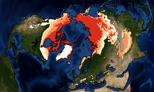
多年冻土约占地球陆地表面的20%,即2500万平方公里,相当于北半球陆地面积的四分之一。相比之下,大陆冰川和冰盖(不包括海冰)仅有1600万平方公里。
根据多年冻土覆盖总面积的比例,通常会按纬度(或海拔高度)进行区分:
- 连续多年冻土带(地表面积占比在80%以上),
- 不连续多年冻土带(地表面积占比在30%到80%),
- 零散多年冻土(地表面积占比在30%以下),
- 孤立多年冻土。
多年冻土主要存在于高纬度地区,而在高海拔山地则也有分布。在阿尔卑斯山脉,海拔约2500米以上地区的北侧是不连续多年冻土的潜在分布区,在3500至4000米以上的地区则是更为连续的多年冻土。根据模型计算,法国阿尔卑斯山多年冻土的面积为1300 km²[2],是冰川面积(约500 km²)的两倍以上。
2. 多年冻土的结构
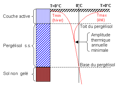
多年冻土的形成、维持和消失与气候密切相关。自然环境的变化和人为干扰会改变多年冻土的分布、温度和厚度,进而引起土壤热状况变化。多年冻土的垂直结构,特别是其含冰量,取决于气候、地形、地质和地貌等条件(图2)。
典型的多年冻土垂直热剖面图有三个清晰的层次:
表层。夏季温度会超过0℃,有季节性冻融交替,所以也称为活动层(active layer)。严格意义上的多年冻土仅指活动层以下、温度始终保持在0℃以下的地层。北极苔原的泥炭土中活动层可能仅有几十厘米厚,而在阿尔卑斯山脉少冰的岩石地形,活动层厚度可达3至7米。
多年不会融化的层是严格意义上的多年冻土。在最高温和最低温曲线(Tmax和Tmin)相交点以下,土层温度没有年际波动。年温度波动的最大土层深度很大程度取决于地层中冰的含量。在富含冰的多年冻土区可能仅有几米深,而在阿尔卑斯山的岩石区可达20到30米。
多年冻土下限(permafrost base)的深度取决于当地的平均气温和地温梯度,前者决定着冻土层的温度。因此,最深的多年冻土往往存在于最寒冷、最干燥的气候条件(低降雪量减弱了雪的隔热作用)。例如,加拿大最北部和西伯利亚的多年冻土深达数百米;1998年至2010年在阿尔卑斯山的钻探表明,在海拔3000米处,多年冻土的厚度可达100米以上。
地上与地下气候存在着复杂的相互作用,受到多种因素的影响,这些因素大多对气候变化非常敏感。由于底土和积雪层的导热率低,气温波动的影响通常会随着土层深度的加大而衰减。地表温度变化和多年冻土深度变化之间通常有一个时间差,在多年冻层深厚地区(北美、西伯利亚等地),滞后期的时间可达几百到几千年;而在多年冻层较薄的地区(如阿尔卑斯山等地区),时间差通常以年或几十年来计算。
3. 多年冻土和高山石冰川
任何类型的土壤都可能受到多年冻土的影响,无论是基岩还是沉积物。
对于岩性山体,其岩石有或多或少的裂隙,并被冰“胶结”。这里冰只存在于岩石裂缝中,其所占比例有限,在裂隙很少的岩石中甚至几乎为零,但对岩体的稳定性起着重要作用。
对于地表形态,多年冻土由岩石碎屑(崩积层、冰碛石和碎石)和冰(积雪压实、雪崩流和渗透水冻结)构成。这里多年冻土的形成取决于海拔高度(在法国所在的纬度这个高度通常高于2500米)、裸露程度与地貌环境(地表是否存在冰川,是否存在起隔热作用甚至作为冷阱的粗碎屑沉积物)、地形特征(遮阴作用、冷空气碗(cold air bowl)效应等)。
地表形态中多年冻土的标准结构包括以下几个主要部分:
- 一个厚达几米、导热性不良、季节性冻融的表层,即活动层;
- 一个由冰和岩石碎屑混合物构成的多年冻层,可能是均质(“冰混凝土”饱和度为30%至40%)也包括局部的异质性(既有被冰透镜体“过饱和”的多年冻土,也有含有少量空气和融冰的“不饱和”多年冻土,融水流动的通道和积水处等)。
- 一个很少冻结的基岩层或由未冻结的不饱和碎屑组成的第三层。
冰混凝土层中冰的比例是地貌动态的决定因素。如果冰混凝土中的冰饱和或过饱和,多年冻土就可能沿着山坡缓慢移动,以岩石冰川形式到达海拔较低的地区,这在法国阿尔卑斯山区非常多见,从马尔康杜(Mercantour)直到瓦努瓦兹(Vanoise)。

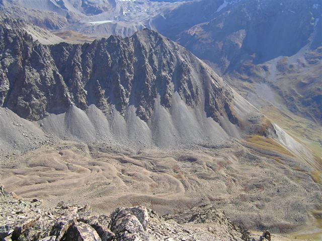
石冰川(rock glaciers)在山地景观中清晰可见,是多年冻土最明显的指示指标之一,其分布范围和对气候波动的响应差异都具有重要意义。石冰川主要分布在冰川不能充分发育且相对干燥的地区。构成石冰川的岩石碎屑和冰混合物在倾斜基底上蠕动,形成由隆起的脊和陡峭的锋相嵌套的特殊形态(图3)。
石冰川存在与否,以及其形态和功能取决于岩石碎屑和冰之间数量的可变平衡。在区域尺度上,这取决于气候和地质环境;在局地尺度上,则由地形气候和地貌环境[3]所决定。
根据所观察到的多样的环境条件,说明大多数石冰川起源于冰缘(即冰来自于将埋压在碎屑下的雪和深层冻结水),但并不排除冰川冰的存在(即最初是由地表的雪粒压实形成的)。最后应该指出的是,无论冰的来源如何,只有多年冻层的温度才是石冰川发育和维持的关键因素。
石冰川沿斜坡流动,填满高处的山谷,搬运大量物质,随着第四纪气候的波动,石冰川的发育速度也不断变化。如同完全由冰构成的真实冰川一样,石冰川在中长期内也会受气候变化的影响并留下明显的痕迹。虽然冰川冰碛的规模很小,但是在冰川融水的作用下不断移动,因而虽然阿尔卑斯山的石冰川位置没有发生改变,但是冰舌已经推进到了海拔1500米处。需要指出的是,只有最高处的石冰川是最近才形成的,仍然含有冰且可能还在移动。一般认为石冰川“活动”的极限高度(阿尔卑斯山区是在2500到3000米之间)和不连续多年冻土分布下限大致相当。在海拔更低的地方可能分布着“零散”或“孤立”多年冻土,但是只分布在非常特定的地形和温度条件下,如受冷空气影响的多孔或喀斯特化岩石[4]:在阿尔卑斯山麓查特(Chartreuse)和韦科尔(Vercors)地区称为“冷岩屑(cold scree)”和“冰盒(ice boxes)”。
4. 与冻土合并有关的风险
高山多年冻土几十年来一直在响应气候的变化,如冰川消融。在很多高山地区,多年冻土的温度已经上升到接近0℃。与此同时,活动层(即夏季融化的表层部分)变厚,地下冻结层的流变性显著改变。最终,高山多年冻土的分布下界会逐渐升高。
高山多年冻土下部边缘的演变(法国所在纬度附近,大约位于海平面以上2300至3200米之间),与气候失衡,这一变化引发了地质灾害及其它相关风险。事实上,由于多年冻土内部冰的减少,内聚作用消失,多年冻土上部的稳定性降低,使得多年冻土退化,进而导致重力塌陷、冰缘失稳和融冰急流等现象激增。
多年冻土暖化后会影响国土安全,主要有四个方面:
- 由于冰川融化,碎屑堆积物沉降已经影响到瑞士和法国的一些滑雪场和高海拔地区的一些设施[5];
- 在较陡的山坡冰冻碎屑堆积物失稳首先会使内部形变加速(在阿尔卑斯山有很多这样的案例),随后会引发冰冻体破裂,从而使得整个堆积物发生移动(乌巴耶的Le Bérard石冰川就是这样的[6]);
- 高海拔地区的岩石墙体受重力过程影响的频率增加,墙体连接处的冰融化可能是布伦瓦和德鲁斯最近发生墙体崩塌的原因[7];
- 融岩流和泥石流的频率增加,这可能是由于多年冻土的活跃层厚度增加(如瑞士阿尔卑斯山区瓦莱州Ritigraben地区的泥石流[8]和法国萨瓦省兰斯列维拉德的Col du Lou石冰川),或是由于岩石沉积物输入增加,在发生大的降雨事件后出现移动(如发生在上萨瓦省阿曼塞特的泥石流)。
参考资料及说明
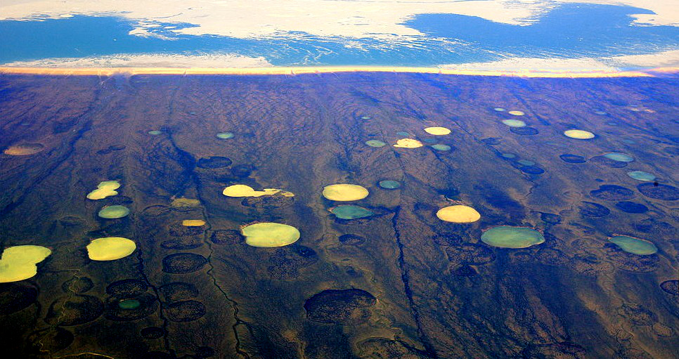
封面照片:2008年加拿大哈德逊湾泥炭沼泽上的多年冻土解冻池。[来源:Steve Jurvetson[CC BY 2.0],维基共享资源]
[1] Müller S.W. (1947) Permafrost and permanently frozen ground and related engineering problems. J.W. Edwards ed., 231 p.
[2] Bodin X., Lhotellier R., Schoeneich P., Gruber S., Deline P., Ravanel L. & Monnier S. (2008) Towards a first assessment of the permafrost distribution in the French Alps. Swiss Geoscience Meeting, 21-23 November 2008, Lugano
[3] 当地的地形和斜坡暴露条件
[4] 有裂缝和溶蚀洞,如石灰岩
[5] Fabre D., Cadet H., Lorier L. & Leroux O. (2014) Detection of permafrost and foundation related problems in high mountain ski resorts. IAEG Congress Torino, in Lollino et al, Springer, vol 1, paper 60, 321-324
[6] Schoeneich P., Bodin X., Echelard T., Kaufmann V., Kellerer-Pirklbauer A., Krysiecki J.-M. & Lieb G.K. (2014) Velocity changes of rock glaciers and induced hazards. in Lollino G., Manconi A., Clague J., Shan W., Chiarle M. (eds): Engineering Geology for Society and Territory – Volume 1, Springer, pp. 223-227. DOI: 10.1007/978-3-3-319-09300-0_42
[7] Ravanel L., Deline P. et al (2007) Ecroulement en haute montagne à permafrost : l’exemple du petit Dru (Massif du Mont-Blanc). Annual meeting of the Société Hydrotechnique de France (Nivologie-Glaciologie), Grenoble
[8] Rebetez M., Lugon R. et al (1997) Climatic changes and debris flows in high mountain regions: the case study of the Ritigraben Torrent (Swiss Alps) – Climatic Change 36, 371-389
环境百科全书由环境和能源百科全书协会出版 (www.a3e.fr),该协会与格勒诺布尔阿尔卑斯大学和格勒诺布尔INP有合同关系,并由法国科学院赞助。
引用这篇文章: SCHOENEICH Philippe, FABRE Denis (2024年11月4日), 多年冻土, 环境百科全书,咨询于 2026年7月25日 [在线ISSN 2555-0950]网址: https://www.encyclopedie-environnement.org/zh/sol-zh/permafrost-2/.
环境百科全书中的文章是根据知识共享BY-NC-SA许可条款提供的,该许可授权复制的条件是:引用来源,不作商业使用,共享相同的初始条件,并且在每次重复使用或分发时复制知识共享BY-NC-SA许可声明。