


生物圈,水圈和冰冻圈模型
本文展示了大气下垫面在数值天气预报模型中的重要性,生物元素(生物圈)、空气-水界面间的水分交换(水圈)和冰面(冰冻圈)的影响带来了一个更为复杂的“地球系统”。这个多样而又复杂的系统在人为土地利用变化和全球气候变化的影响下,仍在继续演变。
1. 引言
科学界已有共识,在数值天气预报中需要准确地描述地表环境。虽然复杂的地球系统需要在实际应用中适当的概化或简化,但在模拟空气和水交界处的水库和相应的径流(描述水库之间的流动)时,基本要素是确定的。我们需要在时间维度、空间维度及更长的时间尺度(如:月、季)上改善预测结果、提高可靠性,将地表过程变化融入数值天气预报模型,在天气预报和环境应用中同样也应该如此。
包括海洋表面在内的所有的开阔水面中都储存着能量,它决定了水面温度以及风、浪和洋流的运输交换能力[1]。这些能量很重要,尤其是在热带,因为它能够在大尺度上调节天气和气候变化。局部区域的变化对全球都会有影响,如:微风、大气边界层变化、雾的形成、强降水和局地降水以及海浪和海冰的相互作用。
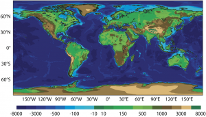
地球表面的特征包括:每日和季节周期内的剧烈波动、地表和大气的高度耦合以及水和能量储存的记忆效应[2]。在预测模型中,地表的作用就是在分钟至数十年的时间尺度上描述水循环和能量流动。因此,为了更好地描述物理机制以增强预报可靠性,地表的模拟[3],[4]是研究中必不可少的内容。我们需要精确的了解如:地表形态、土壤和植被性质、海水深度[5]等地形地貌知识。
在中纬度区域,地球表面与大气的耦合机制体现在对温度、低对流层湿度和云等气象参数有影响的蒸发-降水反馈调节机制[6]上。在高纬度地区和山区,雪的高反照率[7]和绝热能力隔离了地表和大气,导致冬季在地表观测到逆温现象。
陆面过程除了会影响天气预报中对气象要素的预测精度外,也会影响当地居民的生产生活(农业、交通运输业、可再生能源产出)。极端情况下,忽视陆面过程导致的天气预报偏差还会对生命和财产有直接威胁,因此我们需要进行陆气相互作用的模拟来提高区域天气预报的精度。
近些年设立的气象中心分别为模型模拟和海洋观测数据同化两个功能搭建了数字化平台。平台设立的目标不仅是为气象预报提供更好的地表特征,还要像天气预报一样预测并提供现在和未来的地表数据。这些平台中,最贴近现实的物理和生物过程是通过物质流、能量流以及(生物圈、水圈和冰冻圈)与大气层的组成成分交换形成的参数化方案。
2. 生物圈
生物圈是由地表的生物(特别是植物生态系统)及生物地球物理过程组成的。大量敏感性分析结果表明,对地表生物物理过程的参数化方案会显著影响降水、低空风和遮阴温度等气象变量的预测结果。

(Transpiration散发;Evaporaion蒸发;Condensation凝华;Precipitation降水
Snowmelt runoff融雪径流;Surface runoff地表径流)
模型中所采用的地表模块包括不同空间尺度的地表类型,例如具有观测站点的地表植被、农田,大陆尺度的流域以及洋盆等。这些地表模块对主要反馈机制的物理过程进行了简化,因此某些时候会受较大的系统误差影响。
在数值天气预报中考虑地面模块的主要目的是在大气模式的下限计算温度和比湿度。我们需要这些变量来估算与大气交换的流量、热量、水和运动量。
近年来,时间标度的概念被引入地表模块中。它区分了直接对地表作用力作出反应的表层以及对作用力反应不敏感的深层,后者作为地表的缓冲层,对模拟水循环和土壤温度中出现的异常现象更为重要(见:Do we risk having a water shortage?),例如,永久冻土演变过程的模拟(见:The permafrost)。
地球上所有生物都参与的碳循环(见: A Carbon Cycle Disturbed by Human Activities),在数值天气预测模型中基本上被简化为植被循环。它对于地表能量和移动量的平衡十分重要。在气候模拟中,植被、土壤和海洋的生物地球化学过程的表征是基础,因为它调节了大气中二氧化碳的含量,例如光合作用这一强大机制就可以吸收大气中的二氧化碳。
作为欧洲哥白尼计划的一部分[8],ECWMF 提供监测地表 CO2 浓度变化的服务。其目的是与森林监测系统的观测结果互相补充,共同为政府间气候变化委员会(IPCC)提供监测结果(link to article on IPCC)。
因此,植被和其他生物相关方面的描述,例如对水分胁迫条件的反应和生物地球化学方面(存量和生物量变化)的描述,可以促进监测活动和提高预报质量。一些研究已经证明了季节植被循环的描述对蒸发的影响。叶片指数[9]随季节和水分胁迫条件而变化,通常由卫星数据(如MODIS传感器)进行监测。这些数据能够构建一个更真实的植被状态下的月尺度上的气候态,并改善水和二氧化碳与大气交换的模拟。
3. 水圈
自然界水流的主要存在形式是降水、蒸发和径流。陆地水的贮存形式可以分为四类:
- 土壤(在根部储水,且通常以液体或冰的形式储存在地下水位较低的部位)
- 植被(储水能力很强)
- 雪(水分含量在10%-15%间浮动)和冰川
- 湖、河等水资源汇集区
地表水文图描述了地表水、大气水以及土壤水之间的交换形式。为了体现土壤的蓄水情况,Manabe[10]首次将地表状况引入气候研究的大气环流模式中,来表征土壤水储量的影响。该模型比较简单,仅考虑单一的水分储存情况,并根据土壤含水量变化来调节陆表蒸发量的大小。这些模式随后演化为两层或多层模型[11],具有更精细的垂直结构。渗透通常用Richards[13]在非饱和土壤中推广的达西定律[12]来表示,并在流域水文研究中取得了一些进展。这促进了土壤模型的发展,比如利用ECMWF[14]模型中土壤模型与河流径流模型耦合来为GloFAS(Global Flood Awareness System project)[15]项目提供洪水预报。
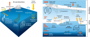
(Wind 风;Sensible heat 显热;Air-Sea interactions 空气-海洋交互作用;Precipitation 降水;Visible radiation 可见光辐射;Evaporation 蒸发;Penetrating radiation 穿透辐射;Langmuir circulation 朗缪尔环流;Ocean currents 洋流;Ekman transport in the Northern Hemisphere 北半球的埃克曼输送;Large-scale advection 大型平流;Microphysical processes 微物理过程; Atmospheric mixing 空气混合; Ponding 积水; Momentum fluxes 动量通量;Brine injection 注入海水;Deformation 变形;Turbulent fluxes 湍流通量;Conduction 传导;Biogenic emission 生物排放;DMS production 产生气态二甲基硫化物;Lead processes 主导过程;Entrainment 卷吸现象;Ocean mixing 海水混合;Upwelling 上升流;Transmission 输送;Albedo 反照率;Solar heating 太阳能加热;LW emission 长波发射;LW cooling 长波冷却;Subsidence 沉降)
海洋与大气交换热量和动量,因此持续影响数值天气预报结果。海洋与大气的热量交换取决于海洋表面温度,海洋表面温度不仅受天气条件的影响,也受洋流(如北半球的墨西哥湾暖流和日本暖流)以及厄尔尼诺现象这种对大陆和地表区域都有强烈作用的天气现象的影响。
在大的时间尺度以及与全球变暖的相互作用[16]方面,建立海洋模型的需要尤其明显,而且想要在几天内对极端天气事件(如热带气旋[17])进行预测也需要建立模型(参见热带风暴:发展与形成)。气象学研究经常集中在与风、波浪和海洋边界层相互作用的地面交换上。这些研究的目的是改进海洋预报,特别是海浪高度,这是所有海洋资源运输和开采活动的先决条件。
大多数气象中心还没有考虑在其业务链中将不断发展的海洋模型与大气模型相结合。然而,将海洋引入气象预报是一个重要的发展前景,将对季节耦合预报的挑战作出反应,海洋是这种预报的主要可预测性信号来源之一。
4. 冰冻圈
雪和冰(海洋和大陆)是重要的能量库,可以通过释放或吸收潜热来延缓大气和地面的变暖或变冷。冰雪是重要的能源储蓄库,可以通过释放或吸收潜热延迟空气和土壤的升温和降温。由于多达90%的体积都充满空气(新鲜的积雪密度可达 100kg/m3),因此积雪是很有效的绝热体。控制积雪演变的过程十分复杂,用于天气预报的数值模型中使用的方案只描述了与质量相关的温度和压实的影响,导致密度的增加,以及反照率的变化。雪也是一个非常重要的淡水水库,调节着河流的流量,特别能在高纬度地区发挥作用。
积雪和冰对天气和气候预报的质量有很大的影响。事实上,由于反照率的变化(参见大气层和地表的气态外壳),雪的存在可以使地球-大气界面对太阳辐射的吸收达到4倍。这种反照率与地表温度反照,有助于加速季节和气候的变化。
在高纬度和山区,雪也是重要的能量和水的储存库。因此,我们需要在所有预报时间节点上准确描述雪量,这将直接影响下垫面的水文和温度条件。
许多雪模型已被开发进行各种应用,如成雪过程研究、径流和雪崩预测,以及大气模型。Brun等人[18]详细地分析了现有模型及应用状况,并形成了大气模型方案(全球和区域性)。对现有模式及其应用进行了详细分析,得出了大气模式(全球和区域)方案。这些方案的目的是在大气的较低限度上提供条件,以便在积雪地区上空进行耦合。雪的含水量和积雪与地面之间的能量流动也有助于实现这一目标。还应特别注意雪在控制地冰大气耦合中的保温作用。
对雪-大气耦合[19][20]的更好表征使我们可以改进日-季时间尺度上对地表流量的预测。同样,海冰模拟能够体现年际演变[21],并帮助减缓全球变暖导致的海冰范围的缩小和厚度的减少。
5. 地球系统
地表-大气能量、水和碳(以及其他成分)交换过程的表征对于模拟和预测地球系统状态随时间的演化至关重要。
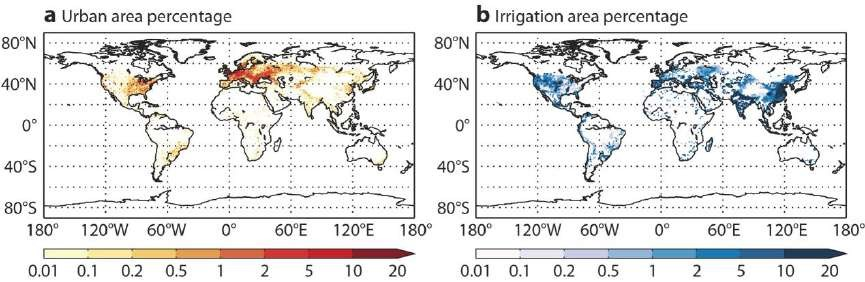
陆地生态系统的研究是科学研究及其业务监测的重中之重,因为可持续发展和社会经济在很大程度上依赖于它。人类占据了大部分的城市生态系统,而城市生态系统在气象水文模型中往往表现不太好,因为城市化地区只占不到1%的大陆表面积。
很快,未来的地球系统建模不仅仅会简化考虑温室效应的天气尺度,而且在所有的时空尺度都要考虑人为因素对自然循环的影响。这就需要我们建立全球地表水、能量和生物量的循环模型,模型的空间分辨率要足够高以体现主要物理过程,这是地球系统的数值模拟必须首要考虑的事。
农业生态系统的粮食生产对气候变化的影响最为敏感,且与人类社会息息相关,因此需要特殊考虑。大多数人为管理的农田和林地为人类提供资源,需要日常监测以模拟灌溉和砍伐情况。这些行为改变了参与蒸散发的水量和影响风速的表面粗糙度,因此会使当地和其他地区原本的预测结果产生偏移。
对地球系统地表的这些组成部分的研究进展基于可获取的观测数据,特别是卫星遥感。因为卫星遥感是实现全球同质覆盖、高时空精度观测的最佳手段。由于哥白尼哨兵项目和欧洲航天局(ESA)的地球生物质探测计划,全球大陆表面实时监测的遥感可用数据将会增加。这将有可能作为数据同化的一部分,用来识别预报模型中的弱点,并纠正分析其中的随机误差和系统误差,(见气象数据的同化)。
尽管我们已经有了以上数据集,但它们都不足以完整刻画地表特征。还需要一种综合的水文气象和气候表面评估方法,如文中提议的记录大气再分析质量的方法[22]。
在未来,像SURFEX[23]这样的地表建模平台将鼓励科研人员进一步开展关于地球系统内自然和人为活动复杂性的复合研究。这些都是气象部门为满足环境预测日益增长的需求而做出的重要努力。
参考资料及说明
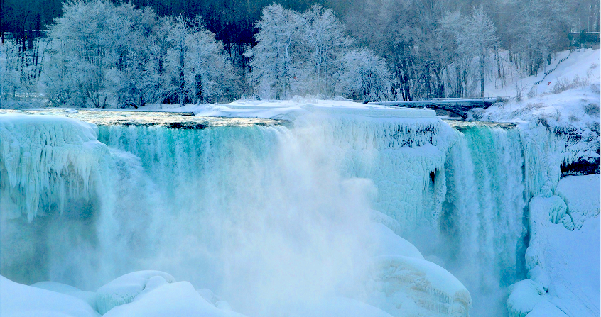
封面照片:冬季的尼亚加拉瀑布,美国部分
[1] Belcher SE, Hewitt HT, Beljaars A, Brun E, Fox-Kemper B, Lemieux JF, Smith G, Valcke S.2015: Ocean-waves-sea-ice-ice-atmosphere interactions. In: Seamless Prediction of the Earth System: from Minutes to Months, WMO-No. 1156. World Meteorological Organization.
[2] Dirmeyer, P., C. Peters-Lidar, G. Balsamo, 2015: Land Atmosphere Interactions and the Water Cycle, In: Seamless Prediction of the Earth System: from Minutes to Months, WMO-No. 1156 2015. World Meteorological Organization.
[3] Balsamo, G., S. Boussetta, E. Dutra, A. Beljaars, P. Viterbo, and B. Van den Hurk, 2011: Evolution of land surface processesin the IFS, ECMWF Newsletter, 127, 17-22.
[4] Balsamo, G., A. Agusti-Panareda, C. Albergel, A. Beljaars, S. Boussetta, E. Dutra, T. Komori, S. Lang, J. Munoz-Sabater, F.Pappenberger, P. de Rosnay, I. Sandu, N. Wedi, A. Weisheimer, F. Wetterhall, E. Zsoter, 2014: Representing the Earth surfaces in the Integrated Forecasting System: Recent advances and future challenges, ECMWF Tech. Memo. 729 October 2014.http://doi.org/10.13140/2.1.4248.0324.
[5] 测深仪测量海洋深度。
[6] Beljaars A., Viterbo P., Miller M. and Betts A. 1996. The anomalous rainfall over the United States during July 1993: Sensitivity to land surface parameterization and soil anomalies. My. Weather Rev., 124, 362-383.
[7] 反照率是没有被地表吸收的太阳能所占的比例。
[9] 叶面积指数表示单位地面上绿叶覆盖的面积。
[10] The atmospheric circulation and the hydrology of the earth’s surface. My. Wea. Rev., 97, 739-774.
[11] Noilhan J. and Planton S., 1989: A simple parametrization of land surface processes for meteorological models. My. Wea.Rev. 117, 536-549.
[12] Darcy H., 1856: Les fontaines publiques de la ville de Dijon, V. Dalmont, Paris.
[13] Richards, L. A., 1931: “Capillary conduction of liquids through porous mediums”. Physics. 1 (5): 318-333.
[14] Balsamo, G., P. Viterbo, A. Beljaars, B. van den Hurk, M. Hirschi, A. K. Betts, and K. Scipal, 2009: A Revised Hydrology for the ECMWF Model: Verification from Field Site to Terrestrial Water Storage and Impact in the Integrated Forecast System.J. Hydrometeor, 10, 623-643.
[15] GloFAS, | http://globalfloods.jrc.ec.europa.eu/
[16] Balmaseda, M.A., K.E. Trenberth, and E. Källén, 2013: Distinctive climate signals in reanalysis of global ocean heat content, Geophys. Res. Lett., vol. 40, pp. 1754-1759. http://dx.doi.org/10.1002/grl.50382
[17] Glenn, S. M., Miles, T. N., Seroka, G. N., Xu, Y., Forney, R. K., Yu, F., et al. 2016: Stratified coastal ocean interactions with tropical cyclones, 7 SP. http://doi.org/10.1038/ncomms10887
[18] Brun, E., Z. Yang, R. Essery, and J. Cohen, 2008: Snow-cover parameterization and modeling. Snow and Climate, R. L. Armstrong and E. Brun, Eds., Cambridge University Press, 125-180.
[19] Boone, A., and P. Etchevers, 2001: An intercomparison of three snow schemes of varying complexity coupled to the same land-surface model: Local scale evaluation at an Alpine site. J. Hydrometeor, 2, 374-394.
[20] Dutra, E., P. Viterbo, P. M. A. Miranda, G. Balsamo, 2012: Complexity of snow schemes in a climate model and its impact on surface energy and hydrology. J. Hydrometeor, 13, 521-538. doi:10.1175/JHM-D-11-072.1.
[21] Vihma, T., 2014: Effects of Arctic Sea Ice Decline on Weather and Climate: A Review. Surv Geophys. 35: 1175.doi:10.1007/s10712-014-9284-0.
[22] Balsamo, G., Albergel, C., Beljaars, A., Boussetta, S., Brun, E., Cloke, H., Dee, D., Dutra, E., Muñoz-Sabater, J.,Pappenberger, F., de Rosnay, P., Stockdale, T., and Vitart, F.: ERA-Interim/Land: a global land surface reanalysis data set,Hydrol. Earth Syst. Sci. 19, 389-407, doi:10.5194/hess-19-389-2015. 2015.http://www.hydrol-earth-syst-sci.net/19/389/2015/hess-19-389-2015.html
[23] Masson, V., Le Moigne, P., Martin, E., Faroux, S., Alias, A., Alkama, R., Belamari, S., Barbu, A., Boone, A., Bouyssel, F.,Brousseau, P., Brun, E., Calvet, J.-C, Carrer, D., Decharme, B., Delire, C., Donier, S., Essaouini, K., Gibelin, A.-L., Giordani,H., Habets, F., Jidane, M., Kerdraon, G., Kourzeneva, E., Lafaysse, M., Lafont, S, Lebeaupin Brossier, C., Lemonsu, A.,Mahfouf, J.-F., Marguinaud, P., Mokhtari, M., Morin, S., Pigeon, G., Salgado, R., Seity, Y., Taillefer, F., Tanguy, G., Tulet, P,Vincendon, B., Vionnet, V., and Voldoire, A.: The SURFEXv7.2 land and ocean surface platform for coupled or offline simulation of earth surface variables and fluxes, Geosci. Model Dev. 6, 929-960, doi:10.5194/gmd-6-929-2013, 2013.
环境百科全书由环境和能源百科全书协会出版 (www.a3e.fr),该协会与格勒诺布尔阿尔卑斯大学和格勒诺布尔INP有合同关系,并由法国科学院赞助。
引用这篇文章: BALSAMO Gianpaolo (2024年3月11日), 生物圈,水圈和冰冻圈模型, 环境百科全书,咨询于 2026年7月23日 [在线ISSN 2555-0950]网址: https://www.encyclopedie-environnement.org/zh/air-zh/biosphere-hydrosphere-and-cryosphere-models/.
环境百科全书中的文章是根据知识共享BY-NC-SA许可条款提供的,该许可授权复制的条件是:引用来源,不作商业使用,共享相同的初始条件,并且在每次重复使用或分发时复制知识共享BY-NC-SA许可声明。