


高山冲积地貌与生物多样性
河道沿岸的植物群落在水陆交界处为生物提供了特定的栖息地,水、沉积物、能量流在此也与植物群落相互作用。河流的动态变化是生态和水文过程的原动力,因为它造成环境因素在时间和空间上的高度异质性。不论是从河流源头到河口,还是从开阔水域到被洪水周期性淹没的回水区,生物多样性的组成各不相同,而且其组成变化也与地下水流密切相关。由于河流对气候变化和影响流域的人类活动高度敏感,在过去的两个世纪,大多数河流都受到了人为干扰,导致生物多样性严重受损。目前生物多样性的恢复和管理需要依靠河流动态变化的可持续性,以确保河流栖息地的定期更新。
1. 植物对洪水的适应
冲积区植物群落主要位于水域和陆地之间的过渡区,受河流活动的影响较为明显[1]。植物对外界环境的压力产生了适应性,使它们能够在受水流、能量和物质流影响的栖息地中定居、发育和繁殖[2]。植物的适应性主要表现为:
- 高度发达的根系,能将植物牢牢固定在沉积物中,抵抗水流侵蚀;
- 能够通过埋藏在沉积物中茎和枝再发育;
- 能够通过无性繁殖(根茎)迅速定植于有利环境的能力;多年生地下茎,或长或短,有分枝或无分枝,叶片退化为极小的鳞片状,每年长出不定根,顶芽产生气生茎,稍埋于地下,水平生长或与地表齐平,通过水和风散播种子;
- 能够适应长时间缺氧;
洪水发生的频率、强度、范围和时间是随机变化的,植物的适应性可以抵御洪水带来的各种压力。河流的动态变化产生了新的环境,从而创造了新的栖息地,这就是生物多样性丰富的原因。如柳树和杨树,其传播和繁殖与干扰密切相关。洪水之后保留的沉积物为植物萌发后的生长发育提供了有利环境,且这种环境不论是对一年生先锋物种还是对多年生大树的成长来说都需要长期保持稳定。
2. 河岸景观的时空结构
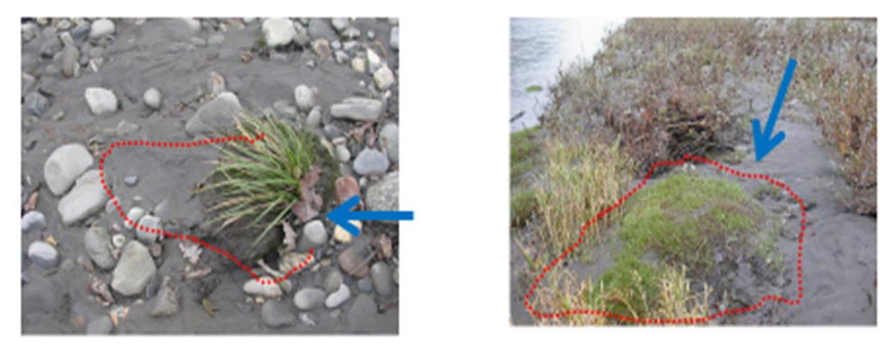
左图:先锋植物(Agrostis stolonifera)生长在鹅卵石之间,凭借其强大的根系抵御水流冲刷,并固定沉积物。右图:沉积物增多,草丛扩张,其他物种(Calamagrostis pseudophragmites)开始出现。
在冲积平原水流中,运输沉积物的流量和大小及植被是主要的环境因子。植被会固定河岸,截留沉积物(图1),然后造成大型碎屑堵塞,影响水流分布。物理过程和生物过程之间的相互作用导致陆地和河流中栖息地的分布产生变化[1]。在这些生态系统中,因为栖息地的优势竞争物种与适应中等干扰水平的逃逸物种共存[3],所以生物多样性较为丰富。这些植物群落在空间上有三个维度:
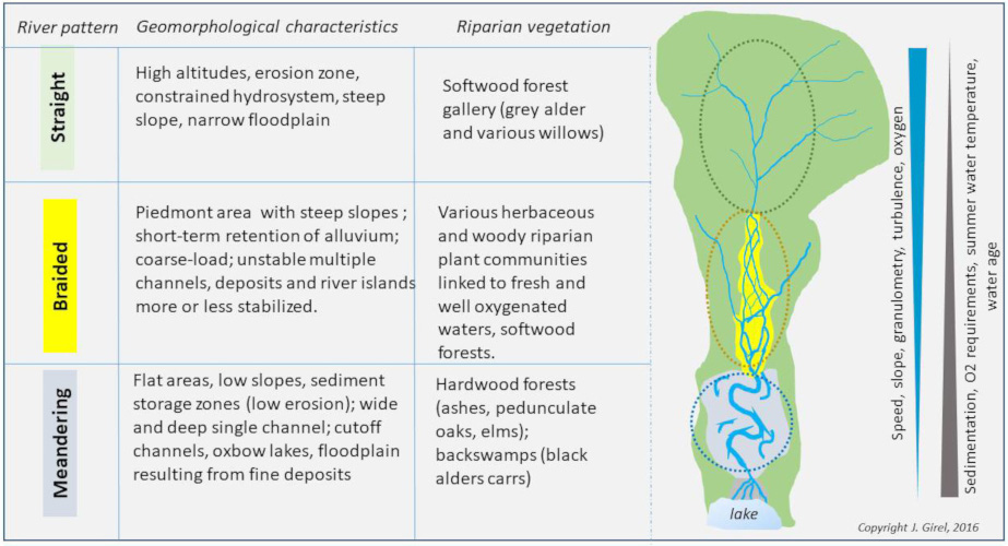
River pattern(河流类型)、Geomorphological characteristics(地貌特征)、Riparian vegetation(河岸植被)、Straight(顺直型)、High altitudes,erosion zone,constrained hydrosystem,steep slope,narrow floodplain(高海拔、侵蚀地带,受限制的水系、陡坡、狭窄的洪泛区)、Softwood forest gallery(grey alder and various willows)落叶林(各种杨树和柳树);Braided (辫状河)、Piedmont area with steep slope;short-term retention of alluvium;coarse-load;unstable multiple channels,deposits and river islands more of less stabilized(具陡坡、冲积物短期滞留、荷载较粗、不稳定多河道、沉积物和河岛已趋向稳定)、Various herbaceous and woody riparian plant communities linked to fresh and well oxygenated waters,softwoodforests(各种各样的草本和木本河岸植物群落依与含氧量充足的淡水水域相连);Meandering(蜿蜒型)Flat areas, low slopes, sediment storage zones(low erosion); wide and deep single channel; cutoff channels, oxbow lakes, floodplain resulting from fine deposits(平地、低坡、泥沙淤积区(低侵蚀)、宽深的单一河道、截流河道、牛轭湖、细小沉积物形成的洪泛区)、Hardwood forests (ashes,pedunculate oaks,elms); backswamps (black alders carrs) (森林(灰栎、橡树、榆树)、沼泽地(桤木林))
- 纵向分布。从河流源头到河口,水、物质和养分的供给增加;然而,河床坡度和流速减小。因此,地貌发生了变化(图2),河流中段生物多样性最高[4]。例如,800米以下的辫状河地区[5],白赤杨林下的灌木和草本植物丰度最高。
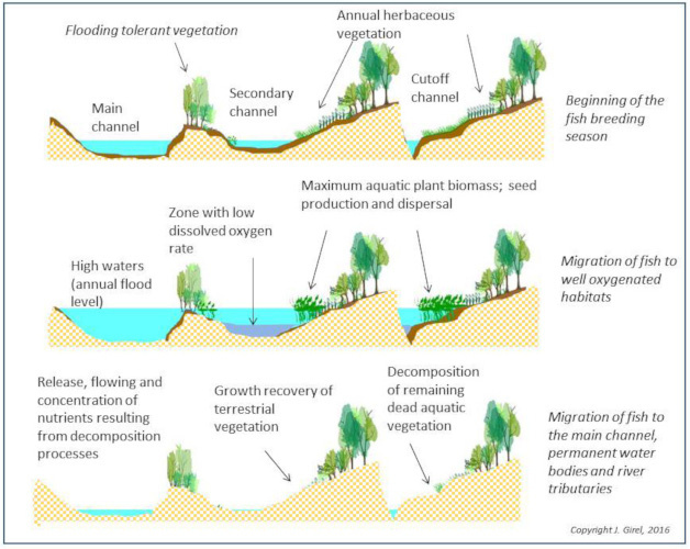
Beginning of the fish breeding season(鱼类繁殖季节开始);Main channel;flooding tolerant vegetation;Secondary channel;annual herbaceous vegetation;cutoff channel(主河道;抗洪植被;次河道;一年生草本植被;截流河道);Migration of fish to well oxygenated habitats(鱼类迁移到含氧量高的栖息地);High waters(annual flood lever);zone with low dissolved oxygen rate;maximum aquatic plant biomass;seed production and dispersal(高水位区(年洪水位区);低溶氧率区;水生植物生物量最大;种子成熟和传播);Migration of fish to the main channel(鱼洄游到主河道);Permanent water bodies and river tributaries:Release,flowing and concentration of nutrients resulting from decomposition processes;growth recovery of terrestrial vegetation;decomposition of remaining dead aquatic vegetation(永久水体和河流支流:分解过程中产生营养物质的释放、流动和浓缩;陆地植被的生长恢复;残留死亡水生植被的分解)
- 横向分布。水位的季节性变化导致河道横向的动态变化,并控制着冲积物的补充和养分的再分配[6](图3)。河道蓄水时间与到主河道的距离而变化。

Oak/Ash forests(quercus robur,fraxinus excelsior)growing on sandy well-drained soils生长在排水良好的沙质土壤上的橡树/白蜡林(Quercus robur, Fraxinus excelsior);Alder forest(alnus glutinosa)growing on silty/clay soils 桤木林(Alnus glutinosa)生长在淤泥/粘土上;Poplar forests(populus nigra)growing on coarse sand and gravel deposits生长在粗砂砾层上的杨树林(Populus nigra);Willow thickets(salix cinerea)growing on sandy soils生长在沙质土壤上的柳灌丛(Salix cinerea);White willow forests(salix alba)growing on fine sediment layers(silty sand)deposition over pebbles生长在鹅卵石细沉积(粉砂)上的白柳林(Salix alba);Shrubby willows(salix triandra) growing on recent alluvial sand deposits生长在新生冲积沙土上的一柳灌丛(Salix triandra);Perched aquifer(under-flows); middle level of the aquifer(river water table)冲积含水层(下流水位);含水层中层(河流水位)
- 垂直分布。生活在河道或陆地的物种和群落取决于临时地下水的流速和深度以及永久性地下水位的变化(图4)。
此外,河岸景观仍处于可重建的旧态和难以预测未来发展状态之间的过渡态。
3. 生态和水文过程
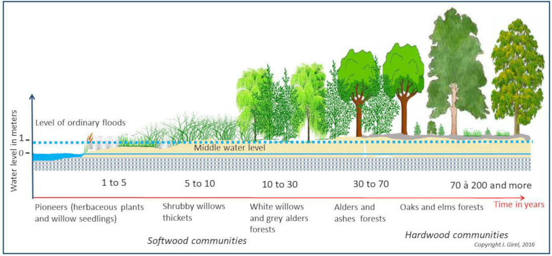
Pioneers(herbaceous plants and willow seedlings)先锋植物(草本植物及柳树幼苗);Shrubby willows thickets柳树灌木丛;White willows and grey alders forests 白柳和赤杨树林;Alders and ashes forests赤杨和重生林;Oaks and elms forests橡树和榆树林;Water level in meters水位(米);Level of ordinary floods普通洪水水位;Middle water level中间水位;Softwood communities针叶林群落;Hardwood communities阔叶林群落
植物演替。在稳定的沉积物上,植被会随着时间的推移而发生变化。已定居的植物物种会让位给具有竞争优势的新来物种。植物群落的组成,也就是生物多样性,将依草本、灌丛、针叶林、阔叶林进行演替(图5)。这种演变是由植物群落控制的内部生态条件变化(自生演替)或外部因素造成的。外部因素所导致的演变也称为异发演替模式,它是河道动态变化中最常见的演替模式,因为洪水带来的沉积物有利于新物种的形成。在演替的过渡阶段,异发演替模式将增加生物多样性。在真菌和细菌的参与下,最终的阔叶林在土壤中开始缓慢的自生演替(图5)。
分区。河流冲刷产生的沉积物由不同比例的黏土、粉砂、沙粒、砾石和鹅卵石组成。它们的厚度和结构决定了以地表和地下水文为特征的栖息地状况(图4)。物种会根据当地的环境条件进行自我更替与组织。与演替一样,一个或多个物种会成为这些区域的优势种(图6)。
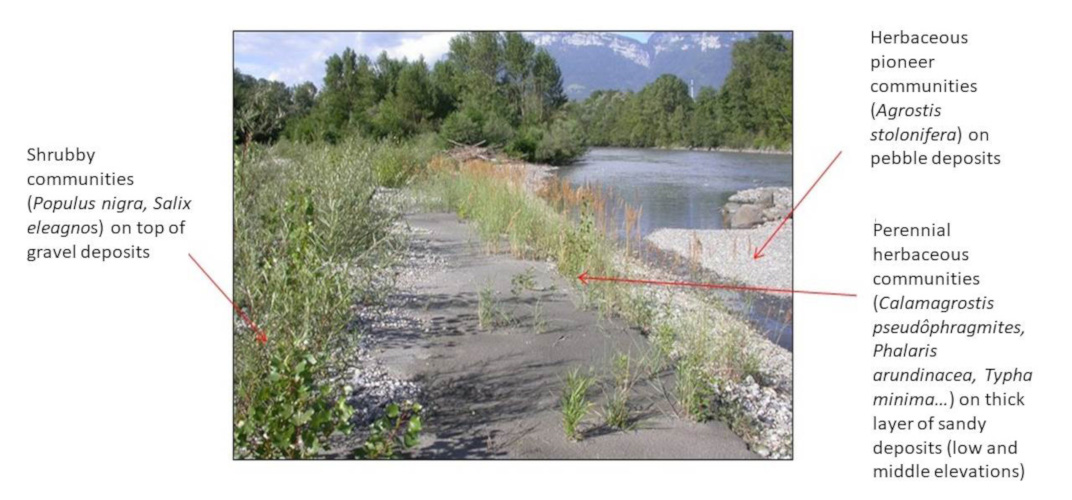
Shrubby communities(populus nigra)on top of gravel deposits砾石沉积物顶部的灌木群落(Populus nigra);Herbaceous pioneer communities(agrostis stolonifera)on pebble deposits鹅卵石沉积物上的草本植物先锋群落(Agrostis stolonifera);Perennial herbaceous communitieson(Calamogrostis pesudophragmites,phalaris orundinacea)thick layer of sandy deposits(low and middle elevations)沙质沉积物(中、低海拔)多年生草本植物群落(Calamogrostis pesudophragmites, Phalaris orundinacea)
水流量,运输负载,河流格局和植被。水流充足,河床负载丰富且流动性强时,河床坡面增大,以保证向下游的运输。然而,水流流速无法通过盐化过程将所有河床负载排出,因此河流床面升高。由此产生的多条河道和岛屿形成了一个辫状系统(图2、7a和8)。岛屿和河道的构成和寿命取决于洪水的强度和频率,这使得多孔沉积物上存在各种栖息地。河道为生长快速且需氧木本植物提供了良好的栖息环境,如灰桤木、黑杨树、沙棘、德国柳和各种灌木柳。

当河道流量大、河床负载少时,河道的输送能力超过了所消耗的能量,将导致河床加深,河道延伸,坡度降低,形成蜿蜒型,洪水从悬浮物中沉淀出细小的物质。这种河流模式栖息着黑赤杨、鼠李木或灰柳等植物,它们适应了流速慢、含氧低的水流和紧密的土壤(图2和7b)。
4. 人类活动的长期影响
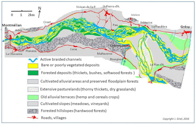
Active braided channel活跃的辫状河道;Bare of poorly vegetated deposits植被贫瘠的祼露沉积物;Forested deposits(thickets,bushes,softwood forests)森林沉积物(灌木、灌木丛、针叶林);Cultivated alluvial areas and preserved floodplain forests开垦的冲积地和被保护的洪泛森林;Extensive pasturelands(thorn thickets,dry grasslands)广阔的牧场(刺灌丛,干草地);Old alluvial terraces(hemp and cereals crops)古冲积梯田(大麻和谷物作物);Cultivated slopes(meadows,vineyards)斜坡耕地(草地,葡萄园);Forested hillslopes(hardwood forests)森林山坡(阔叶林);Rods,villages道路、村庄
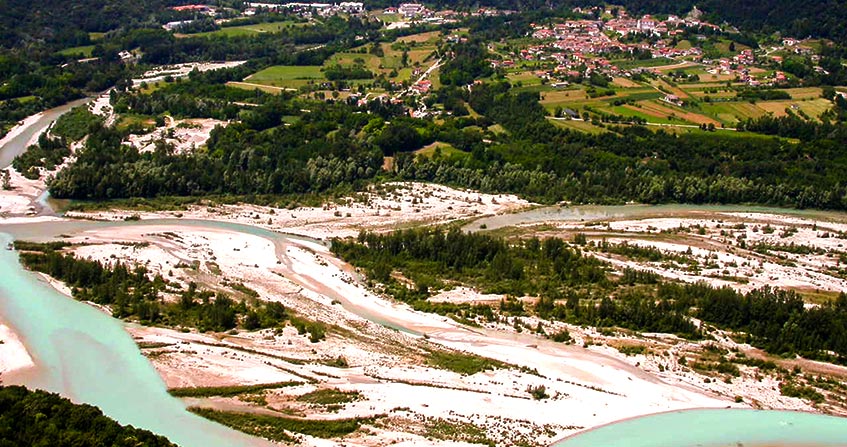
河型变化和生物多样性。阿尔卑斯山的河流流域受气候灾害和用途变化的影响,在过去经历了多次河流形态的蜕变[7]。例如,小冰河时期,欧洲和北美的冬季变冷,夏季变短。从15世纪初到19世纪中叶,持续400多年,由于降水量增加和裸露山坡的侵蚀,导致负载过重,引起皮德蒙特地区辫状河的发展。辫状河流景观具有植被丰富的岛屿和多条河道,是阿尔卑斯山景观的一个典型特征(图8),但其生物多样性可能最为丰富。这一假设在“天然”辫状河上得到验证[8],与中间干扰假设相一致[3]。
19世纪:冲积地貌结构改变。在19世纪,辫状河上建造了大量堤坝,通过引水、储水和排水工程控制流量(水、泥沙和能量),这些工程改变了堤坝河道外的冲积区[9]。
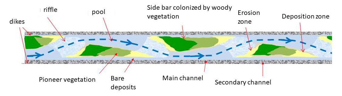
Dikes堤坝;Riffle浅滩;Pool水塘;Pioneer vegetation先锋植被;Bare deposits裸露沉积;Side bar colonized by woody vegetation被木本植被占领的侧边坝;Main channnel主河道;Secondary channel次生河道;Erosion zone侵蚀地区;Deposition zone沉积带
系统的简化[10]影响了景观层面的生物多样性[11]。另一方面,堤坝外,碱性沼泽不断扩大。在上升的人工河床中,溪流和水潭的演替导致侧坝的形成(图9)。这些移动的侧向沉积物是陡坡堤坝河流所特有,是通常生长在辫状水系中的植物的最后庇护所。
20世纪:生物多样性丧失。20世纪初以来,流域降水减少和裸地植被化对河流的动态变化产生了影响。山坡上减少的径流限制了侵蚀,大部分沉积物都储存在上游水力发电站中,引起负载不足,导致河床加深,河道中的砾石开采更加剧了这种情况,于是出现了稳定的侧向沉积。洪水在大坝的缓解作用下,已不足以调动河床负荷来更新水文地貌。另一方面,植被演替期,十年一遇的洪水会带来大量的沙土淤积,使河流岛屿和侧坝稳定性增加,导致植物演替末期特有的木质化植被同质化,从而引起生物多样性丧失。与河道相连的早期演替植物,如矮蒲草,正面临灭绝的威胁。同样,柳树(有六种)、德国红柳、沙棘、黑杨树和灰桤木(一种典型的高海拔树种)也处于濒临灭绝的危险中。具备自我再生能力的本地物种组成的异质群落正被同质、稳定的外来物种群落代替。
21世纪: 振兴河道。河流岛屿和边坝的植树造林降低了堤坝河道的承载能力,使其无法在洪汛期间提供运输服务。对被保护的冲积洪泛区需要进行适当开发。在可能的情况下,可以扩大河流的自由空间,或在堤坝外为冲积林、杨树种植园或湿草地和沼泽地预留的区域修建蓄水池。然而,为了确保人员和财产安全以及保护生物多样性,砍伐森林和平整河岛仍然是必要的步骤。河道内,生物丰富度取决于裸露空间的形成,因为植物演替将从这里开始。应禁止大树导致碎屑沉积物堵塞河道。

2010-10: The first individuals of dwarf bulrush are established (seeds produced by plants growing upstream) 2010-10: 第一批小香蒲个体诞生(上游生长的植物结出的种子);2013-8: Vegetative propagation of the dwarf bulrush over sand deposits 2013-8:小香蒲在沙地上开始营养繁殖;2014-7: Presence of many flowering stems (seed production) 2014-7:花茎出现(种子成熟);2013-8: Young individual of German Tamarisk (Myricaria germanica) newly established 2013-8:德国红柳(Myricaria germanica)新建立的幼小个体;2013-11: Rapid growth of the shrub 2013-11:灌木迅速生长;2016-6: Flowering and seed production2016-6:开花且种子成熟
21世纪:管理河流以保护生物多样性。为确保创造有利于冲积物种传播、发芽、生存和繁殖的栖息地,必须要保留水流和物质流。例如,2010年5月伊泽尔河遭遇十年一遇的洪水,重建了上一年冬天消失的侧边冲积扇。7月,黑杨树、几种柳树(如Salix daphnoides)、德国红柳和各种草本植物开始生长。随着德国红柳的茁壮成长,稀有物种黄柳也随之蔓延开来(图10)。由于建议对恢复后的水系进行自我调节,以促进冲积地貌的定期更新,管理者可使用两种物质流:固体流和液体流,但流量指标必须与水力发电厂的管理者协同进行测试。同时,还需要开展建模工作,以确定在振幅(河道保留流量[12])、范围和时间方面,应采用哪些人工扰动参数,并做出类似的适应性反应[13]。
5. 生物多样性恢复的参考状态
气候、高山殖民和辫状支流发展。就高山河流而言,在铁器时代(2700/2400 BP),后罗马时期(公元500-700 AD)和小冰河时期(1550-1850年),粗物质运输量显著增加。降雨量增加的主要原因是人类活动,如森林砍伐和农业发展。河道中的古沉积物可以很好的记录这种变化[14],这被视为辫状发育过程的起源。
古地图和参考状态的表示形式。在小冰河期,山麓河流提供了“植被覆盖岛屿的辫状河流系统”相关的全部栖息地(约40个植物群落)。18世纪和19世纪的地图(图8和[9])所表示的多样性表明,辫状河流系统提供了阿尔卑斯山冲积平原重新发育的所有特征[15]。许多生物多样性高的地区是由于人类开发种植植物所导致,所以回归自然状态在此存在争议[16]。此外,由于社会经济原因,恢复筑堤工程之前的地貌是不切实际的。
然而,通过提升河流的空间自由度可以显着增加物种丰富度。“珠链修复理念”的应用也证实,无需重建整个河道走廊就可以恢复其大部分生态潜力[17]。修复部分河流的动态变化能实现栖息地定期更新,这些栖息地能够成为生物多样性的储存库。如阿尔克河等河流中(图11),他们确保了下游伊泽尔河的河岛上出现矮蒲草、沙棘和德国红柳等大型群落[18]。许多生长在高海拔地区的物种也经常出现在这里。
高山冲积区生物多样性的未来。全球变暖引起的主要问题是水资源管理及其对河流生态的影响。如果不采取通过增加预留流量来使冲积平原重新饱和的政策[12]。那么河岸景观的空间结构和生物多样性将发生重大变化。
参考资料及说明
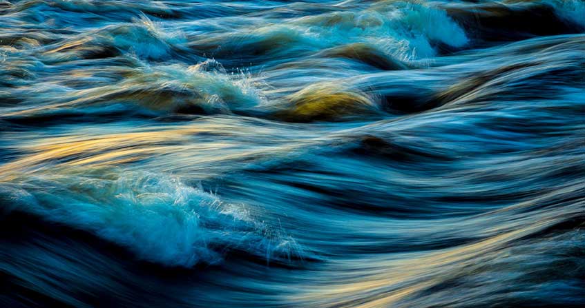
封面图片:辫状河的植被:意大利塔利亚门托Cover image. Vegetation of a braided stream: Tagliamento, Italy. [Source: © Photo J. Girel]
[1] Concept of permanent habitat renewal in the mosaic (Shifting Habitat Mosaïc = SHM); Stanford J.A., Lorang M.S. & Hauer F.R. (2005) The shifting habitat mosaic of river ecosystems. Verhandlungen der Internationalen Vereinigung für theoretische und Angewandte Limnologie, 29, 123-136.
[2] Hauer F.R., Locke H., Dreitz V.J., Hebblewhite M., Lowe W.H., Muhlfeld C.C., Nelson C.R., Proctor M.F. & Rood S.B. (2016) Gravel-bed river floodplains are the ecological nexus of glaciated mountain landscapes. Science Advances, 2(6), 1-13.
[3] Intermediate disturbance hypothesis; Wilkinson D.M. (1999) The Disturbing History of Intermediate Disturbance. Oikos 84(1), 145-147.
[4] River Continuum Concept (RRC); Vannote R.L., Minshall G.W. & Cummins K.W. (1980) The river continuum concept. Canadian Journal of Fisheries and Aquatic Sciences, 37, 130-137.
[5] Prunier P., Bonin L. & Frossard P.-A. (2013) Guide des espèces in: Interreg France-Suisse, Programme “GeniAlp” Génie végétal en rivière de montagne, 318 pages.
[6] Flood Pulse Concept (FPC); Junk W.J., Bayley P.B. & Sparks R.E. (1989) The flood-pulse concept in river-floodplain systems. Canadian Special Publication of Fisheries and Aquatic Sciences, 106, 110-127.
[7] Bravard J.-P. (2016) La longue durée des métamorphoses fluviales, in Bethemont J. & Bravard J.-P. « Pour saluer le Rhône », Ed. Libel, Lyon, 50-61
[8] Beechie T.J., Liermann M., Pollock M.M., Baker S. Davies J.R. (2006) Channel pattern and river-floodplain dynamics in forested mountain river systems. Geomorphology, 78(1-2):124-141.
[9] Girel J. (2016) La vallée de l’Isère entre Albertville et Grenoble: un paysage alluvial lié aux aménagements hydrauliques du XIXe siècle et à leurs impacts. in : P. Fournier & G. Massard-Guilbaud, (Dir), Aménagement et Environnement, Perspectives historiques, Collection “Histoire”, Presses Universitaires de Rennes, 149-161.
[10] Girel J., Garguet-Duport B. Pautou G. (1997) Present structure and construction processes of landscapes in Alpine floodplains. A case study: the Arc-Isère confluence (Savoie, France). Environmental Management, 21(6), 891-907.
[11] Girel J. (2010) Histoire de l’endiguement de l’Isère en Savoie : conséquences sur l’organisation du paysage et la biodiversité actuelle. Géocarrefour, 85(1), 2010, p. 41-54.
[12] 水力结构(大坝、堰、水力发电机组等)管理者必须为水道和生态系统的最低功能的强制保留最小水流量(以平均总流量的百分比表示)。
[13] Merritt D.M., Scott M.L., Leroy-Poff N., Auble G.T. & Lytle D.A. (2010) Theory, methods and tools for determining environmental flows for riparian vegetation: riparian vegetation-flow response guilds. Freshwater Biology, 55(1), 206-225.
[14] Salvador P.-G. (1991) La métamorphose des cours du Drac et de l’Isère à l’époque moderne dans la région grenobloise (Isère, France). Physio-Geo. (Paris), 22/23, 173-178.
[15] Ward J.V., Tockner K., Edwards P.J., Kollmann J., Bretschko G., Gurnell A., Petts G.E. & Rossaro B. (1999) A reference river system for the Alps: the “Fiume Tagliamento”. Regulated Rivers: Research & management, 15, 63-75.
[16] Girel J. (2011) Les communaux dans une vallée alpine au XIXe siècle: Impacts de l’endiguement sur le statut, la productivité et les usages des délaissés alluviaux (exemple de l’Isère dans la Combe de Savoie) in: C. Beck, J.-M. Derex & B. Sajaloli (eds), Usages et espaces communautaires dans les zones humides, Collection Journées d’études, GHZH, P. de Maisonneuve, Vincennes, 89-106. http://ghzh.free.fr/.
[17] Galat D.L., Fredrickson L.H., Humburg D.D., Bataille K.J., Bodie J.R., Dohrenwend J. et al (1998) Flooding to restore connectivity of regulated large-river wetlands. BioScience, 48, 721-733. 根据本文中提出的“串珠恢复概念”,连续扩大的冲积带(如项链中的珍珠)允许生物多样性发源地水文地貌和生态过程的正常运行。
[18] Till-Bottraud I., Poncet B.-N., Rioux D. & Girel J. (2010) Spatial structure and clonal distribution of genotypes in the rare Typha minima Hoppe (Typhaceae) along a river system. Botanica Helvetica, 120, 53-62.
环境百科全书由环境和能源百科全书协会出版 (www.a3e.fr),该协会与格勒诺布尔阿尔卑斯大学和格勒诺布尔INP有合同关系,并由法国科学院赞助。
引用这篇文章: GIREL Jacky (2024年12月28日), 高山冲积地貌与生物多样性, 环境百科全书,咨询于 2026年7月22日 [在线ISSN 2555-0950]网址: https://www.encyclopedie-environnement.org/zh/vivant-zh/alpine-alluvial-landscapes-and-biodiversity-2/.
环境百科全书中的文章是根据知识共享BY-NC-SA许可条款提供的,该许可授权复制的条件是:引用来源,不作商业使用,共享相同的初始条件,并且在每次重复使用或分发时复制知识共享BY-NC-SA许可声明。