Climate change and ancient civilizations
PDF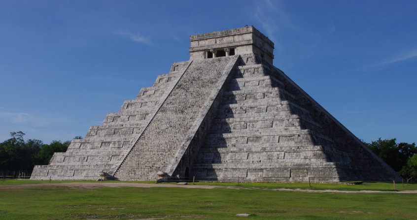
The history of the rise and fall of great past civilizations has often been closely linked to changing climatic conditions. This link is justified by the crucial importance at these times of regular agricultural production, which is very sensitive to climatic conditions and in particular to water availability. While archaeologists allow us, through their work, to better understand the history of these civilizations, paleoclimatology allows us to reconstruct some climatic variations in the past, and, among other things, to link changes in the water balance with environmental changes that may promote or degrade people’s lives in the past. Several examples illustrate this link between the history of human settlements and the climatic events that have marked the past millennia and raise questions. How could repeated episodes of drought have pushed Sumerian and Mayan civilizations to decline? What was the impact of the Little Ice Age on some populations in Europe and Asia?
1. The emergence of the first ancient cities favoured by the climate
The great ancient cities were often at the heart of the first civilizations. Placed on a world map, most of them are located in intertropical areas (Figure 1). This geographical distribution, which does not seem to be the result of chance, reveals a hypothesis: the location of these cities is due to the need for significant agricultural production to meet the needs of their inhabitants.
Endemic agriculture has been the basis of each of these civilizations:
- maize for pre-Columbian civilizations;
- rice for Asian peoples;
- wheat and barley for the first western and eastern cities.
Not only do these agricultures require a significant supply of water, but also a drier period. Tropical to subtropical climates offer the best hydrological conditions for such crops, with maximum rainfall in summer and a dry season in winter.
This maximum precipitation corresponds to the passage of the Intertropical Convergence Zone (ITCZ; Figure 1), a narrow climatic band that extends from east to west and migrates in latitude during the year (Read Jet-streams). This migration occurs between the tropics, i.e. between 20° N and 20° S, following approximately the maximum exposure. Winter is a dry season that limits the total water supply over the year and avoids flooding of crops. This alternation of highly contrasting hydrological conditions is less pronounced for temperature, although the latter could also play a decisive role on crops.

Only Mediterranean civilizations have developed in a much wider area, beyond the “fertile crescent”. Eastern peoples probably migrated from the Middle East following the upheavals of the first Mesopotamian civilizations; it was only after a first settlement in the north of the Arabian Peninsula that these peoples moved to an area particularly favourable to economic exchanges through navigation: the Mediterranean basin.
The location of the major centers of civilization, whether eastern, western, Asian or Amerindian, was, at least in part, determined by the favourable climatic conditions of these tropical latitudes. These conditions are also more locally found in Mediterranean and mountain climates, in particular. However, these climatic conditions have fluctuated on a regional scale, in particular in relation to the seasonal dynamics of the ITCZ. Paleoclimatic reconstructions allow us to specify these variations in different regions of the globe. Can we relate these variations to those of human populations? We will try here to show how a natural evolution of the climate has contributed to the establishment, growth, decline, or migration of human populations, with examples from different periods and continents.
2. Migration of climate zones over the last few millennia
The establishment and development of the civilizations in question took place several millennia ago; around 5,000 to 4,000 BC for the first Asian (first intensive rice cultivation) and Eastern (Mesopotamia) outbreaks, and 3,000 to 2,000 BC for the first Mesoamerican civilizations. These settlements therefore took place between 7,000 and 4,000 years ago BP, i.e. compared to today[2].
Technically, the dates indicated in this text refer to the Gregorian calendar, which uses as a reference the year ‘zero’, and the notations ‘before Christ’ (B.C.) and ‘Anno Domini’ (A.D.) for the years before and after the year zero respectively. These years can also be expressed in age, defined in relation to a current reference: the B.P. (‘Before Present’) rating uses the year 1950 AD as a reference, and the B2K (‘Before Year 2000’) rating the year 2000 AD. Thus, the year 4000 BC corresponds to ages of 5,950 years BP.
How can we reconstruct climatic variations over such past periods, and what do these reconstructions teach us? The scientists who reconstruct past climates from natural archives are paleoclimatologists. In tropical areas, these experts have highlighted migrations from the famous Intertropical Convergence Zone (ITCZ) over the last few millennia at different time scales. Thus, a general southward migration of the ITCZ has first been suggested over the past 6,000 years, ref. [2].
More recently, shorter-scale migrations (up to decades) have been specified, particularly during the so-called Early Ice Age period [3]. These climate changes are attributed to several factors, such as variations in sunstroke, and some large volcanic eruptions, amplified by feedback mechanisms between oceanic and atmospheric circulations [4]. This turning point, since 6,000 years B.P., corresponds more or less to the emergence of the first major centers of civilization in the regions exposed in the introduction, where men have found ideal climatic conditions for their development. In natural archives (such as lake or marine sediments, or cave stalagmites), records of the water balance indicate significant changes that must have affected the agricultural resources that ensure human survival. What evidence shows that these civilizations have been affected by these climate variations?
3. The Sumerian civilization

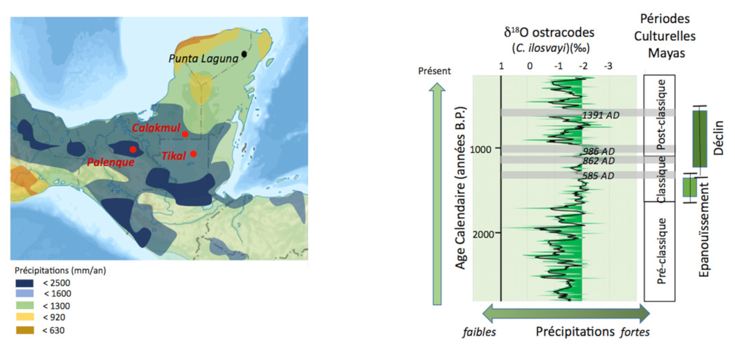
In order to feed the inhabitants of its cities, the State must ensure significant agricultural production: it relies on writing, which allows better management of resources such as crops, places, plants and animals’ accounting), but also on river exploitation, which guarantees the necessary water supply. These large rivers are fed by the Transcaucasian mountain range in the northern part of the Fertile Crescent, east of Anatolia (Figure 2a). Currently, these mountains receive between 0.6 and 1m of precipitation per year, which is sufficient to create large rivers (Figure 2a) [5]. Such climatic conditions, if they were identical more than 5,500 years ago, must have contributed to the proper development of agriculture, and therefore to the development of Sumerian civilization.
This civilization was at a turning point around 2,334 BC, with the influence of a new ruler, King Sargon, who brought together the various cities under the hegemony of a new capital, Akkad, to found the Akkadian empire. However, it seems that a major setback struck this empire a century after its emergence, that is, about 4,100 years ago. The term collapse of the Akkadian empire is often used to describe the loss of political influence of these large cities throughout the region, also corresponding to major armed conflicts and the exile of a significant part of the urban population. As often, it is not a real collapse since traces of occupation are still found in the region 300 years later.
What do the climate archives tell us about this period? Geological records show significant dust deposits, on the one hand in the area of the city of Tell Leilan in present-day Syria [6], and on the other hand in marine sediments in the Gulf of Oman, ref[5]. Marine deposits are dated at approximately 4,025 years B.P. with an uncertainty of 125 years (Figure 2b). These deposits indicate a rapid shift to much drier climatic conditions. Some writings report much more difficult agricultural conditions at that time, suggesting that significant climate change has had a drastic impact on agriculture, and consequently on the cohesion of the Akkadian empire. From a climatic point of view, the aridification of Mesopotamia would be linked to the cooling of surface waters in the North Atlantic, as such an atmospheric link has been demonstrated for the current climate. Paleoclimatic records show a drop in temperatures in the North Atlantic Ocean of about 1 to 2°C 4,100 years ago B.P. [7].
The climate cause is certainly not the only one to explain the fall of the Akkadian empire. Nevertheless, these significant climate changes have inevitably had impacts on agriculture and caused difficulties in meeting the needs of the population. These difficulties have undoubtedly contributed to conflicts between cities and a destabilization of political power.
This climatic event seems to have affected the entire tropical zone, probably in two phases, one around 4,200 years old and the other around 3,900 years B.P. [8], causing drought events in some geographical areas and heavy rainfall events in other regions. The magnitude of this climatic event is such that it is now used as a stratigraphic reference point for the definition of the most recent Holocene period sub-story, under the name of Meghalayan [9]
4. The Mayan civilization
- A preclassical period, which extends from 2000 BC to 250 AD;
- A classic period, during which this civilization reached its peak, between 250 and 900 AD;
- and finally a post-classical period, where large cities have declined and emptied themselves of their inhabitants, and where small communities have regrouped in scattered villages. This weakening leaves the field open for the arrival of new peoples from the north, such as the Toltecs, who are bringing new cities to the north of the peninsula.
During the pre-Classical period, the Mayans settled in small villages and began to modify their environment, clearing the jungle in order to establish the first crops, especially corn. This development is, as for the Sumerian and Akkadian civilizations, supported by a precise writing system and calendar, making it possible to manage agricultural holdings as well as possible.
The establishment of a powerful political and religious power, centralized around a “king-divine”, sees the emergence of several city-states, such as Tikal (Figure 4), Calakmul or Palenque, which will try to extend their perimeter of domination over different areas of the peninsula (Figure 3a). A subtle interplay of wars and alliances then began between these cities, leading to the construction of ever more monumental temples and pyramids, around which more and more inhabitants came to find protection [11]. This increase in urban density leads to increased exploitation of crop areas. It seems obvious that accelerated deforestation occurred during the classical period.

In a context very different from the previous example, and if climate variations are certainly not the only causes of the destabilization of a civilization, the temporal conjunction of the two events (climate change and cultural upheavals) has probably accelerated the process of radical changes in the functioning of a human society, calling into question its sustainability.
5. Impacts of the Little Ice Age
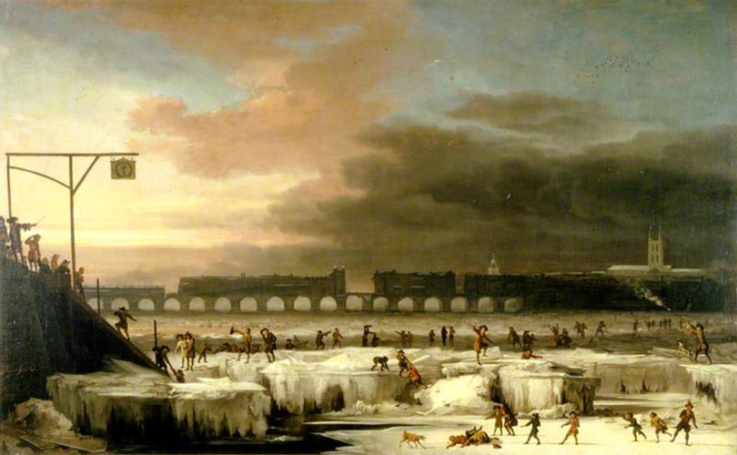
The Little Ice Age (Figure 6) is a period that extends approximately from the 14th to the 19th century, during which the lower activity of the sun, but also the occurrence of strong volcanic eruptions, has affected the global climate in a sustainable way, including through cooling [17]. This decline in solar activity, in successive waves in the 14th, 15th, 17th and 18th centuries, to which volcanic eruptions were added, caused a significant drop in temperatures in the North Atlantic Ocean, but also modified the general atmospheric circulation, with a southward migration of the ITCZ described by several climate archives [18].
5.1. Cooler conditions in Greenland

During the Lesser Ice Age, a progressive advance of glaciers, associated with a drop in atmospheric and ocean temperatures, has been documented in environmental records, including ice sheets and marine sediments off Iceland and Greenland. These changes have forced the Vikings into the dilemma of either adapting, by changing their lifestyles and diets, or setting out on the open sea to find more lenient living conditions. After trying the first option by turning to an economy based on fishing and marine resources [19], they definitively fled these lands that had become hostile to return to Scandinavia or colonize the northern coasts of the American continent. The last Viking burials found on Greenland land are dated around 1430 A.D., ref [18].
5.2. Dryer conditions in Southeast Asia
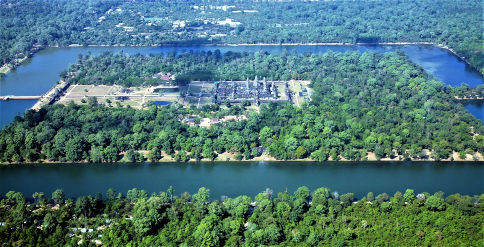
In a completely different context, in the countries of South-East Asia, the Khmer civilization has spread over Cambodian territory and has built a first-rate architectural complex on the Angkor site. The first buildings date back to the 9th century, and the expansion of the site accelerated with the construction of Angkor Wat (Figure 8) and Angkor Thom in the 12th century, thanks to climate stability. The regular alternation of dry and wet seasons allowed sufficient rainfall to be provided, if stored, to feed crops and feed the ever-growing population. As can be observed for other civilizations (see the Mayas in Part 4), the hydraulic engineering work developed at that time is remarkable: several retention basins of more than 50 km2 were associated with a network of canals and dikes extending over several hundred kilometres.
At its peak, the Khmer empire spread over a large part of the countries of Southeast Asia until the 14th century. Around the 15th century, historians pointed to a drastic reduction in this power, until the Angkor temples were abandoned. This period of decline corresponds approximately to the Early Ice Age period.
It can be seen that climate changes in the Early Ice Age have had different expressions depending on the geographical areas: lower temperatures in countries around the North Atlantic Ocean, lower precipitation in countries in South-East Asia. In the Pacific, a marked advance of glaciers in the valleys of New Zealand [22], heavy rainfall on the island of Tahiti [23] and on the Galapagos archipelago [24] have been reported. The Little Ice Age has therefore had contrasting climatic impacts in different parts of the world.
6. Messages to remember
- Adaptation to the environment has often been the key to sedentarization. This adaptation is all the easier when the environment is favourable.
- The development of several large cities through the ages, ancient or more recent, is closely linked to the availability and management of natural resources, and in particular fresh water. For tropical regions, this availability results from the seasonal balancing of the maximum precipitation zone (ITCZ), which supplies these regions with water stored from one year to the next.
- Climate records show that the extent of this balancing has varied over time, with significant hydrological impacts. The hydraulic engineering of the peoples has made it possible to build reservoirs, retention basins or irrigation canals: these installations have proved extremely effective in dealing with short or moderate climatic hazards, as has been shown for the Mayan cities of Palenque, Tikal, and the Khmer city of Angkor.
- When climate change has proved too great, these ingenious adaptations have not been sufficient. Most people then migrated to find new conditions elsewhere that were favourable to their development.
- The climate changes expected over the next century will not be homogeneous across the globe. Each region can expect more or less significant changes in temperature or water balance, as well as impacts related to rising sea levels on coastal regions and deltas. People will then have several possibilities: adaptation, migration or disappearance.
For developed countries, some agricultural adaptations are already underway or at least under consideration, for example the adaptation of grape varieties to wine-growing regions. On the other hand, the costs of these adaptations may not be borne by all. Other sensible savings policies could then emerge. The peoples who preceded us have put in place adaptation strategies, sometimes successful, sometimes doomed to failure. If a certain resilience can undoubtedly be achieved on a regional or even national scale, what about the global level?
Notes and references
Cover image. Illustration of the Mayan civilization at the height of its splendour. Pyramid of Kukulkán, also known as El Castillo, Mayan archaeological site of Chichén Itzá, Yucatan, Mexico. [Source: © B. Malaizé, 2010]
[1] BOQUEHO V. Les civilisations à l’épreuve du climat, Dunod, “Quai des sciences”, 2012, 192 p.
[2] Wanner H., Beer J., Bütikofer J., Crowley T.J., Cubasch U., Flückiger J., Goosse H., Grosjean M., Joos F., Kaplan J. O., Küttel M., Müller S. A., Prentice I. C., Solomina O., Stocker T. F., Tarasov P., Wagner M. and Widmann (2008), Mid-to Late Holocene climate change: an overview, Quaternary Science Reviews, 27(19-20), 1791-1828. doi:10.1016/j.quasi-cirev.2008.06.013.
[3] Lechleitner F.A., Breitenbach S. F.M., Rehfeld K., Ridley H. R., Asmerom Y., Prufer K.M., Marwan N., Goswami B., Kennett D.J., Aquino V.V., Polyak V., Haug G.H, Eglinton T. and Baldini J. U.L. (2017) Tropical rainfall over the last two millennia: evidence for a low-latitude hydrologic seesaw, Nature Comm., doi:10.103B/srep45809.
[4] Schurer A. P., Tett S.B.F., Hegerl G.C. (2014). Small influence of solar variability on climate over the past millennium. Nature Geosciences, 7: 104-108.doi:10.1038/ngeo2040.
[5] Cullen H.M., deMenocal P.B., Hemming S., Hemming G., Brown F.H., Guilderson T. and Sirocko F. (2000), Geology, vol 28, n4, 379-382.
[6] Weiss H., Courty M-A., Wetterstrom W., Guichard F., Senior L., Meadow R. and Curnow A. (1993), vol 261, pp 995-1004, doi: 10.1126/science.261.5124.995.
[7] deMenocal P. B. (2001), Cultural responses to climate change during the Late Holocene, Science, 292, 667, doi: 10.116/science.1059827.
[8] Railsback L. B., Liang F., Brook G. A., Voarintsoa N. R. G., Sletten H. R., Marais E., Hardt B., Cheng H. and Edwards R. L. (2018), The timing, two-pluse nature, and variable climatic expression of the 4.2 ka event : A review and new high resolution stalagmite data from Namibia, Quat. Sci. Rev., 186, 78-90.
[9] Event recently ratified by the International Commission on Stratigraphy (ISQS, 2018).
[10] Curtis J.H., Hodell D. A. and Brenner M. (1996), Climate variability on the Yucatan peninsula (Mexico) during the past 3500 years, and implications for Maya Cultural evolution, Quat. Res, 46, 37-47.
[11] Martin S. and Gruβe N., Chronicle of the Maya kings and Queens, Thames and Hudson, 2005, 240p.
[12] Curtis J.H., Hodell D. A. and Brenner M. (1996), Climate variability on the Yucatan peninsula (Mexico) during the past 3500 years, and implications for Maya Cultural evolution, Quat. Res, 46, 37-47.
[13] Hodell D. A., Brenner M., Curtis J. H., Medina-Gonzalez, Ildefonso-Chan Can E., Albomaz-Pat A. and Guilderson T. (2005), Climate change on the Yucatan peninsula during the Little Ice Age, Quat Res., 63, 109-121. Doi:10.1016/J.yqres.2004.11.004.
[14] Rosenmeier M. F., Hodell D. A., Brenner M. and Curtis J. H. (2002), A 4000 year lacustrine record of environmental change in the Southern Maya Lowlands, Peten, Guatemala, Quat. Res. 57, 183-190. doi:10.1006/qres.2001.2305.
[15] Fleury S., B. Malaizé, J. Giraudeau, D. Galop, V. Bout-Roumazeilles, P. Martinez, K. Charlier, P. Carbonel and C. Arnauld (2014) “Impacts of Maya land use on Laguna Tuspan watershed (Peten, Guatemala) as seen through clay and ostracode analysis”. Jr Archaeo Sc., 49, 372-382.
[16] Haug G.H., Günther D., Peterson L.C., Sigman D.M., Hughen K. A. and Aeschlimann B. (2003), Climate and the collapse of the Maya civilization, Science, vol. 299, 1731-1735.
[17] Schurer A. P., Tett S.B.F., Hegerl G.C. (2014). Small influence of solar variability on climate over the past millennium. Nature Geosciences, 7: 104-108.doi:10.1038/ngeo2040.
[18] Lechleitner F.A., Breitenbach S. F.M., Rehfeld K., Ridley H. R., Asmerom Y., Prufer K.M., Marwan N., Goswami B., Kennett D.J., Aquino V.V., Polyak V., Haug G.H, Eglinton T. and Baldini J. U.L. (2017) Tropical rainfall over the last two millennia: evidence for a low-latitude hydrologic seesaw, Nature Comm., doi:10.103B/srep45809.
[19] Arneborg J., Heinemeier J., Lynnerup N., Nielsen H., Rud N. and Sveinbjörnsdottir A.E., (1999), Change in the diet of the Greenland vikings determined from stable carbon isotope analysis and 14C dating of their bones, Radiocarbon, Vol 41, 157-168.
[20] Zhang P., Cheng H., Edwards R. L., Chen F., Wang Y., Yang X., Liu M., Tan M., Wang X., Liu J., An C., Dai Z., Zhou J., Zhang D., Jia J., Jin L. and Johnson K. R., (2008), A test of climate, sun and culture relationship from an 1810-year Chinese cave record, Science, vol 322, 940-942, doi: 10.1126/science.1163965
[21] Day M.B., Hodell D. A., Brenner M., Chapman H.J., Curtis J. H., Kenney W. F., Kolata A. L. and Peterson L., (2011), Paleoenvironmental history of the West Baray, Angkor, Cambodia, PNAS, vol 109, 1046-1051, doi: 10.1073/pnas.1111282109.
[22] Schaefer J.M., Denton G. H., Kaplan M., Putnam A., Finkel R.C., Barrell D. J. A., Andersen B. G., Schwartz R., Mackintosh A., Chinn T and Schlüchter C., (2009), Hign frequency Holocene Glacier fluctuations in New Zealand differ from the Northern Signature, Science, vol 324, 622-625, doi:10/1126/science.1169312.
[23] Orliac M. (1986), A la recherche des anciens polynésiens, Tahiti et Moorea, in’Encyclopedie de la Polynésie, Vol 4, p82-83, ed C. Glizal/ les éditions de l’Alizé.
[24] Nelson D. B. and Sachs J. P. (2016), Galapagos hydroclimate of the common Era from paired microalgal and mangrove biomarker 2H/1H values, PNAS, vol 113 3476-3481, doi: 10.1073/pnas.1516271113.
The Encyclopedia of the Environment by the Association des Encyclopédies de l'Environnement et de l'Énergie (www.a3e.fr), contractually linked to the University of Grenoble Alpes and Grenoble INP, and sponsored by the French Academy of Sciences.
To cite this article: MALAIZE Bruno (January 5, 2025), Climate change and ancient civilizations, Encyclopedia of the Environment, Accessed July 23, 2026 [online ISSN 2555-0950] url : https://www.encyclopedie-environnement.org/en/climate/climate-change-and-ancient-civilizations-2/.
The articles in the Encyclopedia of the Environment are made available under the terms of the Creative Commons BY-NC-SA license, which authorizes reproduction subject to: citing the source, not making commercial use of them, sharing identical initial conditions, reproducing at each reuse or distribution the mention of this Creative Commons BY-NC-SA license.