Ecological networks: how to reconcile biodiversity conservation and land-use planning?
PDF
In the face of accelerating environmental degradation, biodiversity conservation can no longer be reduced to the simple protection of natural areas. Environmental policies are now turning to a dynamic and integrated vision of conservation, taking into account the movements of animal species and the diversity of species and human activities that share the same territory. This is how “ecological networks” came into being, enabling species to move between protected areas, even in fragmented landscapes. Despite the scientific and operational challenges they raise, can ecological networks be one of the solutions to halting the decline in biodiversity?
1. Ecological networks: a new approach to conservation
Human activities are contributing to an increasingly rapid and far-reaching transformation of our environment, reflected in climate change and a massive decline in biodiversity. In an attempt to halt this decline, environmental policies have long focused on setting aside natural areas that are home to remarkable species and environments. Improved scientific knowledge of ecosystem dynamics, coupled with the realization that protected areas were incapable of slowing the decline in biodiversity, led to a major paradigm shift in the 1990s. From a static vision, conservation approaches evolved towards a more dynamic and integrated vision, taking into account biological flows between habitats, the diversity of species – even the most “ordinary” – and the diversity of human activities sharing the same territory.
These new approaches are based on the identification of “ecological networks”, made up of areas protected to varying degrees and corridors enabling species to move between protected areas, particularly in highly fragmented landscapes. This change in approach raises both scientific and operational issues, particularly in terms of assessing connectivity, characterizing ecological networks and incorporating them into planning documents. Despite numerous studies, ecological networks, connectivity and landscape fragmentation are still the subject of much debate, given the complexity of the processes involved, the overlapping scales involved and the fragmented nature of our knowledge.
2. Fragmentation and connectivity: what are we talking about?
Research into landscape fragmentation and connectivity has proliferated over the last fifteen years, significantly improving our knowledge of the interactions between landscape structures and the flow of organisms, while at the same time generating numerous debates on their effects on biodiversity. These debates – and even contradictions – have repercussions in the operational world when it comes to the various strategies to be implemented to conserve biodiversity.
2.1. Habitat fragmentation or loss of habitat surface area?
Habitat fragmentation is a spatial process that transforms a continuous area of habitat into several fragments of varying size. This fragmentation is often accompanied by a reduction in the total amount of habitat in the landscape (Figure 1, center) [2], although this is not systematic (Figure 1, bottom). The two processes (fragmentation and loss of surface area) are therefore often confused, leading to scientific debates about the positive or negative effects of fragmentation on species [3].
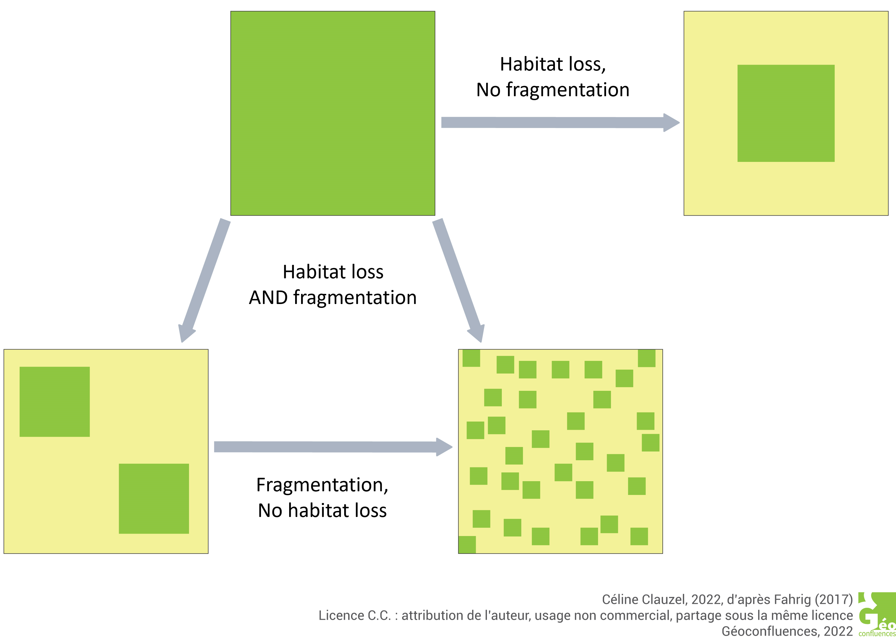
Habitat loss and fragmentation are therefore not synonymous, and can have different implications for conservation. If a species’ decline is linked to the fragmentation of its habitats, the creation of corridors connecting fragments can help reduce their isolation. On the other hand, if the decline is linked to overall habitat loss, this strategy will have little effect, and restoration of habitats of sufficient size and quality would in this case be more appropriate.
2.2. Connectivity, a poorly defined landscape property
Connectivity can be assessed in two ways, depending on the degree of complexity we wish to approach. The simplest approach is to consider only the structure of the landscape, i.e. the way in which the various landscape elements are arranged (“structural” connectivity). It is based on the assumption that if two habitats are linked by a corridor of the same nature, organisms – whatever they may be – can reach one habitat from another. However, this assumption is not always true, and depends on the organisms’ ability to move (distance, environments crossed). A kilometer-long woodland corridor, for example, may be functional for forest mammals, but probably not for certain insect species that can only cover a few hundred meters. To go beyond this structural vision, another approach is to integrate the behaviour of organisms in addition to the spatial arrangement of landscape elements (“functional” connectivity). Taking into account the movement capacities of species in response to the composition and configuration of the landscape enables a more precise analysis, but requires more biological knowledge of the species.
These two approaches to connectivity make it difficult to develop a single assessment method. A landscape is not intrinsically connected or not; its degree of connectivity depends on the species studied and the ecological process at the origin of the movement (foraging, seasonal migration, dispersal). The absence of a common definition in the scientific sphere probably explains the similar situation that exists in the operational world. The terms used are numerous (habitat connectivity, landscape connectivity, ecological connectivity, spatial connectivity, biological connectivity, etc.) and often mistakenly used interchangeably. Connectivity is also sometimes confused with the notion of corridor, continuity or ecological continuum (see Focus Continuity, continuum, corridor, connectivity). The absence of a common, shared definition, whether at international or national level, has had contrasting effects on the implementation of environmental policies dedicated to connectivity. For example, the fact that the term is not enshrined in law prevents the implementation of genuine legal obligations to maintain and restore connectivity [6]. Nevertheless, this “vagueness” also allows stakeholders a certain amount of leeway to adapt to the specificities of their territories in identifying “their” ecological continuities.
3. From site conservation to networking natural habitats
Research in ecology and conservation biology in particular has highlighted the importance of preserving functional connections between habitats to enable organisms to move around. The paradigm of site conservation based on a balance of nature and the priority given to exceptional biodiversity has thus been progressively called into question.
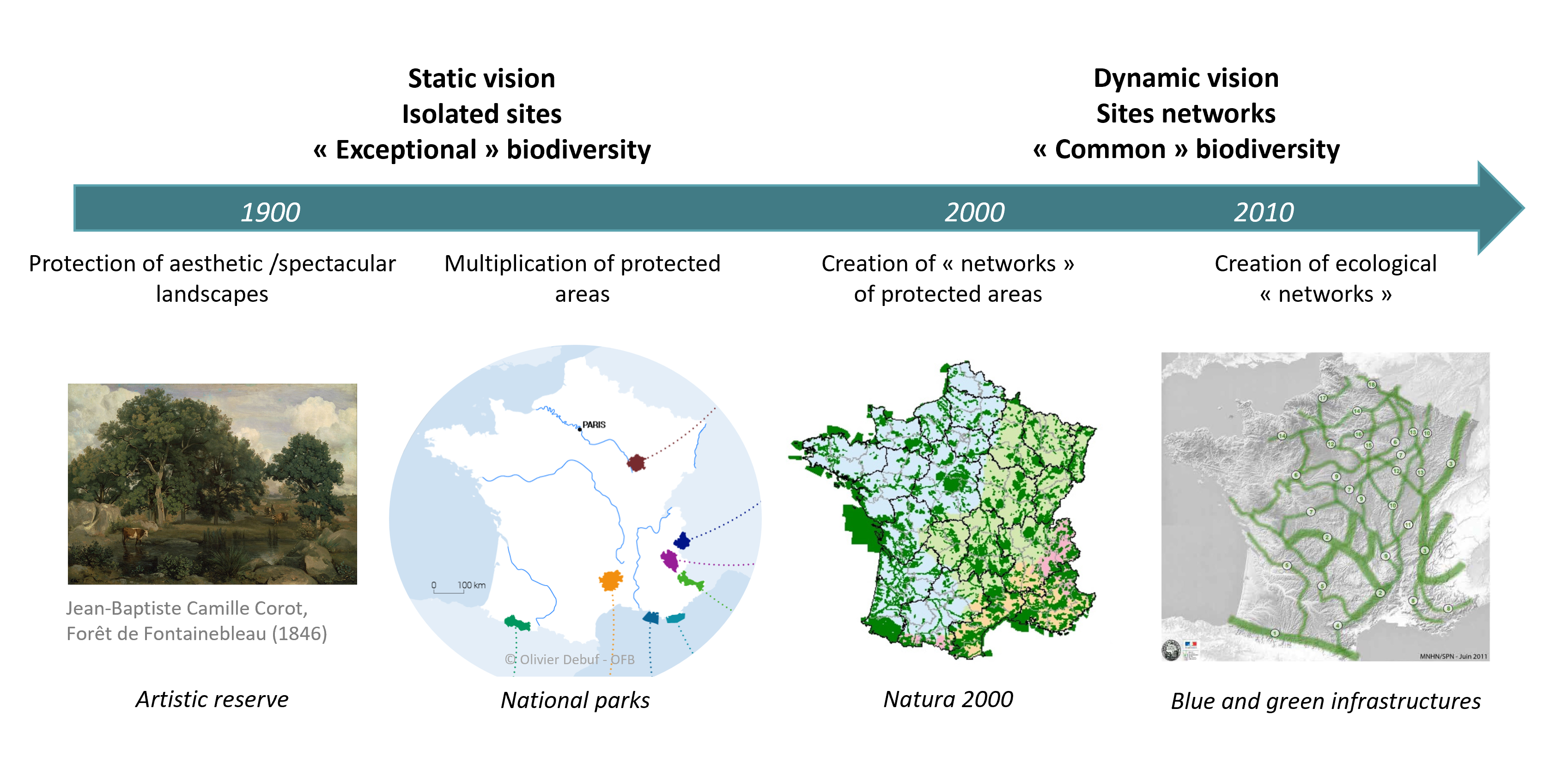
3.1. The networking of protected areas, a new conservation paradigm
Following in the footsteps of the first nature reserves and national parks of the late 19th century, conservation strategies have long been based on the same principle: the protection of particular (or “remarkable”) species and habitats on a spatially circumscribed site. Improved scientific knowledge of ecosystem dynamics, coupled with the failure of protected areas to halt the decline in biodiversity, led to a major paradigm shift in the 1990s towards an integrative, dynamic approach to conservation, taking into account both habitats and the flows between them (Figure 3).
Following the Rio Summit in 1992, the European Union laid the foundations for a pan-European ecological network, designed to ensure the conservation of ecosystems and habitats of European importance, and to be implemented at national and regional levels. At the same time, the European Union is proposing the creation of a network of protected areas, Natura 2000, designed to ensure the long-term survival of species and the maintenance of habitats representative of European biodiversity. Once again, Natura 2000 focuses on natural and semi-natural environments of great heritage value, due to the exceptional flora and fauna they contain. Nevertheless, member states of the network are required to “encourage the management of particular landscape elements” in order to “improve their ecological coherence” (article 10). Landscape elements deemed important are those “essential to the migration, geographical distribution and genetic exchange of species”. Article 10, which addresses connectivity issues without naming them, is merely a recommendation, and Natura 2000 does not specifically concern the corridors that could connect the sites. As a result, the degree of connectivity between Natura 2000 sites remains low, as the networking objective is more concerned with information flows for their management.
The latest UN Conference on Biodiversity (COP15 postponed to April 2022 due to the pandemic) raised the Aichi target to at least 30% of land and sea to be protected by functional ecological networks by 2030 (Target 3) and restoration of at least 20% of degraded ecosystems by ensuring connectivity between them (Target 2). The European Union’s new biodiversity strategy for 2030 sets similar targets and stresses the need for a coherent and resilient trans-European natural network in which ecological corridors are essential, but without formulating a precise connectivity objective.
3.2. Ecological networks, an ecological object suited to territorial planning
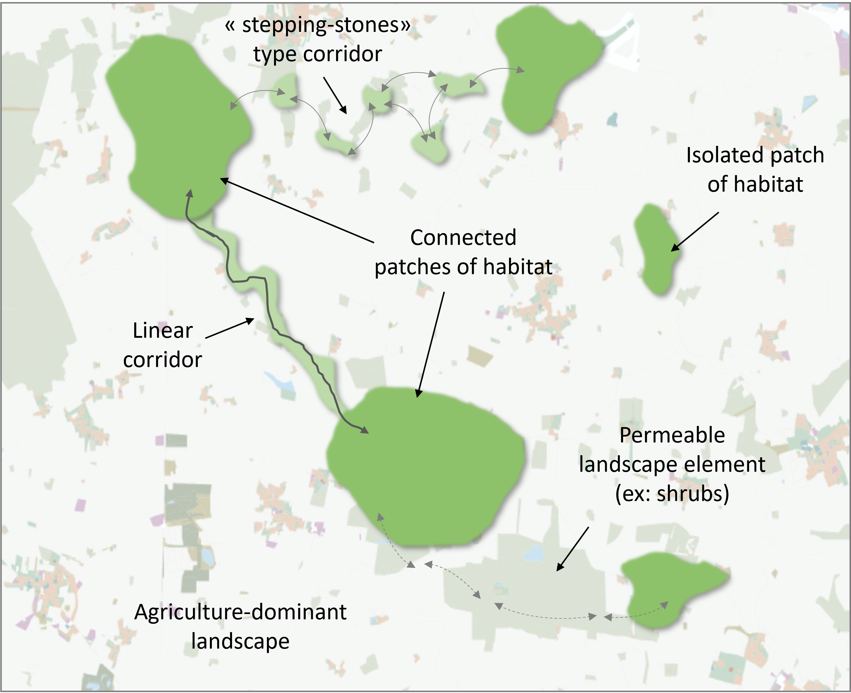
New ways of thinking about conservation on a territorial scale are based on the recognition of ecological networks, made up of protected areas of varying degrees and corridors enabling species to move between their habitats. An ecological network thus refers to the functional space within which a species can carry out its entire life cycle. It includes both the different habitats a species may occupy during its lifetime and the environments that facilitate its daily, annual or intergenerational movements. In a predominantly agricultural landscape, for example, a “forest” ecological network would be created (Figure 5):
- patches of habitat of a different nature to the dominant landscape (copses in an agricultural landscape), compact in shape and divided into several separate fragments. These patches provide habitats for forest-related species;
- corridors similar in nature to habitat patches, but linear in form, too narrow to constitute a habitat. They connect habitat patches together, providing a means of movement for species.
An ecological network is also a planning device for biodiversity conservation. This approach has won the support and appropriation of a wide range of stakeholders, thanks in particular to a definition that is sufficiently vague to be adapted to the specific characteristics of each territory [9]. Planning conservation through ecological networks allows a certain flexibility, in the sense that changes in the landscape do not necessarily lead to an irremediable loss of connectivity. The functionality of an ecological network is in fact linked to several parameters (total habitat area, habitat quality, network density, permeability of landscape elements, etc.) and deterioration in one parameter can, in some cases, be partially offset by improvement in another. Finally, systems based on ecological networks have a highly didactic dimension. Their relatively simple cartographic representation makes them easy to read and understand for non-specialists. The “ecological network” object thus becomes a tool facilitating communication and consultation between stakeholders, by linking biodiversity conservation and territorial planning issues.
4. Moving from theory to practice: integrating connectivity into territorial planning
The implementation of functional ecological networks aims to maintain the habitats and movement capacities of all ordinary and remarkable species on a territory. However, it is impossible to acquire exhaustive and precise knowledge of the factors influencing species’ habitats and movements. Despite this, managers and project owners must integrate these parameters into their development strategies. How, then, can biodiversity conservation actions be implemented when only partial knowledge of the processes at work is available?
4.1. Ecological networks at different scales
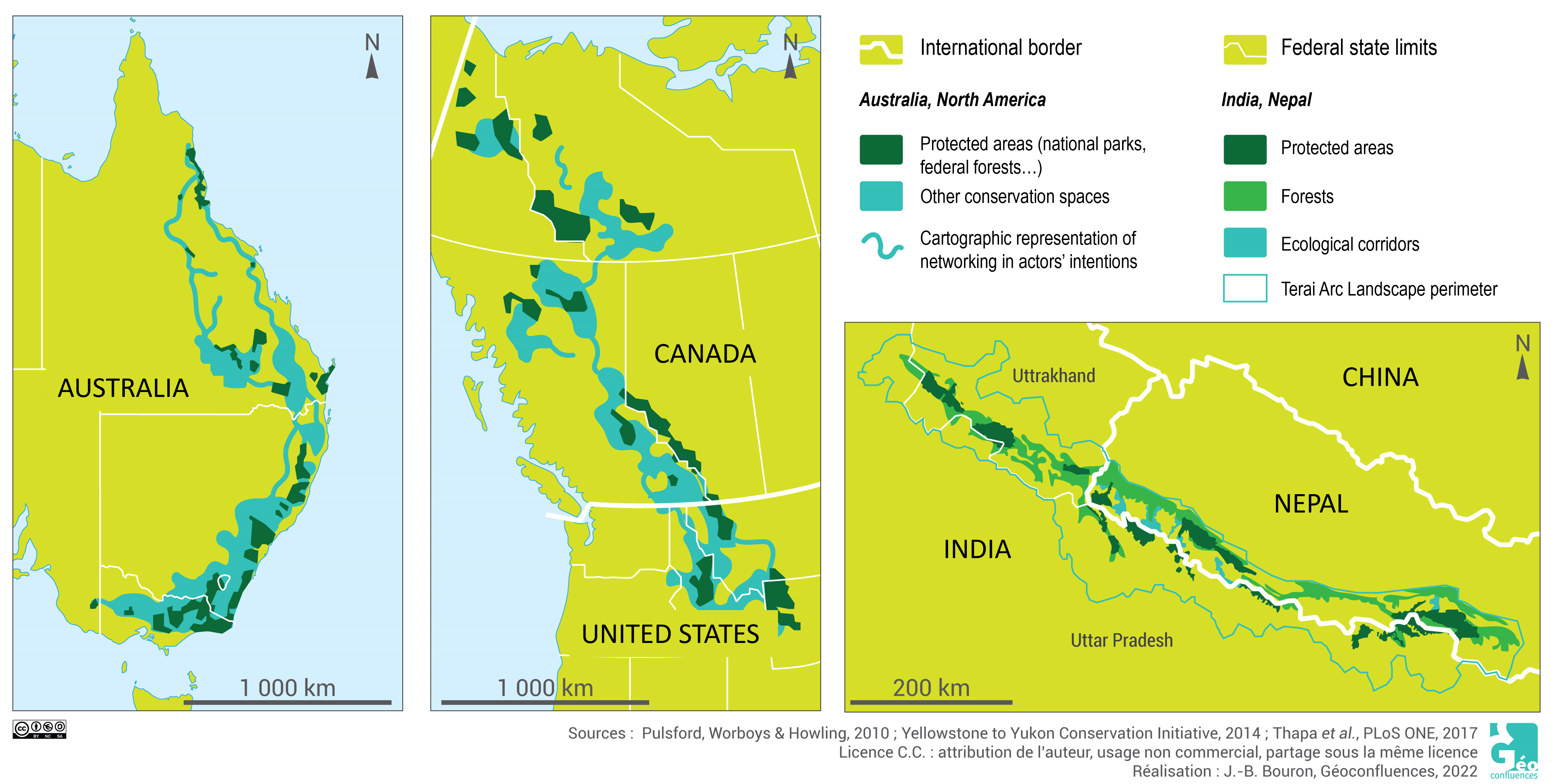
Ecological networks cover a wide range of spatial and temporal scales, depending on the processes involved. Transnational schemes generally aim to preserve the movement capacities of highly mobile species, often considered as emblematic species known worldwide (“flagship species“). The Terai Arc Landscape between Nepal and India, for example, aims to link 14 forest protected areas over a distance of 810 km, home to the Bengal tiger, the Indian rhinoceros and the Asian elephant, among others (document 6). Between the USA and Canada, the Yellowstone to Yukon Conservation Initiative aims to maintain and restore 3,200 km of varied natural habitats and corridors for grizzly bears, caribou and lynx. In southern Africa, Transfrontier Parks are intended to enable the free movement of wild animals regardless of borders, thanks to coordinated management between the countries concerned [10].
As in other countries, the TVB is a complementary tool for the conservation of biodiversity, which must be coordinated with other systems already in place (national parks, nature reserves, biotope protection orders, Natura 2000, regional nature parks, etc.). While common criteria and issues have been established to guarantee a degree of national consistency, the law does not set out a mandatory methodological framework for identifying and characterizing the TVB within the regional ecological coherence schemes (SRCE). Each region was thus free to define its own methodology, depending on the availability of data, tools and skills, the emphasis placed on consultation and the issues at stake in its territory. The regional TVB is then applied on a departmental scale through sensitive natural areas, agricultural land use planning or water management policies, and on a local scale in urban planning documents [13].
4.2. Progress to be made in taking functional connectivity into account
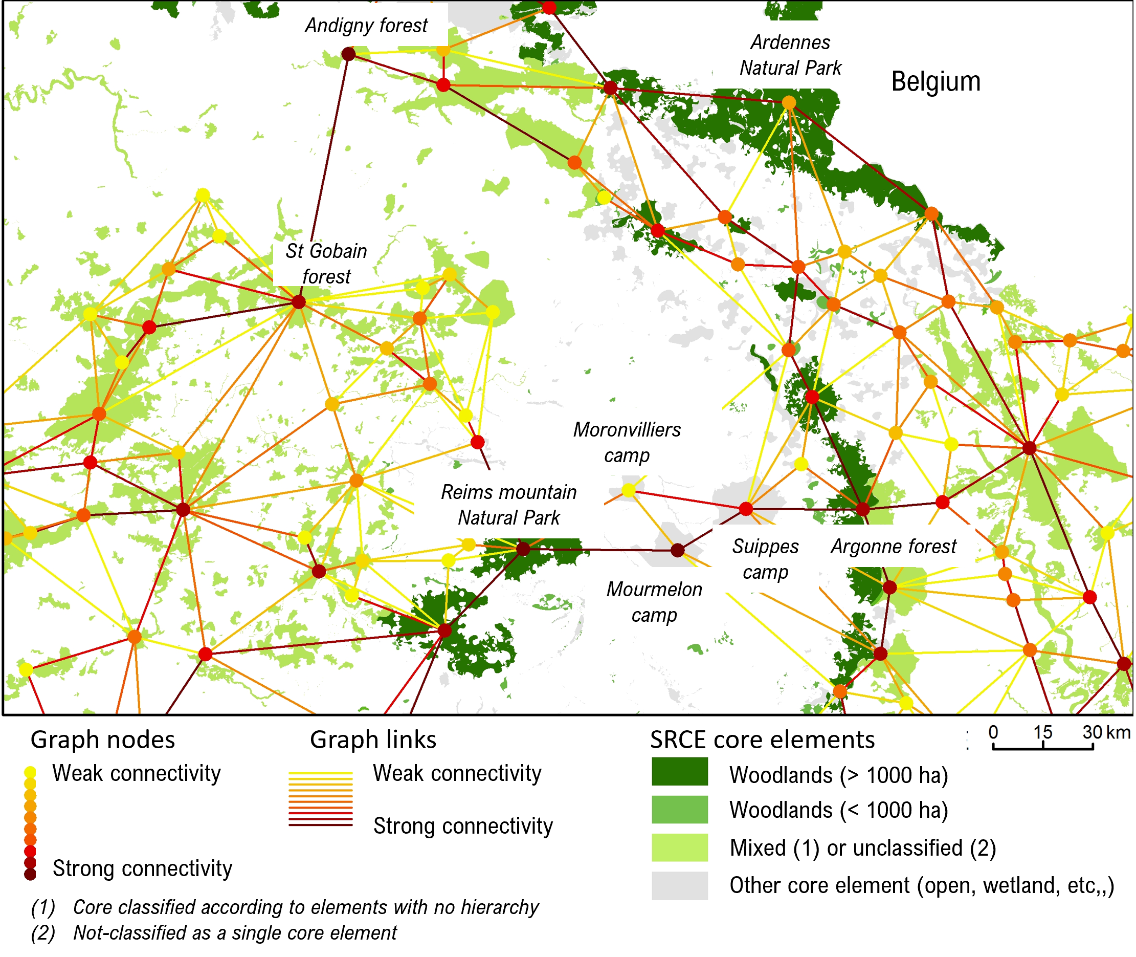
The use of generic data and a standardized method makes it possible to identify reservoirs and corridors in a homogeneous way across the whole territory, and to overcome regional administrative boundaries. The method also provides information on the ability of reservoirs and corridors to maintain the functionality of the ecological network on a global scale. For example, Figure 7 highlights the major role of the Montagne de Reims, Saint-Gobain and Argonne forests (nodes in the brown graph), which are connected to numerous other patches of forest habitat. It also reveals fragile connections between the two large forest complexes separated by agricultural environments. Only two forest corridors are potentially functional for wildlife: one continuous but very narrow along the Oise valley between the St Gobain forest and the Forêt d’Andigny, the other discontinuous between the PNR de la Montagne de Reims and the Argonne forest, based on the presence of copses in the Mourmelon and Suippes military camps.
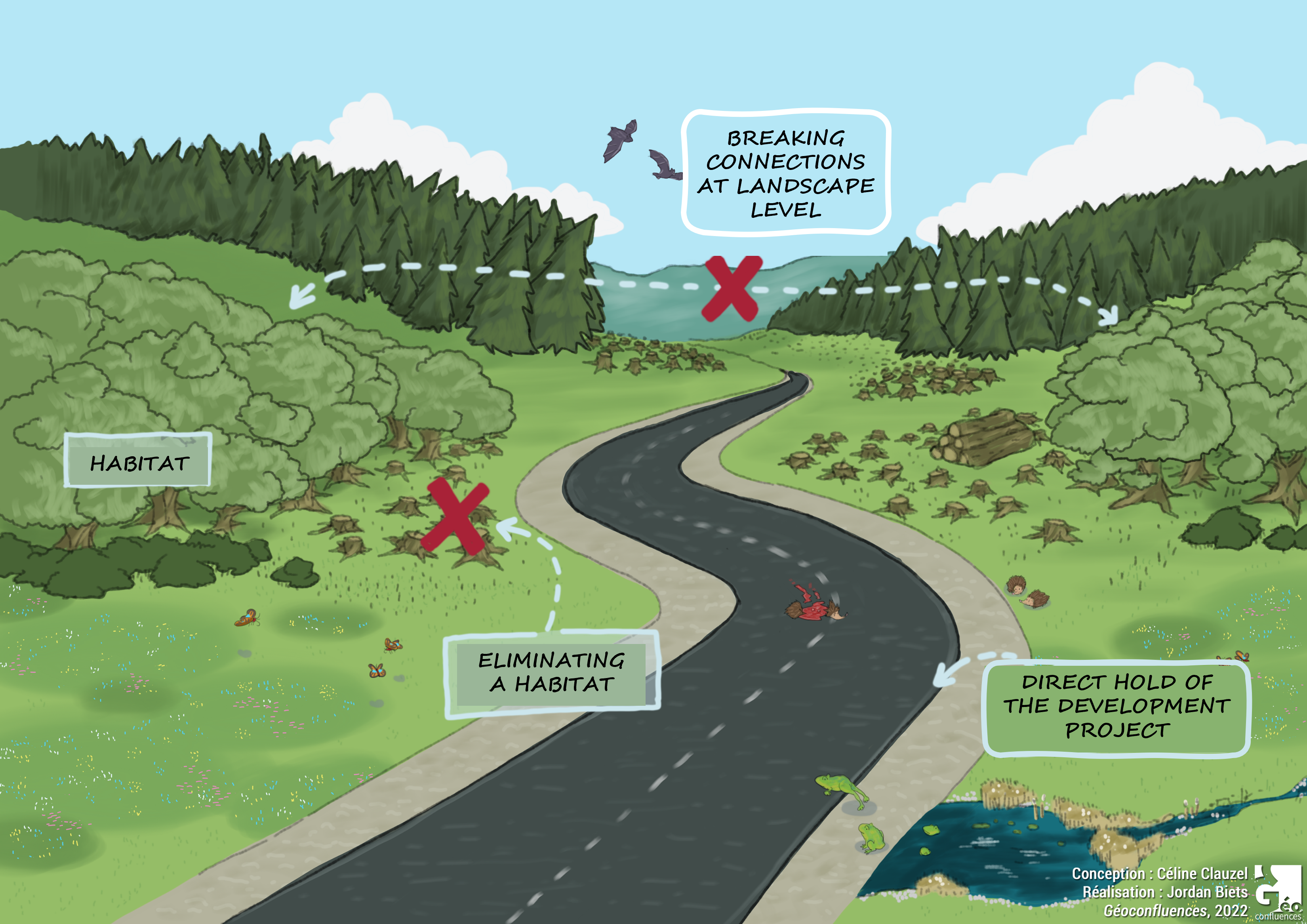
The results can thus help to prioritize the elements of the TVB, an issue that is currently underdeveloped in SRCEs. Modelling can also be used to meet another objective of the TVB, that of locating, prioritizing and mitigating obstacles to ecological continuity. By superimposing the modeled ecological network and the obstacles identified in the TVB (linear transport infrastructures, for example), it is possible to locate sectors at high risk of a breakdown in connectivity, which could be the subject of mitigation measures (wildlife crossings, for example) [17].
With this in mind, recent work on the spatial modelling of ecological networks provides methods and tools for integrating functional connectivity into land-use planning, by assessing damage in terms of the “quantity of habitat attainable at landscape level”, a connectivity indicator that takes into account both the surface area and quality of habitat patches, as well as their degree of connection. This makes it possible to identify project locations that minimize the impact on functional connectivity, and areas where mitigation and compensation measures can be implemented to restore and enhance connectivity [20].
5. Messages to remember
- Many countries have implemented various forms of ecological network legislation to preserve and enhance connectivity.
- While the importance of connectivity for biodiversity is recognized – as evidenced by the IUCN’s 2020 publication [21]– approaches to measuring, maintaining and enhancing connectivity are still considered to be “scattered and inconsistent”.
- A better formalization of the concepts of ecological network, connectivity and fragmentation, each of which covers a variety of realities depending on the players involved, is deemed essential for implementing effective biodiversity conservation.
—
The french version of this article by Céline Clauzel was originally published in June 2022 by Géoconfluences, under Creative Commons license, « Les réseaux écologiques, une stratégie de conservation pour concilier fonctionnalités écologiques et aménagement du territoire. [1]
Notes and references
Cover image. Example of a wooded landscape (Source: Thuringia, Germany [Photo © Tobias Nordhausen, 2018, license (CC BY-NC-SA 2.0) via Flickr]
[1] Céline Clauzel, ” « Les réseaux écologiques, une stratégie de conservation pour concilier fonctionnalités écologiques et aménagement du territoire.”, Géoconfluences, June 2022.
[2] Fahrig, L. (2017). “Ecological responses to habitat fragmentation per se”. Annual Review of Ecology, Evolution, and Systematics, 48, 1-23.
[3] See for example the debate:” Is habitat fragmentation good for biodiversity?” by Fletcher, R. J., Didham, R. K., Banks-Leite, C., Barlow, J., Ewers, R. M., Rosindell, J., Holt, R. D., Gonzalez, A., Pardini, R., Damschen, E. I., Melo, F. P. L., Ries, L., Prevedello, J. A., Tscharntke, T., Laurance, W. F., Lovejoy, T. and Haddad, N. M. (2018). “Is habitat fragmentation good for biodiversity?” Biological Conservation, 226, 9-15. and the response “Is habitat fragmentation bad for biodiversity?” by Fahrig, L., Arroyo-Rodríguez, V., Bennett, J. R., Boucher-Lalonde, V., Cazetta, E., Currie, D. J., Eigenbrod, F., Ford, A. T., Harrison, S. P. and Jaeger, J. A. (2019). “Is habitat fragmentation bad for biodiversity?” Biological Conservation, 230, 179-186.
[4] L’Hostis Alain, “Connectivité”, Hypergéo, 2007.
[5] Taylor, P. D., Fahrig, L., Henein, K. and Merriam, G. (1993). “Connectivity Is a Vital Element of Landscape Structure”. Oikos, 68(3), 571-573.
[6] Bonnin, M. (2008). “Prospective juridique sur la connectivité écologique”. Revue Juridique de l’Environnement, 33(1), 167-178.
[7] UNEP-WCMC, IUCN & NGS. Protected Planet Live Report 2020 (August update)
[8] Ward, M., Saura, S., Williams, B., Ramírez-Delgado, J. P., Arafeh-Dalmau, N., Allan, J. R., Venter, O., Dubois, G. and Watson, J. E. M. (2020). “Just ten percent of the global terrestrial protected area network is structurally connected via intact land”. Nature Communications, 11(1), 4563.
[9] Mougenot, C. and Melin, É. (2000) “Entre science et action: le concept de réseau écologique”. Nature Sciences Sociétés, 8(3), 20-30.
[10] Sylvain Guyot, “Géopolitique des parcs (trans) frontaliers en Afrique Australe”, Les Cahiers d’Outre-Mer, 234 | Avril-Juin 2006.
[11] https://geoconfluences.ens-lyon.fr/glossaire/grenelle-environnement
[12] https://geoconfluences.ens-lyon.fr/glossaire/trame-verte-bleue
[13] See, for example, the TVB declination of the PNR Mont Ventoux or that of the Strasbourg PLU.
[14] https://geoconfluences.ens-lyon.fr/glossaire/notre-loi
[15] Sordello, R., Billon, L., Amsallem, J., Vanpeene, S., 2017. Bilan technique et scientifique sur l’élaboration des Schémas régionaux de cohérence écologique – Méthodes d’identification des composantes de la TVB. TVB resource center.
[16] Clauzel, C. and Bonnevalle, C. (2019). “Apports de la modélisation spatiale pour la gestion de la trame verte et bleue”. Cybergeo:European Journal of Geography.
[17] On wildlife crossings, read also: Andréa Poiret, “Les passages pour la faune, un moyen d’atténuer les effets de la fragmentation écologique”, image à la une de Géoconfluences, November 2021.
[18] Regnery, B., Quétier, F., Cozannet, N., Gaucherand, S., Lariche, A., Burylo, M., Couvet, D. and Kerbiriou, C. (2013). “Offset measures for biodiversity: how to improve environmental cases and governance?”, Sciences Eaux et Territoires (hors-série 12).
[19] Bigard, C., Regnery, B., Pioch, S. and Thompson, J. D. (2020). “From theory to practice of the Avoid-Reduce-Compensate (ERC) sequence: avoiding or legitimizing biodiversity loss? ” Développement durable et territoires. Economics, geography, politics, law, sociology, 11 (2).
[20] Tarabon, S., Theuriau F., Bergès, L., Dutoit, T., Isselin-Nondedeu F. (2020). “Améliorer la prise en compte des fonctionnalités écologiques dans la séquence Éviter-Réduire-Compenser”, Sciences Eaux et Territoires, 61.
[21] Hilty, J., Worboys, G. L., Keeley, A., Woodley, S., Lausche, B. J., Locke, H., Carr, M., Pulsford, I., Pittock, J., White, J. W., Theobald, D. M., Levine, J., Reuling, M., Watson, J. E. M., Ament, R., Groves, C. and Tabor, G. M. (2020). Guidelines for conserving connectivity through ecological networks and corridors. UICN, no. 30. Gland, Switzerland.
The Encyclopedia of the Environment by the Association des Encyclopédies de l'Environnement et de l'Énergie (www.a3e.fr), contractually linked to the University of Grenoble Alpes and Grenoble INP, and sponsored by the French Academy of Sciences.
To cite this article: CLAUZEL Céline (January 5, 2025), Ecological networks: how to reconcile biodiversity conservation and land-use planning?, Encyclopedia of the Environment, Accessed August 3, 2026 [online ISSN 2555-0950] url : https://www.encyclopedie-environnement.org/en/life/ecological-networks-biodiversity-conservation-land-use-planning/.
The articles in the Encyclopedia of the Environment are made available under the terms of the Creative Commons BY-NC-SA license, which authorizes reproduction subject to: citing the source, not making commercial use of them, sharing identical initial conditions, reproducing at each reuse or distribution the mention of this Creative Commons BY-NC-SA license.