Rock slides and rock falls, a fatality?
PDF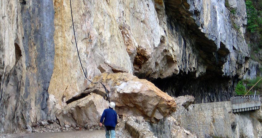
Due to their frequency and sometimes very large volumes in young mountain ranges (Himalayas, Andes, Alps…), rock falls, such as landslides, are among the major natural hazards. The rupture of the ground they imply takes place on surfaces of mechanical joints that are present in almost all rock masses. These result either from the genesis of the rock mass (stratification planes of sedimentary rocks, thermal retreat cracks of magmatic rocks…), or from their tectonic history (fractures and faults of all sizes, linked to the movements of tectonic plates). The instability of rock masses can remain superficial and concern limited volumes: very frequent block and particle falls in all relief areas. However, depending on the orientation of the main discontinuities with respect to the slope, larger rock slides or topples are also observed. Finally, large landslides can reach volumes of several tens of millions of m3. The rupture of such masses following an earthquake has unfortunately been observed several times (Huascaran 1970, Nepal 2014). Rock protection structures, such as supports, anchors, various nets… are possible. However, it remains economically difficult to equip all sites identified as being at risk, such as cliffs near cities, villages and mountain roads or the rocky coastline…
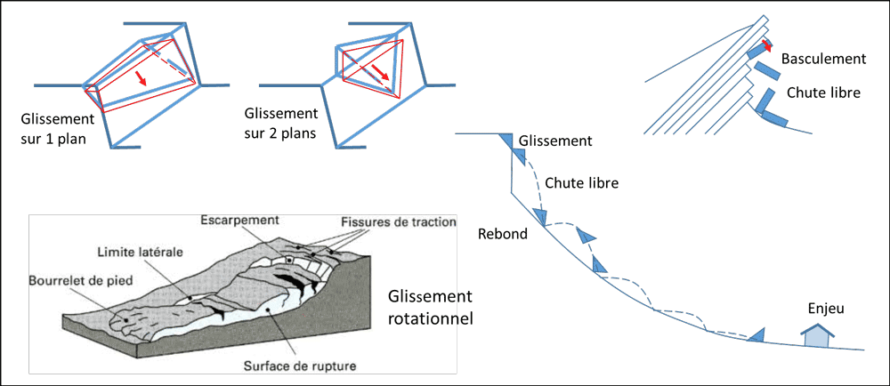
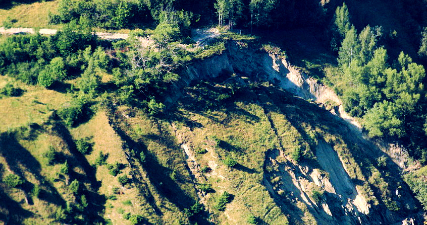
Slope movements are generally classified according to their mechanism. This is how we distinguish: slides, topples, falls, flows (Figure 1). They cover volumes ranging from cubic decimetres to several hundred cubic hectometres (one cubic hectometre corresponds to a 100 m ridge cube, or one million cubic metres).
Their speed is also very variable, from a few mm per year to more than 100 km/h (a value that approaches the free fall speed in the air). This article deals with landslides that can occur in the rock environment (see “Landslides“).
1. Rock slides
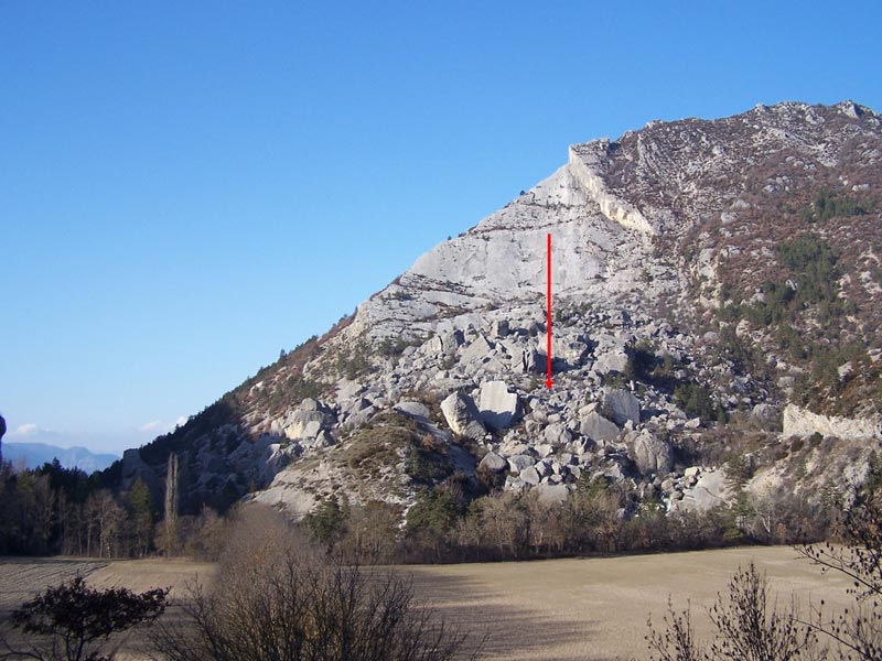
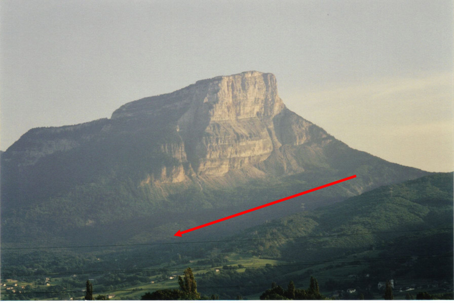
Translational landslides generally occur on one or two planes (referred to as “wedges”) of pre-existing discontinuity(s) in the rock mass. A well-known example in France is the Claps de Luc-en-Diois where, in 1442, thick limestone beds slipped on a stratification plane following the erosion of the foot of the slope by the Drôme river (Figure 2). The volume of the slip exceeds 1 hm3. But the largest landslide in the Alps in the last two millennia was the one that affected the marl slope north of Mont Granier in November 1248. Nearly 500 hm3 of marl rock slid eastward on the stratification joints, destroying several villages and killing more than 1000 people (Figure 3).
Some landslides can be triggered by humans. The most famous example is Mount Toc (Italy). Following the filling of the Vajont dam, 270 hm3 of rock slipped into the reservoir, causing the dam to overflow and a 50 m high wave that destroyed the city of Longarone (2000 victims). The movies “La folie des hommes”, released in 2001, recounts this disaster. This slide is the largest rapid slope movement that occurred in the Alps in the 20th century.
2. Topples
3. Rock falls
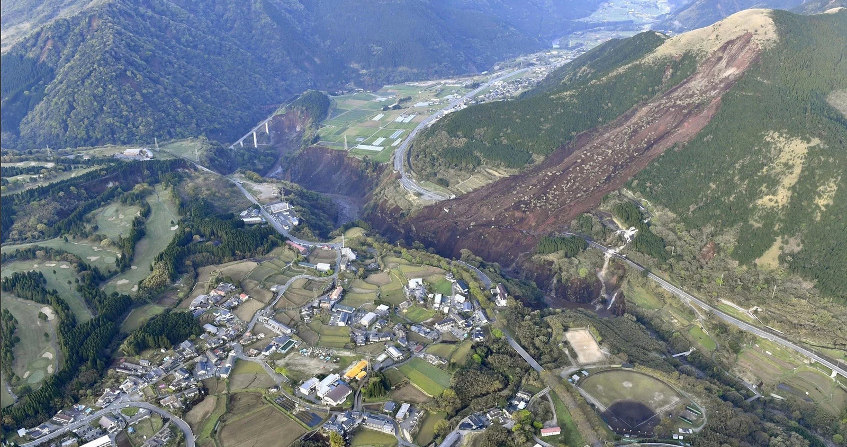
Rock falls are rapid movements involving blocks that fly, bounce or roll on a slope. Very frequent in mountainous areas, they can also be found in coastal areas on coasts with cliffs and rocky escarpments. These rapid movements are usually preceded by a sliding or toppling of the rock mass concerned. A distinction is made between rock or particle falls, for which the interaction between elements is negligible, rock mass falls and rock avalanches, which are granular flows in which the interaction between boulders plays an important role. The size of the elements varies from a few dm3 to several hundred m3. The total volume can reach several tens of hm3. Two landslides of this size occurred in the Alps in the 20th century, that of Val Pola in Lombardy (Italy) and that of Randa in Valais (Switzerland).
4. How to predict the behaviour of a slope?
Specialized engineers are called upon to study slope movements in different contexts: (a) diagnosis for a currently stable slope (for how long is its stability ensured?); (b) design of a future excavation (or cut) or reinforcement of an existing slope (what slope angle to adopt, how many anchors to make?); (c) monitoring of an unstable slope in slow movement (does the movement risk evolving towards a fast movement and when?). The methods used differ according to the context and objective of the study.
4.1. Stable slopes
In land use planning, the problem arises of the sustainability of the slope on a human time scale, of the order of the century. To know whether a failure is likely to occur within the time frame considered, it is necessary to know the current state of stability (“excess” stability) and the processes that can lead to the failure. The state of stability of a rock slope depends mainly on its internal structure (cutting of the rock by discontinuity surfaces), which is generally poorly known, and on the strength of the rock and discontinuities. The main factors that can reduce the stability of a rock mass and lead to its failure are: the presence of water, the presence of ice, earthquakes and other vibrations, erosion or excavation at the foot of a slope, overloading. The evolution of these factors, when they are of natural origin, cannot be predicted in a deterministic way. In addition, the exact processes by which they act are often not well known and therefore difficult to model. As a result, the prediction of the future behaviour of a stable slope can only be probabilistic, hence the term hazard used by specialists to characterize the potential instability of a rock mass.
In the case of a well identified rock mass (localized hazard), it is not possible to quantitatively determine a probability of rupture. On the other hand, on the scale of a slope or homogeneous area subject to slope movements (diffuse hazard), it is possible, from historical databases or geomorphological measurements (by laser scanner for example), to estimate the number of failures per unit area and time (failure frequency) for phenomena of a certain size. For example, it was determined from successive laser measurements of the cliff of Mont Saint-Eynard, near Grenoble, that there is about a fall in volume of more than 1 m3 per year per hm2 (hectare : square of 100 m on each side).
4.2. Desig of an excavation or reinforcement of a slope
In this context, the problem is no longer when instability will occur, but how to ensure that it does not. The stability of the envisaged slope can then be analysed by adopting a pessimistic model (in other words by applying the precautionary principle): most often, the lack of information leads to the assumption that the discontinuities are of infinite extension; the values of the various parameters used for the calculations are not the most likely, but more unfavourable values with a low probability of being reached. In addition, excessive stability is generally desired. If it is not reached, the project is modified accordingly, for example by reducing the slope angle.
The fastest method used to assess the degree of stability of a rock mass can be described simply in the case of a slide of a rock mass on a single plane: it consists in comparing the force that tends to cause the slide (driving force) with the maximum force that can be mobilized to oppose it (maximum resistance force). The ratio of the second to the first is called the safety factor. It must be greater than one for the proposed slope to be stable. The calculation of the driving force takes into account the weight of the rock mass, but also probable temporary phenomena such as earthquakes or water infiltration into the slope.
More sophisticated numerical methods, called discrete element methods, can also be used to calculate the block displacements resulting from excavation. These methods make it possible to analyze complex mechanisms and determine whether displacement is acceptable. Unlike the method described above, which is based on a static analysis, discrete element methods are based on the fundamental principle of dynamics, or Newton’s second law.
4.3. Monitoring of an unstable slope in slow motion
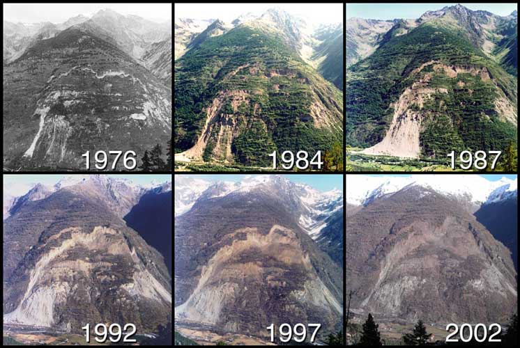
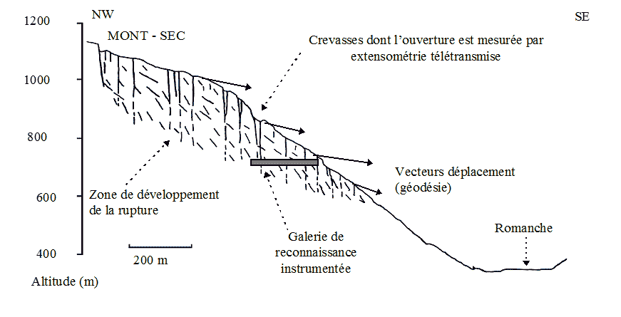
When slope movement is detected and threatens issues, it must be monitored. Monitoring generally involves measuring the movement of landmarks on the slope or in the rock mass, for example in boreholes or galleries. The movement velocity is rarely constant, it is generally influenced by water infiltration into the slope following rain or snowmelt and by earthquakes. Experience shows that when the speed increases in the absence of such external factors, acceleration can continue until the slope fails, when the moving mass is completely detached from its starting area and propagates downstream possibly at high speed. An example of a monitored slope is given in Figure 4 (see above).
5. How far can rock movements spread?
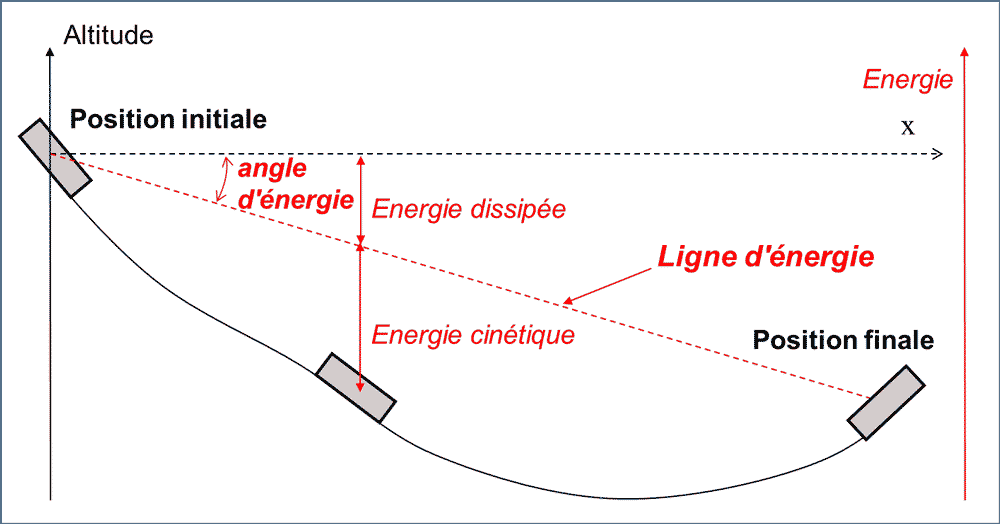
Various mechanical approaches can be used to estimate the propagation distance of rock movements. The first is based on the energy angle, which quantifies the loss of energy during the propagation of landslide (Figure 6). When the moving mass stops, its potential energy is lower than before the movement; in a slope profile, the stopping point can be obtained by drawing a line (energy line) from the starting area of the movement and with an inclination equal to the energy angle. In three dimensions, the stopping point belongs to the intersection of the topographic surface with a cone whose vertex is the starting area. For movements of several hundred hm3, the energy angle can be less than 10°. This is the case with the Granier landslide, which spread up to 8 km from its starting area. For block falls, the energy angle is about 40°, but it can drop below 30° for the furthest blocks.
The energy dissipated is mainly due to rebounds, which are not perfectly elastic, the fragmentation of blocks, the emission of seismic waves and possibly the destruction of trees.
In the case of rock falls, a second approach consists in calculating, using adapted software, the trajectories of the blocks that fall, bounce or roll on the slope. While the calculation of air trajectories is not a problem, rebound modelling is more difficult. This is done using energy restitution coefficients, which represent the proportion of the initial energy that is conserved after the bounce on the slope or after the impact with another block. In addition, the observation of the blocks deposited on a slope provides valuable information on the possible extension of the phenomenon, as well as on its frequency. However, this observation may be biased because blocks may have been moved or exploited in recent centuries.
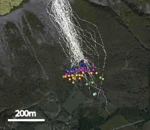
Figure 7 shows the simulation, performed with Rockyfor3D software, of a landslide that occurred on Mont Saint-Eynard, near Grenoble.
When the number of blocks is very large and the blocks interact strongly with each other (rock mass falls and rock avalanches), the movement can be considered as a flow and modelled using the laws of granular mechanics. This approach is also used to model landslides propagating over long distances in the manner of a fluid (rock slides evolving in mudflows).
6. Protection, or how to protect yourself from rock instabilities
In terms of natural hazards, two categories of protection are distinguished. The purpose of active protections is to remove the hazard itself, while passive protections do not seek to oppose natural phenomena but only to limit their harmful consequences for developments (buildings, communication routes).
The active protections are diverse. It is about:
- general methods, such as surface or deep drainage, and slope vegetation that limits erosion due to runoff (gully excavation) and infiltration that alters mechanical properties (friction, cohesion of rock joints);
- supports, such as retaining walls, rock bolts or anchored mesh covered with sprayed concrete;
- wire mesh (draped or pinned), i.e. metal structures designed to contain the massif and prevent the spread of falling rocks and blocks;
- scaling, mining: these are radical solutions that consist in removing unstable elements; however, these solutions are not always as definitive as expected: the continuous alteration and the vibrations of the blasts are often harmful to the stability of the surrounding massifs.
Passive protections are also very diverse:
- barriers (Figure 8) and dikes are gabions or concrete blocks placed at the foot of unstable slopes; their purpose is to stop the propagation of rock elements before reaching the stakes; their location, which requires sufficient space and their dimensioning, takes into account the properties of the materials that constitute them, but first of all numerical simulations that are made to model the propagation of blocks (trajectory circulations);
- the diverters are also embankments; installed on the slope, they divert the flow of the elements towards a space without stakes;
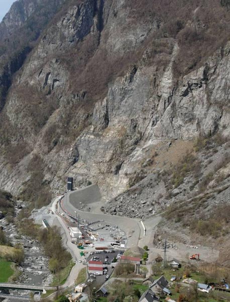
- protection galleries, similar to avalanche tunnels, are likely to protect communication routes when crossing corridors;
- rigid fences are placed on steep slopes as close as possible to the starting areas; their installation is often difficult to achieve;

- deformable wire-mesh (Figure 9) can be placed lower on the slopes until they are close to the issues at stake; the most well-known case is the use of “submarine” type nets (used during the Second World War to prevent the penetration of ports by submarine vehicles) stretched between rigid poles and maintained by fusible carabiners; this device is thus calculated to resist an impact energy previously determined in the study of randomness and its propagation.
The appropriate responses to reduce the risks associated with rock instabilities are effective but often require a large budget. We cannot consider eliminating risk wherever it exists. The best protection is always based first on geological reconnaissance, then on preventive actions such as drainage or regular purging of unstable elements and on monitoring based on measurements when movements are detected. Such monitoring often triggers an alert with a road closure or evacuation of an inhabited area.
The Encyclopedia of the Environment by the Association des Encyclopédies de l'Environnement et de l'Énergie (www.a3e.fr), contractually linked to the University of Grenoble Alpes and Grenoble INP, and sponsored by the French Academy of Sciences.
To cite this article: FABRE Denis, HANTZ Didier (January 5, 2025), Rock slides and rock falls, a fatality?, Encyclopedia of the Environment, Accessed July 16, 2026 [online ISSN 2555-0950] url : https://www.encyclopedie-environnement.org/en/soil/rocky-landslides-and-landslides-a-fatality/.
The articles in the Encyclopedia of the Environment are made available under the terms of the Creative Commons BY-NC-SA license, which authorizes reproduction subject to: citing the source, not making commercial use of them, sharing identical initial conditions, reproducing at each reuse or distribution the mention of this Creative Commons BY-NC-SA license.