Landslides
PDF
Landslides are one of the most prevalent natural hazards and affect all regions of the world, causing enormous damage each year in terms of both human life and material damage. They affect both natural slopes and man-made structures such as dikes, dams and embankments. The types of movements, causes, role of water and stabilization methods are discussed.
1. Landslides

We will deal here with movements concerning loose or indurated soils [1], typically natural soils, clays, sands, and all loose materials. These slopes can be natural or anthropogenic, such as excavated material, embankments, dikes and dams.
2. What types of movements?
3. How to study a slip?
4. How to explain a slip?
When a slip occurs, the analysis of the causes is done by looking for the different triggering factors: these can easily be listed from the quantities present in the equations of equilibrium, both on the driving forces and on the resistant forces.
The stiffening of a slope by earthworks, an overload at the head of the slope, a backfill built on a slope, excavated material at the base of the slope, are all examples of increased driving forces. Another case is that of earthquakes, where horizontal acceleration creates instabilities that are often very harmful when the emergency road network is impacted. Earthworks – even modest ones – at the foot of the slope can also lead to major landslides when they are carried out on sites that have already slipped but are currently stabilized.
The flow of water on a slope is also a driving force: the pressure drop during the flow is transmitted to the ground skeleton. The hydrogeological analysis of the slope is therefore essential and water also acts by its effect on the mechanical resistance of the soil.
The mechanical behaviour of soils at break is represented by Coulomb’s law and the shear strength includes a cohesion term and a friction term proportional to normal stress. But soils are two- or three-phase materials. There is therefore an interstitial pressure and the analysis can be done either in total stresses (considering the soil as monophasic) or in effective stresses with consideration of water pressures in the soil pores.
The analysis of the natural stability of the slope before the work that will modify its geometry is essential. This analysis should include geological and hydraulic conditions. It may also involve studying ancient fossil landslides that can potentially be reactivated: indeed, on ancient landslides, the residual friction angle created by large previous displacements may only be 20° to 10° and the residual cohesion is almost nil. This explains the landslides that occur on very shallow slopes when the role of water is present.
5. What is the role of water?
Water has several actions in landslides. Water inflows can be rainwater or groundwater from upstream. Rainwater can cause surface erosion and infiltration into groundwater.
An example helps to understand the effect of water. A slope in a totally dry sandy material is stable as long as the slope angle is lower than the friction angle F. The same totally flooded slope without flow is stable under the same conditions. When the slope is subjected to a flow whose free surface coincides with the topographic surface, the limiting equilibrium angle is about half of F. For a slick in flow parallel to the slope, the safety coefficient (reflecting the excess stability of the slope) decreases as the slick approaches the surface: this explains the landslides occurring after heavy rain causing the slick in flow to rise.
To this end, the role of water on the mechanical behaviour of unsaturated soils is added. Unsaturation creates a suction between the soil grains (see the sand castle and its vertical “walls”!) which can be interpreted as capillary cohesion. This is very favourable to stability, but it disappears when it is saturated, causing slippage.
Finally, when clays are sheared on a sliding surface, they undergo an increase in water content that reduces their shear strength.
6. How and why should a slope be examined?
The auscultation has different purposes and to achieve this different means of measurement are used [7]. First of all, it is necessary to provide the data necessary for understanding and analysing the slip in order to monitor and alert for possible treatment or reinforcement work.
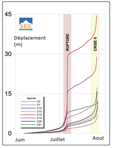
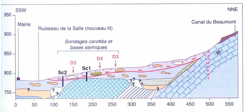
The other important parameter to be measured is the evolution of the depth displacements and the determination of the surface on which the movement takes place: the volume of the slippery mass can then be calculated and a retroanalysis of the slip can be carried out. Inclinometers are vertical tubes implanted in the slide, fixed at the foot of which the deformation over time is measured.
The role of water has been highlighted above. Several measurements are necessary, the first of which is the rainfall on or near the site. To access the hydraulic behaviour of the slope, the knowledge of flows and pore pressures is obtained from piezometers [5].
7. How to stabilize a slope?
Having defined the causes and geometry of the slip, the engineer can choose stabilization actions. In view of the major role of water, the control of infiltration water is the first action. This involves gutters, gutters, cunets, etc. to collect rainwater and transport it to outlets through pipes that are insensitive to ground movement. Draining massifs (foot masks, spurs perpendicular to the level lines, draining spiked trenches, etc.) improve stability by reducing pore pressure and increasing shear strength. To optimize the use of such works, reinforced embankments with stiffened facing are possible (reinforcement by geotextiles, reinforced earth, geogrids…)
Drilling with drains can be more than 100 metres long and can intercept deep water supplies or water flows occurring at layer interfaces. These drains are generally small in diameter and can be subject to clogging. In addition, in sliding areas, when you want to lower the slick beyond the sliding surface, you are exposed to pipe shearing and therefore to an opposite effect, supplying water to the shearing area. Drains can be made from galleries under the slide or by radiating subhorizontal drilling from shafts
Nailing slopes is a technique that has developed considerably over the past several years. These nails (32 mm diameter steel bar) are a few meters to a few tens of meters long and are sealed with a cement grout over their entire length according to a mesh of a nail per 1 to 4 m². They can work under normal stress, shear or bending. This nailing is completed by drainage behind a sprayed concrete mask reinforced with a mesh. Slope stabilization calculations by nailing are performed with conventional slope stability software.
In the case of previous slope slides, a special technique consists of using large-diameter piles (about one to two metres in diameter) to stabilize the slide. This heavy and costly technique is used to protect road, motorway or railway structures. However, the purpose of these structures is not necessarily to achieve complete slip stabilization, but to slow down the observed travel speeds to a low value and allow the structures to be returned to service.
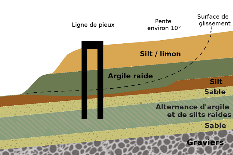
The piles are made of reinforced concrete or metal. Compared to conventional nailing techniques in slope stabilization, the piles have a higher inertia and work in bending, tension and compression. They are placed vertically and require larger access platforms for drilling machines. In sites that are often on the edge of stability, the use of drilled piles is almost always the appropriate solution. These piles are installed in one or more lines downstream and/or upstream of the structure to be protected. Pulled sills [6] can complete the device.
References and notes
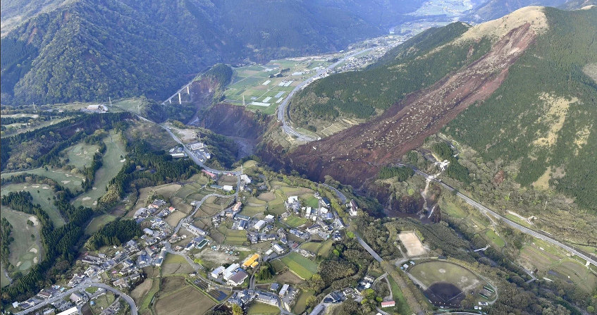
Cover image. Chambon landslide[Source: By David.Monniaux (Own work) [CC BY-SA 4.0], via Wikimedia Commons] For more information on the Chambon landslide: see ref .[7].
[1] Indurated soils refer to resistant soils or soft or altered rocks such as marls for example
[2] Mill, C., Hat C., Le glissement de la Salle en Beaumont. http://www.risknat.org/projets/riskydrogeo/docs/guide_pratique/Acivite1_Ateliers/Presentations%20Atelier2/A2P3-La%20Salle-%20Chapeau%20CETE.pdf
[3] Guilloux A. et al. Note on the definition of “Indurated Soils Soft Rocks SIRT” Revue française de Géotechnique, n°111, 2nd quarter 2005 pp 59-67
http://www.geotech-fr.org/sites/default/files/rfg/article/111-5.pdf
[4] LiDAR (light detection and ranging. Topographic measurement by emission of a reflected laser beam. We can thus obtain a digital terrain model in 3 dimensions
[5] Piezometer: device for measuring the water pressure at depth within the soil mass
[6] Reinforced concrete beams that are anchored by tie rods in the stable bedrock
[7] Dubois L. Le glissement du Chambon: evolution and crisis management https://jngg2016.sciencesconf.org/browse/session?sessionid=21782
The Encyclopedia of the Environment by the Association des Encyclopédies de l'Environnement et de l'Énergie (www.a3e.fr), contractually linked to the University of Grenoble Alpes and Grenoble INP, and sponsored by the French Academy of Sciences.
To cite this article: FLAVIGNY Etienne (January 5, 2025), Landslides, Encyclopedia of the Environment, Accessed July 2, 2026 [online ISSN 2555-0950] url : https://www.encyclopedie-environnement.org/en/soil/landslides/.
The articles in the Encyclopedia of the Environment are made available under the terms of the Creative Commons BY-NC-SA license, which authorizes reproduction subject to: citing the source, not making commercial use of them, sharing identical initial conditions, reproducing at each reuse or distribution the mention of this Creative Commons BY-NC-SA license.