


滑坡
滑坡是全球最普遍的自然灾害之一,每年都造成巨大的人员伤亡和财产损失。滑坡不仅涉及自然边坡,也会损毁河堤、大坝和堤防等人造建筑设施。本文讨论了滑坡的类型、成因、水的作用和加固方法。
1. 滑坡

[图片来源: SAGE, https://www.sage-ingenierie.com/glissement-de-terrain-du-chambon/]
滑坡是大量土体在重力作用下发生位移,其体积从几十立方米到几千万立方米不等。滑坡厚度从几米到几十米不等,表面积可以达到几平方公里。因此,滑坡的体量有极大的不确定性,小的滑坡可导致道路封闭,而大的滑坡可完全改变场地地形。滑坡既可能发生在地表,也可能发生在水下,甚至火星上也存在滑坡的痕迹。
本文讨论的滑坡主要指松散或硬质土体[1]的运动,包括自然土壤、粘土、沙土和所有松散的土体。这些斜坡可以是自然坡体,也可以是人造坡体,如堆填坡体、路堤、堤坝或水坝。
2. 滑坡有哪些运动类型?
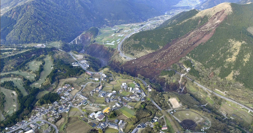
该处滑坡发生于2004年8月1日,沿表层红色崩积层运动,面积约7公顷,厚约10m。滑坡堵塞了RN85公路,摧毁了部分村庄,造成4人死亡。[图片来源: 米尔( Mill)和哈特(Hat),参见注释[2]]
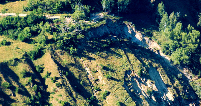
研究人员比较滑坡前后的地形总结出,滑坡过程中存在以下几种典型运动。第一种类滑坡在位移后,可以识别一个或数个摩擦破坏面。滑坡体的几何形状可以近似圆形,由数个块体组成,或者最终形成一个平面块体。这些滑坡体的上部有裂隙,下部为鼓丘状,如发生在博蒙地区拉萨尔(La Salle en Beaumont)(图 2)的滑坡便属于这一类型[2]。 第二种类型的滑坡是流滑,其中,滑移物质被转化为流体,借助斜坡或山谷的地形实现长距离流动。第一种类型的滑坡也可以转化为这一类型:例如发生在 意大利/坎帕尼亚(Sarong)的滑坡。最后,斜坡可能具有蠕动或泥流行为(浸水土壤表层的缓慢移动[3]):然后呈现为难以察觉的的缓慢移动(每年几厘米或几十厘米)。确定滑坡类型后,就可以对这些斜坡进行追踪监测,直至其运动演变为破坏失稳。
3. 如何开展滑坡研究?
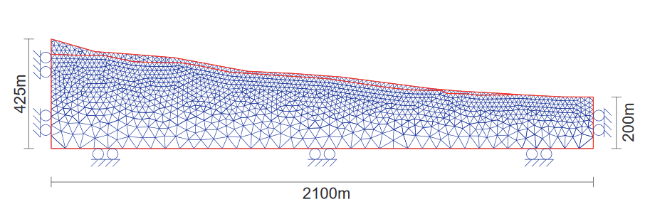
图片来源:弗洛伦特·布鲁尼耶(Florent Prunier)的博士论文,格勒诺布尔国家科学研究院,2008年https://tel.archives-ouvertes.fr/tel-00355769/document]
边坡稳定性研究或滑坡后的反演分析包含以下基本步骤。首先,对研究区进行完整地质调查,如几何结构、地层、地质历史等,识别已复活的古滑坡。其次,水文地质研究,主要涉及所研究斜坡的水循环,因为水通常是滑坡的驱动力(见本文5节)。第三,对边坡材料的水力和力学性能进行表征,尤其是渗透性和剪切强度,通常以扭矩(内聚力和内摩擦角)为特征。基于以上研究获取的信息和知识,可以建立边坡的力学模型和各种数值模型(由特定软件实现)。通过比较驱动力(重量、水流力、地震)和阻力(内聚力、摩擦力、加固…),确定边坡的稳定或不稳定。
4. 如何理解滑坡?
科学家们通过寻找不同诱因来分析滑坡产生的原因:根据平衡方程中驱动力和阻力的数量,可以很容易地列出这些影响因素。
在土方工程中,夯实斜坡、顶部过载、斜坡回填、边坡底部开挖,都可能增加驱动力。另一种情况是地震,水平加速度产生的不稳定性足以导致重大损失,如阻断应急路网。此外,如果在曾经发生过滑坡但目前表现稳定的地点进行小规模的土方工程,也可能导致重大滑坡。水在斜坡上流动所产生的压力降能传递至坡体结构,也能成为滑坡发生的驱动力。所以,边坡的水文地质分析同样必不可少,水还能通过影响土体阻力的发挥作用。
库仑定律能表示破坏时土体的力学行为,剪切强度包括内聚力和与法向应力成比例的摩擦力。由于土壤是两相或三相物质,存在孔隙水压力,因此可以考虑对总应力(考虑土体为单相)或有效应力(考虑土体孔隙中的水压力)进行分析。改造边坡的几何形状之前,一定要分析其稳定性。该分析应包括地质和水力条件。还可能涉及研究被重新激活的古滑坡:事实上,对于古滑坡,先前滑移产生的残余摩擦角可能只有10°到20°,残余内聚力几乎为零。这也解释了只要有水的作用,即使浅层斜坡也可能发生滑坡。
5. 水在滑坡中的作用是什么?
水在滑坡中作用颇多。流入滑坡体的水可以是雨水或来自上游的地下水。雨水不仅会导致地表侵蚀,还会渗入地下。
下面这个例子有助于理解水的作用。只要坡度角小于摩擦角F,完全干燥的砂质斜坡是稳定的。在相同条件下,同样的全淹水无水流边坡也是稳定的。当边坡受到自由面与地形面重合的水流作用时,极限平衡角约为F的一半。对于平行于边坡的渗流,安全系数(反映边坡的稳定性)会随着渗流接近地表而降低。这也解释了为什么暴雨后滑坡体内部渗流表面液位上升会诱发山体滑坡。最后,水的作用还包括对非饱和土体力学行为的影响。不饱和土壤会在土壤颗粒间产生吸力(参见沙堡及其垂直“墙”效应!)这种现象可以解释为毛细内聚力,有助于边坡稳定性,但此现象会在土壤饱和时消失,导致滑坡。
最后,粘土在滑动面上受到剪切时,其含水量会增加会降低抗剪强度。
6. 如何以及为什么需要监测边坡?
对边坡的监测分析目的各不相同,为达到不同目的会使用不同的监测方法。首先,有必要提供数据来理解和分析滑坡,以便监测和预警可能的处置或加固工作。
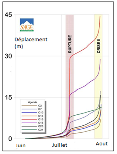
(rupture:破裂;crises:破坏失稳阶段)[图片来源: SAGE]
边坡的非侵入性表面测量基于地形地标,所有方法都可用于确定滑动表面的 x、y、z 位移(从传统地形到激光雷达技术( LiDAR) [4]或全球定位系统(GPS)技术……)。测量裂缝间距或地标的裂缝计也用处颇多。这些表面测量可提供滑移表面的相关信息。在某些情况下,监测位移的演化,尤其是运动的加速度,可以成功预测破坏失稳的发生。
另一个要测量的重要参数是深部位移的变化以及滑坡内部滑面的确定,基于此可以计算滑坡体的体积,并对滑坡过程进行反演分析。测斜仪是植入滑坡体的垂直管道,其管道底部固定不动,测量滑坡体位移随时间的形变。
前文已经强调了水在滑坡中的重要作用。进行测量是必要的,首先要测量现场或附近地区的降雨量。为获得边坡的水力特性,可通过水压力计[5]测得渗流和孔隙压力数据。
7. 如何加固边坡?
确定滑坡成因和几何结构后,地质工程师可采取措施加固边坡。鉴于水在滑坡过程中起到的作用,控制水流入渗是重中之重。这包括修建排水沟、排水槽等水利措施以收集雨水,并利用对地面形变不敏感的管道将雨水输送至排水口。排水设施(包括底部铺砌防渗漏底板、垂直于登高线的支沟、树枝状排水沟等)通过降低孔隙压力和增加抗剪强度提高边坡稳定性。此外,可以使用加筋饰面加固路堤(通过土工布,加筋土、土工格栅等),优化此类工程。
带排水管长度通常超过 100 米的钻孔可拦截地层界面处的水流。这些排水管通常直径较小,容易堵塞。此外,在滑坡区域,将渗流水位降低到滑面以下时会管道会受到滑面的剪切作用,往往使得结果适得其反,即通过管道向滑面区域供水。因此,排水管道可以在滑坡体(滑面)以下,或通过对竖井近水平辐射钻孔形成。
土钉法防护技术在过去几年得到大力发展。这些土钉(直径32 mm的钢筋)长几米到几十米,按照每1到4 m²一个钉子的网格要求,在其整个长度上用水泥浆灌注。它们可在拉伸、剪切或弯曲条件下工作。该构筑的完成需要喷射混凝土罩后排水,并用钢筋加固。计算该边坡防护的稳定性通常采用常规边坡稳定性计算软件。
先前的滑坡加固实践中,曾使用大直径抗滑桩(直径约1至2米)稳定滑坡。这种体积庞大且造价昂贵的技术常用于保护道路、高速公路或铁路设施。然而,这些结构的目的不一定是完全固定滑坡,而是要将观测到的滑坡位移速度减缓到一个较低值,恢复设施的正常使用。

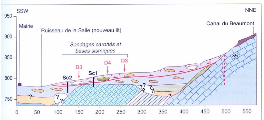
(silt:泥沙;argile raide:硬质黏土;graviers:碎石层)
这些桩由钢筋混凝土或金属制成。与传统的土钉技术相比,这类桩的惯性矩大,在弯曲、拉伸和压缩条件下工作性能更好。它们垂直放置,因此需要更大的施工平台。对于通常处于临近失稳状态的边坡,使用钻孔抗滑桩再合适不过。这些抗滑桩安装在待保护设施的下方和/或上方,呈一排条或多排线性排布。通常需要配合拉锚结构[6]完成抗滑结构的整体安装。
参考资料及说明
封面照片:位于法国尚邦市(Chambon)的一处滑坡,图片来源:仅戴维·蒙尼亚奥(David.Monniaux) [经维基共享资源],更多信息见参考资料[7].
[1] 硬质土壤是指抗性土壤或软质、蚀变的岩石,例如泥灰岩
[2] Mill, C., Hat C., Le glissement de la Salle en Beaumont. http://www.risknat.org/projets/riskydrogeo/docs/guide_pratique/Acivite1_Ateliers/Presentations%20Atelier2/A2P3-La%20Salle-%20Chapeau%20CETE.pdf
[3] Guilloux A. et al. Note on the definition of “Indurated Soils Soft Rocks SIRT” Revue française de Géotechnique, n°111, 2nd quarter 2005 pp 59-67
http://www.geotech-fr.org/sites/default/files/rfg/article/111-5.pdf
[4] LiDAR:光探测和测距技术,即激光雷达。通过反射激光束进行地形测量,可以获得三维数字地形模型。
[5] 孔隙水压力计:用于测量土体内部孔隙水压的传感器
[6] 拉锚结构:由拉杆锚固在稳定基岩中的钢筋混凝土梁
[7] Dubois L. Le glissement du Chambon: evolution and crisis management
https://jngg2016.sciencesconf.org/browse/session?sessionid=21782
环境百科全书由环境和能源百科全书协会出版 (www.a3e.fr),该协会与格勒诺布尔阿尔卑斯大学和格勒诺布尔INP有合同关系,并由法国科学院赞助。
引用这篇文章: FLAVIGNY Etienne (2024年10月18日), 滑坡, 环境百科全书,咨询于 2026年7月24日 [在线ISSN 2555-0950]网址: https://www.encyclopedie-environnement.org/zh/sol-zh/landslides-2/.
环境百科全书中的文章是根据知识共享BY-NC-SA许可条款提供的,该许可授权复制的条件是:引用来源,不作商业使用,共享相同的初始条件,并且在每次重复使用或分发时复制知识共享BY-NC-SA许可声明。