泥炭地与沼泽——非凡的湿地

Encyclopédie environnement - tourbière marais - Le Lac Luitel

  泥炭地指植被能够产生富含有机碳的泥炭土的湿地。根据泥炭地的水源来源和水的化学特征,可以将泥炭地或泥炭沼泽(即英文中的Mires,指当今仍在继续发育和积累泥炭的泥炭地,但非专业文献一般不对二者作区分——审核者注)划分为许多类型:酸性泥炭藓雨养沼泽、碱性矿养沼泽、芦苇和莎草类沼泽。泥炭地以其独特的生物多样性著称:许多栖息地、植物以及动物(在法国)往往面临消失或具有非常特殊的适应性,例如食虫植物或动物的抗寒机制。因此,有必要对泥炭地进行保护性管理。此外,泥炭地还具有其他重要功能:调洪蓄水、碳储存、提供各式各样的产品,如芦苇、泥炭、野味、粗放型畜牧业,以及教育展示作用。泥炭还能提供过去植被、气候变化的环境记录,以及末次冰期冰盛期以来12000年间某些人类活动的年代学记。

1. 泥炭地在湿地中的地位

  湿地的定义因其时空范畴和利用者而异,所以较为复杂。拉姆萨尔公约(1971年)给出的定义很宽泛:“湿地是指天然或人工的、长久或暂时的沼泽地、矿养泥炭沼泽、泥炭地或开阔水域,包括静止或流动的淡水、半咸水或咸水水体,以及低潮时水深不超过6米的沿海区域[1]。”因此,湿地也包括珊瑚礁和波希多尼亚海草床(Posidonia beds)!这些区域构成了陆地生态系统与严格意义上水生生态系统的交叉区域,并与两个系统紧密交织在一起。

  相比而言,法国《环境法》中对湿地的定义更具限制性:无论其是否被开发,湿地是“通常长期或暂时被淡水、半咸水或咸水淹没或充斥的土地;如果存在植被,一年中至少有一部分时间以湿生植物为主”[2]。除了在此提到的两个要素(典型植被),在应用通告中还增加了第三个同等重要并且具有根本意义的要素:土壤性质

环境百科全书-泥炭地-一片未发育泥炭的湿地
图1. 卡马尔格保护区珊苏里(Sansouïres),一片未发育泥炭的湿地。
[图片来源:O.曼尼维尔(O. Manneville)]

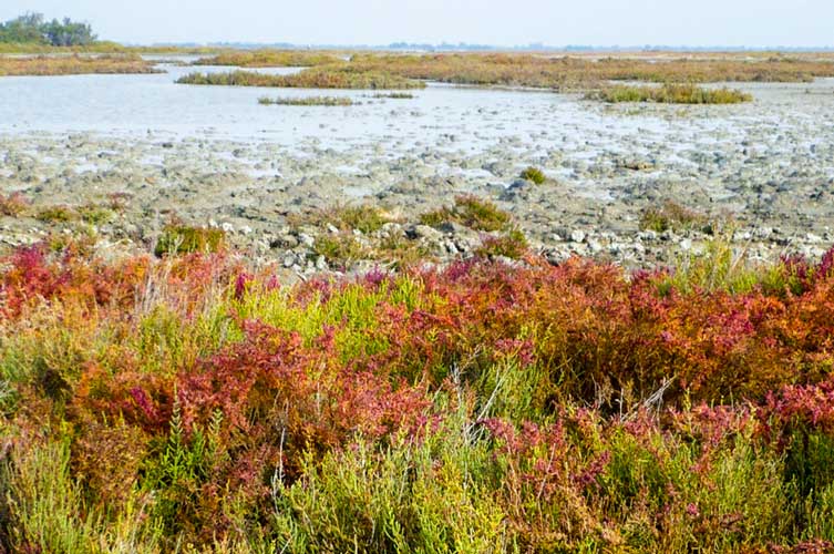
  将泥炭系统(泥炭地和大多数沼泽)与其他湿地类型区分开来的是土壤性质的差异。根据定义,泥炭沼泽是生长在低渗透性土壤上的植被定居的湿地,至少有部分土壤由厚度至少为30至40厘米的泥炭构成[3]。尽管盐碱地(法国雷岛盖朗德地区)、盐沼地(卡马格地区圣米歇尔山海湾,图1)和各种沿海或冲积沼泽对水或生物多样性同样重要,但由于其中没有泥炭的存在,在此不加以描述。

  湿地是亟需保护的重要生态系统。本文强调所有类别的湿地在全球生态平衡中发挥着许多不可或缺的作用,这一内容将在下面进行讨论。由于各种原因,大约两个世纪以来,湿地受到了人类活动的严重影响,这就是为什么在过去的半个世纪里,从区域到国际层面都启动了许多研究或保护计划[4]

2. 泥炭的性质及泥炭地功能

2.1. 泥炭是一种含碳的有机物质

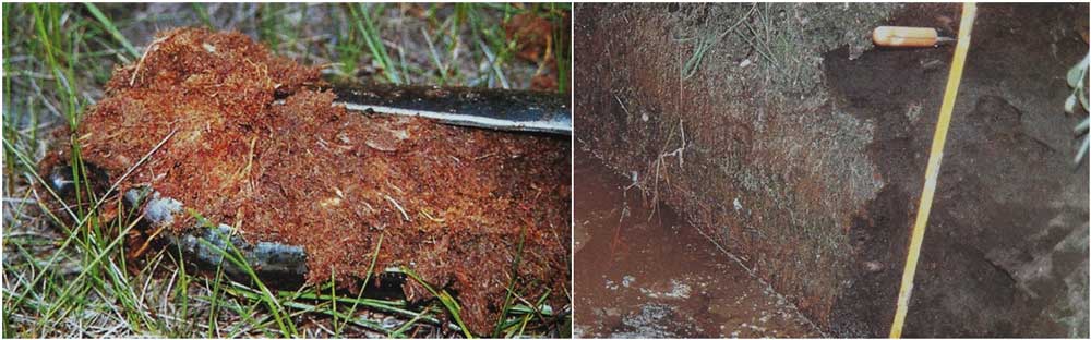
  泥炭至少由20-30%不完全分解的有机物组成,有时甚至更多。后者来自于几个世纪或几千年来,在一个长期淹水的环境中积累的植物残体(苔藓植物和高等植物)[3]

  水长期停滞或流动性不强导致高度缺氧,抑制了微生物的活性,大大减缓了植物碎屑的分解和循环,促进了泥炭形成。泥炭含有非常丰富的含碳化合物,同时也是一种腐殖质、一种土壤(名为有机土)和一种不完全的沉积岩,与煤炭相当接近。它可以被提取,用于构成低性能燃料,或者在干燥且含氧量较高的环境中缓慢降解并用作各种农作物的肥料[3]

环境百科全书-泥炭地-泥炭
图2. 两种类型的泥炭。左图,金黄色的泥炭与泥炭藓在一个取芯钻中。右图,来自芦苇和其它植物的黑色泥炭,在酸性较低的环境中。
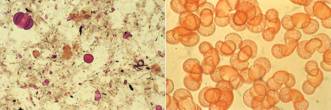
[图片来源:A.拉普拉斯-多隆德(A. Laplace-Dolonde)]

  只有一种泥炭吗?泥炭有很多种类,这取决于其所积累的植物和物理化学条件(图2)。例如,金黄色的泥炭来自于在酸性(有时pH值<4)和低温介质中的泥炭藓。但并非所有的泥炭地都是酸性或来自于泥炭藓,相反,在平原或海边的芦苇沼泽地,泥炭地的pH值可以超过7。

  泥炭自下而上形成,最古老的层次位于泥炭沼泽的底部。不同地区和时期的积累速度差异很大,但总体上平均每年1毫米,即每千年1米。也有少数例外,欧洲目前最古老的泥炭地,大约有11000到12000年的历史,实际上对应着超过10米的泥炭。

环境百科全书-泥炭地-植物碎屑
图3. 从泥炭(左)和松树孢粉(右)中提取的植物碎屑。
[图片来源:V.维尔格纳(V. Vergne)]

  此外,泥炭,或者说泥炭地,在第四纪末期起到了环境记录的作用。事实上,每一层泥炭都能保留很长时间,特别是由于缺氧、化学物质(如铅)、植物碎片(花粉粒、泥炭藓、木质树干的尖端;图3)或动物遗骸(昆虫、腹足动物)和原生动物。此外,泥炭中的碳元素可以通过C14方法进行相当精确的年代测定。因此,将年代学与这些不同标志物的性质和丰度结合起来,从底部到顶部分析泥炭芯,就有可能重建自末次冰期冰盛期结束以来的区域气候演变,调查地点的主要植被(北方苔原、松树和桦树泰加林或山毛榉林)以及各种人类活动的出现(比如古代的开垦和种植,罗马时代铅的使用等等)[3]

  我们还发现了在泥炭中保存数千年之久的祭祀用活人祭品,如丹麦的图伦男子[10]

2.2. 泥炭地的分布与起源

环境百科全书-泥炭地-泥炭地的全球分布
图4. 泥炭地的全球分布。泥炭地高度丰富的地区为深绿色,中度至低度为浅绿色,极低度为白色。资料来源:曼维尔(Manneville), 维尔格纳(Vergne)和维勒普(Villepoux)(2006), 见参考文献[3]

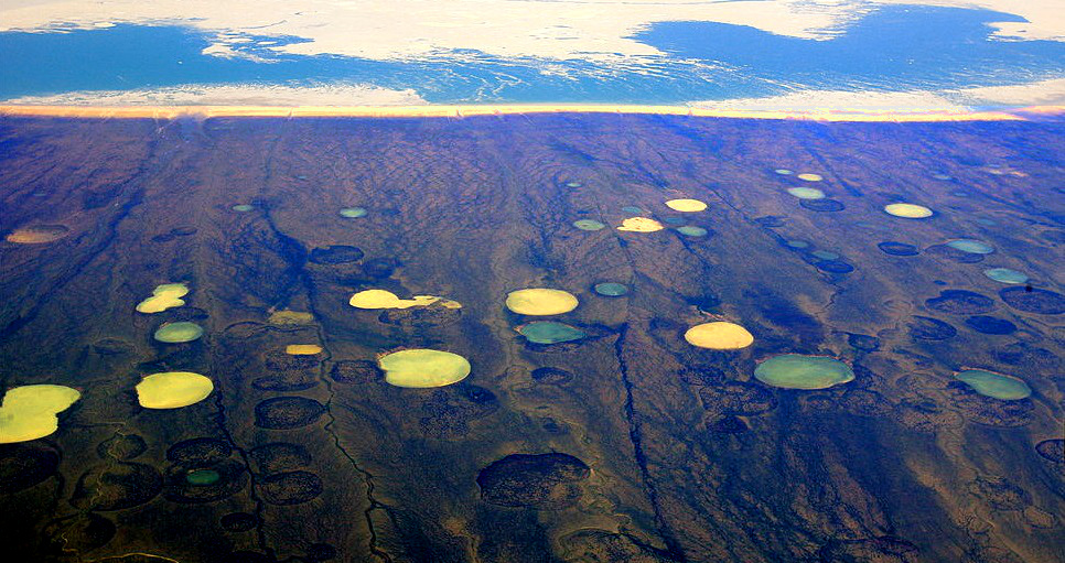
  对全球泥炭地分布的分析(图4)展示了两种与特定的气候,特别是与水平衡相关的主要生物地理区域[3]。首先是一些温度高且降雨量大(每年数米)的赤道和潮湿热带地区(如亚马逊、印度尼西亚和马来西亚等)拥有大面积的森林泥炭地。

  另一种类型覆盖了南北半球的中高纬度地区,处于温带或北方气候带非大陆性气候地区,大多分布在加拿大、不列颠群岛、斯堪的纳维亚半岛、波罗的海国家和俄罗斯,或南半球的巴塔哥尼亚、智利和凯尔盖朗群岛。在稍低和较暖的纬度,泥炭地则被庇护于山区或沿海地区——法国的情况就是如此。上述这些不同地区的温度相当适中,四季变化很大,年降水量在一米以下到两米左右。像太过干燥的沙漠,或太过寒冷的高纬度和高海拔等极端气候区,则不会有泥炭沼泽分布。

  这些截然不同的泥炭地之间的共同特点是它们都需要足量的水留存在泥炭系统中;在温暖的气候条件下,需要大量的降水,而在较寒冷的气候条件下,只需要较少的降雨量,因为在较冷气候条件下蒸散作用强度更低。其它有利因素是地形矿物底土的性质,流入泥炭系统的水必须存储相当长的一段时间,而非太快流向下游或流入多孔底层。在局部的山脊、山坡或过渡区也存有泥炭地,它们则依靠常年的雾汽或泉水输入。

环境百科全书-泥炭地-冰川对泥炭地的地貌和起源的影响
图5. 冰川对泥炭地的地貌和起源的影响。[图片来源:曼维尔(Manneville), 维尔格纳(Vergne)和维勒普(Villepoux)(2006),见参考文献[3]] (图5:Lac d’ altitude 高海拔湖泊;Cirque de glacier actuel 当前的冰川圈;Eau 鳗鲡;Neige glace 雪与冰;Marais 沼泽地;Tourbe 泥炭;Sédiment peu perméables 低渗透沉积物)

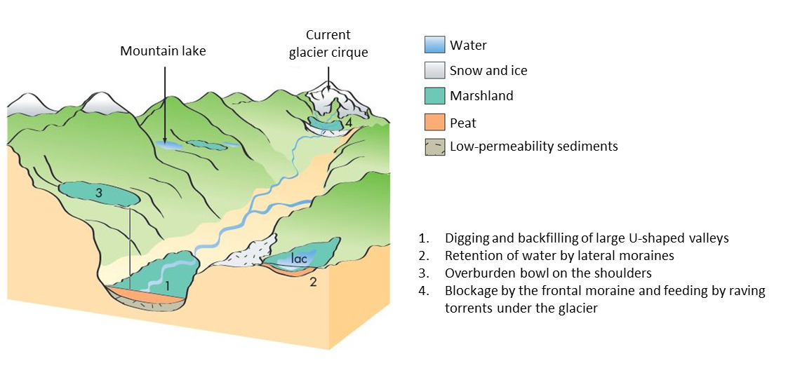
  如上所述,法国和欧洲的大多数泥炭地主要起源于第四纪冰川消退之后的全新世。在冰川时期,由于过度寒冷和干燥,植物无法正常生长。此外,在冰冻地区,冰川活动(侵蚀或冰碛沉积)刮去了老的泥炭层,同时创造了有利于现有泥炭地出现的新的地形(特别是创造了许多湖泊或洼地以及冰碛沉积)(图5)。然而应该注意的是,与有些观点相反,许多泥炭地并非发育在湖泊或池塘之上!

  泥炭为泥炭地形成提供条件,而泥炭地则产生泥炭!泥炭地的一个显著特点是,生活在那里的植物通过逐渐积累它们的残体而建造了泥炭沼泽;这个过程一旦开始,一些植物便会开始产生泥炭,而泥炭的存在则支持这些植物的存在。因此,它们是自我构建的生态系统,可以经历几个连续的进化阶段。

2.3. 泥炭地的多样性及其演化

  在现实中,泥炭沼泽与泥炭地的多样性非常重要,特别是在法国及其周边国家[3]。在此不可能介绍所有类型的泥炭地,故只介绍两个非常不同且具有代表性的例子。

环境百科全书-泥炭地-泥炭地阶段
图6. 左边是卢特尔湖,有浮毯和矮松——初始阶段,右边是卢特尔山口的沼泽地,有鞘羊胡子草,即白毛羊胡子草(Eriophorum vaginatum)和钩松——更高级的阶段。
[图片来源:曼维尔(Manneville)]
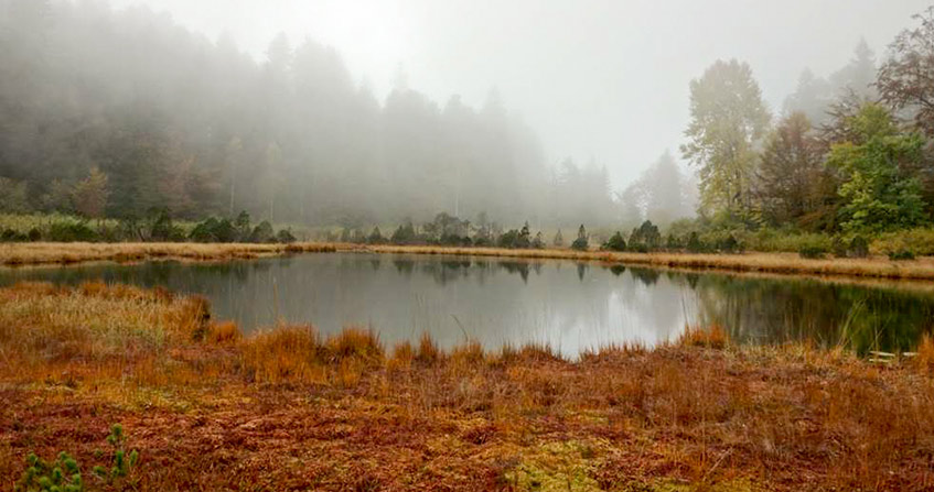
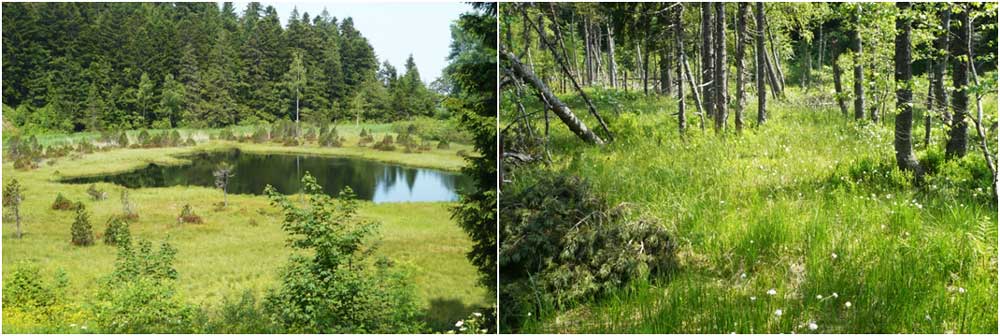
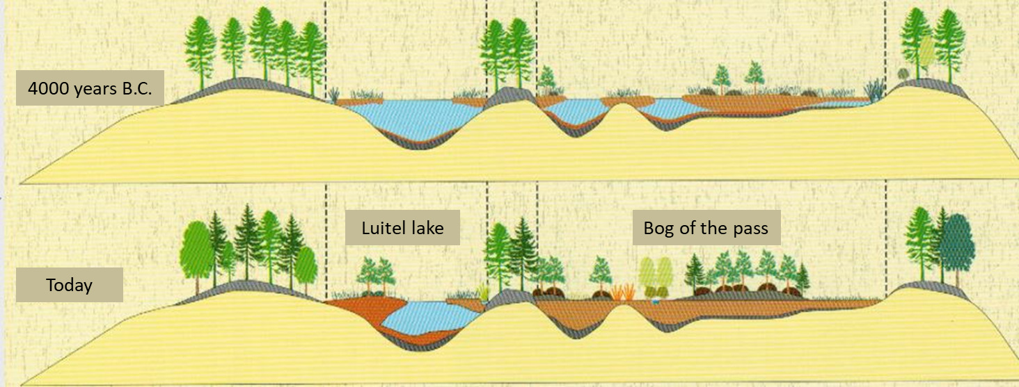
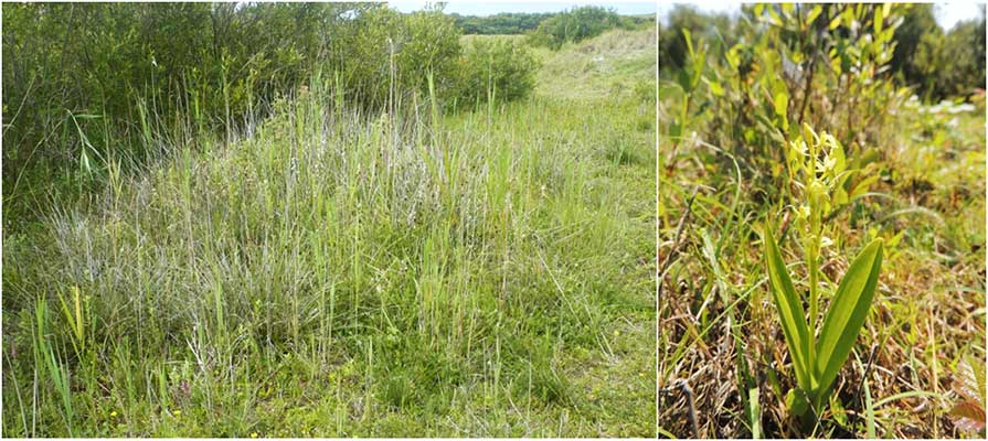
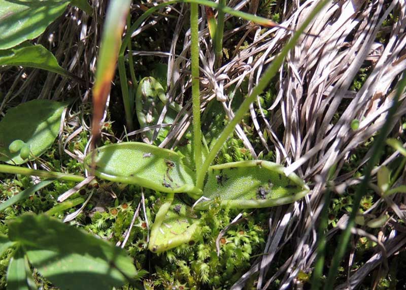
  在我们的山地丘陵上存在有明显特征的泥炭地系统。法国卢特尔湖泊国家自然保护区(伊泽尔省塞希利安,贝勒多讷结晶山地, 1250 m)的情况便是如此[5],它呈现了在冰川湖泊上发育的酸性泥炭藓泥炭地的模式(图6)。从湖边漂浮着泥炭藓和其他特殊植物浮毯的湖泊,到有泥炭藓的雨养沼泽,以及有钩松的木本雨养沼泽,上千年过程中的不同演化阶段皆得以呈现(图6和图7,[5])。虽然有来自上游的水流入沼泽,但主要还是由酸性和矿物质含量较低的雨水为植被和泥炭生产提供条件,这被称为贫营养输入。不断向上生长的泥炭藓通过其死亡部分产生泥炭,抬高了沼泽表面并允许木本沼泽的发展。在这一点上,地下水完全摆脱了径流而独立运行。类似的系统也存在于孚日山脉和比利牛斯山脉。

环境百科全书-泥炭地-卢特尔沼泽地演化的两个阶段
图7. 卢特尔沼泽地演化的两个阶段。[图片来源:德斯普朗克(Desplanque)和卡维(Cave)(2011), 见参考文献[5]] (图7:4000 years B.C. 公元前4000年;Today 今日;Luitel lake 卢特尔湖;Bog of the pass 隘口沼泽地)

  侏罗山脉的许多沼泽地也遵循类似的趋势,但它们最初是从由地表石灰岩水供应的矿养泥炭沼泽开始的[6]。更加寒冷潮湿的气候使泥炭地逐渐酸化,导致其比阿尔卑斯山地区的泥炭地隆起得更快。在所有情况下,这些泥炭地由于受到条件的限制(寒冷的气候、贫瘠的基质),其动植物类群都更接近欧洲北部地区,生产力也相对较低。

环境百科全书-泥炭地-碱性平地沼泽
图8. 左边是位于大科隆比耶山脚下的薰衣草沼泽(法国安省)。右边是沼泽大戟(Euphorbia palustris),一种冲积沼泽的大型植物。[图片来源:O.曼维尔(O. Manneville)]

  第二个例子涉及平原或冲积谷地的大型湿地。它们被称为碱性平地沼泽,但它们也产生泥炭,其性质和来源与卢特尔的不同。例子有博里埃(卢瓦尔河流域)、威尼尔沼泽(厄尔省)、圣冈德沼泽(马恩省)和薰衣草沼泽(安省)(图8)。后者[7]最初的面积为几百公顷,位于海拔230米处,由罗纳河及其支流的周期性洪水和附近石灰岩丘陵的泉水提供滋养。这是一个矿养系统,其降雨的直接作用很小;地下水是钙质的,pH值在6到8之间,富含矿物质。在泥炭中穿插有泥砂层以及河流沉积物。这里没有泥炭藓,但有许多较高生产力的维管植物(芦苇、大型莎草、桤木和柳树等),这得益于这里炎热的小气候和较高的营养水平(高浓度NO3–离子的存在)。这也使得这些沼泽在7000年内积累了超过10米的黑色或棕色泥炭。但因为处于地下水位之上的凋落物在夏季分解非常快,故泥炭沼泽并没有隆起。沼泽中的植被不再类似于北方地区,主要是由于周边生态系统中的许多物种可以在沼泽中定居(图8)。

  此外,法国在没有任何初始水体的阿莫里卡山和中央山丘、孚日山脉或科西嘉山丘上,或沿着与渗流和泉水有水文联系的山坡,或同样在从敦刻尔克到巴约纳的沙质淤泥海岸的后潮间带洼地,均存在各种特殊的泥炭系统[3]

3. 泥炭地和沼泽地是生物多样性的家园

3.1. 每个特定的泥炭生境都包含特殊的动植物类群

环境百科全书-泥炭地-多样性
图9. 左边是菲尼斯泰尔省(法国布列塔尼大区)的一个具有群体利益的泥炭生境(碱性沙丘洼地的肖努斯沼泽);右边是受这种环境保护的兰科植物罗氏羊耳蒜(Liparis loeselii),它在整个欧洲都在衰退。[图片来源 C.曼维尔(C. Manneville)]

  除上文概述的泥炭地之间的多样性之外,在一片泥炭地内也存在沿水分梯度呈现的多样性。因此一种生物多样性被嵌套在多个尺度上;这解释了泥炭地为何引起科学家和博物学家的兴趣,理解其功能的复杂性以及对生活或过境的许多物种进行保护性管理的困难性(图9)。此外,泥炭地随着时间的推移而演变,因此其栖息地(=微生物群和相关的生物群)及其物种不可避免地、周而复始地出现或消失。

  欧盟保护着泥炭地和它们的主人。在欧洲,许多湿地,特别是泥炭地的动植物物种和栖息地已经变得稀有或受到威胁(图9)。《欧洲栖息地指令》(1992)列出了这些受威胁的物种和栖息地;欧盟所有国家都有义务采取保护或保育措施。国家自然历史博物馆已经出版了有关法国境内物种和生境的指令性文件[8]

  除开物种清单或空泛的统计数据,下面介绍一些具有特殊生物学意义的泥炭地和沼泽物种。

3.2. 植物适应营养限制的例子

  在植物正常进行光合作用的情况下,泥炭地中水的持久性和特性会减缓植物对矿物营养(阳离子和硝酸根离子)的吸收;这里有三个适应这些限制的例子[3]

环境百科全书-泥炭地-已捕获苍蝇的捕虫堇属植物的叶子
图10. 已捕获苍蝇的捕虫堇属(Pinguicula sp.)植物的叶子。
[图片来源:C.曼维尔(C. Manneville)]

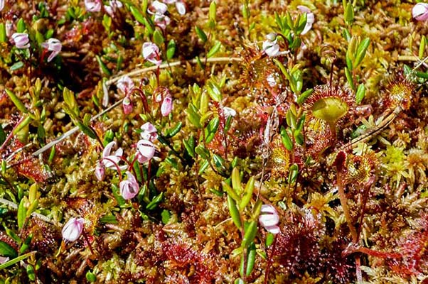
  由基质缺氧造成的硝酸盐缺乏,已经被生活在欧洲泥炭地或死水潭中的食肉植物以一种非常原始的进化方式得到解决。狸藻属植物、茅膏菜属植物和捕虫堇属植物(图10)已经进化出各种类型可以捕获节肢动物的陷阱,并用酶消化它们,然后直接吸收氨基酸,用于重建自己的蛋白质。

  木本植物为它们的氮营养发展出另一种策略:与其他生物共生。因此,杜鹃花科植物(图11)与能够吸收对大多数其他植物有毒的NH3+离子的各种真菌形成地下菌根;桤木属植物和大西洋灌木香杨梅作为宿主,会在其根瘤中寄生能够直接固定溶解在水中的分子氮的细菌(见《共生与寄生》)。

环境百科全书-泥炭地-泥炭藓
图11. 泥炭藓毯上有一朵欧石楠属植物的花,蔓越莓或红莓苔子(Vaccinium oxycoccos),以及茅膏菜,即圆叶茅膏菜(Drosera rotundifolia)。[照片© O. 曼维尔(O. Manneville)]

  泥炭藓(图11)最常生活在阳离子含量很低的酸性环境中(pH5或更低)。这些苔藓把水储存在特殊的死细胞和空细胞中,具有利用质子泵把外部水的矿物质阳离子与本身的H+离子交换的特性。这使它们能够获取养分。但外部的pH值会随着时间的推移而降低,这对泥炭沼泽中的其他植物是不利的,因此在与泥炭藓的竞争中处于下风。法国大约有40种石炭藓,每一种都生活在一个特定的湿度和pH值范围内;随着微观条件的演变,它们可以逐渐相互取代。除了死亡植被的堆积,这同样有助于浮毯演变为隆起的沼泽。

3.3. 泥炭地动物[3]

环境百科全书-泥炭地-胎生蜥蜴
图12. 泥炭藓毯上的胎生蜥蜴(Zootoca vivipara)。
[图片来源:德拉赫耶(Th. Delahaye)]

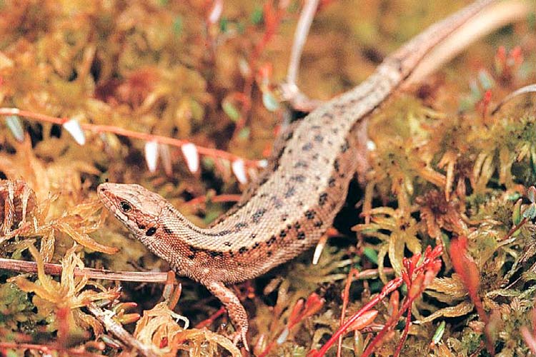
  诸如法国山区或北部等寒冷潮湿的沼泽并不利于爬行类这样的冷血动物,特别是对于繁殖而言。但是极北蝰蛇(Vipera berus)胎生蜥蜴已经解决了这一问题:它们不会产下在泥炭地中难以发育的卵,而是产下立即能够破壳活动的幼崽。 此外,在泥炭地中,这些动物的皮层通常很黑,这让它们可以被阳光温暖,胎生蜥蜴(图12)的血液可能含有防冻物质,使其在晨霜期间保持活跃(晨霜在几乎所有的泥炭地中都非常常见,夏季也是如此)。

环境百科全书-泥炭地-蜻蜓和蝴蝶
图13. 左边是短斑白颜蜻(Leucorrhinia dubia),一种生活在酸性山区泥炭地的蜻蜓。右边是一种沼泽蝴蝶,曲斑霾灰蝶(Maculinea nausithous),在地榆(Sanguisorba officinalis)上产卵。[图源:左图:克里斯蒂安-费舍尔(Christian Fischer),(CC BY-SA 3.0), 维基共享资料。右图:埃利奥特纳(ElliOrtner),(CC BY-SA 4.0), 维基共享资料]

  蜻蜓只生活在寒冷的沼泽中,它们的幼虫必须在恶劣的贫瘠环境中才能生长和觅食。如果有必要,这些幼虫在水中等待三年后才会蜕变为成虫,在新的地点定居(图13)。

  一些低地的碱性沼泽地仍有霾灰蝶(法语为azuré)属的蝴蝶。在拉武尔(Lavours)沼泽地有三个典型的霾灰蝶物种,这些物种在欧洲已经很罕见,因此被列入了《欧洲栖息地指令》[7]。其中一种的毛虫初生之时,以龙胆花(Gentiana pneumonanthe)为食,另外两个种类的毛虫则以地榆的头状花序为食(图13)。仲夏时节,几毫米长的毛虫掉到地上,被各种褐蚁属(Myrmica)的蚂蚁捡到。由于它们身上的化学物质对蚂蚁有吸引力,使得毛虫能够在不被发现的情况下被引入蚁穴;它们花几个月的时间以蚂蚁的卵和幼虫为食,然后在7月蜕变,完成它们的生命周期。这种多伙伴系统非常脆弱,因为如果宿主植物或宿主蚂蚁消失了,蝴蝶也会消失。

4. 泥炭地和沼泽的重要性和地位:它们需要保护
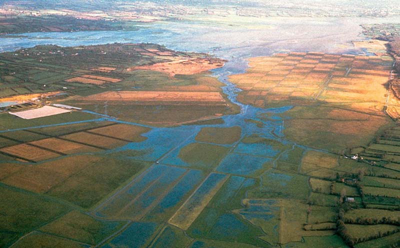
环境百科全书-泥炭地-科唐丁和贝桑沼泽地
图14. 科唐丁和贝桑沼泽地(芒什省)的冬季洪水。[图源:A. 拉普拉斯-多隆德(A. Laplace-Dolonde)]

  50多年来,人们一直在强调湿地的生态(同时也是经济)重要性[3]。这首先涉及到;盆地上游的泥炭沼泽和冲积平原沼泽通过将水储存在泥炭中,然后慢慢释放出来,以此减缓洪水泛滥,降低水位(图14)。此外,在沿着河道通过泥炭地和其上植物的过程中,水得到过滤和净化。

  生物多样性维持以及各种产品提供(芦苇收获、狩猎、淡水渔业、粗放式畜牧)是泥炭地与沼泽最基本的生态功能(见上文)。同时我们也要意识到它们在泥炭生产、环境记录、以及历史、传统文化、娱乐和教育等方面的价值[3] [7]

环境百科全书-泥炭地-雨养泥炭沼泽中的火灾
图15. 圣米歇尔山地区一处雨养泥炭沼泽中的火灾。
[图源:A.拉普拉斯-多隆德(A. Laplace-Dolonde)]

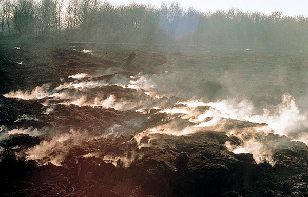
  地球上的泥炭地储存了碳,减缓了温室效应。几千年来,地球上积累的所有泥炭含有约5000亿吨的碳(5 × 10¹¹吨),相当于七十年的人为温室气体排放[9]!泥炭地占地球表面的3%,但储存的碳是所有森林总和的两倍。然而,排水或全球变暖导致泥炭分解和消失,随之而来的是二氧化碳和甲烷释放到大气中。泥炭地火灾带来的巨大影响(图15)也值得注意,无论是在西伯利亚、马来西亚还是在印度尼西亚。(见《被人类活动干扰的碳循环》)。

  据估计,在过去200年左右,法国和邻国有50-75%的泥炭地(和其它湿地)被破坏或严重退化。造成这种现象的原因有很多:

– 为了玉米种植或杨树和针叶树种植而进行的排水疏干;
– 破坏性的工业泥炭开采;
– 因人工池塘或水库大坝的建造而被淹没;
– 填埋场回填,城市扩张和运输、能源等基础设施兴建;
– 各种类型的污染,包括加速泥炭分解的潜在富营养化。

  尽管阻碍决策的惯性思维仍然存在,但保护现有泥炭地和尽可能多地恢复泥炭地的亡羊补牢的意识已经出现[4]。在法国,位于贝桑松的国家泥炭地协调中心就负责收集关于生物多样性和自然栖息地的信息,并向各类管理机构,如自然公园、自然保护区、保护站和各种地方当局传播知识和技术。


参考资料及说明

封面图片:秋天的卢特尔湖(法国伊泽尔省),其浮毯上有红色的泥炭藓。[图片来源:A.默西埃(A. Lemercier)]

[1] www.ramsar.org

[2] www.legifrance.gouv.fr/(Art. L.211-1) (in french)

[3] Manneville O., Vergne V., Villepoux O. et le Groupe d’Etudes des Tourbières (2006) 2e édition révisée. Le monde des tourbières et des marais. Delachaux & Niestle, 320 pages. (in french)

[4] Barnaud G. & Fustec E. (2007) Conserver les zones humides : Pourquoi ? Comment ? QUAE-EDUCAGRI, 296 p. (in french)

[5] Desplanque C. & Cave B. (2011) Réserve naturelle du Lac Luitel – livret-guide. ONF-Isère, 14 p.; http://www.reserves-naturelles.org/lac-luitel (in french)

[6] Blanchard O. (2011) Tourbières – A l’épreuve du temps. Collection Montagnes du Jura, Néo éditions, CPIE du Haut-Doubs, 80 p. (in french)

[7] Collectif (1999) Entre Terre et Eau : Le Marais de Lavours. EID, Chindrieux,175 p. ; http://www.reserve-lavours.com/ (in french)

[8] Cahiers d’habitats Natura 2000, 2002-2004 : Tome 3- Habitats humides ; Tome 1/1- Habitats forestiers (certains sont tourbeux); Tome 6 – Espèces végétales ; Tome 7- Espèces animales. MNHN, La Documentation Française. Download on http://inpn.mnhn.fr/telechargement/documentation/natura2000/cahiers-habitats (in french)

[9] Wikipedia Bog (wetland)

[10] Anonyme (1997) Le peuple des tourbières (momies de l’Âge du fer). Sciences et Avenir, Septembre, p. 90-96 (in french) ; http://www.tollundman.dk/


环境百科全书由环境和能源百科全书协会出版 (www.a3e.fr),该协会与格勒诺布尔阿尔卑斯大学和格勒诺布尔INP有合同关系,并由法国科学院赞助。

引用这篇文章: MANNEVILLE Olivier (2024年3月14日), 泥炭地与沼泽——非凡的湿地, 环境百科全书,咨询于 2024年7月27日 [在线ISSN 2555-0950]网址: https://www.encyclopedie-environnement.org/zh/vivant-zh/peatlands-and-marshes-remarkable-wetlands/.

环境百科全书中的文章是根据知识共享BY-NC-SA许可条款提供的,该许可授权复制的条件是:引用来源,不作商业使用,共享相同的初始条件,并且在每次重复使用或分发时复制知识共享BY-NC-SA许可声明。

Peatlands and marshes, remarkable wetlands

Encyclopédie environnement - tourbière marais - Le Lac Luitel

Peatlands are wetlands whose vegetation produces peat that is very rich in organic carbon. The quantity of water entering the system and its chemical quality determine many types of peatlands or mires: acidic sphagnum bogs, alkaline fens, reed and large sedges marshes. Biodiversity is remarkable: many habitats, flora and fauna often in decline or with very particular adaptations, for example insectivorous plants or animals resisting to the cold. It is often necessary to ensure its conservative management. In addition, mires have other important functions: flood and low-water level regulation, carbon storage, various productions – reeds, peat, game, extensive livestock farming – and educational showcase. Peat also provides an environmental record of past vegetation, climate change and the chronology of certain human activities for the last 12,000 years after the glaciations.

1. Place of peatlands in wetlands

The definition of wetlands is complex, as it varies according to time, users or countries. The Ramsar Convention (1971) has a broad definition:”wetlands are areas of marsh, fen, peatland or water, whether natural or artificial, permanent or temporary, with water that is static or flowing, fresh, brackish or salt, including areas of marine water the depth of which at low tide does not exceed six metres.[1]. It therefore includes coral reefs and Posidonia beds! These areas therefore form the interface between terrestrial ecosystems and the strictly aquatic ecosystems and are highly intertwined with them.

The definition of the French Environmental Code is more restrictive: they are “lands, exploited or not, usually flooded or gorged with fresh, salty or brackish water permanently or temporarily; vegetation, when it exists, is dominated by hygrophilous plants for at least part of the year[2]. Both components are mentioned (water and characteristic vegetation), and a third – equally important – has been added to the application circulars: the nature of the soil, whose influence is fundamental.

Encyclopédie environnement - tourbière marais - Les sansouïres de Camargue
Figure 1. “Sansouïres” of Camargue, a non-peaty wetland. [Photo © O. Manneville]
It is this nature of the soil that makes it possible to distinguish peaty systems (peatlands and most marshes) from other wetlands. By definition, a mire is a wetland colonized by vegetation growing on low-permeability soil and formed, at least in part, by peat to a thickness of at least 30 to 40 cm [3]. Salt flats (Guérande, Ile de Ré, France), salt marshes (Mont-Saint-Michel bay, Camargue, Figure 1) and various coastal or alluvial marshes, without peat, will therefore not be treated here, even if their interests in water or biodiversity are just as strong.

Wetlands, important ecosystems to be conserved. From this introduction, it should be stressed that all wetlands play many fundamental roles in the overall functioning of the planet; this theme will be discussed below. For various reasons, wetlands have been severely affected by human activities for about two centuries and this is why, over the past half century, many study or conservation programmes have been set up, from the regional to the international level [4].

2. Nature of peat and functioning of peatlands

2.1. Peat is a carbon-containing organic material

Peat consists of at least 20 to 30%, sometimes much more, of poorly degraded organic matter. The latter comes from the accumulation, over centuries or millennia, of plant residues (Bryophytes and higher plants) in an environment that is always full of water [3].

This permanence of water, which is stagnant or not very mobile and therefore highly depleted of oxygen, inhibits the activity of microflora and strongly slows down the decomposition and recycling of plant debris that led to peat formation. Peat, very rich in carbon-containing compounds, is at the same time a humus, a soil (called histosol) and an imperfect sedimentary rock rather close to coal. It can be extracted, either to constitute a poor performing fuel, or to fertilize various crops during its slow degradation in a drier and more oxygenated environment [3].

Encyclopédie environnement -tourbière marais - Illustration de deux types de tourbe
Figure 2. Illustration of two types of peat. On the left, blond peat with sphagnum moss in a core drill. On the right, black peat deriving from reeds and other plants, in a less acidic environment. [Photos © A. Laplace-Dolonde]
A peat or peat? There are many varieties of peat, depending on the accumulated plants and the physico-chemical conditions of accumulation (Figure 2). For example, blond peat comes from sphagnum mosses accumulated in an acidic (sometimes pH < 4) and rather cold medium. But not all peatlands are acidic or derived from sphagnum mosses, contrary to popular belief, and the pH can exceed 7 in plain or sea-side reed marshes.

Peat forms from bottom to top, the oldest levels being at the bottom of the peat bog. The rate of accumulation varies greatly from region to region and period to period, but is at an overall average of 1 mm per year, i.e. 1 m per millennium. With few exceptions, Europe’s oldest current peatlands, which are about 11 to 12,000 years old, actually correspond to more than 10 m of peat.

Encyclopédie environnement -tourbière marais - Débris végétaux extraits de la tourbe
Figure 3. Plant debris extracted from peat (left) and pine pollen (right). [Photo © V. Vergne]
In addition, peat – and therefore peatlands – play an environmental archiving role at the end of the Quaternary period. Indeed, each level of peat retains for a very long time, especially thanks to anoxia, chemical compounds (e. g. lead), plant debris (pollen grains, sphagnum strands, tips of woody trunks; Figure 3) or animal remains (insects, gastropods) and protists. In addition, the carbon in the peat allows a fairly accurate dating by the C14 method. Thus, by combining, from the bottom to the top of a peat core, the chronology with the nature and abundance of these various markers, it is possible to reconstruct, since the end of the glaciations, the evolution of the regional climate, the dominant vegetation surrounding the prospected sites (borealtoundraDiscontinuous plant formation in cold climate regions, which includes some grasses, mosses and lichens, or even some dwarf trees (birches). The tundra is characterized by a ground perpetually frozen at depth (permafrost). It covers the far north of the Northern Hemisphere, before bare ground and ice, between 55° and 80° latitude., taigaForest-type plant formation traversed by a vast lake system resulting from fluvioglacial erosion. Strongly linked to the subarctic climate, it is one of the main terrestrial biomes. It is a transition zone between the boreal forest and the Arctic tundra. with pine and birch or beech wood) as well as the appearance of various human activities (clearing and cultivation in antiquity; use of lead in Roman times…) [3].

We have also found, very well preserved in peat for millennia, sacrificed human corpses, such as Tollünd’s Man, in Denmark [10].

2.2. Distribution and origin of peatlands

Encyclopédie environnement -tourbière marais - Répartition mondiale des tourbières
Figure 4. Global distribution of peatlands. Areas rich in peatlands are in dark green, medium to low in light green or very low in white. Source: Manneville, Vergne & Villepoux (2006), see ref. [3].
Observation of the global distribution of peatlands (Figure 4) shows two main types of biogeographical zones linked to particular climates and especially to water balance [3]. First of all, some equatorial and humid tropical areas (Amazonia, Indonesia and Malaysia…), where high temperatures prevail, but also heavy rainfall (several metres per year), have large areas of wooded peatlands.

The other type covers the mid- to fairly high latitudes of both hemispheres, in temperate or northern climates that are not too continental, with a higher density in Canada, the British Isles, Fennoscandia, the Baltic States and Russia, or -in the southern hemisphere- Patagonia, Chile and the Kerguelen Islands. At slightly lower and warmer latitudes, peatlands tend to take refuge in mountainous areas or oceanic areas; this is the case in France. These various regions have fairly moderate and highly variable temperatures over the seasons and receive between less than one metre to about two metres of annual precipitation. There are no mires in extreme climates, either desert that are too dry or very high latitudes and altitudes that are too cold.

The common point between these very varied peatlands is that enough water is needed to remain in the peat system; under a warm climate, a lot of rainfall is needed, while lower precipitation is sufficient under a cooler climate, because evapotranspirationA phenomenon characterizing the emission of water into the atmosphere, combining two phenomena: evaporation at ground level (which is a purely physical phenomenon) and plant transpiration (defined as water transfers in the plant and water vapour losses through leaf stomata). is lower there. Other favourable factors are the topography and nature of the mineral subsoil; incoming water must be stored for a long time, without flowing too quickly downstream or into a porous substrate. There are peatlands locally on ridges or slopes, or in filtering areas, but then cloudiness or spring inputs are almost constant.

Figure 5. Influence of glaciers on the geomorphology and origin of peatlands. [Source: Manneville, Vergne & Villepoux (2006), see ref. [3]]
As mentioned above, most peatlands in France and Europe originated after the retreat of the Quaternary glaciers, mainly in the Holocene. During the glaciations, it was too cold and dry for the plants to develop properly. In addition, in frozen areas, glacier activity (erosion or morainal deposits) has scraped off older peatlands while creating a new relief favourable to the appearance of existing peatlands (in particular, the creation of many lakes or depressions and moraine deposits) (Figure 5). However, it should be noted that, contrary to what is sometimes said, many peatlands do not originate from a lake or pond!

Peat conditions the peatland system and the peatland produces peat! A remarkable feature of peatlands is that the plants that live there build the peat bog themselves by gradually accumulating their debris on which they live; once the process is initiated, some plants give rise to peat and the presence of peat allows the presence of these plants. They are therefore self-constructed ecosystems, which can undergo several successive evolutionary phases.

2.3. Peatland diversity and evolution

In reality, the diversity of mires and peatlands is very important, especially in France and neighbouring countries [3]. It is impossible to present all these types of peatlands here; only two very different and representative examples will be explained.

Encyclopédie environnement - tourbière marais - lac Luitel et tourbière bombée du col Luitel
Figure 6. On the left, Lake Luitel with its floating mat and dwarfed pines – initial phase – and, on the right, the bog of the Luitel Pass, with sheathed cottongrass, Eriophorum vaginatum, and hooked pine, more advanced phase. [Source: © O. Manneville]
There are well-characterized peatland systems on the mountain level of our massifs. This is the case of the Lac Luitel National Nature Reserve in France (Séchilienne, Isère, Belledonne crystalline massif, 1250 m) [5], which presents the archetype of acidic sphagnum peatlands from post-glacial lakes (Figure 6). All the stages of evolution, over millennia, are visible, from a lake bordered by a floating mat with sphagnum mosses and other specialized plants, to a reased mire or bog with sphagnum mosses and a wooded bog with hooked pine (Figures 6 & 7, [5]). Although there are water inflows from upstream of the bog, it is mainly rainwater, which is rather acidic and low in minerals, which conditions vegetation and peat production; this is called ombrotrophic feeding. Sphagnum mosses, which grow continuously upwards, produce peat by their dead parts, which raise the surface of the bog and permit the woody bog development. At this point, the groundwater completely escapes runoff and operates independently. Similar systems exist in the Vosges and the Pyrenees.

Figure 7. Two stages in the evolution of the Luitel bogs. [Source: Desplanque & Cave (2011), see ref. [5]]
Many bogs in the Jura follow a similar trend, but starting from fens originally fed by surface limestone waters [6]. The colder and wetter regional climate allows the peatland to gradually become more acidic, followed by an even greater raising than in the Alps. In all cases, these peatlands, subjected to constraining conditions (cold, poor substrate), have a flora and fauna close to the more northern European regions and have a relatively low productivity.

Encyclopédie environnement - tourbière marais - marais de Lavours et euphorbe des marais Euphorbiapalustris
Figure 8. On the left, the Lavours marsh (Ain) at the foot of the Grand-Colombier. On the right, the marsh euphorb, Euphorbia palustris, a large plant of alluvial marshes. [Photos © O. Manneville]
The second example concerns large wetlands of plains or alluvial valleys. They are called alkaline flat marshes, but they also produce peat, of a different nature and origin from that of Luitel. We can mention the Brière (Loire Atlantique), the Vernier marsh (Eure), the Saint-Gond marsh (Marne) and the Lavours marsh (Ain) (Figure 8). The latter [7], originally several hundred hectares in size and located at an altitude of 230 m, is fed both by periodic flooding of the Rhône and its tributaries and by springs from nearby limestone massifs. It is a minerotrophic system, in which the direct role of rainfall is minimal; the underground water is calcareous, from pH 6 to 8, and enriched with minerals. There are silty mud levels interspersed in the peat, following the addition of river sediments. There are no sphagnum mosses, but many vascular plants (reeds, large sedges, alders and willows…) with high productivity, thanks to the hot microclimate and a higher trophic level (strong presence of NO3 ions). This has allowed the accumulation of more than 10 m of peat, black or brown, in 7000 years. But there is no raising, as the summer degradation of the litter above the groundwater is very rapid. Vegetation in the marsh no longer resembles that of the boreal regions, especially since many species in the ecosystems surrounding the marsh can colonize it (Figure 8).

In addition, France has various particular peat systems on the hills of the Armorican and Central Massifs, the Vosges or Corsica, without any initial body of water, or along the slopes in connection with seepage and springs or, again, in the back-littoral depressions of the sandy-silt coasts, from Dunkirk to Bayonne [3].

3. Peatlands and marshes are home to remarkable biodiversity

3.1. Each particular peaty habitat contains a special flora and fauna

Encyclopédie environnement - tourbière marais - habitat tourbeux d’intérêt communautaireet orchidée protégée, Liparis loeselii
Figure 9. On the left, a peaty habitat of community interest (alkaline dune depressions’ fen with Schoenus) in Finistère (Brittany); on the right, a protected orchid, Liparis loeselii, in decline throughout Europe, living in this environment. [Photos © C. Manneville]
In addition to the diversity of peatlands between them, outlined above, there is the diversity of conditions within a single peatland, following various gradients, the most important of which depends on water. There is therefore a biodiversity nested at several scales; this explains the interest aroused by peatlands for scientists and naturalists, the complexity of understanding their functioning and the difficulties for the conservatory management of the many species that live or transit them (Figure 9). Moreover, peatlands evolve over time; it is therefore inevitable that their habitats (= microbiotopes and associated biocenosesAll living beings that coexist in a given environment (the biotope). A biotope and its biocenosis are in constant interaction; they constitute an ecosystem) and their species appear or disappear cyclically.

The European Union protects its peatlands and their hosts. Many plant and animal species and habitats of wetlands, and of peatlands in particular, have become rare or threatened in Europe (Figure 9). The European Union’s Habitats-Fauna-Flora Directive (1992) lists these threatened species and habitats; there is then an obligation for all States to implement protection or conservation measures. The Muséum national d’histoire naturelle has published Directive-related documents on the species and habitats present in France [8].

Rather than lists of species or illusory statistics, some groups of peatland and marsh species of biological interest are presented below.

3.2. Example of plant adaptations to nutrition problems

If, in peatlands, there is nothing to prevent a normal photosynthesisBioenergetic process that allows plants, algae and certain bacteria to synthesize organic matter from the CO2 in the atmosphere using sunlight. Solar energy is used to oxidize water and reduce carbon dioxide in order to synthesize organic substances (carbohydrates). The oxidation of water leads to the formation of O2 oxygen found in the atmosphere. Photosynthesis is the basis of autotrophy, it is the result of the integrated functioning of the chloroplast within the cell and the organism. for plants, the permanence and characteristics of water slow mineral nutrition (cations and nitrate ions); here are three examples of adaptation to these constraints [3].

Encyclopédie environnement - tourbière marais - Feuilles de grassette, Pinguiculasp piège mouche
Figure 10. Butterwort leaves, Pinguicula sp., having trapped flies. [Photo © C. Manneville]
The lack of nitrates, caused by the anoxia of the substrate, has been solved by evolution, in a very original way by carnivorous plants, all of which living in peatlands or in standing water in Europe. Bladders, sunflowers and butterworts (Figure 10) have developed various types of traps that capture various arthropods, digest them with enzymes, and then directly absorb the amino acids that will be used to rebuild their own proteins.

Woody plants have developed another strategy for their nitrogen nutrition: symbiosisAn intimate, lasting association between two organisms belonging to different species that results in beneficial effects for both. The organisms involved are referred to as symbionts or symbionts (anglicism); the largest can be named host. with other organisms. Thus, the Ericaceae (Figure 11) form underground mycorrhizae with various fungi capable of absorbing NH3+ ions which are toxic to most other plants, while the alder and the atlantic shrub Myrica gale host, in their root nodules, bacteria capable of directly fixing the molecular nitrogen dissolved in water (see Symbiosis & parasitism).

Encyclopédie environnement - tourbière marais - sphaignes éricacée en fleurs canneberge ou Vaccinium oxycoccos rossolis, Drosera rotundifolia
Figure 11. Sphagnum carpet housing an ericaceous flower, cranberry or Vaccinium oxycoccos, and rossoli, Drosera rotundifolia. [Photo © O. Manneville]
Sphagnum mosses (Figure 11) most often live in a very acidic environment (pH 5 or less) that is very low in cations. These mosses, storing water in special dead and empty cells, have the particularity of using proton pumps to exchange an mineral cation of the external water for an H+ ion that exits. This allows them to feed; but the external pH decreases over time and this is unfavourable to other plants in the peat bog, which only compete poorly with sphagnum mosses! There are about 40 species of sphagnum moss in France and each one lives in a particular range of humidity and pH; it is well understood that they can replace one another gradually, as microconditions evolve. This contributes to the evolution of a floating mat into a raised mire, in addition to the accumulation of dead vegetation.

3.3. Some peatland animals [3]

Encyclopédie environnement - tourbière marais - Lézard vivipare, Zootocavivipara, sur un tapis de sphaignes
Figure 12. Viviparous lizard, Zootoca vivipara, on a carpet of sphagnum moss. [Photo © Th. Delahaye]
Reptiles, cold-blooded animals, are disadvantaged, especially for their reproduction, in cold or wet ecosystems such as mires, especially in the mountains or in northern France. But the peliad viper and viviparous lizard have solved the problem: instead of laying eggs that will have trouble developing in the peatland, they give birth almost instantly to young ones who leave their shells to activate themselves. In addition, in peatlands, the peel of these animals is often very dark to be warmed by the sun and the blood of the viviparous lizard (Figure 12) may contain antifreeze substances that allow it to remain active during morning frosts, which are very common in almost all peatlands, even in summer.

Encyclopedie environnement - tourbiere marais - Leucorrhiniadubia, libellule de tourbieres acides de montagne azure des marais, Maculineanausithous
Figure 13. On the left, Leucorrhiniadubia, a dragonfly of acidic mountain peatlands. On the right, a marsh butterfly, Maculinea nausithous, laying eggs on Sanguisorba officinalis. [Photos, left, © Christian Fischer (CC BY-SA 3.0), via Wikimedia Commons. Right, © ElliOrtner (CC BY-SA 4.0), via Wikimedia Commons]
Various dragonflies only live in cold bogs where their larvae must grow and feed in a harsh and poor environment. If necessary, these larvae wait three years in the water before metamorphosing into adults who will colonize new sites (Figure 13).

Some lowland alkaline marshes still contain butterflies of the genus Maculinea (azuré in French). The three species typical azurés of marshes, which have become rare in Europe and are therefore included in the Habitats-Fauna-Flora Directive, are present in the Lavours Marsh [7]. One’s caterpillar feeds, at the beginning of its life, on Gentiana pneumonanthe flowers and those of the other two on the capitulas of the Sanguisorbus officinalis (Figure 13). In mid-summer, the caterpillars, a few mm long, fall to the ground where they can be recovered by ants of various Myrmica species. Thanks to chemical productions that are attractive to ants, caterpillars are introduced into anthills without being disturbed; they spend several months feeding on ants’ eggs and larvae before metamorphosing in July to complete their cycle. This multi-partners system is very fragile, because if the host plant or host ant disappears, the butterfly will also disappear.

4. Importance and roles of these ecosystems: Need to conserve them

Encyclopédie environnement - tourbière marais - Inondations hivernales des marais du Cotentin et du Bessin
Figure 14. Winter flooding of the Cotentin and Bessin marshes (Manche). [Photo © A. Laplace-Dolonde]
For more than 50 years, the ecological (and therefore economic) importance of wetlands has been highlighted [3]. This concerns water first; basin head mires and alluvial plain marshes, by storing water in the peat, then slowly releasing it, slow down flooding and spread low water levels (Figure 14). In addition, the water is filtered and purified through its passage through the peatlands and the plants that cover them.

Interest in biodiversity is fundamental (see above), as well as in various productions (reed harvesting, hunting, freshwater fishing, extensive livestock farming). Let us also recall the production of peat as well as environmental archiving and add historical, traditional cultural, recreational and educational aspects [3],[7].

Encyclopédie environnement - tourbière marais - Incendie dans une tourbière de la baie du Mont-Saint-Michel
Figure 15. Fire in a peat bog in Mont-Saint-Michel area. [Photo © A. Laplace-Dolonde]
The Earth’s peatlands store carbon and slow down the greenhouse effect. All the peat accumulated on Earth over thousands of years contains about 500 gigatonnes of carbon (5 x 10¹¹ tonnes), the equivalent of seventy years of anthropogenic greenhouse gas emissions [9]! Peatlands cover 3% of the Earth’s surface, but store twice as much carbon as all forests combined. However, drainage or global warming causes peat to decompose and melt, followed by the release of CO2 and CH4 into the atmosphere. The dramatic effects of peatland fires (Figure 15) are also noteworthy, both in Siberia and in Malaysia and Indonesia. (see A Carbon cycle disrupted by human activities).

It is estimated that, over the past 200 years or so, between 50 and 75% of peatlands (and other wetlands) have been destroyed or severely degraded in France and neighbouring countries. For peatlands, there are many causes:

– drainage for corn cultivation or poplar and conifers planting;
– industrial peat extraction that totally destroys the ecosystem;
– flooding to create ponds or hydroelectric dams;
– backfilling through landfills, the extension of urban areas or transport and energy infrastructures;
– various types of pollution, including latent eutrophication that accelerates the decomposition of peat.

A late awareness, sometimes thwarted by a strong inertia in decision-making, has emerged to conserve what remains and restore as many peatlands and marshes as possible [4]. In France, with respect to biodiversity and natural habitats, the so-called Pôle-relais national Tourbières in Besançon is responsible for collecting and disseminating knowledge and know-how to the various french managers such as natural parks, nature reserves, conservatories and various local authorities.


References and notes

Cover image. Lake Luitel (Isère, France) in autumn, with its floating mat with red sphagnum mosses. [Source: Photo © A. Lemercier]

[1] www.ramsar.org

[2] www.legifrance.gouv.fr/(Art. L.211-1) (in french)

[3] Manneville O., Vergne V., Villepoux O. et le Groupe d’Etudes des Tourbières (2006) 2e édition révisée. Le monde des tourbières et des marais. Delachaux & Niestle, 320 pages. (in french)

[4] Barnaud G. & Fustec E. (2007) Conserver les zones humides : Pourquoi ? Comment ? QUAE-EDUCAGRI, 296 p. (in french)

[5] Desplanque C. & Cave B. (2011) Réserve naturelle du Lac Luitel – livret-guide. ONF-Isère, 14 p. ; http://www.reserves-naturelles.org/lac-luitel (in french)

[6] Blanchard O. (2011) Tourbières – A l’épreuve du temps. Collection Montagnes du Jura, Néo éditions, CPIE du Haut-Doubs, 80 p. (in french)

[7] Collectif (1999) Entre Terre et Eau : Le Marais de Lavours. EID, Chindrieux,175 p. ; http://www.reserve-lavours.com/ (in french)

[8] Cahiers d’habitats Natura 2000, 2002-2004 : Tome 3- Habitats humides ; Tome 1/1- Habitats forestiers (certains sont tourbeux); Tome 6 – Espèces végétales ; Tome 7- Espèces animales. MNHN, La Documentation Française. Download on http://inpn.mnhn.fr/telechargement/documentation/natura2000/cahiers-habitats  (in french)

[9] Wikipedia Bog (wetland)

[10] Anonyme (1997) Le peuple des tourbières (momies de l’Âge du fer). Sciences et Avenir, Septembre, p. 90-96 (in french) ; http://www.tollundman.dk/


环境百科全书由环境和能源百科全书协会出版 (www.a3e.fr),该协会与格勒诺布尔阿尔卑斯大学和格勒诺布尔INP有合同关系,并由法国科学院赞助。

引用这篇文章: MANNEVILLE Olivier (2020年4月8日), Peatlands and marshes, remarkable wetlands, 环境百科全书,咨询于 2024年7月27日 [在线ISSN 2555-0950]网址: https://www.encyclopedie-environnement.org/en/life/peatlands-and-marshes-remarkable-wetlands/.

环境百科全书中的文章是根据知识共享BY-NC-SA许可条款提供的,该许可授权复制的条件是:引用来源,不作商业使用,共享相同的初始条件,并且在每次重复使用或分发时复制知识共享BY-NC-SA许可声明。