The Laki Fissure eruption, 1783-1784
PDF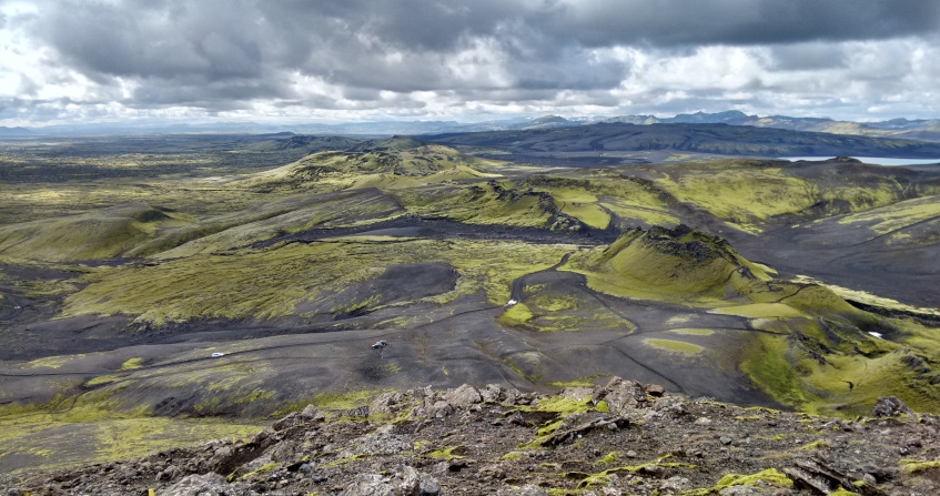
In 1783, a mysterious dry fog enveloped the continent of Europe, blood-red sunsets were reported throughout the summer, and many reported a sulfuric smell, breathing difficulties and sore eyes. The Europeans were unaware that this was the result of a devastating event unfolding in Iceland. Many other phenomena were recorded throughout the year, including earthquakes and unusually frequent thunderstorms, leading to 1783 being dubbed an annus mirabilis, a year of awe. What could have caused these phenomena? Could these phenomena possibly all be connected?
1. Iceland—The land of ice and fire
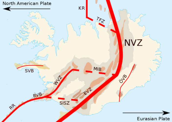
Iceland is often referred to as a land of “ice and fire.” It’s home to many volcanoes and, due to its location in the North Atlantic and its proximity to the Arctic Circle several glaciers. Geologically speaking, Iceland is very young. It formed over the past 24 million years, due mainly to two geological phenomena: Firstly, the fact that it is located at a diverging plate boundary, also known as a constructive plate boundary, as new crust is created here by the Mid-Atlantic Ridge. Iceland, perched upon both the Eurasian plate and the North American plate (Figure 1), grows by about two centimeters a year, one centimeter to the east and one to the west. Secondly, that it is located on top of a mantle plume, which is also known as a hot spot: A mass of relatively hot and therefore less dense mantle materials rise up from the Earth’s mantle towards the surface where it produces volcanism.
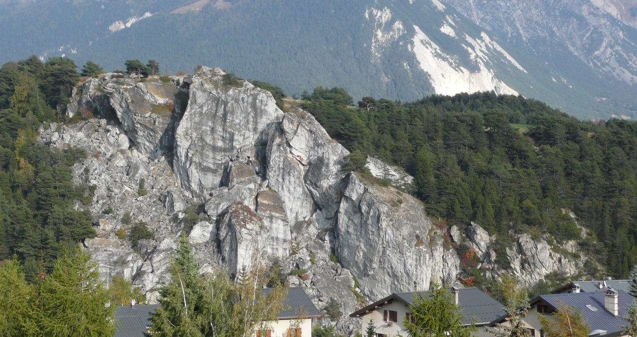
This volcanic eruption is known by many names: Its Icelandic name, Skaftareldar, comes from the fact that the eruption took place in the Skaftarfellssysla, a region of Iceland, and that it replaced the Skaftá with lava. The crater row is also known as Lakagígar, meaning the craters of Laki. The name Laki comes from Mount Laki, a mountain of volcanic origin that did not actually erupt in 1783, located roughly in the middle of the fissure (Figure 4). In English, the eruption is mainly known as the Laki Fissure eruption. The term “Laki” was suggested by Norwegian geologist Amund Helland almost one hundred years after the eruption, it was also chosen for its brevity and easiness to pronounce. Sometimes, it is also referred to as the Laki eruption.
2. The course of the eruption and the consequences for Iceland
This lava threatened many Icelanders, their animals, and property. A small number of churches and farmsteads fell victim to the lava. Icelanders were able to evacuate before the lava arrived. A very important local chronicler, who kept records on the events unfolding in Kirkjubæjarklaustur and what he could observe from a distance about what was happening in the highlands, is Jón Steingrímsson. He was a local reverend. He became famous for his autobiography and his “fire treatise,” that described the events, and is well known as the “fire priest.” On July 20, 1783, lava crept to within a few meters of his church, in Kirkjubæjarklaustur, as he began mass. After his sermon, known as the “fire sermon,” the parishioners were astonished to find the lava in the same spot where it had been when mass began. Steingrímsson, it seemed to his parishioners, had prevented the lava from engulfing and consuming the church.
The eruption had produced large amounts of gases and ash too. The gases, particularly the fluorine, poisoned the fields, meadows, and ponds. 50% of all the cattle, 79% of the sheep, and 76% of the horses perished between 1783 and 1785, in addition to fish in ponds and other animals [5]. In Iceland, the eruption is also remembered by its consequence: The famine of the mist, or Móðuharðindin. The Icelandic diet at the time was mainly based on meat and fish, so the fallout of this eruption was catastrophic. By 1785, roughly 20 percent of the Icelandic population had perished—from hunger, malnutrition, or diseases.
Iceland was under a Danish trade monopoly, which meant that only certain Danish merchants were allowed to trade with Iceland at specific trading posts around the country. Usually, these merchants arrived in the spring and left in late summer or early autumn. News about the volcanic eruption reached Copenhagen in early September 1783, and so, the Danish king, Christian VII, decided to send a party to Iceland to survey the damage caused by the eruption. However, due to adverse weather conditions, the surveyors did not arrive until the spring of 1784. It took until the 1810s for the population in Iceland to get back to its pre-1783 levels.[6]
3. Impacts on the world outside of Iceland
3.1. Extraordinary weather phenomena and signs in the sky
What makes this eruption so extraordinary is that its impacts reached far beyond the borders of Iceland. The gas was transported to Europe via the jet stream, where it became observable as a sulfuric-smelling dry fog. The contemporaries in Europe were oblivious to the fact that a volcanic eruption had occurred in Iceland at the same time and was causing this unusual dry fog. The most worrisome feature of the summer of 1783 was perhaps the “blood red” coloring of the sun during sunset and sunrise. Stars and planets became invisible in the lower degrees above the horizon—very similar to the appearance of smog in large cities today.
In 2010, when Eyjafjallajökull erupted, the world was reminded of Icelandic volcanism and its almost global consequences: The plume of ash and gas was carried from Iceland towards Europe via the jet stream, grounding international air traffic for several days. Even before the onset of international aviation, Icelandic volcanic eruptions proved troublesome for the outside world.
Several extraordinary weather phenomena occurred throughout 1783—the annus mirabilis, the year of awe. Among them, a sulfuric-smelling dry fog that lasted for several weeks and that was observable from around June 16 in most parts of Europe and beyond. It was visible as far away as Labrador in today’s Canada, Syria, the Lebanon, and even the Altai Mountains on the border to China. [9] It varied in density, winds from the northwest seemed to strengthen it, whereas winds from the south seemed to disperse it. During the summer of 1783, the contemporaries in Europe were left alone to speculate about the fog’s origin.
The dry fog was mainly caused by sulfur dioxide (SO2) that had been released during the eruption, the gases are believed to have reached an altitude of 9-12 kilometers. Above Iceland, the tropopause is at approximately 8-11 kilometers of altitude. The lower level of the atmosphere is called the troposphere and the level above is called the stratosphere. Generally, if volcanic gases only reach the troposphere, they are washed out within weeks and there is no long-term impact on the climate. If volcanic gases reach the stratosphere, they will remain in the atmosphere for longer and have lasting impacts on the climate, perhaps for up to three years. Scientists working on the Laki Fissure eruption are divided on whether most of the Laki gases were able to reach the stratosphere. Once the sulfur dioxide reached the tropospause, it was transported towards Europe via the polar jet stream, here the sulfur dioxide chemically reacted with the moisture, which produced sulfuric acid (H2SO4). An unusual anticyclonic weather pattern above Europe, a quasi-stationary high-pressure cell, funneled the Laki gases down to the surface level, where it materialized as a sulfuric-smelling dry fog. [10]
In addition, the summer of 1783 was hot in north, west, and central Europe. This is particularly unusual, as normally cooling is expected after a large volcanic eruption. The heat wave was most likely related to this high-pressure cell. [11]
The dry fog was peculiar, long-lasting, and may have had some negative impacts on vegetation and human health in mainland Europe. A sticky substance was said to have formed on leaves of plants, it was called “honey dew.” Particularly around June 24-25, in the Netherlands and Northwest Germany, almost over night, plants were heavily affected. Several plants withered, leaves changed their color or the trees lost their leaves altogether, but not all species were affected the same. At the same time, chemical reactions on metal were observed, structures rusted or turned green. The dry fog hit hardest those suffering from pre-existing respiratory or heart issues. In several regions, people complained about sore eyes. There are studies for England and France that analyze whether the heat, the dry fog, or several factors together may have caused a higher than usual mortality rate in the population. It remains unclear if it was indeed this fog that caused this, or an unrelated outbreak of another kind.
Other contemporary reports argued against the fear mongering: Reports from the eldest community members and close study of older chronicles suggested that similar events had occurred in the past and they were always followed by fertile years, indicating that there was nothing to worry about. Indeed, the grape harvest of 1783 seemed to have been extraordinarily successful, most likely aided by the very warm summer.
The summer also saw a large number of severe thunderstorms, which brought with them frequent lightning that killed many people. The practice of ringing church bells to reroute the storm clouds when thunderstorms were approaching undoubtedly helped those figures (clocher de tourmente in French). The recent invention of the lightning rod and a sudden increase in their popularity throughout the summer of 1783, led to a law abolishing this practice in many regions [12].
3.2. Speculation about the cause of the unusual weather
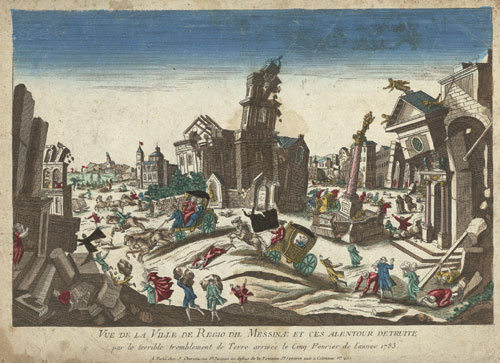
By far the most popular explanation for the presence of the dry fog was the numerous earthquakes that seemed to have occurred throughout the year: In February and March 1783, a seismic sequence of five very strong earthquakes shook Sicily and Calabria, causing an estimated 30,000 casualties (Figure 6).[13] Other earthquakes occurred throughout the summer: On July 6, an earthquake shook parts of France, and was felt in Franche-Comté, the Jura, Burgundy, and Geneva. This earthquake did not produce much damage, but it occurred when the dry fog was still dense and wide-spread. Another earthquake occurred on the night from August 7 to 8, affecting Northern France, and the areas between Aachen and Maastricht. Another major earthquake hit Tripoli, Lebanon, on July 30. [14] Many contemporaries believed they were living in a time of “subterraneous revolution” and there were reports of a “newly emerged burning island” that was discovered by fishermen in May 1783 off the coast of Iceland. This island was said to have been emitting smoke and surrounded by pumice, floating on the ocean surface, impeding sea travel. This island was called Nyey (“new island”) and was fussed over in the news during the summer and almost forgotten by the time continental Europe heard of the Laki Fissure eruption. [15]
There also were reports of “fire spitting mountains” that had erupted in three different parts of Germany: The most famous one being the Gleichberg in Thuringia. The reports were surprisingly accurate in describing the process of a volcanic eruption and it is debatable whether these were genuine explanation attempts to describe the origin of the dry fog locally or whether they were clever hoaxes to spread fear. [16] The reports were later retracted after people had visited these areas only to realize the extinct volcanoes hadn’t inexplicably sprung back to life. The idea of volcanic eruptions, though, fit very well with the above-mentioned theory of a subterraneous revolution.

While the debate about the origin of the dry fog was primarily inspired by the Enlightenment and the thirst for a rational explanation, there also were some religious arguments made.
3.3. Speculation about a connection between the dry fog and icelandic volcanism
A handful of contemporary naturalists considered a connection between the dry fog and volcanic eruptions in Iceland. Most suggested that there might be a connection between the unusual weather phenomena of the summer and either the Nyey eruption or the eruption in the Skaftárfellsysla region when they learnt about them in the news in early to mid-September of 1783. The first to propose such an idea was Jacques Antoine Mourge de Montredon, a French naturalist, who presented his findings in front of the Société Royale des Sciences de Montpellier on August 7, 1783. Christian Gottlieb Kratzenstein, a German naturalist and professor for physics at the University of Copenhagen also connected Icelandic volcanism, with which he was familiar, with the dry fog. Swiss naturalist H. Guerin also came to a similar conclusion, his findings were published in Neue Zürcher Zeitung on November 5, 1783. Johann Rudolf von Salis-Marschlins, also a Swiss naturalist, published his findings on the topic in Der Sammler: Eine gemeinnützige Wochenschrift für Büntgen in mid-November 1783. Belgian botanist and baron Eugène de Poederlé published a text about his observations made in Brussels in early 1784.
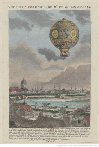
In May 1784, Benjamin Franklin, who had suggested the dry fog might have been caused by the meteor, also suggested alternatively that Icelandic volcanoes—either Nyey or Hekla—might have been responsible. [21] However, all this speculation remained just that for a long time.
4. The search for the origin of the dry fog
When the news of an Icelandic volcanic eruption reached Denmark, the mystery about the dry fog was not lifted. It was only in 1794, that Icelandic naturalist and physician Sveinn Pálsson discovered the Laki Fissure in the highlands. Pálsson described his discovery in his manuscript, which he sent to Copenhagen, but remained unpublished for financial reasons. In 1879, Icelandic geologist Thorvaldur Thoroddsen stumbled upon the manuscript at the Royal Library in Copenhagen and subsequently published part of it in 1879. Norwegian geologist Amund Helland also took an interest in this and upon Thoroddsen’s suggestion visited the Laki Fissure in 1881, he also drew a map of the craters and lava fields. Thoroddsen visited the fissure in 1894. [22]
In 1883, another volcanic eruption made global news: In the Dutch East Indies, a volcano called Krakatau produced the loudest noise ever recorded, ejected large amounts of gas and ash, and triggered a tsunami. The eruption is estimated to have killed 35,000 people. Despite Krakatau’s distance from Europe, the news about the eruption spread fast–thanks to the advent of telegraphy. [23]
This large volcanic eruption inspired several scientists into action, who collected information from professional and amateur weather observers from all around the world. They realized for the first time that volcanic eruptions can have impacts on the sky and weather phenomena far, far away from the actual volcano. In the aftermath of the 1883 Krakatau eruption, colorful sunsets and vibrant colors of the sky were observed in Europe and North America. Thus, in the 1880s, the dots between the Laki Fissure eruption and the strange haze of the summer of 1783 could finally be connected. [24]
5. The Laki Fissure today
The Vatnajökull National Park was established in 2008 and now also incorporates the Laki Fissure (Figure 10). The increase in tourism to Iceland also leads to an increasing number of visitors to the fissure. The Laki Fissure is difficult to reach. From Kirkjubæjarklaustur it is an eight hour round trip on a four-wheel bus. Although only 50 kilometers from the village, traversing bumpy dirt roads, kn

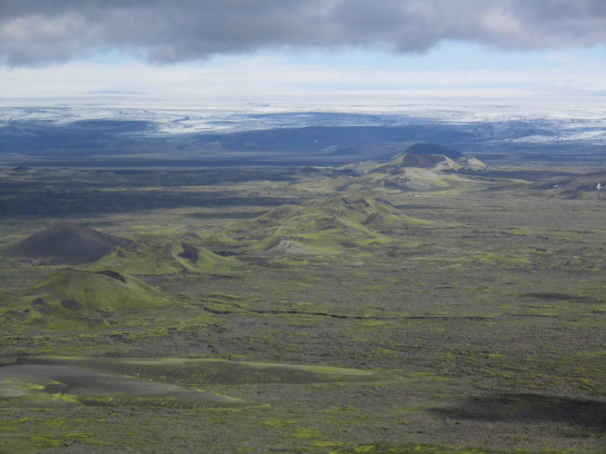
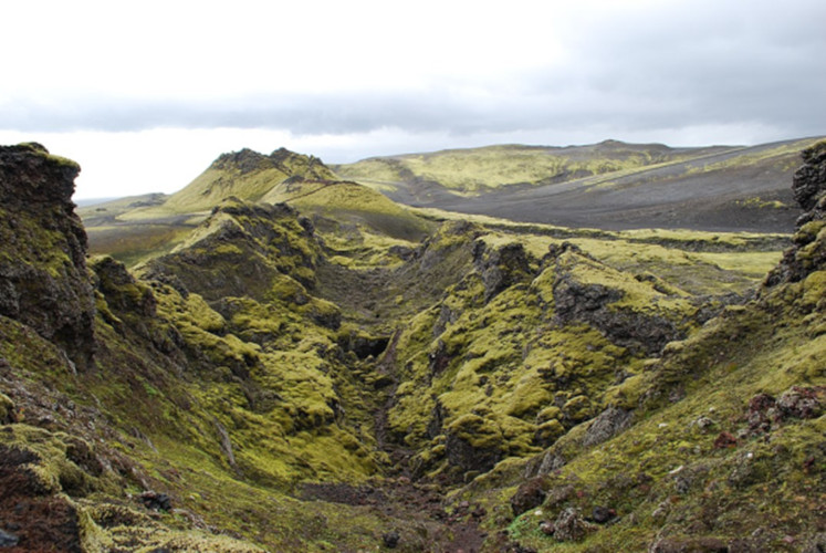
Sadly, not all tourists respect nature, some leave rubbish behind and others leave the designated pathways. On the Skaftáreldahraun, the Laki lava field, a very delicate sort of moss is growing, painting the hills around the Laki Fissure with a lush light green (Figure 11). This moss, due to the altitude and high latitudes, is very sensitive and takes decades to grow. If it is stepped on, it turns brown and dies. Several warning signs educate visitors and the efforts of volunteer conservationists have led to wooden paths being built that visitors can step on. [26]
Large flood lava events such as the Laki Fissure eruption have a recurrence time of 300-1000 years. However, in Iceland, the next volcanic eruption is never far away: On average, Iceland sees a volcanic eruption every 3-5 years. Today, Iceland monitors its volcanoes carefully and gives locals and travelers a warning to evacuate once the threat of a volcanic eruption is imminent. It is important to understand the consequences of Icelandic volcanic eruptions on Europe and the northern hemisphere so that we may act accordingly in the future.
6. Messages to remember
- The Laki Fissure eruption of 1783 shows that volcanic eruptions can have impacts on regions far away from the actual volcano.
- Sometimes, these effects might be fairly long lasting, even perturbing weather patterns to the extreme.
- This extreme event during the Little Ice Age shows how contemporaries dealt with sudden and extreme weather changes, these lessons may become very useful in our own present and future in a warming world.
Notes et références
Cover image. The southwestern part of the Laki Fissure in Iceland, as seen from Mount Laki. [Source: Photo © Katrin Kleemann. (Used by permission).]
[1] Thorvaldur Thordarson and Armann Höskuldsson. Iceland. Edinburgh: Dunedin, 2014.
[2] Thordarson, Thorvaldur, and Self, Stephen. “The Laki (Skaftar Fires) and Grimsvotn eruptions in 1783-1785.” Bulletin of Volcanology 55 (1993), 233–263.
[3] Thordarson, Thorvaldur, and Self, Stephen. “Atmospheric and environmental effects of the 1783–1784 Laki eruption: A review and reassessment.” Journal of Geophysical Research 108 (2003).
[4] Steingrímsson, Jón. Fires of the Earth. The Laki Eruption 1783-1784, translated by Keneva Kunz, 25-26. Reykjavík: University of Iceland Press and Nordic Volcanological Institute, 1998.
[5] Oppenheimer, Clive. Eruptions that Shook the World. Cambridge: Cambridge University Press, 2011.
[6] Vasey, Daniel E. “Population, Agriculture, and Famine: Iceland, 1784-1785.” Human Ecology 19, no. 3 (1991): 323-350.1810: 49,000 inhabitants; 1815: 50,000 inhabitants. (accessed on 19 April 2019)
[7] Gillespie, Richard. “Ballooning in France and Britain, 1783-1786. Aerostation and Adventurism.” ISIS 75, no 2 (1984): 249-268.
[8] The term “Ballomania” was used in letter by Joseph Banks to Benjamin Franklin, November 7, 1783. Van Pelt Library, University of Pennsylvania, VIII, p. 35.
[9] Stothers, Richard. “The Great Dry Fog of 1783.” Climatic Change 32, no. 1 (1996): 79-89.
[10] Thordarson, Thorvaldur, and Stephen Self. “Real-Time Observations of the Laki Sulfuric Aerosol Cloud in Europe During 1783 as Documented by Professor S. P. van Swinden at Franeker, Holland.” Jökull 50 (2011): 65-72.
[11] Zambri, Brian, Alan Robock, Michael J. Mills, and Anja Schmidt. “Modelling the 1783-1784 Laki Eruption in Iceland, Part II: Climate Impacts.” JGR Atmospheres 2019.
[12] Hochadel, Oliver, “‘In Nebula Nebulorum’: The Dry Fog of the Summer of 1783 and the Introduction of Lightning Rods in the German Empire,” Transactions of the American Philosophical Society 99, no. 5 (2009): 45–70.
[13] Kleemann, Katrin. “Living in the Time of a Subsurface Revolution: The 1783 Calabrian Earthquake Sequence.” Environment & Society Portal, Arcadia (Summer 2019), no. 30. Rachel Carson Center for Environment and Society.
[14] Demarée, Gaston R., and Astrid E. J. Ogilvie. “Bons Baisers d’Islande: Climatic, Environmental, and Human Dimension. Impacts of the Lakagigar Eruption (1783-1784) in Iceland.” In History and Climate: Memories of the Future, edited by R. D. Jones. et al., 219-246. New York: Springer, 2001.
[15] Kleemann, Katrin. “Living in the Time of a Subsurface Revolution: The 1783 Calabrian Earthquake Sequence.” Arcadia: Explorations in Environmental History, Summer Volume 2019, forthcoming.
[16] Grattan, John, David D. Gilbertson, and A. Dill, “‘A Fire Spitting Volcano in our Dear Germany’: Documentary Evidence for a Low-Intensity Volcanic Eruption of the Gleichberg in 1783?” The Archaeology of Geological Catastrophe [Geological Society London, Special Publications] 171 (2000): 307–15.
[17] Beech, Martin. „The Great Meteor of 18th August 1783.” Journal of the British Astronomical Association 99, no. 3 (1989): 130-134.
Payne, Richard J. “Meteors and Perceptions of Environmental Change in the annus mirabilis AD1783-4.” North West Geography 11, no. 1 (2011): 19-28.
[18] Brazdil, Rudolf, Gaston R. Demarée, Mathias Deutsch, et al. “European Floods During the Winter 1783/1784: Scenarios of an Extreme Event During the ‘Little Ice Age’.” Theoretical and Applied Climatology 100, no. 1-2 (2010): 163-189. Demarée, Gaston R. “The Catastrophic Floods of February 1784 in and around Belgium—a Little Ice Age Event of Frost, Snow, River Ice … and Floods.” Hydrological Sciences Journal 51, no. 5 (2006): 878-898.
[19] Ludlum, David M. Early American Winters (1604 to 1820), volumes I and II. American Meteorological Society: Lancaster Press, 1968.
[20] Dwight L. Smith, “Josiah Harmar, Diplomatic Courier.” Pennsylvania Magazine of History and Biography 87.4 (1963): 420–430.
[21] Demarée, Gaston R, and Astrid E. J. Ogilvie. “L’éruption du Lakagígar en Island ou ‘Annus mirabilis 1783’. Chronique d’une année extraordinaire en Belgique et allieurs.” In Études et bibliographies d’histoire environnementale. Belgique – Nord de la France – Afrique centrale, edited by Isabelle aprmentier. Actes des 2e RBel, Namur, 2016.
[22] Helland, Amund. Lakis kratere og lavastrømme. Kristiania: Trykt I Centraltrykkeriet, 1886.
Thoroddsen, Th. “De vulkanske Udbrud paa Island I Aaret 1783.” Geografisk Tidskrift 1879.
[23] Winchester, Simon. Krakatoa. The Day the World Exploded. 27th August 1883. London: Viking, 2003.
[24] Symons, George, et al., The Eruption of Krakatoa, and Subsequent Phenomena. London: Harrison and Sons, 1888.
[25] Planning your visit to Laki
[26] Kleemann, Katrin. “Watch your Step! Moss Conservation in Vatnajökull National Park, Iceland.” Seeing the Woods, 18 October 2016.
The Encyclopedia of the Environment by the Association des Encyclopédies de l'Environnement et de l'Énergie (www.a3e.fr), contractually linked to the University of Grenoble Alpes and Grenoble INP, and sponsored by the French Academy of Sciences.
To cite this article: KLEEMAN Katrin (January 5, 2025), The Laki Fissure eruption, 1783-1784, Encyclopedia of the Environment, Accessed July 23, 2026 [online ISSN 2555-0950] url : https://www.encyclopedie-environnement.org/en/society/laki-fissure-eruption-1783-1784-2/.
The articles in the Encyclopedia of the Environment are made available under the terms of the Creative Commons BY-NC-SA license, which authorizes reproduction subject to: citing the source, not making commercial use of them, sharing identical initial conditions, reproducing at each reuse or distribution the mention of this Creative Commons BY-NC-SA license.