The Laki Fissure eruption, 1783-1784

PDF

In 1783, a mysterious dry fog enveloped the continent of Europe, blood-red sunsets were reported throughout the summer, and many reported a sulfuric smell, breathing difficulties and sore eyes. The Europeans were unaware that this was the result of a devastating event unfolding in Iceland. Many other phenomena were recorded throughout the year, including earthquakes and unusually frequent thunderstorms, leading to 1783 being dubbed an annus mirabilis, a year of awe. What could have caused these phenomena? Could these phenomena possibly all be connected?

1. Iceland—The land of ice and fire

iceland - iceland map - tectonic plates iceland
Figure 1. Iceland’s location on two tectonic plates. The location of the Mid-Atlantic Ridge is shown here as a bold red line. The major volcanic zones are also indicated. [Source: Psiĥedelisto (add fault lines), Chris.urs-o (iceland outline) [CC BY-SA (https://creativecommons.org/licenses/by-sa/3.0)]
On June 8, 1783, it began. In the highlands in southeastern Iceland, a volcano erupted. A 27-kilometer-long fissure tore through the landscape, beginning an eruption, which would last until February 7, 1784.

Iceland is often referred to as a land of “ice and fire.” It’s home to many volcanoes and, due to its location in the North Atlantic and its proximity to the Arctic Circle several glaciers. Geologically speaking, Iceland is very young. It formed over the past 24 million years, due mainly to two geological phenomena: Firstly, the fact that it is located at a diverging plate boundary, also known as a constructive plate boundary, as new crust is created here by the Mid-Atlantic Ridge. Iceland, perched upon both the Eurasian plate and the North American plate (Figure 1), grows by about two centimeters a year, one centimeter to the east and one to the west. Secondly, that it is located on top of a mantle plume, which is also known as a hot spot: A mass of relatively hot and therefore less dense mantle materials rise up from the Earth’s mantle towards the surface where it produces volcanism.

iceland map - fissure laki iceland
Figure 2. Iceland and the location of the Laki Fissure, indicated by a red line to the SW of Vatnajökull. [Source:Max Naylor [Public domain]]
Iceland is divided into various volcanic zones, which make up a third of Iceland’s landmass (Figure 1). It is further divided into thirty volcanic systems, with a wide range of different volcano types. The Laki fissure eruption is located in a system called Grímsvötn. Grímsvötn is Iceland’s most productive volcanic system, fed by a central volcano of the same name that is located underneath the Vatnajökull ice shield. This system on average produces one volcanic eruption every 2-7 years. [1]

Figure 3. The delta of the Skaftá river in southern Iceland. [Source: Bjoertvedt [CC BY-SA (https://creativecommons.org/licenses/by-sa/3.0)]]
This volcanic eruption produced 14.7 cubic kilometers of lava. [2] The event was composed of ten eruptive episodes, each one beginning with strong earthquakes, followed by explosive activity, resulting in a new fissure segment. The entire fissure consists of around 140 craters, vents, and cones in a SW-NE direction, all the way to the Vatnajökull ice sheet, Iceland’s largest glacier (Figure 2). The total amount of lava produced covers an area of 599 square kilometers. [3]

laki - laki fissure - laki mount
Figure 4. The NE part of the Laki Fissure, as seen from Mount Laki. In the distance, Vatnajökull is visible, Iceland’s largest glacier. [Source: Photo © Katrin Kleemann]
The fissure is located at around 600 meters above sea level, whereas the coastal areas are much lower. Kirkjubæjarklaustur, a settlement on the southeastern coast, is located at 35 to 40 meters above sea level. So naturally, the large volumes of lava travelled downhill towards the coastal plains. The lava travelled, for the most part, via river beds, mainly through the Skaftá and Hversfljót, two glacial rivers that normally flow from Vatnajökull to the Atlantic Ocean. Skaftá (Figure 3), was devoid of water, lava lay in its stead. [4]

This volcanic eruption is known by many names: Its Icelandic name, Skaftareldar, comes from the fact that the eruption took place in the Skaftarfellssysla, a region of Iceland, and that it replaced the Skaftá with lava. The crater row is also known as Lakagígar, meaning the craters of Laki. The name Laki comes from Mount Laki, a mountain of volcanic origin that did not actually erupt in 1783, located roughly in the middle of the fissure (Figure 4). In English, the eruption is mainly known as the Laki Fissure eruption. The term “Laki” was suggested by Norwegian geologist Amund Helland almost one hundred years after the eruption, it was also chosen for its brevity and easiness to pronounce. Sometimes, it is also referred to as the Laki eruption.

2. The course of the eruption and the consequences for Iceland

This lava threatened many Icelanders, their animals, and property. A small number of churches and farmsteads fell victim to the lava. Icelanders were able to evacuate before the lava arrived. A very important local chronicler, who kept records on the events unfolding in Kirkjubæjarklaustur and what he could observe from a distance about what was happening in the highlands, is Jón Steingrímsson. He was a local reverend. He became famous for his autobiography and his “fire treatise,” that described the events, and is well known as the “fire priest.” On July 20, 1783, lava crept to within a few meters of his church, in Kirkjubæjarklaustur, as he began mass. After his sermon, known as the “fire sermon,” the parishioners were astonished to find the lava in the same spot where it had been when mass began. Steingrímsson, it seemed to his parishioners, had prevented the lava from engulfing and consuming the church.

The eruption had produced large amounts of gases and ash too. The gases, particularly the fluorine, poisoned the fields, meadows, and ponds. 50% of all the cattle, 79% of the sheep, and 76% of the horses perished between 1783 and 1785, in addition to fish in ponds and other animals [5]. In Iceland, the eruption is also remembered by its consequence: The famine of the mist, or Móðuharðindin. The Icelandic diet at the time was mainly based on meat and fish, so the fallout of this eruption was catastrophic. By 1785, roughly 20 percent of the Icelandic population had perished—from hunger, malnutrition, or diseases.

Iceland was under a Danish trade monopoly, which meant that only certain Danish merchants were allowed to trade with Iceland at specific trading posts around the country. Usually, these merchants arrived in the spring and left in late summer or early autumn. News about the volcanic eruption reached Copenhagen in early September 1783, and so, the Danish king, Christian VII, decided to send a party to Iceland to survey the damage caused by the eruption. However, due to adverse weather conditions, the surveyors did not arrive until the spring of 1784. It took until the 1810s for the population in Iceland to get back to its pre-1783 levels.[6]

3. Impacts on the world outside of Iceland

3.1. Extraordinary weather phenomena and signs in the sky

What makes this eruption so extraordinary is that its impacts reached far beyond the borders of Iceland. The gas was transported to Europe via the jet stream, where it became observable as a sulfuric-smelling dry fog. The contemporaries in Europe were oblivious to the fact that a volcanic eruption had occurred in Iceland at the same time and was causing this unusual dry fog. The most worrisome feature of the summer of 1783 was perhaps the “blood red” coloring of the sun during sunset and sunrise. Stars and planets became invisible in the lower degrees above the horizon—very similar to the appearance of smog in large cities today.

In 2010, when Eyjafjallajökull erupted, the world was reminded of Icelandic volcanism and its almost global consequences: The plume of ash and gas was carried from Iceland towards Europe via the jet stream, grounding international air traffic for several days. Even before the onset of international aviation, Icelandic volcanic eruptions proved troublesome for the outside world.

benjamin franklin's terrace passy
Figure 5. The view from Benjamin Franklin’s terrace in Passy on November 21, 1783. This was the first untethered and manned journey of a Montgolfière hot air balloon. Vue de la terrasse de Mr. Franklin a Passi by an anonymous engraver, Paris : Le Vachez : 1783. [Source: Bibliothèque nationale de France, département Estampes et photographie, FOL-IB-1. (In the public domain).]
In early June 1783, two brothers in Annonay, France, had demonstrated the first flight of a hot air balloon (Figure 5). Jacques and Étienne Montgolfier named this new invention in their honor, calling it a Montgolfière. The race to the skies had begun: This would not remain the last balloon to ascend into the skies in France in 1783. Other inventors, such as Anne-Jean Robert, Nicolas-Louis Robert, and Jacques Charles were working on a hydrogen balloon [7]. While the “ballomania[8] took hold, these “flying globes” were not the only unusual phenomenon to occupy the skies and people’s imaginations that year.

Several extraordinary weather phenomena occurred throughout 1783—the annus mirabilis, the year of awe. Among them, a sulfuric-smelling dry fog that lasted for several weeks and that was observable from around June 16 in most parts of Europe and beyond. It was visible as far away as Labrador in today’s Canada, Syria, the Lebanon, and even the Altai Mountains on the border to China. [9] It varied in density, winds from the northwest seemed to strengthen it, whereas winds from the south seemed to disperse it. During the summer of 1783, the contemporaries in Europe were left alone to speculate about the fog’s origin.

The dry fog was mainly caused by sulfur dioxide (SO2) that had been released during the eruption, the gases are believed to have reached an altitude of 9-12 kilometers. Above Iceland, the tropopause is at approximately 8-11 kilometers of altitude. The lower level of the atmosphere is called the troposphere and the level above is called the stratosphere. Generally, if volcanic gases only reach the troposphere, they are washed out within weeks and there is no long-term impact on the climate. If volcanic gases reach the stratosphere, they will remain in the atmosphere for longer and have lasting impacts on the climate, perhaps for up to three years. Scientists working on the Laki Fissure eruption are divided on whether most of the Laki gases were able to reach the stratosphere. Once the sulfur dioxide reached the tropospause, it was transported towards Europe via the polar jet stream, here the sulfur dioxide chemically reacted with the moisture, which produced sulfuric acid (H2SO4). An unusual anticyclonic weather pattern above Europe, a quasi-stationary high-pressure cell, funneled the Laki gases down to the surface level, where it materialized as a sulfuric-smelling dry fog. [10]

In addition, the summer of 1783 was hot in north, west, and central Europe. This is particularly unusual, as normally cooling is expected after a large volcanic eruption. The heat wave was most likely related to this high-pressure cell. [11]

The dry fog was peculiar, long-lasting, and may have had some negative impacts on vegetation and human health in mainland Europe. A sticky substance was said to have formed on leaves of plants, it was called “honey dew.” Particularly around June 24-25, in the Netherlands and Northwest Germany, almost over night, plants were heavily affected. Several plants withered, leaves changed their color or the trees lost their leaves altogether, but not all species were affected the same. At the same time, chemical reactions on metal were observed, structures rusted or turned green. The dry fog hit hardest those suffering from pre-existing respiratory or heart issues. In several regions, people complained about sore eyes. There are studies for England and France that analyze whether the heat, the dry fog, or several factors together may have caused a higher than usual mortality rate in the population. It remains unclear if it was indeed this fog that caused this, or an unrelated outbreak of another kind.

Other contemporary reports argued against the fear mongering: Reports from the eldest community members and close study of older chronicles suggested that similar events had occurred in the past and they were always followed by fertile years, indicating that there was nothing to worry about. Indeed, the grape harvest of 1783 seemed to have been extraordinarily successful, most likely aided by the very warm summer.

The summer also saw a large number of severe thunderstorms, which brought with them frequent lightning that killed many people. The practice of ringing church bells to reroute the storm clouds when thunderstorms were approaching undoubtedly helped those figures (clocher de tourmente in French). The recent invention of the lightning rod and a sudden increase in their popularity throughout the summer of 1783, led to a law abolishing this practice in many regions [12].

3.2. Speculation about the cause of the unusual weather

Figure 6. The earthquake of February 5, 1783. The earthquakes caused severe damage and destruction in Messina (in the foreground) and Reggio Calabria (in the background), killing and injuring thousands of residents. [Source: Public Domain]
The possible explanations for the unusual weather of 1783 were numerous:

By far the most popular explanation for the presence of the dry fog was the numerous earthquakes that seemed to have occurred throughout the year: In February and March 1783, a seismic sequence of five very strong earthquakes shook Sicily and Calabria, causing an estimated 30,000 casualties (Figure 6).[13] Other earthquakes occurred throughout the summer: On July 6, an earthquake shook parts of France, and was felt in Franche-Comté, the Jura, Burgundy, and Geneva. This earthquake did not produce much damage, but it occurred when the dry fog was still dense and wide-spread. Another earthquake occurred on the night from August 7 to 8, affecting Northern France, and the areas between Aachen and Maastricht. Another major earthquake hit Tripoli, Lebanon, on July 30. [14] Many contemporaries believed they were living in a time of “subterraneous revolution” and there were reports of a “newly emerged burning island” that was discovered by fishermen in May 1783 off the coast of Iceland. This island was said to have been emitting smoke and surrounded by pumice, floating on the ocean surface, impeding sea travel. This island was called Nyey (“new island”) and was fussed over in the news during the summer and almost forgotten by the time continental Europe heard of the Laki Fissure eruption. [15]

Figure 7. A map of the Earth’s fire canals (Subterraneus Pyrophylaciorum), which he believed to connect all the volcanoes in the world. This map is from Athanasius Kircher’s Mundus Subterraneus, 1668. [Source: Public Domain]
All of these reports of earthquakes gave credence to the idea of a “subterraneous revolution” connecting the “upheavel” in Iceland, Calabria, and the Lebanon with one another. It was believed that volcanoes around the world were connected by subterraneous canals (Figure 7). There also were reports of a dry fog that occurred just before the first earthquake in Calabria, thus spreading fear that this dry fog might only be a harbinger for a large earthquake that was to come. The idea to connect earthquakes and the dry fog was probably also aided by the fact that the various hundreds of aftershocks in Calabria and Sicily occurred while the dry fog was still visible in southern Italy.

There also were reports of “fire spitting mountains” that had erupted in three different parts of Germany: The most famous one being the Gleichberg in Thuringia. The reports were surprisingly accurate in describing the process of a volcanic eruption and it is debatable whether these were genuine explanation attempts to describe the origin of the dry fog locally or whether they were clever hoaxes to spread fear. [16] The reports were later retracted after people had visited these areas only to realize the extinct volcanoes hadn’t inexplicably sprung back to life. The idea of volcanic eruptions, though, fit very well with the above-mentioned theory of a subterraneous revolution.

henry robinson n accurate representation of the meteor
Figure 8. Henry Robinson, “An accurate representation of the meteor“ as seen at Winthorpe, Nottinghamshire, England, on 18 August 1783. [Source: Henry Robinson / The Trustees of the British Museum. This image is in the online collection of the British Museum. (CC BY-NC-SA 4.0).]
On August 18, 1783, another phenomenon made people turn their heads skyward: A very bright and unusually long-lasting meteor, called “the Great Meteor of 1783” was visible from Ireland, Scotland, England, France, Belgium, and the Netherlands (Figure 8). At the time, an extraterrestrial origin of meteors was not yet widely accepted: There was no clear distinction between meteors and comets. Meteors were believed to be either produced by vapors in the atmosphere or by electricity in the upper atmosphere, similar to the phenomenon of the northern lights. [17] Benjamin Franklin, the American ambassador to the United States, naturalist, and inventor, who was in Paris at the time, speculated whether “the tails of these great burning balls” might have caused the dry fog.

United States delegation at the Treaty of Paris
Figure 9. The United States delegation at the Treaty of Paris: John Jay, John Adams, Benjamin Franklin, Henry Laurens, and William Temple Franklin, as depicted by Benjamin West. The British delegation refused to pose, which is why the painting was never completed. [Source: Benjamin West [Public domain]]
Benjamin Franklin further speculated, in May 1784, that there also was a connection between the dry fog and the extremely cold winter of 1783/1784. The winter had been extraordinarily cold, not only in Europe, but also in North America. In Europe, there was heavy snow, which resulted in major floods along several central and western European rivers in February and March of 1784. In Germany, the water levels of late February 1784 produced the highest or second highest flood markers ever recorded for some regions. [18] In North America, the winter was unusually long, was rich in snow, and even froze the Mississippi river at New Orleans and created ice floes in the Gulf of Mexico. [19] The severe winter conditions made it difficult to assemble enough congress members in Annapolis in order to have a quorum to ratify the Treaty of Paris, which ended the American Revolutionary War (Figure 9). Once the quorum was reached and the treaty was ratified, it was difficult to get a passage across the Atlantic Ocean in order to bring it to Paris to exchange it with the ratified treaty of the British. [20]

While the debate about the origin of the dry fog was primarily inspired by the Enlightenment and the thirst for a rational explanation, there also were some religious arguments made.

3.3. Speculation about a connection between the dry fog and icelandic volcanism

A handful of contemporary naturalists considered a connection between the dry fog and volcanic eruptions in Iceland. Most suggested that there might be a connection between the unusual weather phenomena of the summer and either the Nyey eruption or the eruption in the Skaftárfellsysla region when they learnt about them in the news in early to mid-September of 1783. The first to propose such an idea was Jacques Antoine Mourge de Montredon, a French naturalist, who presented his findings in front of the Société Royale des Sciences de Montpellier on August 7, 1783. Christian Gottlieb Kratzenstein, a German naturalist and professor for physics at the University of Copenhagen also connected Icelandic volcanism, with which he was familiar, with the dry fog. Swiss naturalist H. Guerin also came to a similar conclusion, his findings were published in Neue Zürcher Zeitung on November 5, 1783. Johann Rudolf von Salis-Marschlins, also a Swiss naturalist, published his findings on the topic in Der Sammler: Eine gemeinnützige Wochenschrift für Büntgen in mid-November 1783. Belgian botanist and baron Eugène de Poederlé published a text about his observations made in Brussels in early 1784.

In May 1784, Benjamin Franklin, who had suggested the dry fog might have been caused by the meteor, also suggested alternatively that Icelandic volcanoes—either Nyey or Hekla—might have been responsible. [21] However, all this speculation remained just that for a long time.

4. The search for the origin of the dry fog

When the news of an Icelandic volcanic eruption reached Denmark, the mystery about the dry fog was not lifted. It was only in 1794, that Icelandic naturalist and physician Sveinn Pálsson discovered the Laki Fissure in the highlands. Pálsson described his discovery in his manuscript, which he sent to Copenhagen, but remained unpublished for financial reasons. In 1879, Icelandic geologist Thorvaldur Thoroddsen stumbled upon the manuscript at the Royal Library in Copenhagen and subsequently published part of it in 1879. Norwegian geologist Amund Helland also took an interest in this and upon Thoroddsen’s suggestion visited the Laki Fissure in 1881, he also drew a map of the craters and lava fields. Thoroddsen visited the fissure in 1894. [22]

In 1883, another volcanic eruption made global news: In the Dutch East Indies, a volcano called Krakatau produced the loudest noise ever recorded, ejected large amounts of gas and ash, and triggered a tsunami. The eruption is estimated to have killed 35,000 people. Despite Krakatau’s distance from Europe, the news about the eruption spread fast–thanks to the advent of telegraphy. [23]

This large volcanic eruption inspired several scientists into action, who collected information from professional and amateur weather observers from all around the world. They realized for the first time that volcanic eruptions can have impacts on the sky and weather phenomena far, far away from the actual volcano. In the aftermath of the 1883 Krakatau eruption, colorful sunsets and vibrant colors of the sky were observed in Europe and North America. Thus, in the 1880s, the dots between the Laki Fissure eruption and the strange haze of the summer of 1783 could finally be connected. [24]

5. The Laki Fissure today

center of laki fissure - laki fissure - laki
Figure 10. A photo from the center of the Laki Fissure. [Source: Chmee2/Valtameri [CC BY-SA (https://creativecommons.org/licenses/by-sa/3.0)]
Today, Iceland is an independent country with a population roughly seven times the size it was in 1783. Iceland performs well in many indices that measure quality of life, happiness, and equality. Iceland is far from the marginal country it was 250 years ago. In the last few decades, Iceland has become a popular tourist destination and Iceland is welcoming record numbers of tourists each year. This of course has some environmental consequences.

The Vatnajökull National Park was established in 2008 and now also incorporates the Laki Fissure (Figure 10). The increase in tourism to Iceland also leads to an increasing number of visitors to the fissure. The Laki Fissure is difficult to reach. From Kirkjubæjarklaustur it is an eight hour round trip on a four-wheel bus. Although only 50 kilometers from the village, traversing bumpy dirt roads, kn

eruption laki
Figure 11. The moss on the lava fields that were produced by the 1783-1784 eruption. [Source: Onioram [CC BY-SA (https://creativecommons.org/licenses/by-sa/4.0)]]
own as F-roads, takes time. Additionally, the journey requires the fording of several rivers. [25]

Sadly, not all tourists respect nature, some leave rubbish behind and others leave the designated pathways. On the Skaftáreldahraun, the Laki lava field, a very delicate sort of moss is growing, painting the hills around the Laki Fissure with a lush light green (Figure 11). This moss, due to the altitude and high latitudes, is very sensitive and takes decades to grow. If it is stepped on, it turns brown and dies. Several warning signs educate visitors and the efforts of volunteer conservationists have led to wooden paths being built that visitors can step on. [26]

 Large flood lava events such as the Laki Fissure eruption have a recurrence time of 300-1000 years. However, in Iceland, the next volcanic eruption is never far away: On average, Iceland sees a volcanic eruption every 3-5 years. Today, Iceland monitors its volcanoes carefully and gives locals and travelers a warning to evacuate once the threat of a volcanic eruption is imminent. It is important to understand the consequences of Icelandic volcanic eruptions on Europe and the northern hemisphere so that we may act accordingly in the future.

6. Messages to remember

  • The Laki Fissure eruption of 1783 shows that volcanic eruptions can have impacts on regions far away from the actual volcano.
  • Sometimes, these effects might be fairly long lasting, even perturbing weather patterns to the extreme.
  • This extreme event during the Little Ice Age shows how contemporaries dealt with sudden and extreme weather changes, these lessons may become very useful in our own present and future in a warming world.


Notes et références

Cover image. The southwestern part of the Laki Fissure in Iceland, as seen from Mount Laki. [Source: Photo © Katrin Kleemann. (Used by permission).]

[1] Thorvaldur Thordarson and Armann Höskuldsson. Iceland. Edinburgh: Dunedin, 2014.

[2] Thordarson, Thorvaldur, and Self, Stephen. “The Laki (Skaftar Fires) and Grimsvotn eruptions in 1783-1785.” Bulletin of Volcanology 55 (1993), 233–263.

[3] Thordarson, Thorvaldur, and Self, Stephen. “Atmospheric and environmental effects of the 1783–1784 Laki eruption: A review and reassessment.” Journal of Geophysical Research 108 (2003).

[4] Steingrímsson, Jón. Fires of the Earth. The Laki Eruption 1783-1784, translated by Keneva Kunz, 25-26. Reykjavík: University of Iceland Press and Nordic Volcanological Institute, 1998.

[5] Oppenheimer, Clive. Eruptions that Shook the World. Cambridge: Cambridge University Press, 2011.

[6] Vasey, Daniel E. “Population, Agriculture, and Famine: Iceland, 1784-1785.Human Ecology 19, no. 3 (1991): 323-350.1810: 49,000 inhabitants; 1815: 50,000 inhabitants. (accessed on 19 April 2019)

[7] Gillespie, Richard. “Ballooning in France and Britain, 1783-1786. Aerostation and Adventurism.” ISIS 75, no 2 (1984): 249-268.

[8] The term “Ballomania” was used in letter by Joseph Banks to Benjamin Franklin, November 7, 1783. Van Pelt Library, University of Pennsylvania, VIII, p. 35.

[9] Stothers, Richard. “The Great Dry Fog of 1783.” Climatic Change 32, no. 1 (1996): 79-89.

[10] Thordarson, Thorvaldur, and Stephen Self. “Real-Time Observations of the Laki Sulfuric Aerosol Cloud in Europe During 1783 as Documented by Professor S. P. van Swinden at Franeker, Holland.” Jökull 50 (2011): 65-72.

[11] Zambri, Brian, Alan Robock, Michael J. Mills, and Anja Schmidt. “Modelling the 1783-1784 Laki Eruption in Iceland, Part II: Climate Impacts.” JGR Atmospheres 2019.

[12] Hochadel, Oliver, “‘In Nebula Nebulorum’: The Dry Fog of the Summer of 1783 and the Introduction of Lightning Rods in the German Empire,” Transactions of the American Philosophical Society 99, no. 5 (2009): 45–70.

[13] Kleemann, Katrin. “Living in the Time of a Subsurface Revolution: The 1783 Calabrian Earthquake Sequence.” Environment & Society Portal, Arcadia (Summer 2019), no. 30. Rachel Carson Center for Environment and Society.

[14] Demarée, Gaston R., and Astrid E. J. Ogilvie. “Bons Baisers d’Islande: Climatic, Environmental, and Human Dimension. Impacts of the Lakagigar Eruption (1783-1784) in Iceland.” In History and Climate: Memories of the Future, edited by R. D. Jones. et al., 219-246. New York: Springer, 2001.

[15] Kleemann, Katrin. “Living in the Time of a Subsurface Revolution: The 1783 Calabrian Earthquake Sequence.” Arcadia: Explorations in Environmental History, Summer Volume 2019, forthcoming.

[16] Grattan, John, David D. Gilbertson, and A. Dill, “‘A Fire Spitting Volcano in our Dear Germany’: Documentary Evidence for a Low-Intensity Volcanic Eruption of the Gleichberg in 1783?” The Archaeology of Geological Catastrophe [Geological Society London, Special Publications] 171 (2000): 307–15.

[17] Beech, Martin. „The Great Meteor of 18th August 1783.” Journal of the British Astronomical Association 99, no. 3 (1989): 130-134.
Payne, Richard J. “Meteors and Perceptions of Environmental Change in the annus mirabilis AD1783-4.” North West Geography 11, no. 1 (2011): 19-28.

[18] Brazdil, Rudolf, Gaston R. Demarée, Mathias Deutsch, et al. “European Floods During the Winter 1783/1784: Scenarios of an Extreme Event During the ‘Little Ice Age’.” Theoretical and Applied Climatology 100, no. 1-2 (2010): 163-189. Demarée, Gaston R. “The Catastrophic Floods of February 1784 in and around Belgium—a Little Ice Age Event of Frost, Snow, River Ice … and Floods.” Hydrological Sciences Journal 51, no. 5 (2006): 878-898.

[19] Ludlum, David M. Early American Winters (1604 to 1820), volumes I and II. American Meteorological Society: Lancaster Press, 1968.

[20] Dwight L. Smith, “Josiah Harmar, Diplomatic Courier.” Pennsylvania Magazine of History and Biography 87.4 (1963): 420–430.

[21] Demarée, Gaston R, and Astrid E. J. Ogilvie. “L’éruption du Lakagígar en Island ou ‘Annus mirabilis 1783’. Chronique d’une année extraordinaire en Belgique et allieurs.” In Études et bibliographies d’histoire environnementale. Belgique – Nord de la France – Afrique centrale, edited by Isabelle aprmentier. Actes des 2e RBel, Namur, 2016.

[22] Helland, Amund. Lakis kratere og lavastrømme. Kristiania: Trykt I Centraltrykkeriet, 1886.
Thoroddsen, Th. “De vulkanske Udbrud paa Island I Aaret 1783.” Geografisk Tidskrift 1879.

[23] Winchester, Simon. Krakatoa. The Day the World Exploded. 27th August 1883. London: Viking, 2003.

[24] Symons, George, et al., The Eruption of Krakatoa, and Subsequent Phenomena. London: Harrison and Sons, 1888.

[25] Planning your visit to Laki

[26] Kleemann, Katrin. “Watch your Step! Moss Conservation in Vatnajökull National Park, Iceland.” Seeing the Woods, 18 October 2016.


The Encyclopedia of the Environment by the Association des Encyclopédies de l'Environnement et de l'Énergie (www.a3e.fr), contractually linked to the University of Grenoble Alpes and Grenoble INP, and sponsored by the French Academy of Sciences.

To cite this article: KLEEMAN Katrin (January 14, 2020), The Laki Fissure eruption, 1783-1784, Encyclopedia of the Environment, Accessed July 27, 2024 [online ISSN 2555-0950] url : https://www.encyclopedie-environnement.org/en/society/laki-fissure-eruption-1783-1784/.

The articles in the Encyclopedia of the Environment are made available under the terms of the Creative Commons BY-NC-SA license, which authorizes reproduction subject to: citing the source, not making commercial use of them, sharing identical initial conditions, reproducing at each reuse or distribution the mention of this Creative Commons BY-NC-SA license.

拉基裂缝喷发,1783-1784

PDF

  1783年,一场神秘的干雾笼罩着欧洲大陆,整个夏天都有血红色的日落,许多人说闻到了硫酸的气味并出现了呼吸困难和眼睛疼痛的症状。欧洲人没有意识到这是冰岛发生的灾难性事件所导致的。全年还出现了许多其他现象,包括地震和异常频繁的雷暴,导致1783年被称为奇异之年和令人敬畏之年。是什么造成了这些现象?这些现象之间有联系吗?

1. 冰岛——冰与火之国

环境百科全书-拉基裂缝喷发,1783-1784-冰岛地形
图1. 冰岛位于两大板块交界处。图中大西洋中部海岭的位置由粗红线标出。主要火山带也已标出。[来源:Psiĥedelisto(添加断层线), Chris.urs-o (冰岛概述) [CC BY-SA(https://creativecommons.org/licenses/by-sa/3.0)]

  一切始于1783年6月8日。冰岛东南部的高地上,一座火山爆发了。一条27公里长的裂缝撕开了地面,喷发由此开始,并一直持续到到1784年2月7日。

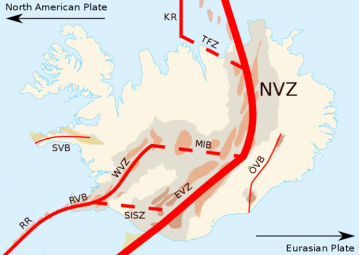
  冰岛常被称为“冰与火”之国。冰岛境内火山众多,由于位于北大西洋,且靠近北极圈,所以还有多座冰川。从地质学上讲,冰岛非常年轻。它形成于2400万年前,主要诞生于两种地质现象:首先,它位于分离板块边界,又名建设性板块边界,大西洋中脊在这里形成了新的地壳。冰岛同时位于欧亚板块和北美板块上(图1),每年以大约两厘米的速度增长,东西各增长一厘米。其次,它位于地幔热柱顶部,即位于所谓热点上:大量温度较高、密度较低的地幔物质从地幔上升到地表引发地表火山活动。

环境百科全书-拉基裂缝喷发,1783-1784-冰岛和拉基裂缝的位置
图2. 冰岛地图和拉基裂缝的位置,如图中Vatnajökull冰原西南端红线所示。[来源:Max Naylor[公有领域]]
环境百科全书-拉基裂缝喷发,1783-1784-冰岛南部Skaftá河的三角洲
图3. 冰岛南部斯卡夫塔河(Skaftá)的三角洲。[来源: Bjoertvedt [CC BY-SA]](https://creativecommons.org/licenses/by-sa/3.0)]]
环境百科全书-拉基裂缝喷发,1783-1784-拉基裂缝的东北部分
图4. 从拉基山上,可以看到拉基裂缝的东北部分。远处可见冰岛最大的冰川Vatnajökull冰川。[来源:图片© 克勒曼·凯特琳]

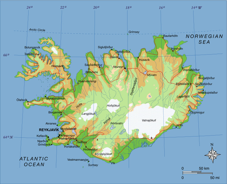
  冰岛被划分为多个火山带,火山带占冰岛陆地面积的三分之一(图1)。火山带可进一步划分为30个火山系,有大量不同的火山类型。拉基裂缝喷发地点位于一个名为Grímsvötn的火山系中。Grímsvötn是冰岛最活跃的火山系,由位于Vatnajökull冰盖下的同名中央火山提供能量。该火山系中的火山平均每2-7年喷发一次[1]

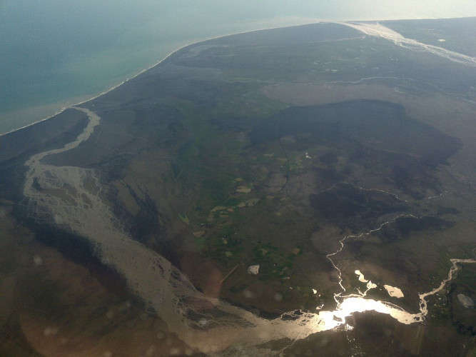
  这次火山喷发产生了14.7立方千米的熔岩[2]。此次喷发包含十次喷发,每次都始于强烈地震,接着出现爆炸活动,从而产生一个新的裂缝段。整个裂缝由大约140个火山口、喷口和西南-东北走向的锥形体组成,一直延伸到冰岛最大的冰川:Vatnajökull冰原(图2)。此次喷发产生的熔岩覆盖总面积达599平方公里[3]

  该裂缝位于海拔600米左右,远高于冰岛沿海地区海拔。Kirkjubæjarklaustur是东南沿海地区的一个定居点,海拔35至40米。因此,大量熔岩自然而然地向沿海平原流动。大部分熔岩是通过河床流动的,主要取道Skaftá和Hversfljót这两条从Vatnajökull流向大西洋的冰川河。Skaftá(图3)当时滴水不剩,完全被熔岩覆盖[4]

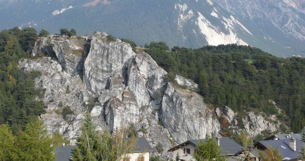
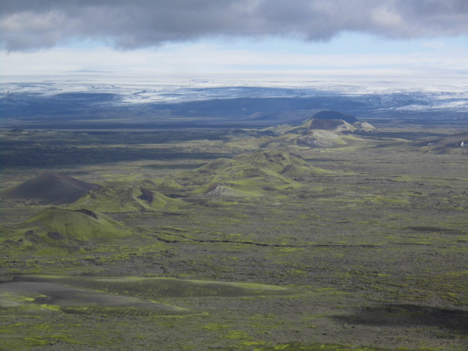
  这场火山喷发有很多名字:它在冰岛语中被称为Skaftareldar,因为发生在冰岛的Skaftarfellssysla地区,Skaftá也被熔岩吞没。火山口群也被称为Lakagígar,意思是拉基火山口。拉基这个名字来自于拉基山,拉基山大约位于拉基裂缝中央,也是火山活动的产物,不过并没有在1783喷发(图4)。在英语中,这次喷发通常被称为Laki Fissure eruption,即拉基裂缝喷发。选择“拉基”一词是挪威地质学家阿蒙德·赫尔兰(Amund Helland)在火山喷发近一百年后提出的,之所以选择这个词,也是因为它简洁易读。有时,它也被称为Laki eruption,即拉基喷发

2. 火山喷发的过程及其对冰岛的影响

  这些熔岩威胁着许多冰岛人、他们的动物和财产。少数教堂和农庄被熔岩摧毁。而冰岛人能够在熔岩到达之前撤离。一位非常著名的当地编年史家约恩·斯坦格里姆松(Jón Steingrímsson记录了Kirkjubæjarklaustur发生的事件,以及他从远处观察到的高地上发生的事情。他也是当地的一名牧师,凭借自传和描述这些事件的“火之协定”成为声名远扬的“火之牧师”。1783年7月20日,当他开始做弥撒时,岩浆流到了离他在Kirkjubæjarklaustur的教堂只有几米远的地方。他的布道被称为“火之布道”,在布道结束后,教区居民惊讶地发现岩浆还停留在弥撒开始时所在的位置。在这些居民看来,斯坦格里姆松阻止了熔岩吞没教堂。

  火山喷发也产生了大量的气体和火山灰。这些气体,尤其是氟,污染了田野、草地和池塘。1783年至1785年间,50%的牛、79%的羊和76%的马死亡,池塘里的鱼和其他动物也受到了类似的影响[5]。在冰岛,火山爆发也带来许多令人刻骨铭心的后果:雾霾中的饥荒,冰岛语写作Móðuharðindin。当时冰岛人的饮食以肉和鱼为主,所以这次火山爆发的后果是灾难性的。到1785年,大约20%的冰岛人死于饥饿、营养不良或疾病。

  冰岛当时处于丹麦的贸易垄断之下,这意味着只有某些丹麦商人被允许在冰岛各地的特定贸易网点与冰岛进行贸易。通常,这些商人在春天到达,在夏末或初秋离开。火山爆发的消息于1783年9月初传到哥本哈根,因此,丹麦国王克里斯蒂安七世决定派一个小组去冰岛调查火山爆发造成的损失。然而,由于恶劣的天气条件,调查人员直到1784年春天才到达。直到1810年左右,冰岛的人口才恢复到1783年前的水平[6]

3. 对冰岛以外世界的影响

3.1. 天空中异常的天气现象和信号

  这次火山喷发的特别之处在于它的影响远远超出了冰岛一国。火山喷发产生的气体通过喷射气流被输送到欧洲,随后变带有硫磺气味的干雾。同时代的欧洲人没有意识到冰岛在这段时间发生了火山爆发,产生了这种不寻常的干雾。1783年夏天最令人担忧的天象可能是日出日落时太阳呈血红色。恒星和行星在地平线上较低的地方就看不见了,和当今大城市的雾霾天很相似。

  2010年Eyjafjallajökull火山爆发提醒了全世界冰岛的火山活动及其全球性的后果:火山灰和气体通过喷射气流从冰岛飘向欧洲,导致国际航班停飞数天。甚至在国际航空业出现之前,冰岛的火山爆发就已经给世界其他地区带来了麻烦。

环境百科全书-拉基裂缝喷发,1783-1784-蒙哥尔菲埃热气球旅程
图5. 1783年11月21日,本杰明·富兰克林在帕西的露台上看到的景色。这是孟格菲热气球的第一次无人驾驶的旅程。《富兰克林先生的土地》,匿名雕刻师,巴黎:勒瓦切兹:1783年。[来源:法国国家图书馆,FOL-IB-1(公共领域)。]

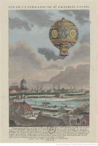
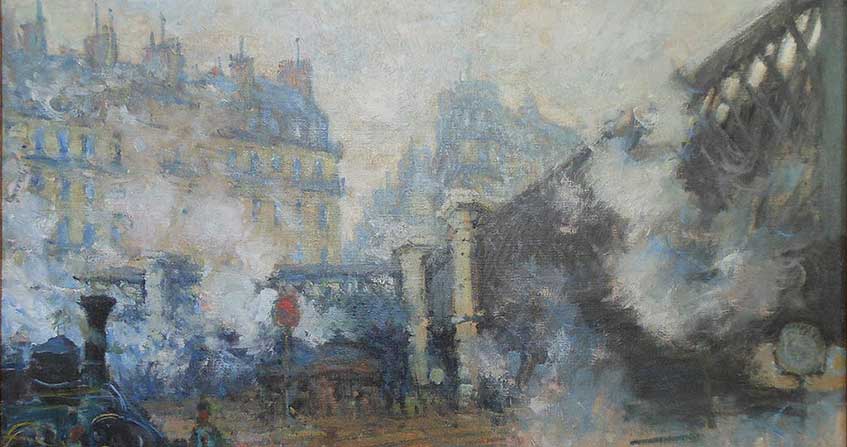
  1783年6月初,法国安诺的两兄弟成功首次将热气球送上了天(图5)。约瑟夫-米歇尔·孟格菲(Joseph-Michel Montgolfier)和雅克-艾蒂安·孟格菲(Jacques-Étienne Montgolfier)将这项新发明以自家姓氏命名,即Montgolfière。飞向天空的竞赛从此开始:这只气球不会是1783年法国升上天空的最后一只。其他发明家,如安妮-让·罗伯特(Anne-Jean Robert)、尼古拉斯-路易斯·罗伯特(Nicolas-Louis Robert)和雅克·查尔斯(Jacques Charles)都在研究氢气球[7]。虽然“气球热潮[8]流行起来,但这些“飞行的球体”并不是那一年占据天空和人们想象力的唯一不寻常现象。

  在整个1783年–这个奇异之年、令人敬畏之年,发生了多次异常的天气现象。其中,一股散发着硫酸味的干雾持续了数周,在6月16日前后,欧洲大部分地区及世界其他地区都有感应。即使远在加拿大的拉布拉多、叙利亚、黎巴嫩、甚至中国边境的阿尔泰山脉都能看到这种干雾。[9]它的密度各不相同,似乎由西北风增强、被南风吹散。1783年夏天的欧洲人只能独自推测雾的来源

  干燥的雾主要是由火山喷发时释放的二氧化硫(SO2)造成的,据悉,这些气体已经达到了9-12公里的高度。在冰岛上空,对流层顶大约在8-11千米的高度。大气层的下层叫做对流层,上层叫做平流层。一般来说,如果火山气体只到达对流层,它们会在几周内被冲刷掉,对气候没有长期影响。如果火山气体到达平流层,它们将在大气中停留更长的时间,并对气候产生持续的影响,或许长达三年。研究拉基裂缝喷发的科学家们对于拉基火山喷发产生的大部分气体是否能够到达平流层存在分歧。一旦二氧化硫到达对流层,它就通过极地急流被输送到欧洲,在这里,二氧化硫与水分发生化学反应,产生硫酸(H2SO4)。欧洲上空一种不寻常的反气旋天气模式,即准静止的高压环流,将拉基裂缝喷发产生的气体向下输送到地面,在地面形成了一种带有硫磺气味的干雾[10]

  此外,1783年的夏天,欧洲北部、西部和中部都很热。这是特别不寻常的,因为通常情况下,在一次大型火山喷发后,气温会下降。这次热浪很可能与这个高压环流有关[11]

  这种干雾奇怪而持久,可能对欧洲大陆的植被和人类健康产生了一些负面影响。据说,植物的叶子上形成了一种粘性物质,叫做“蜜露”。特别是在6月24日至25日前后,荷兰和德国西北部的植物几乎在一夜之间受到了严重影响。众多植物枯萎了,树叶变了颜色,有些树木上的叶子完全掉落,但并非所有植物受到的影响都完全一致。同时人们观察到金属上的化学反应,金属结构生锈或变绿。干雾对那些患有呼吸道或心脏疾病的人影响最大。一些地区的人们总抱怨眼睛疼。英国和法国的一些研究分析了高温、干雾或其他几个因素是否共同导致了人口死亡率高于通常水平。目前还不清楚造成这种死亡率提高的是干雾,还是其他与之无关的因素。

  另一些同时期的报告反对这种制造恐慌的行为:来自最年长社区成员的报告和对更古老编年史的仔细研究表明,类似的事件在过去也发生过,而且紧随其后的总是丰收的年份,表示这没有什么可担心的。事实上,1783年的葡萄产量似乎取得了格外喜人的丰收,很可能是得益于非常温暖的夏季。

  当年夏天还出现了大量严重的雷暴,随之而来的是频繁的闪电,许多人因此丧生。当雷雨来临的时候,人们敲教堂钟来改变暴风云的路线,这种做法无疑帮助了一些人(法语中有个词叫风暴钟楼)。1783年夏天的最新发明避雷针及其迅速普及导致许多地区通过法律废除了这种做法[12]

3.2. 对反常天气原因的猜测

环境百科全书-拉基裂缝喷发,1783-1784-1783年2月5日的地震
图6. 1783年2月5日的地震。地震造成了墨西拿(前景)和雷焦卡拉布里亚(背景)的严重破坏,成千上万的居民伤亡。[来源:公共区域]

  对1783年异常天气的解释有很多版本:

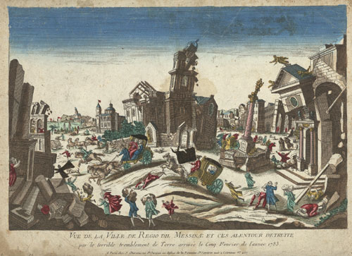
  到目前为止,对干雾存在最流行的解释是,似乎全年发生了多次地震:1783年2月和3月,西西里岛和卡拉布里亚发生了5次强烈地震,造成约3万人伤亡(图6)[13]。在1783年夏天,还有其他地震发生:7月6日,法国部分地区发生地震,弗朗什-孔泰大区、汝拉州、勃艮第大区和日内瓦都有震感。这次地震没有造成太大的破坏,但它发生时干雾恰好浓厚且广布。8月7日至8日夜间也发生了地震,影响法国北部、亚琛和马斯特里赫特之间的地区。7月30日,黎巴嫩的的黎波里又发生了一次大地震[14]。当时许多人认为自己生活在一个“地下革命”的时代,并有报道称,1783年5月,冰岛海岸附近的渔民发现了一座“新出现的燃烧中的岛屿”。 据说这个岛一直在冒烟,被浮石包围着,漂浮在海面上,阻碍了海上航行。这个岛被称为Nyey(“新岛”),在夏天被新闻大肆渲染,但在欧洲大陆听说拉基裂缝喷发后几乎被遗忘[15]

环境百科全书-拉基裂缝喷发,1783-地球上的火运河地图
图7. 地球上的火运河地图(地下火焰兵),作者认为它连接了世界上所有的火山。这张地图来自1668年阿塔纳修斯·基歇尔(Athanasius Kircher)的《地下城》[来源:公共领域]

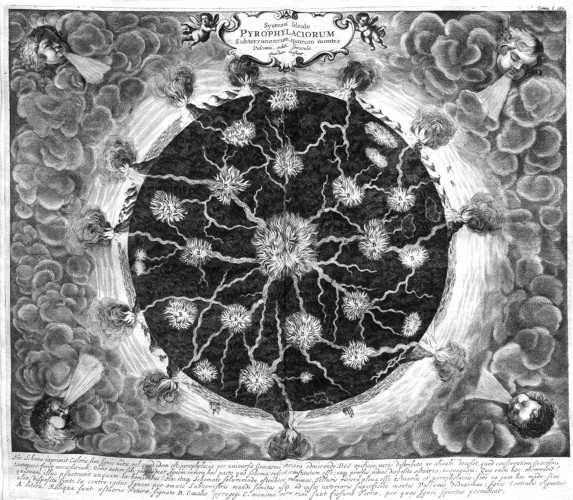
  所有这些关于地震的报道都证实了“地下革命”将冰岛、卡拉布里亚和黎巴嫩的“剧变”相互联系在一起的观点。人们认为,世界各地的火山是由地下运河连接起来的(图7)。还有报道称,就在卡拉布里亚发生第一次地震之前,出现了干雾,因此,人们开始担心,这种干雾可能是一场大地震来临的前兆。把地震和干雾联系起来的想法可能还源于这个事实:当干雾还清晰萦绕在意大利南部时,卡拉布里亚和西西里岛发生了数百次余震。

  还有报道称,德国三个不同地区“喷火山”爆发了:最著名的是图林根州的格莱希堡。这些报告对火山喷发过程的描述惊人地准确。但这些报告究竟是试图描述当地干燥雾起源的真实阐述,还是传播恐惧的自作聪明的恶作剧,仍然存在争议[16]。人们后来实地参访了这些地区后,发现死火山并没有莫名其妙地复活,这些报道就被撤销了。不过,将干雾归因于火山爆发的想法与上文提到的地下革命理论非常吻合。

环境百科全书-拉基裂缝喷发,1783-亨利·鲁宾逊,”对流星的精确描述
图8. 亨利·鲁宾逊(Henry Robinson),“对流星的精确展现” ,1783年8月18日在英格兰诺丁汉郡的温索普所见。[来源:亨利·鲁宾逊/大英博物馆受托人。此为大英博物馆在线馆藏。(CC BY-NC-SA 4.0)。)]

  1783年8月18日,另一种现象让人们抬头仰望天空:在爱尔兰、苏格兰、英格兰、法国、比利时和荷兰都可以看到一颗非常明亮、持续时间非常长、被称为“1783年大流星”的流星(图8)。当时,流星的地外起源还没有被广泛接受:流星和彗星之间还没有明确的区别。流星被认为是由大气中的水蒸气或上层大气中的电流产生的,类似于北极光现象。[17]当时在巴黎的美国大使、博物学家和发明家本杰明·富兰克林推测,或许是“这些巨大的燃烧球体的尾部”产生了干雾

环境百科全书-拉基裂缝喷发,1783-参加巴黎条约的美国代表团
图9. 签署巴黎条约的美国代表团:约翰·杰伊(John Jay)、约翰·亚当斯(John Adams)、本杰明·富兰克林、亨利·劳伦斯(Henry Laurens)和威廉·坦普尔·富兰克林(William Temple Franklin)(由本杰明·韦斯特(Benjamin West)画)。英国代表团拒绝摆姿势,因此右半部分被永远留白。[来源:Benjamin West[公共领域]]

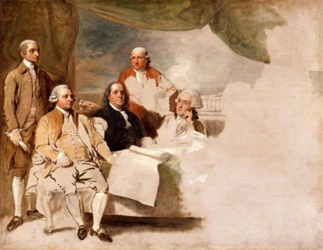
  本杰明·富兰克林在1784年5月进一步推测,干雾与1783和1784年极其寒冷的冬天之间也有联系。当时冬天异常寒冷,不仅欧洲如此,北美也是如此。在1784年的2月和3月,欧洲有一场大雪,导致中欧和西欧的几条河流发生了严重的洪水。在德国,1784年2月下旬的水位产生了一些地区有史以来最高或第二高的记录[18]。在北美,冬天异常漫长,积雪丰富,甚至冻结了新奥尔良的密西西比河,在墨西哥湾形成了浮冰[19]。严酷的冬季条件使得在安纳波利斯很难召集足够国会议员以达到批准结束美国独立战争的《巴黎条约》的法定人数(图9)。尽管达到法定人数,条约被批准,也很难找到一条跨越大西洋的通道,把条约带到巴黎,与英国批准的条约交换[20]

  虽然关于干雾起源的争论主要是受到启蒙运动的启发和对理性解释的渴望,但也不乏一些宗教角度的论点。

3.3. 关于干雾和冰岛火山活动之间联系的猜测

  当时一些博物学家认为冰岛的干雾和火山爆发之间存在联系。当他们在1783年9月上旬至中旬的新闻中得知Nyey或Skaftárfellsysla地区的火山喷发时,大多数人认为夏季的异常天气现象可能与这次火山喷发有关。第一个提出这种想法的是法国博物学家雅克·安托万·莫尔奇·德·蒙特勒顿( Jacques Antoine Mourge de Montredon),他于1783年8月7日在蒙彼利埃皇家科学学会上发表了他的发现。德国博物学家、哥本哈根大学物理学教授克里斯蒂安·戈特利布·克拉岑斯坦(Christian Gottlieb Kratzenstein)也将他所熟悉的冰岛火山活动与干雾联系了起来。瑞士博物学家H.格林(H. Guerin)也得出了类似的结论,他的发现于1783年11月5日发表在《新苏黎世报》上。同为瑞士博物学家的约翰·鲁道夫·冯·萨利斯·马斯林斯(Johann Rudolf von Salis-Marschlins)在1783年11月中旬的《Der Sammle: Eine gemeinnützige Wochenschrift für Büntgen》中发表了他的发现。比利时植物学家和男爵尤金·德·波德尔(Eugène de Poederlé)发表了一篇文章,讲述了他在1784年初在布鲁塞尔所做的观察。

  1784年5月,本杰明·富兰克林提出干雾可能是流星造成的,他还提出冰岛的火山(Nyey火山或Hekla火山)可能是罪魁祸首[21]。然而,在很长一段时间内,所有这些猜测都只是猜测。

4. 寻找干雾的起源

  当冰岛火山喷发的消息传到丹麦时,关于干雾的谜团并没有被解开。直到1794,冰岛博物学家和医生斯韦恩·帕尔森(Sveinn Pálsson才在高地上发现了拉基裂缝。帕尔森在他的手稿中描述了他的发现,他将其寄到了哥本哈根,但由于经济原因一直没有发表。1879年,冰岛地质学家索瓦迪尔·索洛德森(Thorvaldur Thoroddsen)在哥本哈根皇家图书馆偶然发现了这份手稿,并于1879年出版了其中的一部分。挪威地质学家阿蒙德·赫尔兰也对此很感兴趣,在索洛德森的提议下,他于1881年参观了拉基裂缝,并绘制了火山口和熔岩区的地图。索洛德森于1894年访问了这个裂缝[22]

  1883年,另一次火山爆发成为全球焦点:在荷属东印度群岛,一座名为喀拉喀托的火山发出了有史以来最大的巨响,喷出大量气体和火山灰,并引发了海啸。据估计该次喷发造成3.5万人死亡。尽管喀拉喀托火山离欧洲很远,但由于电报的出现,火山喷发的消息传播得很快[23]

  这次大型火山喷发鼓舞了几位科学家采取行动,从世界各地的专业和业余气象观察员那里收集信息。他们第一次意识到火山喷发可以对远离火山的天空和天气现象产生影响。1883年喀拉喀托火山爆发后,欧洲和北美看到了斑斓的日落和鲜艳的天空。因此,19世纪80年代,拉基裂缝爆发和1783年夏天奇怪的雾霾之间的点终于被联系起来了[24]

5. 如今的拉基裂缝

环境百科全书-拉基裂缝喷发,1783-如今的拉基裂缝
图10. 一张来自拉基裂缝中心的照片。[来源: Chmee2/Valtameri [CC BY-SA(https://creativecommons.org/licenses /by-sa/3.0)]

  如今,冰岛是一个独立的国家,人口大约是1783年的7倍。冰岛在许多衡量生活质量、幸福和平等的指标上表现出色,已经不再是250年前那个边缘国家了。在过去一段时间里,冰岛已经成为一个深受欢迎的旅游圣地,每年接待的游客数量都屡创新高。当然,这也会产生一些环境后果。

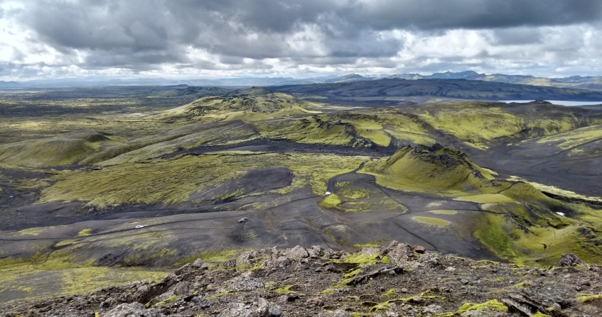
  Vatnajökull国家公园成立于2008年,现在也包含了拉基裂缝(图10)。冰岛旅游业的增长也导致越来越多的游客来到拉基裂缝。拉基裂缝很难到达。从Kirkjubæjarklaustur乘坐四轮公共汽车来回需要8个小时。虽然距离村庄只有50公里,但穿过被称为F路的崎岖不平的土路很花费时间。此外,这趟旅程还需要涉水过河[25]

环境百科全书-拉基裂缝喷发,1783-熔岩上的苔藓
图11. 1783-1784年火山喷发形成的熔岩上的苔藓。[来源: Onioram [CC BY-SA(https://creativecommons.org/licenses/by-sa/4.0)]]

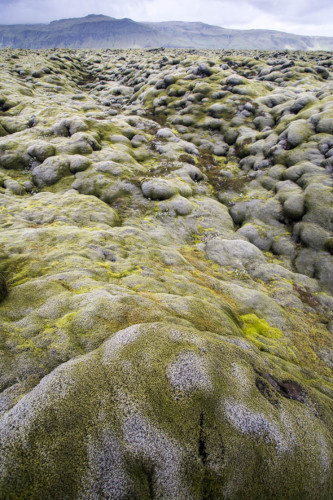
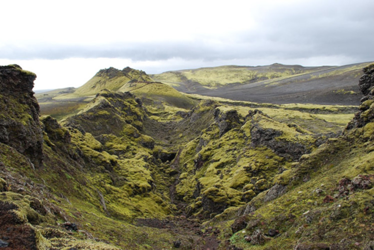
  遗憾的是,并不是所有的游客都尊重自然,有人乱扔垃圾不带走,有些人擅自离开指定的道路。在Skaftáreldahraun的拉基熔岩区,一种非常娇嫩的苔藓正在生长,将拉基裂缝周围的山丘涂成郁郁葱葱的浅绿色(图11)。由于海拔高、纬度高,这种苔藓非常敏感,生长需要几十年。一旦被踩到,就会变成棕色并死去。公园立起了一些警示标志来教育游客,在环保主义志愿者的努力下,公园还为游客修建了可通行的木制小路[26]

  拉基裂缝喷发这样的大型火山喷发两次之间的间隔时间为300-1000年。然而,在冰岛,下一次火山爆发并不会太远:平均冰岛每3-5年就会有一次火山喷发。如今,冰岛对火山进行了仔细的监控,并警告当地人和游客一旦火山爆发的威胁近在眼前就必须撤离。了解冰岛火山爆发对欧洲和北半球的影响是非常重要的,可以让我们在未来采取相应的行动。

6. 总结

  • 1783年拉基裂缝喷发表明,火山喷发会对远离火山的地区产生影响。
  • 有时,这些影响可能是相当持久的,甚至扰乱天气模式,导致极端天气。
  • 小冰期的这一极端事件显示出当代人是如何应对突然而极端的天气变化的,在全球变暖的现在和将来,这些教训可能会非常有用。


参考资料及说明

封面照片:从拉基山上看冰岛拉基裂谷的西南部 [来源:照片©克勒曼·凯特琳。(经许可使用)。]

[1] 索达森,索瓦多,赛尔夫,斯蒂芬。《冰岛》。爱丁堡:但尼丁,2014。

[2] 索达森,索瓦多,赛尔夫,斯蒂芬。“1783-1785年的拉基(斯卡夫塔尔大火)和格里姆火山爆发。”《火山简报》55(1993),233-263。

[3] 索达森,索瓦多,赛尔夫,斯蒂芬。 “1783-1784年拉基火山喷发的大气和环境影响:回顾和重新评估。”《地球物理学报》108(2003)。

[4] Steingrímsson, Jón. 地球之火。拉基火山爆发(1783-1784年) Keneva Kunz译,25-26。Reykjavík:冰岛大学出版社和北欧火山研究所,1998。

[5] 奥本海默,克莱夫。《震撼世界的火山爆发》。剑桥:剑桥大学出版社,2011。

[6] 维西,丹尼尔·E。《人口、农业和饥荒:冰岛,1784-1785》《人类生态学》第19期。3 (1991): 323 – 350.1810: 49000居民;1815: 50000居民。(2019年4月19日生效)

[7] 吉莱斯皮,理查德。1783-1786年法国和英国的热气球。“浮空学和冒险主义”。ISIS 75,第2期(1984):249-268。

[8] 1783年11月7日,约瑟夫·班克斯在给本杰明·富兰克林的信中使用了“狂躁症”一词。宾夕法尼亚大学范佩尔图书馆,第八,第35页。

[9] Stothers,理查德。“1783年的大干雾”《气候变化》,第32期。1(1996): 79 – 89。

[10] 索达森,索瓦多和斯蒂芬·赛尔夫。“1783年欧洲拉基硫酸气溶胶云的实时观测,由荷兰弗兰克尔的 P. 范·斯温登教授记录。”Jökull 50(2011): 65-72。

[11] 赞布里,布莱恩,艾伦·罗博克,迈克尔·J米尔斯,安雅·施密特。”模拟1783-1784年冰岛拉基火山爆发,气候影响一部分。” JGR 大气 2019.

[12] 霍切德,奥利弗,“星云星云:1783年夏的干雾与德意志帝国引进避雷针”《美国哲学学会汇刊》第99期。5(2009): 45 – 70。

[13] 克勒曼,凯特琳。“生活在地下革命的时代:1783年卡拉布里亚地震序列。” 环境与社会门户,阿卡迪亚(2019夏季)。第 雷切尔·卡森环境与社会中心。

[14] Demarée, Gaston R.和Astrid E. J. Ogilvie。“贝瑟斯岛:气候、环境和人类维度冰岛拉基加火山爆发(1783-1784)的影响。”《历史与气候:未来的回忆》 D.琼斯等编辑。219 – 246。纽约:施普林格,2001。

[15] 克勒曼,凯特琳。“生活在地下革命的时代:1783年卡拉布里亚地震序列”阿卡迪亚:环境历史的探索”,夏季卷2019,即将出版。

[16] 格拉坦,约翰,大卫·D吉尔伯森和A·迪尔,“我们亲爱的德国的喷发火山:1783年格莱希伯格火山低强度喷发的文献证据?” 《地质灾害的考古学》[伦敦地质学会,特刊]171(2000):307-15。

[17] 山毛榉,马丁。“1783年8月18日的大流星”《英国天文协会学报》第99期。3(1989): 130 – 134。
佩恩、理查德•J。《公元后1783年第四季度的流星和对环境变化的感知》西北地理11号1(2011):19-28。

[18] 布拉迪尔,鲁道夫,加斯顿 德玛瑞,马赛厄斯·多伊奇,等. “1783/1784年冬季欧洲洪水:小冰期极端事件的情景”《理论与应用气候学》1 – 2(2010): 163 – 189。德玛瑞,加斯顿R。”1784年2月发生在比利时及其周边地区的灾难性洪水——霜雪、河冰和洪水的小冰河时代事件。” 《水文科学学报》,第51期。5(2006): 878 – 898。

[19] 陆德伦、大卫·M。早期美国冬天(1604 – 1820),第一卷和第二卷。美国气象学会:兰开斯特出版社,1968。

[20] 德怀特·L史密斯,“外交信使乔赛亚·哈马尔”。宾夕法尼亚历史与传记杂志87.4(1963):420-430。

[21] 德玛瑞,加斯顿R和阿斯特丽德·EJ·欧吉维。“lakagigar岛的火山爆发或‘奇迹年1783’。这是比利时及其盟友非凡的一年。” 环境历史研究和参考书目。比利时-法国北部-中非,Isabelle aprmentier编辑的。第二届RBel会议记录,那慕尔,2016年。

[22] 海兰,阿蒙。拉基斯陨石坑和熔岩流。克里斯蒂安尼亚:Trykt I Centraltrykkeriet,1886 年。托罗森,Th。”1783年冰岛火山喷发” Geografisk Tidskrift 1879.

[23] 温彻斯特,西蒙。喀拉喀托火山。世界爆炸日,1883年8月27日。伦敦:维京,2003。

[24] 西蒙斯、乔治等人。《喀拉喀托火山喷发及其后续现象》。伦敦:哈里森父子,1888年。

[25] 计划你的拉基之旅

[26] 克勒曼,凯特琳。”小心台阶!冰岛Vatnajökull国家公园的苔藓保护。”《看到森林》,2016年10月18日。


The Encyclopedia of the Environment by the Association des Encyclopédies de l'Environnement et de l'Énergie (www.a3e.fr), contractually linked to the University of Grenoble Alpes and Grenoble INP, and sponsored by the French Academy of Sciences.

To cite this article: KLEEMAN Katrin (January 22, 2024), 拉基裂缝喷发,1783-1784, Encyclopedia of the Environment, Accessed July 27, 2024 [online ISSN 2555-0950] url : https://www.encyclopedie-environnement.org/zh/societe-zh/laki-fissure-eruption-1783-1784/.

The articles in the Encyclopedia of the Environment are made available under the terms of the Creative Commons BY-NC-SA license, which authorizes reproduction subject to: citing the source, not making commercial use of them, sharing identical initial conditions, reproducing at each reuse or distribution the mention of this Creative Commons BY-NC-SA license.