Hidden under the waves, masked by the tides, a powerful circuit travels across the oceans with the sunshine and the friction of the winds on their surface as its only engines. The impassable barriers formed by the continents are as many obstacles that the global circulation must circumvent. Variations in temperature and salinity impose changes in the density of the water, forcing this current to plunge to the depths when it becomes heavier, and to rise to the surface when it becomes lighter. How is the global circulation organized in the presence of these various effects? What are the typical speeds and travel times? How does this circulation impose secondary currents specific to each ocean and each sea?
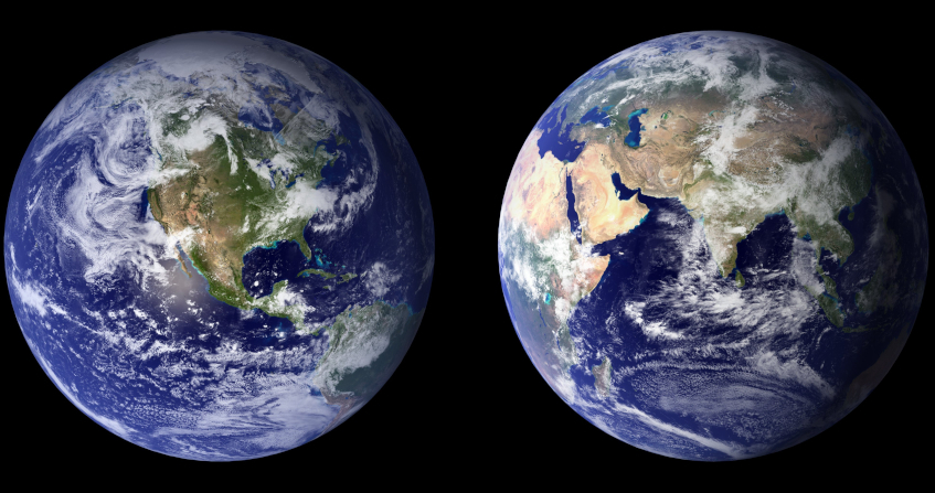
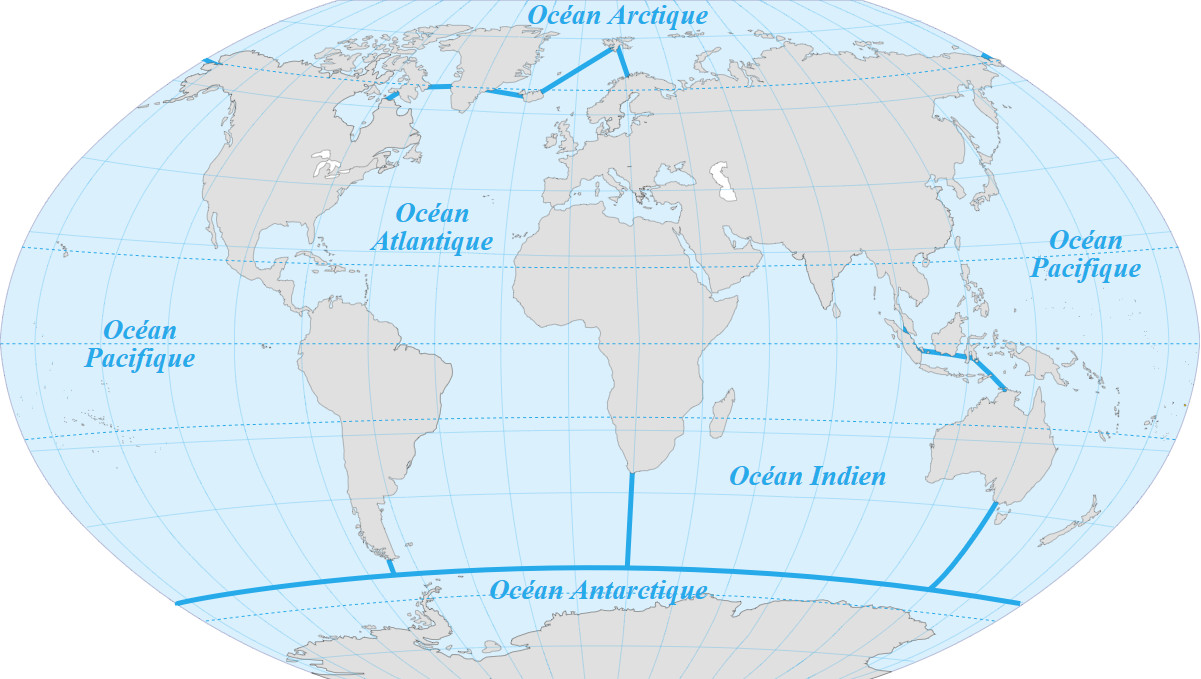
Figure 1. Official limits of the 5 oceans of the planet. [Source: Pinpin / CC BY-SA (https://creativecommons.org/licenses/by-sa/3.0)]Globally, the oceans represent about 72% of the surface of our planet. This immense domain where life appeared more than 3.5 billion years ago (Read The origin of life as seen by a geologist who loves astronomy) exerts a major influence on the entire terrestrial environment. During the last glacial-interglacial transition, which began about 20,000 years ago, its average altitude varied by at least 120 metres. Previously the English Channel and the North Sea did not exist and our Cro-Magnon ancestors could walk dry from the territories of the present European continent to those that became the British Isles. During the Holocene, a geological era spanning the last 10,000 years, the oceans have acquired boundaries that do not vary over the millennium, which led the International Hydrographic Organization[1] (IHO) to propose their division and to establish their names (see Figure 1). Nevertheless, they still carry great uncertainties, especially about the living organisms that inhabit them.
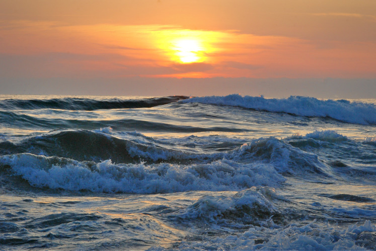
Figure 2. Usual appearance of the sea and ocean surface, agitated by swell and waves. [Source: Royalty-free image]The main aspect of the ocean surface before our eyes is its constant agitation, marked both by the swell and waves that can become threatening and by the tides that periodically invade the harbours (Read The tides). If, after filtering out all these oscillations, one observes the average shape of the ocean surface, it appears that it is neither flat nor round but bumpy. The difference in altitude between the highest regions, south-east of Greenland, and the lowest regions, south of India, reaches 160 m. In the particular case of the Mediterranean, this difference reaches 80 m, with a maximum altitude near the Balearic Islands and a minimum in the south-east of Crete (see The marine environment). Below this surface, even if it is not visible from land, water circulates and travels across the gigantic ensemble of the five oceans, with an often unsuspected but impressive slowness, inertia and power. This circulation has a noun, the thermohaline circulation, where the adjective reminds us that it is strongly dependent on density variations, which are due to temperature (thermo-) and salinity (-haline [2]), as we will see more precisely later on.
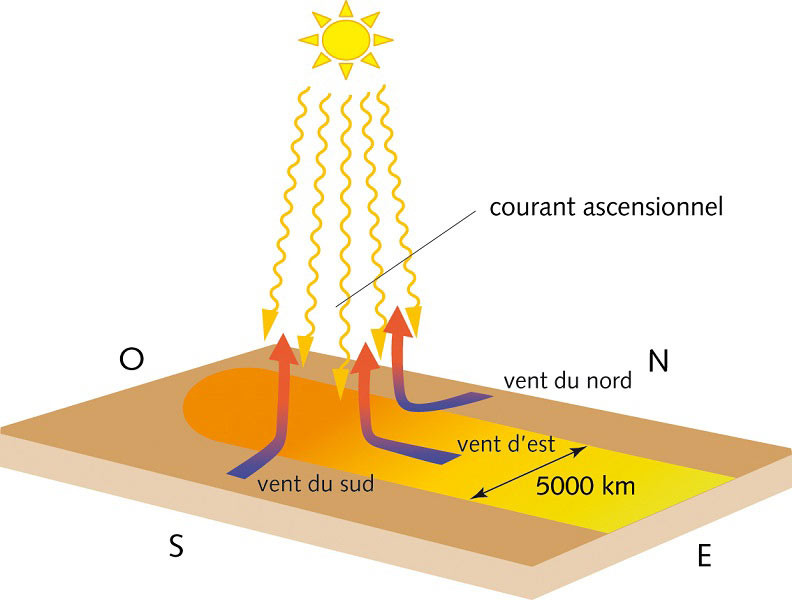
2. A single engine for air and water: sunshine
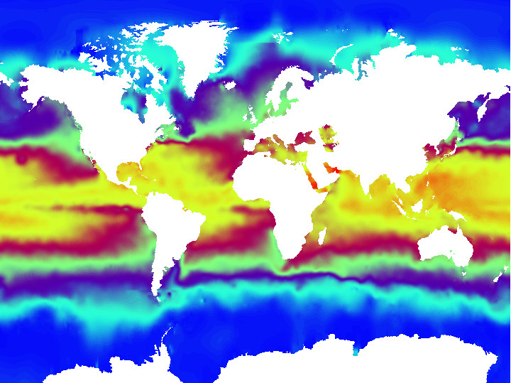
Figure 3. False colour visualization of ocean surface temperature in July 2010. The red colour marks the highest temperature, close to 22°C, the blue colour marks the lowest temperature, close to 0°C. [Source: MrFerraille / CC BY-SA (https://creativecommons.org/licenses/by-sa/3.0)]The direct heating of seawater by the Sun, more important than elsewhere in the tropics, responsible for the high temperatures of the waters above the thermocline (Figure 3), is the driving force of the atmospheric circulation (Read Atmospheric circulation: its organization). It is in return that the winds thus generated drag the surface waters by friction and set up the slow and powerful thermohaline circulation. It should therefore be noted that all the kinetic energy of these two fluid media, the atmosphere and the oceans, is provided by sunlight.
But there is an important difference between air and ocean water circulation: coasts and shallow waters are impassable obstacles, which ocean currents have to bypass. Nothing comparable diverts major air currents such as trade winds (Read The key role of trade winds) and jet streams (Read Jet streams). Furthermore, variations in density, which can cause heavy surface waters to plunge to great depths when they become colder or saltier, and can also cause them to rise to the surface when they are lighter, impose a completely three-dimensional structure on this marine movement.
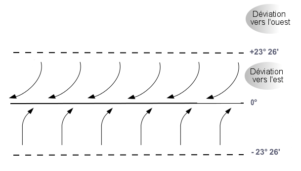
Outside the equinoxes, the situation is less symmetrical since the Earth’s trajectory causes the Sun to be seen further north in summer and further south in winter. At the height of summer, the trade winds no longer converge towards the equator but towards the Tropic of Cancer, situated at a latitude of +23°26′ in the Northern Hemisphere. Then the Coriolis force, which deflects them both to the right, makes their horizontal components relatively antagonistic (Figure 5).
Together, the weak but constant easterly wind and equatorial easterly current were able to carry Christopher Columbus’ schooners to Venezuela and the West Indies. They remain well known to sailors in Tall Ship Races across the globe, although their relative weakness leads these competitors to prefer to capture in their sails the strong thrust of a powerful storm.
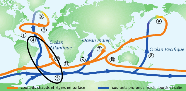
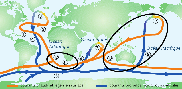
The overpressure thus formed along the North American coast of the Atlantic Ocean pushes the waters of the Gulf Stream towards Europe, at latitudes where the trade winds no longer exist and therefore cannot oppose them. As a result, waters that are still quite warm and light are approaching Spain, France and United Kingdom (number 2), while at the same time warming the accompanying layers of air, which on average also flow eastwards at much greater speeds. This dominant wind coming from the west, which can be quite strong and quite unstable, is induced by the polar jet stream which circulates at high altitude. These two currents, marine and air [5], favour the relatively mild temperatures we experience in winter in Western European countries compared to those in North America at the same latitude. A little further downstream, the coasts of northern Europe form a new, almost impassable obstacle [6] and divert the waters of the Gulf Stream, now westward, still with a northward component, so that the sea current flows towards Iceland and Greenland (number 3).
5. The Gulf Stream dive and its return to the south
Due to the shallowness of the Arctic Ocean, this marine current can only return southwards since its density requires it to reach the depths where it remains fairly well channelled in the abyssal trenches. Once it reaches the southern hemisphere where the Atlantic Ocean is widening, it cannot escape the Coriolis force, which forces it to divert eastwards, i.e. towards Africa. It is therefore the Earth’s rotation, modelled by the Coriolis force, that forces this current to turn around the African continent to the south, and not the American continent. The next obstacle on this trajectory, which is generally directed southwards, is the Antarctic continent, which forces this deep loop to circumnavigate it from west to east (number 5).
Another less well-known effect is due to the fact that along its elliptical path around the Sun, the Earth sweeps over a torus. The ellipse on the outside of this torus is longer than the ellipse on the inside, with a difference of about 80,000 km. This difference in distance travelled in one year adds a significant contribution to the thermohaline circulation, especially in tropical regions: by conserving the inertia of the global system, it implies a speed difference of 220 km/day, or about 9 km/h. This effect represents an additional motor of the equatorial current, which is added to the motor of the trade winds, as it acts in the opposite direction to the Earth’s rotation around its axis.
7. Some figures with an overview of secondary currents
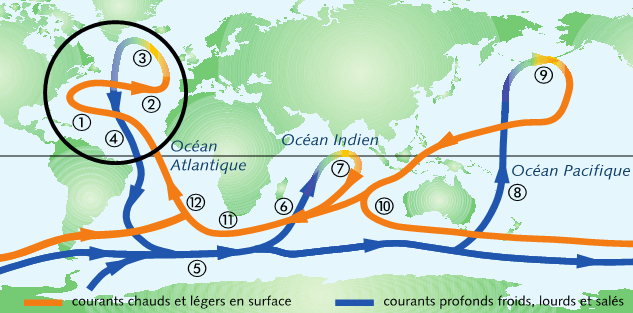
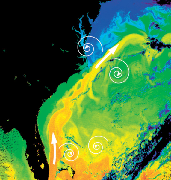
Figure 7. The Gulf Stream and its slowing eddies. False color photograph taken by NASA. Note the higher temperatures (orange colour) in southeast Florida (black peninsula in the Figure) and the formation of eddies in slightly colder waters (yellow and green colours), then much colder from the latitude of Cape Hatteras in North Carolina to that of New York (blue colour). [Source: Donna Thomas / MODIS Ocean Group NASA / CFSG SST produced by R. Evans et al, U. Miami]. American Public Domain]We have just followed, step by step, this immense thermohaline circulation, which must be considered as the main oceanic circulation because of its gigantic inertia, its climatic consequences, and its own influence on secondary ocean currents. A few figures are useful to situate this primordial importance. One of the most significant is undoubtedly the total duration of the circuit, of the order of 1600 years [8]. The highest speeds measured are of the order of 10 km/hr. However, this figure greatly overestimates the average speed, certainly less than 1 km/h due to numerous slowdowns linked to the formation of very large spiral eddies between the main current and the large fluid domains bordering it.
As an example, illustrated in Figure 7, the Gulf Stream, the main current in the North Atlantic between Florida and the European coasts, can be seen as a kindSeule 3 en exposant of river of very great width, at least 100 km, inserted in the ocean itself between immense slowing eddies. Let us assume that this relatively warm branch of the Gulf Stream remains above the thermocline, so that its depth can be estimated at about 50 m. We can immediately deduce from these figures an estimate of the flow transported by this North Atlantic loop: billions of m3/hr.
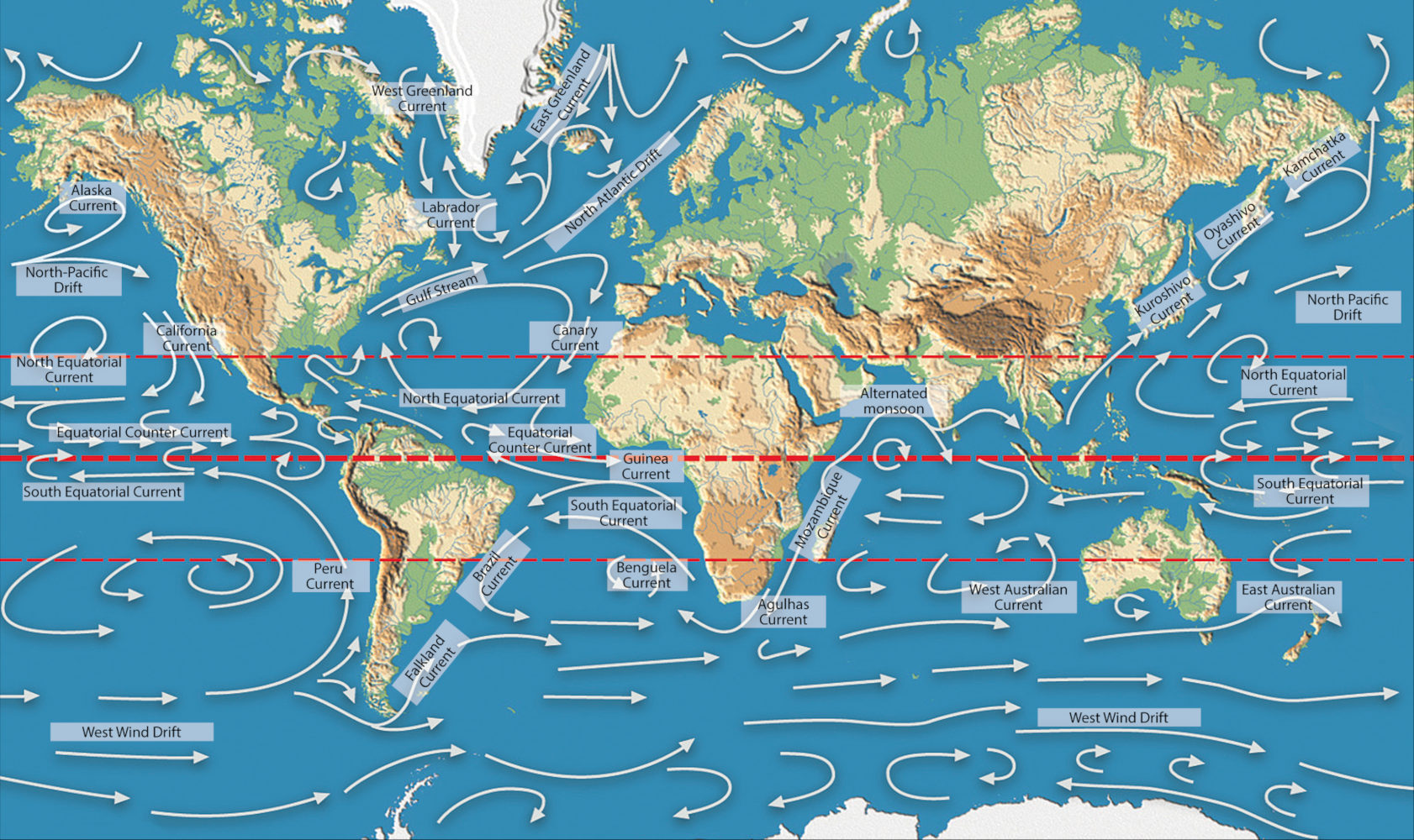
Without going into the description of this whole set of currents, a quick look at Figures 6 and 8 is enough to highlight the influence of the coasts, which obstruct the circuit, redirect it and generate the numerous secondary loops. It should be added that some portions of the oceans have an identity marked by the geometry of their coasts. This is notably the case of the Caribbean Sea almost enclosed between the Gulf of Mexico to the north and west and the great chain of Caribbean islands to the southeast.
8. This vast reservoir of nature that is the sea
Figure 9. Schematic representation of the 5 gyres in which plastic pollution accumulates. [Source: NOAA / Public domain]In support of these words by Jules Verne [9], it should be noted that the ocean cannot be reduced to the aqueous vastness described above. Water from rivers and precipitation arrives laden with all kinds of suspended materials and detritus. Freshwater escapes by evaporation, before falling back to land or sea in a variety of precipitation events, thus contributing to the water cycle. All these materials, whether mineral or organic, end up accumulating in the oceans, which have this extraordinary capacity to retain them. Some of these materials support the animal and plant species that inhabit them. The others, gathered at the bottom, constitute the sediments that may form the soils of continents of a later geological era.
Long-lived wastes such as plastics that are lighter than water are collected and concentrated by centripetal force [10] in gyres, which are now well catalogued (See Plastic pollution at sea: the seventh continent). There are usually five of these, highlighted in Figure 9, in which thousands of tonnes of plastics are currently stored, forming what is often referred to as the sixth oontinent.
In the calmest conditions, the sea is never stationary, since it is traversed by powerful ocean currents, especially in the deepest portions of the loops of the great thermohaline circulation. We have seen that this major circuit determines all the others. Its slowness justifies the fact that the marine environment is often described in quasi-static terms. Nevertheless, however slow this thermohaline circulation may be, the flows transported are such that the impact of its movement on atmospheric circulation, meteorology and climate is considerable.
Figure 10. A sample of life in the oceans: fish and corals. [Source: Royalty-free image]The sea was also the cradle of life more than 3.5 billion years ago. For almost 3 billion years it remained the only environment where life could develop and diversify, before certain species managed to profoundly modify the earth’s atmosphere by oxygenating it, then moved to the land masses and found there the conditions for new development (Read Lamarck and Darwin: two divergent visions of the living world). This implies in particular that most of our planet’s biodiversity is found in the marine environment (Figure 10), where the number of living species is estimated at between 5 and 10 million, many of which are still unknown. By way of comparison, the number of species living on land is in the order of 1.3 million, including 850 000 species of insects.
9. Messages to remember
The thermohaline circulation travels across the oceans with an astonishing slowness since the duration of a complete circuit is of the order of 1600 years. Nevertheless the masses transported are considerable and give this circulation a gigantic inertia.
The birth of this circulation comes from the converging influence of the trade winds that generate the slow equatorial easterly current in the Atlantic Ocean. As it is unable to cross the American continent, it gives rise to the Gulf Stream in the North Atlantic Ocean.
In the vicinity of Greenland, the Gulf Stream has become heavier and plunges into the great depths to return to the southern hemisphere, bypassing Africa and the Antarctic continent.
Two loops separate from it and return northwards into the Indian and Pacific Oceans, where, lightened, they can rise to the surface, return to the Atlantic Ocean and thus close this immense circuit.
In every ocean, the surface current is slowed down by slowing eddies, some of which lead to the formation of gyres where the centripetal force concentrates large quantities of light waste such as plastic objects.
This thermohaline circulation and secondary currents have a considerable influence on meteorology and climate, of which they are the most stabilising element.
Notes and References
Cover image. The vastness of the oceans around the land [Source: Royalty Free Image]
[2] The suffix haline is derived from the Greek words alos (άλος, sel) et alinos (αλίνος, salin).
[3] Comes from the Latin word aequinoctium, formed from aequis (equal) and nox (night) and locates the date when the duration of day and night are equal.
[4] Introduced by Gaspard Gustave Coriolis (1792-1843), this force makes it possible to model movements in the referential of earth observers, although it is not a Galilean referential. Because the Earth rotates around its axis in the direct direction, Earth observers see the trajectories of all objects that are not fixed on it deflected in the opposite direction. This deviation is zero at the equator, maximum at the poles, to the right in the northern hemisphere, to the left in the southern hemisphere. More details can be found in our article The Atmospheric Circulation.
[5] It appears that the Gulf Stream’s share of winter temperature differences, in the order of 10 to 15°C at a given latitude, between the coasts of western Europe and eastern Canada is much greater than the share of the jet stream-induced western airflow.
[6] The Strait of Gibraltar is far too narrow to absorb a significant fraction of this current. On the other hand, the English Channel, on its scale, allows a significant flow to penetrate which generates the strong tides of the Normandy coasts. However, on the scale of the Atlantic Ocean, the flow thus taken remains moderate.
[7] Generally speaking, when solidifying a liquid mixture where two phases, a solvent and a solute, can always be distinguished, these two phases do not have the same solubility in the solid state as in the liquid state. This leads to an enrichment of the liquid phase with solute, in this case an enrichment of seawater in the vicinity of the pack ice with salt.
[8] By way of comparison, air currents such as jet streams, which travel at speeds of up to 300 km/h in the case of the polar jet stream, take only a few days to circle the entire planet (Article The jet streams)
[9] This vast reservoir of nature that is the sea is an expression taken from “Twenty Thousand Leagues Under the Sea”, one of Jules Verne’s best-known works. First published in serial form between 1869 and 1870, this novel is the fifth most translated book in the world. It has been widely adapted for film and television.
[10] In a rotating fluid mass, the centrifugal force deflects the heavier components outwards; conversely, the centripetal force deflects the lighter components inwards.
The Encyclopedia of the Environment by the Association des Encyclopédies de l'Environnement et de l'Énergie (www.a3e.fr), contractually linked to the University of Grenoble Alpes and Grenoble INP, and sponsored by the French Academy of Sciences.
The articles in the Encyclopedia of the Environment are made available under the terms of the Creative Commons BY-NC-SA license, which authorizes reproduction subject to: citing the source, not making commercial use of them, sharing identical initial conditions, reproducing at each reuse or distribution the mention of this Creative Commons BY-NC-SA license.
The only driver of atmospheric circulation is sunlight. Under the constraints of gravity, Archimedes’ thrust…
René MOREAU, Professor emeritus at Grenoble-INP, Laboratoire SIMaP (Science et Ingénierie des Matériaux et des Procédés), member of the Académie des sciences and the Académie des technologies
More than two thirds of the Earth’s surface is occupied by seas and oceans. Heated…
René MOREAU, Professor emeritus at Grenoble-INP, Laboratoire SIMaP (Science et Ingénierie des Matériaux et des Procédés), member of the Académie des sciences and the Académie des technologies