


预报员的作用
预报员通常是指负责进行天气预报的气象学家。本文介绍了2016年预报员的岗位职责及其使用的工具和方法。全球所有公共或私营气象服务机构内均设有预报员岗位。本文介绍了预报员的主要职责:保障公众的人身及财产安全。此外,预报员也服务于众多对天气或气候敏感的职能部门,根据观测和预报的天气情况提供决策支持。
1. 预报员,一个不断发展的职业
预报员的首要职责是向用户或客户解释并描述所关注地区的未来天气状况,以适当的沟通方式传递高质量的技术信息。这是一个古老的使命,目前,这一职业不仅存在于所有公共的国家气象服务部门(NMSs),也存在于从事气象工作的私营部门实体中。气象部门的人员状况和费用问题是国际比较研究的主题。近些年,数值天气预报(NWP)取得了长足进展(参见天气预报介绍)大气监测手段发生了显著变化,这使得预报员的职能也随之发生了变化。
系统地使用数值天气预报模型进行预报可以追溯到20世纪70年代和80年代。从这一时期起,数值预报开始提供有关中纬度地区可能发生风暴的相关信息。风暴会对人员和财产造成巨大损失,对其进行预测至今仍是欧洲关注的焦点。强大风暴的发生促使法国于1856年在巴黎天文台内设立了国际气象服务[1],并于2001年实施了气象警戒系统[2]。
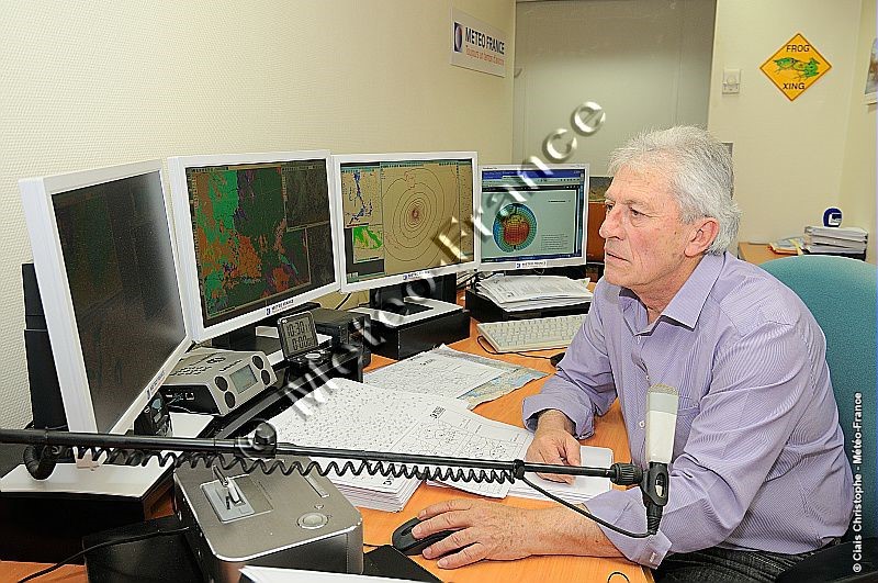
[图片来源:©法国气象局]
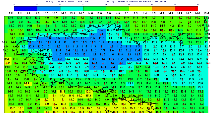
目前预报员的工作主要包括对现有数值模拟进行解释,并对预报数据构建手段的进展情况进行监测,如提高数值天气预报模型及后期处理(统计调整)的质量。得益于在信息使用方面以及规划领域的可视化方面取得的长足进展,上述工作已成为可能。事实上,这些数据已经从纸上的图形输出转变为计算机表示[3]。此外,排版和传播这些预报结果的可能性也大幅提升(印刷媒体、视听、电话亭、互联网、移动电话)。如今,公司的绩效要求以及在短时间内需考虑的信息量使得预报员的工作既充满挑战又令人兴奋(图1)。
2. 方法论的一些要素
预报技术取决于所预报的“气象对象”的时空尺度:如比利牛斯山顶下午的一场风暴,塞文山脉次日的一场暴雨,以及法国下周的一场热浪。所有这些都基于预报方法,其中包括分析和预报两个阶段。
[图片来源:©法国气象局]
预报步骤首先包括了解在分析过程中识别的结构将如何随着数值模拟而演变,或者,若无法演变,则寻找最能代表它们的可用外推产品。在短期内,由于这种演变在某种程度上具有线性属性,预报员很容易纠正上一步骤中出现的缺陷:例如降水或雾区的地理转移,低估了低压加深的强度。这种预报称为确定性预报。从长期来看,由于大气的演化是非线性的,一些结构可能会消失,而另一些结构可能会产生。数值建模(参见天气预报模式)的优势在于能够模拟这些外推法所无法模拟的事件。外推法的分析无法区分数值模拟中可能存在的不同选项。
在第二步中,该方法变得具有概率的性质。在一系列可能的发展中,预报员寻找最有可能出现的情况,评估预报中涉及的问题,并设法使潜在的预报误差最小化。这种评估基于集合预报(Atger,2000)[4]的使用(参见集成预报),但也可通过比较国家气象部门提供的不同确定性模型的模拟来进行。这里需要注意的是,短期和长期的概念与我们试图预报的气象现象有关。我们谈论的是可预测范围:对于一场暴风雨而言是几个小时,对于暴风而言则是几天。还应补充的是,通过预报员在分析、预报和验证预报的常规活动中所获得的模型行为知识,可以识别这些数值天气预报模型中某些反复出现的缺陷。这些要素涉及预报过程,但也用于改进数值预报本身(减少已识别的偏差)。矛盾的是,这种反馈使得预报员越来越难以对模型进行批判性地检验!最后,强调要联合使用全球模式(覆盖全球)和有限区域模式(覆盖有限地理区域)来解决不同尺度的大气现象问题。另一个困难是,区域模拟不一定会放大用于耦合的预报,但由于具有一定的自主性,这种小尺度预报可能与大尺度预报有很大差异。
3. 保障人员和财产安全——一项重要任务
向当局、公民、交通、能源和通信基础设施管理利益攸关方预警可能发生的气象危险是国家气象部门的主要任务之一,也是其存在的原因之一。自2001年以来,法国气象局通过气象监测系统(Beysson,2001)[2]履行这一职能。许多国家,尤其是欧洲国家,都不同程度采用了这一程序,法国国家和地区预报员负责执行这一程序。由于需要连续性,该工作安排被设置成提供24小时天气监测的常设服务。
这种监测或跟进作用有时被低估,但却至关重要。它包括检测任何未预料到的潜在危险气象现象,以便尽快向那些可能受其影响的用户发出警告。这项任务很困难,一方面是因为此类现象是出乎意料的,另一方面是因为目前的观测手段可能不足以监测到这类现象。例如,冬季某些路段的冰雪状况是无法感知的。在这一领域,新兴的车联网技术为气象观测提供了有趣的应用可能性。警戒监视图发挥了预测危险现象的作用。该图用绿色、黄色、橙色和红色四种颜色显示各省在未来24小时内气象和水文危险的警戒水平。颜色的选择基于所考虑的参数超过阈值的标准(2016年有9种危险)。
[图片来源:©法国气象局]
需要补充的是,在专业部门中也存在监测和预测的角色。海事领域针对海况采用了特别预警系统。在航空领域,对悬浮在大气中的火山灰、结冰以及威胁到飞机安全的湍流现象也实施了其他预警程序。后者由具有国际民航组织认可资质的气象预报员执行。在发生核事故、化学事故或海洋污染时,预报员会对所谓的环境紧急情况进行干预。按需使用特定数值模型,即所谓的扩散模型,以提供可能受污染物影响的地理区域的信息。
4. 气象援助,不同活动领域的决策支持实例
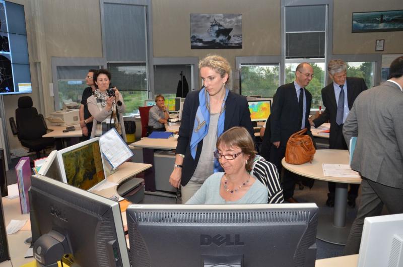
有些活动部门的成就依赖于天气条件,这些部门利用气象实体的服务来满足自己的需要。这个功能称为气象援助或建议(图4)。有些机构选择将这一职能纳入其组织内部。例如,法国电力公司(EDF)的预报员团队参与了水电生产的水资源管理。其他具有更具体需求的组织机构将这一功能外包出去。体育赛事的组织者要求天气状况众人皆知,这些任务由经过专门培训的预报员负责执行。他们有时会前往活动地点,尽可能接近用户,从而提供量身定制的服务。预报员使用专用的观测手段,例如移动气象雷达,从而大大提高对活动现场降水发生的预测能力。
[图片来源:©法国气象局]
5. 未来展望
数值天气预报(NWP)的巨大进步、模型空间分辨率(千米级)的急剧提高、数据可用性的时间步长,预报更新的频率(越来越接近于同化周期),正在改变和扰乱人类专家在预报过程中的作用。目前所能获取的信息量之大,有时无法在给定的时间内对这一进程进行评估。因此,越来越多的预报是自动化的,即通过计算机处理链直接提供给用户,而无需人工干预。此外,在公共和私营部门中许多实体都在实施降低成本的政策,这往往会限制人类专家在这些组织机构中的地位。而这些机构因此会寻求更高程度的自动化。预报员应在何时、哪些领域发挥自己的专长?我们是否应该只关注具有高社会或经济风险的情况?专业知识是否应该投入于目前在月度和季节范围内出现的新的预测应用领域?这些都是21世纪气象服务部门面临的问题。
参考资料及说明
[1] Roy, S., 2012: 125 years in the shadow of the Eiffel Tower, Météo France
[2] Beysson, J.P., 2001: Editorial, review La Météorologie 8ème série n°32, p. 3, by the association Météo et Climat
[3] 计算机显示有多种形式:地图、时空部分、动画。通过研究定点观测、无线电探空仪、雷达或卫星图像以及社交网络上的共享信息,可以了解当前(当前时间)的气象条件。
[4] Atger, F., 2000 : La prévision du temps à moyenne échéance en France, revue La Météorologie 8ème série n°32, p. 61, by the association Météo et Climat
[5] Georgiev, C., P. Santurette, K. Maynard, 2016 : Weather Analysis and Forecasting, 2nd Edition, Academic Press
[6] Beucher, F., 2010: Tropical meteorology: from trade winds to cyclones, 2 volumes, Météo France
[7] Santurette, P., A. Joly, 2002: ANASYG/PRESYG, Météo-France’s new graphical summary of the synoptic situation, Meteorol. Appl. 9, p. 129-154
[8] Giezendanner, Y., F. Guais, 2007 : Le routeur des cimes, Editions Paulsen
环境百科全书由环境和能源百科全书协会出版 (www.a3e.fr),该协会与格勒诺布尔阿尔卑斯大学和格勒诺布尔INP有合同关系,并由法国科学院赞助。
引用这篇文章: GILLET-CHAULET Bruno (2024年3月11日), 预报员的作用, 环境百科全书,咨询于 2026年7月25日 [在线ISSN 2555-0950]网址: https://www.encyclopedie-environnement.org/zh/air-zh/role-of-forecaster/.
环境百科全书中的文章是根据知识共享BY-NC-SA许可条款提供的,该许可授权复制的条件是:引用来源,不作商业使用,共享相同的初始条件,并且在每次重复使用或分发时复制知识共享BY-NC-SA许可声明。