


多功能河流开发:以罗纳河为例
1933年,为了满足发电、航运和灌溉等特定需求,罗纳河国家公司成立。此后,又陆续出现了一些尤其与休闲娱乐相关的新需求。
这三十年来,罗纳河已经实现了生态修复,这要归功于在项目设计和运行过程中,恰当地考虑了环境因素,包括增加最低保留流量,恢复旧弯道和冲积边缘,以及重建鱼类迁徙路线。在追求发展的同时,还须兼顾两点:一是如何为后代子孙保护罗纳河沿岸的生物多样性,二是如何发挥该河流域的社会效用。
1. 为什么要开发河流?
纵观历史,大河及其周边环境兼备生活、贸易、农业和捕鱼等功能,一直是人类聚集区。
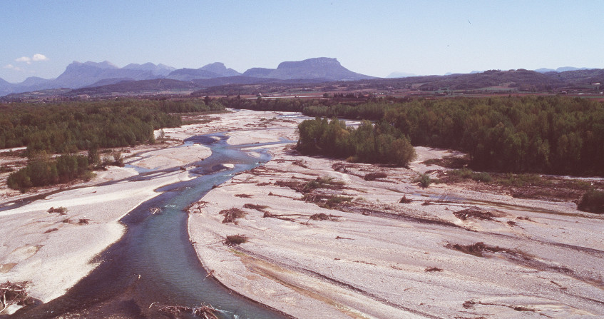
但是,河流也伴随着风险。常见的风险有大洪水、河岸和河床的侵蚀、严重干旱以及阻断交流。即便如此,为了河流带来的财富,人类愿意承担这些风险。河流的价值不胜枚举:饮用水、渔产、高质量农业平原、航运,以及后来才实现的水能利用、工业用水、废水处理、建筑材料和水上运动。单独考虑的话,上述每项价值的开发都有可能导致用水冲突。除此之外,整条河流的动态平衡牵一发而动全身,河谷中任何时刻任何一个显著变化都会对其造成干扰,并在空间和时间上产生深远的影响(请参阅:与河流共存:一个地貌学问题)。对一个河谷来说,上游和下游、河床和河漫滩、以及地表径流和地下水位,彼此间都息息相关。
按照多功能低水头水电方案开发河流,既能实现河流自然资源的最优化利用,又能均衡满足各方面需求。在低水头河流上,如果大坝开发设计得当,既不会改变水质,也不会影响泥沙输送,同时还能助力航运的发展并滋养肥沃的农业平原。要做到这些,河流的功能必须得到优化,以实现各自的目标,在满足发展发电、航运和农业等目标的同时,确保不会导致洪灾的易发。
然而,近年来,河流开发又有了新的目标——发展旅游业、修复物质遗产和提高环保意识,于是河流开发的重点和优先级也随之改变。大型河流的多功能开发须具备足够的容量以适应开发目标的变化,包括尊重环境,甚至在气候变化的背景下恢复环境。
本文以罗纳河的多功能开发为例,介绍了过去几十年里多功能开发的原则和演变过程,强调了开发的一个关键——为了保证流域利益,开发时须对经济、社会、环境和可持续发展等多方面目标综合考虑。
2. 罗纳河的开发
为了促进航运发展,罗纳河的管理始于19世纪。从工业时代开始,随着其它用水需求的出现,罗纳河的管理方法也随之改进,以满足这些需求。
法国政府于1921年5月27日通过了相关法律,决定开发罗纳河,并将其法国部分[1]的管理交给成立于1933年的罗纳河国家公司(以下简称为CNR)。罗纳河在日内瓦湖上游的部分,属于(瑞士)联邦环境办公室。而罗纳河在日内瓦湖下游的瑞士部分,则是日内瓦州的财产,由日内瓦工业公共机构(以下简称为GIS)管理。泥沙治理则由GIS和CNR共同完成。除此之外,CNR还有三个主要目标:
- 水力发电;
- 提供宽尺寸航道;
- 促进农业发展。
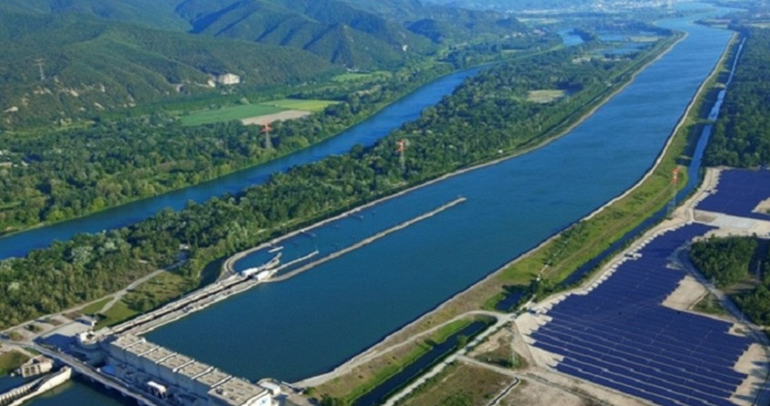
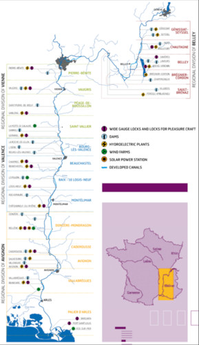
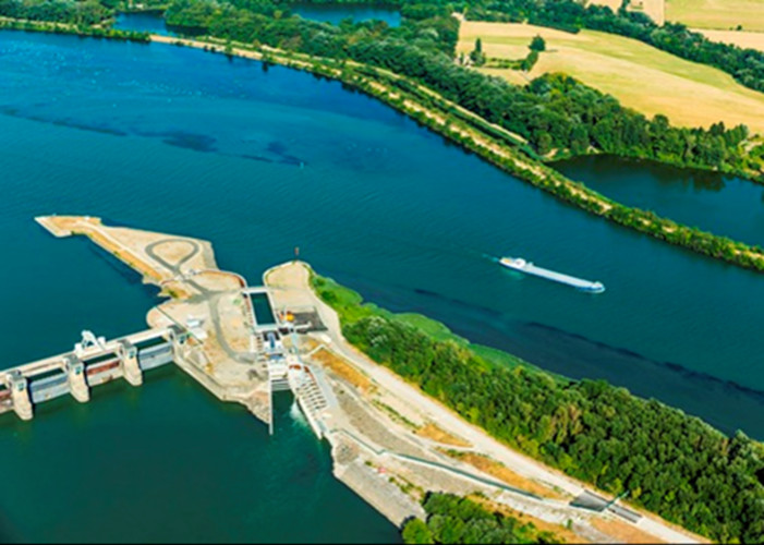
1948年至1986年间,CNR建立了19个梯级多用途发电厂[2](3000兆瓦装机容量),分布在瑞士和地中海之间长达520公里的罗纳河道上 (图1)。
目前,罗纳河是欧盟登记在册的一条航道。根据欧盟交通部长会议(ECMT)上的分类,该河属于Vb类,即允许长度172到185米,宽度11.4米,吃水2.5到4.5米,吨位3200 到6000 吨的船只在里昂和地中海之间通航。另一方面,罗纳河可对12万公顷的土地进行灌溉。农作物的水分需求由北到南逐渐增加,依次为玉米、油菜籽、早期作物、果园、水稻(在2014年灌溉用水占罗纳河净取水量的50%[3])。
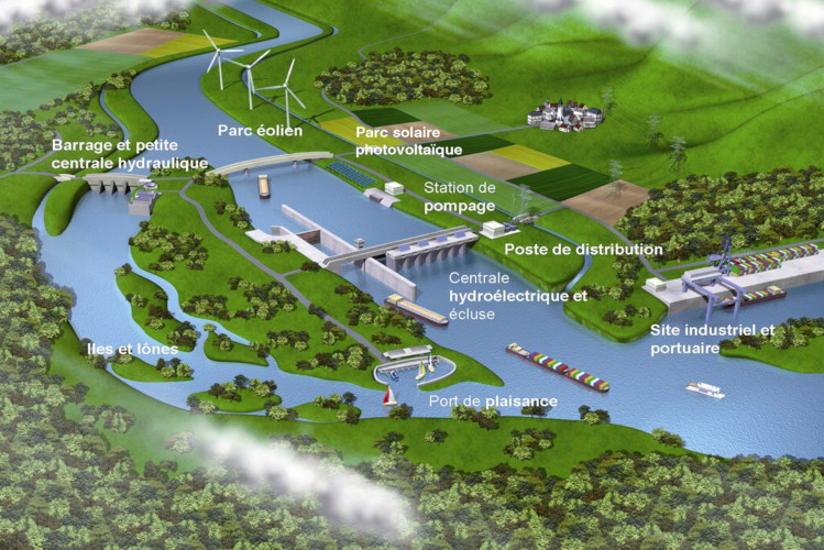
Barrage et petite centrale hydraulique 大坝和小水电站;Parc éolien 风电场;Parc solaire photovoltaïque 光伏太阳能园区;Station de pompage 加油站;Poste de distribution 配送站;Centrale hydroélectrique et écluse 水力发电站和船闸;lies et lones 孤岛;Port de plaisance 码头;Site industriel et portuaire 工业和港口站点
2001年,法国电力市场开放,CNR随之成为一个独立的发电企业。罗纳河法国段的发电设计采用的是一系列低水头水力发电方案,如图1、图2所示。其中格尼西亚特大坝是个例外[4],它是一个中水头大坝,其对应的水库允许以周为周期进行管理。除格尼西亚特大坝外,其余每个水库的发电设计方案,都包含了以下几个设施:
- 大坝:配有可移动闸门,提升罗纳河的水位;配有鱼类迁移设施和一个小型水力发电装置,发电不影响河流生态;
- 引水渠:通常位于冲积平原,与水电站大坝创造的水力落差、水电站的通航闸道和灌溉取水口配套。
这些工程根据场地的需要因地制宜,不断完善。具体有:
- 在堤坝边缘修筑反向排水沟,保护河岸平原免受蓄水的影响。保留开发前存在的河漫滩区,以保证防洪能力,防止下游洪水加速。通过潜水堤和溢洪道向这些洪水扩张区泄洪。
- 修建工业区、港口区以及小型码头等。
- 生产其他可再生能源(光伏发电厂、风力涡轮机等)。
3. 不断改变中的目标和优先级
在大型河流的开发过程中,涉及到多方利益,不同的利益相关者往往会提出不同的用水需求,这很大程度上影响了开发目标的优先级和开发前景。
以罗纳河为例,虽然两千年来一直像“母亲河”一样,哺育了众多主要城市和大片农业区,但直到20世纪初她仍然是一条携带着大量未开发资源和洪灾的狂野之河。
因此,罗纳河周边居民——1921年“罗纳河法”的倡议者们,他们当时的主要考量和诉求,是稳固河岸、保障农业供水和改善航行条件——既不能使流速太快,也不能在枯水期无法通航。
要想实现这些目标,需要建设大型工程和基础设施。这些大型工程和基础设施的资金来源,正是水电开发(CNR的三大目标之一)。
这种以水力发电为手段,航运和农业为目标的模式,在很大程度上主导了实现罗纳河开发的条件,构成了罗纳河河谷可持续发展的基因。
与罗纳河关联的地表及地下水资源的质量是否良好,是一个所有河流用途都必须考虑的焦点。要改善罗纳河的水资源质量,需要依靠实施欧盟相关法规,来解决来自工业和农业的历史遗留污染。
3.1. 发电

水能是世界第三大电力来源,仅次于煤炭和天然气。因为其具有低碳[5]和低生产成本的优点,水电是目前为止对缓解气候变化贡献最大的可再生能源。事实上,在二氧化碳平衡方面,水电是目前所有已知的电力来源中表现最佳的:水电的二氧化碳排放量比燃煤电厂的低250倍,比风力涡轮机发电低3倍,比核能发电低4倍,比光伏太阳能发电低20倍。
这是一项有助于河流多功能管理的长期投资。
与其他传统电力来源相比,水力发电属于资本密集型行业(建设基础设施和购置重型设备:图3),在项目开始时具有高风险(体现在水文、地质、社会和环境接受度方面)。能源资产往往需要具备短期盈利能力,所以水电在金融方面也可能面临新的挑战。
尽管水电存在这一劣势,但多年来,CNR的多功能开发计划仍然得以成功实施,这得益于公司寻求的水电收入与非盈利的内陆航运和灌溉用水之间达到的财务收支平衡。
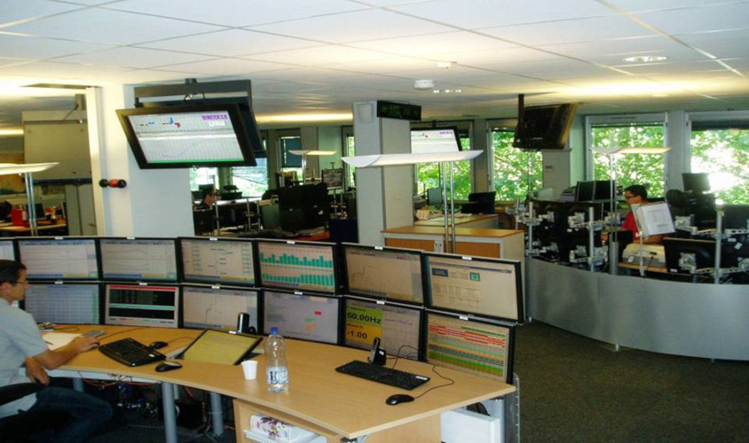
自本世纪初,法国开始实施电力市场开放,CNR随之成为一个独立的电力企业,并建立了一个创新且综合的机构来管理其间歇性能源的生产。为面对价格波动与产销不平衡带来的风险,CNR也在不断改进其预测、规划、营销和资产远程控制方面的技能(图4)。
此外,CNR还丰富了电力来源类型,但无一例外都是太阳能和风能等可再生能源。同时为了实现能源转型和减少温室气体排放,还致力于技术创新——潮汐能、电力的储蓄和调动、储氢等。
这种模式已被采用了80余年,至今仍在不断发展中。通过集体和私人利益、经济效益和公共利益的融合,CNR提出了一种新的能源关系。自成立以来,CNR一直是绿色电力生产商和流域开发商,并积极致力于法国和欧洲的能源转型。
3.2. 航运
曾经有很长一段时间,法国对航运这种运输方式并不感兴趣,直到法国当局对多种用水征收原始税,利用税收为开发宽尺寸航道提供了大规模且持续的财政投资,才实现了对大型水道的设备和基础设施的再投资。彼时即20世纪末,法国河道的发展已落后于德国。
航运被认为是一种真正可持续的运输方式,在过去的十年中,法国政府鼓励发展河流航运,也包括罗纳河,旨在将非公路非航空货物运输从2009年的14%增加到2022年的25%(格雷内尔,2009年8月3日出台的规划法)。
可持续内河航运满足可持续发展三个原则的要求:
- 环境友好性:与公路运输或空运相比,内河航运的耗能少,且温室气体排放量低。平均而言,在罗纳河上使用一支可运载4400吨、264TEU(英语TEU或法语EVP是一个集装箱计量单位,1TEU相当于长度为20英尺的集装箱)货物的拖船船队,相当于在道路上使用220辆载重20吨的卡车。
- 经济竞争力:对于某些供应链来说,内河航运比公路运输成本低四倍。内河航运涉及多个部门,并且能很好地融入国际物流网络(以吨或千米为单位来衡量法国国家物流网络总量,其中一半以欧洲为源地或目的地)。
- 社会接受良好:航运的社会影响是正面的,因为它缓解了公路交通网络的拥堵,而且事故记录较少。另外,航运具有很强的发展潜力,特别是在罗纳河谷,它提供了多种直接、间接或诱生的就业机会。
除上述三大优势以外,内河航运还具有其它优势,值得关注的方面包括:促进文化和旅游遗产、交通网络的现代化所带来的流域发展、新港口基础设施的发展、连接铁路和公路基础设施的多模式平台,以及海港和中转站之间集装箱内货物的中转。
CNR已经建成了一个由18个工业和港口区组成的交通网络,以完成其作为罗纳河特许经营者的任务。
CNR所建设的交通网络的桥头堡是里昂爱德华·赫里奥特港(PLEH),无论是在运输量还是在规模方面,它都是罗纳-索恩盆地最大的港口。因此这个建设在罗纳河河谷中的交通网络是连接地中海和里昂北部宽广的索恩河的主要走廊,走廊途径马赛-福斯/塞特的诸多港口。
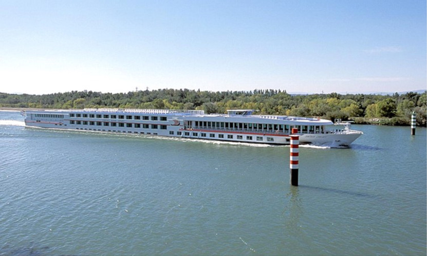
近年来游轮数量迅速增加,2018年在罗纳河上运送了20万名乘客。
3.3. 农业、灌溉和防洪

防洪一直是河流周边居民及其代表——民选官员、农业联合体、工业和城市等的主要顾虑。纵观历史,居住在河边的居民们已经抵御了最频繁的洪水袭击,而面对越来越极端的洪水,他们也绝不会轻易放弃他们的土地。
在世界许多冲积平原上,农业发展不仅是经济需要,还是一个国家主权问题。
CNR为了促进灌溉,建设有32个泵站,罗纳河谷得益于此,12万多公顷土地的农业生产用水得到保障。
政府对农业政策的财政支持,被用在稳定地下水位、土壤固结,以及农产品市场重组等方面。得益于此,罗纳河谷的灌溉得以发展,确保了河谷高效发展。灌溉用水来自CNR泵站。同时加大化肥和杀虫剂等农业投入,作物产量得到了提高。
人们已经认识到,流域发展有时是以牺牲毗邻河流的自然湿地为代价的。为拯救罗纳河的一些老支流和邻近的一些特别值得关注的自然区域,自然保护协会曾全力以赴。
与此同时,河漫滩的价值和优点又再一次走进人们的视野。河漫滩不仅能保持土地质量,还能补给地下水和提高湿地生态质量。除了灌溉任务外,CNR还致力于提供专业知识和技能,支持研究和实验,力图改良农业技术以减少作物对水和农药化肥的消耗,并且保护生物多样性。
3.4. 其他工业用途
在罗纳河谷,工业在当地经济中的比重仍然大于法国平均水平。工业活动类型丰富,主要位于里昂下游,集中了核工业、化工、石化和制药公司。工业活动用水量占罗纳盆地每年净用水量的36%(参考文献5)。罗纳河对工业活动的主要约束,体现在罗纳河沿岸的核电站的冷却(占年净用水的21%)上,冷却需要河水满足一定的流量和温度要求,最近几年就出现了核电站的供水困难期,在热浪和枯水期尤为严重(特别是在2003年和2006年)。
3.5. 水上休闲和河流旅游
河流开发伊始,发展目标集中在河谷的能源、工业和农业三方面的均衡,并未考虑到水上休闲和河流旅游。渐渐地,河流水位得到了很好的控制,人们渴望与河流进行更为亲密的接触,于是休闲文化逐渐发展。休闲文化的发展产生了一些互补的经济分支,这些分支也加入了河流发展目标行列。
如今,在地方当局与开发项目产权人的协商下,从项目开发之初便考虑关于休闲文化的用水需求。这样一来,可利用项目开发现场的机械设备及材料,减少了建设休闲设施的成本。
罗纳河沿岸,连绵分布着数个拥有200到300个泊位的码头,有众多水上运动设施,还有港口、沙滩、游泳池、冲浪体育场、垂钓区、度假村、餐馆和商店等一系列河流开发项目。
罗纳河道的开发促进了集体和个人河流旅游业的发展。几年前,罗纳河上游引入了新的休闲船闸,使更多游船得以在罗纳河中泛游。这些设施都是CNR制定的公益任务(MIGs)方案中的一部分。
3.6. 适应气候变化
针对气候变化的相关研究[6]预测,在21世纪末罗纳河流量季节间波动将会发生变化。在冬季,由于融雪时间的变化,流量将有所增加,而在夏季,由于冰川逐渐消失,流量将急剧下降,下降程度取决于不同的气候情景,约在50到75%之间。这一变化可能会在夏季造成用水冲突,尤其是在法国南部的灌溉农业和罗纳河沿岸运营的核电站的冷却方面。
4. 公益任务(MIGs)和适应环境
[来源:©Camille Moirenc]
2003年,CNR成为独立的电力生产商后,修订了其经营罗纳河的特许协议,在之前的开发任务的基础上,增加了免费的公益任务(MIGs),这是CNR自愿对罗纳河谷许下的承诺。CNR将公益任务分为若干个5年计划。CNR通过这种方式,向公众展现了其商业模式的独特性——流域财富共享原则,及长期发展观。CNR于2014年启动其公益任务的第三个五年计划。投入1.6亿欧元,该计划不仅紧跟国家能源、环境和河流运输政策动态,也关注促进可持续性农业、鼓励就业、发展旅游业,以及恢复遗产、教育和生活环境质量的时时变动的地方政策。
4.1. 生态流量
在研究生态流量方面,老罗纳河(未经开发区域)生态流量的增加非常具有指导意义。随着社会对环境保护的重视,河道内生态流量的价值也逐渐显现。
生态流量不是一个定值,与多个因素有关。一为开发程度;一为物理条件,即河道长度,或是否有支流供给等;一为季节,生态流量在冬季较低,夏季较高,有时其它季节也值得关注。
过去,在巴斯-罗纳河流域,河道内生态流量相较于河水平均流量来说相对较低,1000到1700立方米/秒的河水流量对应的生态流量只有几十立方米/秒。1984年“渔业”法出版,确定了河流保留流量的最小值,但由于罗纳河和莱茵河在国际上的重要地位,“渔业”法对她们并不适用,所以河道内生态流量较少的情况依然存在。
关于罗纳河生态流量的计划几经发展。1996年水开发和管理总体规划(SDAGE)启动,其后在1998年州政府启动罗纳河10年水力和生态恢复计划,接着在2003年对CNR特许经营协议的修改,确定了在罗纳河的几个河段中,可付诸实施增加其保留流量,使其恢复为一条 “活的和流动的”的河流。
正因如此,加上罗纳河流域居民需求的推动,水坝上得以增设小型水电站(SHP)以及鱼类过坝设施,实现了罗纳河生态流量逐步增加。
在罗纳河的几个河段中,都加入了对生态收益的考量,以降低富营养化的风险[7]。流量增多后水稀释作用增强,使得水更新时间得以缩短,再加上水位的提高和目标物种繁殖状况的改善,罗纳河流域水生生物栖息地的多样性增加才得以实现。
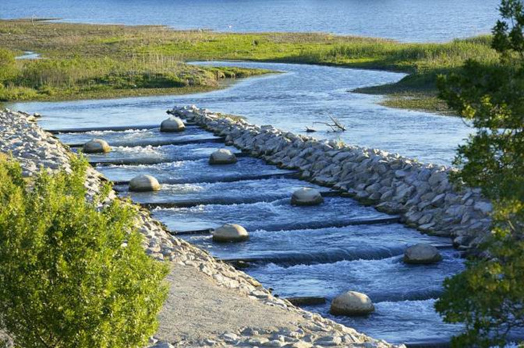
4.2. 洄游鱼类迁徙路线的恢复
1992年,罗纳盆地的“移徙计划”启动第一阶段,计划将西鲱的分布区扩展到罗纳河右岸主要支流之上的一块产卵地上,即恢复到1952年时的状况。计划所采用的是一种原始的技术方案,既利用博凯尔水电站的船闸阻碍鱼类向下游的迁移。采取这个办法的原因之一是经济成本低,比建立一个特定系统的成本低10到20倍。
如今的问题是,西鲱该何去何从呢?其它物种呢?如鳗鱼。鳗鱼自2009年以来一直是国家和地方管理计划的重要主题。
因此,到了罗纳盆地的“移徙计划”的中期,CNR在罗纳河开发计划的框架内制定了一项战略,目标如下:
继续推动西鲱从德龙省向上游迁徙至罗纳河盆地定居,并建设特定通道来改善鳗鱼的产卵路径,同时在小型水电站安装合适的迁移系统,避免阻碍鳗鱼向下游迁移。
所有这些措施都应该在未来几年内完成。
4.3. 湿地保护,弯道和冲积边缘的修复
目前已对最值得关注的区域采取了法律监管措施,并建立自然保留区或保护区,如湿地、“河流之臂”(一些逐渐脱离主河床如手臂般向外弯曲延伸的小河道),以及冲积缘(这些河岸在19世纪末,继吉拉尔东发展之后被抬升,旨在促进航行)。当然,生态恢复的根基在于知识的提高,以及社会意识和法规的到位。
经过20世纪70年代末至80年代初对上罗纳河的最后建设,罗纳河的生态演变已清晰明了,罗纳河的自然遗产已得到承认,人类保护罗纳河的决心也得以证明。
一个生态恢复工程的新时代已经到来,它始于20世纪90年代,于1998年广为人知。在生态恢复工程决策中,开发者的目标须与生态目标保持一致。CNR的战略计划,是为了实现生态目标,而不是与之背道而驰,因此,生态恢复工程进展飞速。此外,水务局、水协、科学家等社会各界戮力同心,将更加坚定恢复生态的决心,稳固生态恢复工程所取得的进展。
为改善生物多样性和栖息地条件,需要多措并施,如增加河道生态流量,恢复“河流之臂”等。生态恢复项目为我们积累了开发河流的宝贵实践经验,其中一条便是要采取保护冲积缘行动。自2003年起,大部分修复工作都被添入罗纳河开发计划,由CNR公益任务部环境分部承担。
5. 为未来多功能开发提供的经验
经济目标的构想和设计往往都带有时代特点,不同的时代,经济目标不尽相同。因此,罗纳河在多功能开发计划实施过程中必须能够适应这些目标及其优先级的不断变化。
在许多领域,与时俱进都是经济和技术得以不断进步的一个重要因素。这三十年以来,与时俱进在罗纳河开发过程中一个重要体现就是在设计、建设和运行项目时加入了对环境因素的考量。在罗纳河开发伊始之时,环境是一个被决策者忽视的因素。
多功能开发已被证明能够与时俱进,且具备应对罗纳河流域各种挑战的能力。多功能开发依托于多功能设施,取得的进展有以下两方面:
- 通过河流开发,使我们对法国乃至世界各地的大型河流网络有了进一步认识,包括堤坝、水坝、涡轮机、船闸、灌溉、在河谷中系统集成。该认识上的进步还涉及到自然环境,经科学家们研究,我们更深刻地掌握了河流水文系统中所有生物成分(植物和动物物种)和非生物成分(物理环境)的功能。
- 得益于在构筑物建设和运行期间的创新设计和严格监管,业已证明为罗纳河开发的三大目标(发电、航运、农业灌溉)所建设的设施至少在半个世纪内都能稳健运行,哪怕是在洪水期间。在环境方面,自19世纪末为促进航运第一次对罗纳河进行调整以来,罗纳河开发对环境的影响从未中断。
毋庸置疑,在河谷发展过程中,人类对河谷的景观和河流环境造成了极大的改变。然而,河流依然活力十足,并为其流经地区带来了源源不断的财富。河流始终应作为经济发展的载体。过去20年里,人类为环境恢复进行了大量工程,包括为河流影响区补水、恢复河水动力、保证泥沙输送的连续性、增加保留流量、改善鱼类迁移路线的连续性并为其扫清障碍。遍观世界,罗纳河的环境恢复工作已成为一个技术和科学的参考,包括在最新的知识体系、工程设计和效益评估等方面。
为对抗全球变暖,实现能源转型对人类文明至关重要,在这一背景下,CNR成立之初所提出的三大目标不仅未过时,反而变得更为重要。我们仍然需要坚持并不断改进这三大目标,一为生产可再生和非碳能源,如风能、光伏等等;一为发展航运;一为推动在21世纪环境挑战背景下倍受关注的农业转型,包括水资源管理。因此,在追求河流开发的同时,应兼顾保护罗纳河及沿岸生物多样性,以及河流为流域所起的社会效用。
参考资料及说明
封面图片:[来源:©Camille Moirenc]
[1] For cross-border management: PFLIEGER, G, BRETHAUT, C. GOUVRHONE: Cross-border governance of the Rhone, from Lake Geneva to Lyon. 2015 https://archive-ouverte.unige.ch/unige:78922
[2] For details of the facilities
[4] See the video on the Génissiat dam
[5] See IPCC (2012), Renewable Energy Sources and Climate Change Mitigation. Special Report, Cambridge University Press.
[6] BENISTON M. (2019) – 气候变化对积雪、高山冰川以及水资源的影响,环境百科全书, [online ISSN 2555-0950]
[7] NEMERY J. (2019), 磷与富营养化,环境百科全书, [online ISSN 2555-0950]
环境百科全书由环境和能源百科全书协会出版 (www.a3e.fr),该协会与格勒诺布尔阿尔卑斯大学和格勒诺布尔INP有合同关系,并由法国科学院赞助。
引用这篇文章: JOUVE Daniel, MOIROUD Chritsophe (2024年3月9日), 多功能河流开发:以罗纳河为例, 环境百科全书,咨询于 2026年7月7日 [在线ISSN 2555-0950]网址: https://www.encyclopedie-environnement.org/zh/eau-zh/multi-purpose-river-development-example-rhone-river/.
环境百科全书中的文章是根据知识共享BY-NC-SA许可条款提供的,该许可授权复制的条件是:引用来源,不作商业使用,共享相同的初始条件,并且在每次重复使用或分发时复制知识共享BY-NC-SA许可声明。